The Modern Antiquarian
Log in
|
Register
Home
Latest Posts
Forums
Maps
Help
Browse Sites
News
Blog
Contributors
The Books
Select
-
Belgium
Denmark
Eire
France
Germany
Greece
Italy
The Netherlands
Norway
Portugal
Republic of Malta
Spain
Sweden
Switzerland
United Kingdom
Northern Ireland
County Tyrone
Radergan
Standing Stone / Menhir
Radergan (Standing Stone / Menhir) on The Modern Antiquarian, the UK & Ireland's most popular megalithic community website. 3 images, plus information on many more ancient sites nearby and across the UK & Ireland.
Image © 12pointer
OS Ref (GB):
H554646 /
Sheet: 18
Latitude:
54° 31' 35.93" N
Longitude:
7° 8' 39.28" W
Added by
FourWinds
Images (3)
0 discussions
Start a topic
Show |
Hide
Web searches for Radergan
Flickr
Google
Google Images
Megalithomania
Bing
Stone Pages
Streetmap.co.uk
Wikipedia
Show map
(inline Google Map)
- Sites within 20 km -
-
Beragh (2.68km WNW) (4 posts)
Shantavny Scotch (4.83km ESE) (4 posts)
Sess Kilgreen (7.73km ESE) (5 posts)
Sess Kilgreen (7.94km ESE) (6 posts)
Knockmany (8.71km S) (15 posts)
Athenree (10.09km NE) (4 posts)
Lislane (12.1km SW) (5 posts)
Loughmacrory I (12.15km NNE) (12 posts)
Altdrumman (12.51km N) (14 posts)
Loughmacrory II (12.76km NNE) (11 posts)
Loughmacrory III (13.39km NNE) (17 posts)
Creggandevesky (13.65km NE) (34 posts)
Creggandevesky (13.82km NE) (5 posts)
Aghalane (13.94km NNW) (5 posts)
Cregganconroe (14.26km NE) (6 posts)
Copney (14.3km NNE) (5 posts)
Cornabracken/Deerpark (McCormick) (14.73km W) (4 posts)
Carnfadrig (15.47km SSE) (12 posts)
St Patrick's Chair and Well (15.57km SE) (11 posts)
Cregganconroe (15.58km NE) (10 posts)
Derrydrummond (16.19km SSE) (7 posts)
Murnells (16.74km NE) (0 posts)
Screeby (17.32km SW) (4 posts)
Carnagat (17.64km SSE) (14 posts)
Lisconrea (17.9km WSW) (3 posts)
Carryglass (18.25km WSW) (4 posts)
Moymore (18.5km ENE) (2 posts)
Glengesh (19.27km WSW) (5 posts)
Crocknafarbrague (19.69km WSW) (2 posts)
Knockennis (19.99km WSW) (7 posts)
- Facilities within 20 km -
-
Gwynedd Sites and Monu... (Library: 8.6 km N)
Oriel Ynys Môn (Museum: 15.5 km NW)
- Add -
-
Add news
Add an image
Add fieldnotes
Add folklore
Add miscellaneous
Add a link
-
Add a site
Add a nearby facility
Add an alternative name/spelling
Images
(click to view fullsize)
Add an image
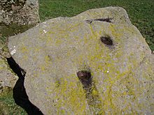 Image © 12pointer


