Although Tombo has posted part of this quote from Hutchinson I think it is worth posting the whole quote as it also mentions a second monument.
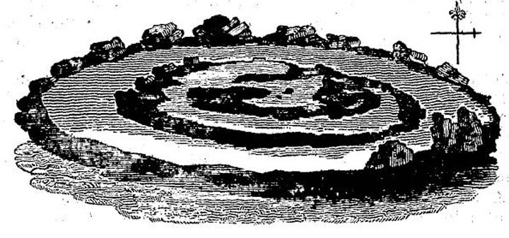
"A mile to the north of the village of Eggleston, above a little brook, stands an ancient monument, called Standing Stones, represented in the cut. It has consisted of an uniform circle of rough stones, with an inward trench, and in the centre a cairn;much of the materials have been taken away to repair the roads. At a small distance, and close by the brook, is a large tumulus, crossed from the east to the west by a row of stones. The adjacent ground, forming an inclining plain, was probably the field of battle, and the monuments mark the place of interment of some distinguished chieftains. There is no circumstance in history, which we can, with any certainty, fix here. The monuments are of distant antiquity."
The History & Antiquities of the County Palantine of Durham
Volume 3
Hutchinson
1785
This monument, a stone circle and enclosing ditch with a cairn standing inside it, was used as road building material in the nineteenth century and is now completely destroyed. Its memory lives on, however, in the name of nearby Standing Stones Farm. The County Durham Sites & Monuments Register describes it thus:
"Now lost, this stone circle may have been the most significant in south-west Durham located on a probable routeway between Weardale and Teesdale. Writing in 1794 Hutchinson described the site as follows 'A mile to the north of the village of Eggleston, above a little brook, stands an ancient monument, called Standing Stones. It has consisted of a uniform circle of rough stones, with an inward trench, and in the centre is a cairn. Much of the material has been taken away to repair the roads' (Hutchinson, W., A History of Durham, 1794, Volume 3, p. 227). By the late 19th century little was left of the monument 'Owing to so many of the stones having been removed for building purposes, no feature of any interest is left. About five rough stones lie on the grass, a plot of which bears a different colour and character to that of the rest of the field' ('FML', Visitor's Guide to Raby Castle, 1857, p. 57). Today nothing is visible above ground to indicate the position of the site. The OS correspondent writing in 1957 noted that 'No trace is now visible' (NY92NE4, Ordnance Survey Record Card, 1957). Field work as part of the English Heritage Monuments Protection Programme in March 2000 noted that at the position assumed to be the site of the stone circle there was still discernable a slight circular banked earthwork. The field was under pasture at the time and the feature located at NGR NY9829 2522."
The SMR also gives details of a more recent survey of the site:
"Geophysical and topographic survey carried out by Archaeological Services University of Durham on behalf of County Archaeology Section during October 2001. Survey designed to examine the site of a possible former stone circle, provisionally identified during MPP work in March 2000. Geophysical survey identified anomalies, provisionally interpreted as being a circular ditch and a circular arrangement of pits that could once have held upright stones. A depression was recorded that could have been caused by removal of one of these stones. All these features were located on a slightly raised, flatter area, identified through topographic survey." (sourced from "ASUD, Standing Stones Farm, geophysical and topographical surveys, 2001)

 Posted by fitzcoraldo
 Posted by TomBo