|
|

|
|
Idlebush BarrowBarrow / Cairn Cemetery
|
||||||||||||||||||||||||
|
|
|
Images (click to view fullsize) |
|

|
Fieldnotes |
|
|
This morning I set off bright and early to meet up with a small group of Ramblers - I haven't been out with them for a while but today's walk was up around Uffington White Horse (one of my very favourite places). The whole hill was covered in frost as we up walked towards it from the car park, everything shimmered in the winter sunlight. We crossed the Ridgeway heading apparently for the Lambourne Gallops. Mist covered downland lay to our right and although I had my camera with me I made no attempt to use it. A curlew called and then skylarks ... there was nowhere I would rather have been. Then came the surprise - as we came up towards the Gallops our walk leader mentioned Idlebush Barrow - I saw two barrows, the first being what looked like the remains of a long barrow. Then a well preserved disc/saucer barrow came into view. Again I made no attempt to photograph it as these sort of barrows only seem to show up well in aerial shots. I recommend seeing this barrow because of its proximity to Uffington and the brilliant views of the downs on the walk over to it. |
 Posted by tjj
14th January 2012ce |
|
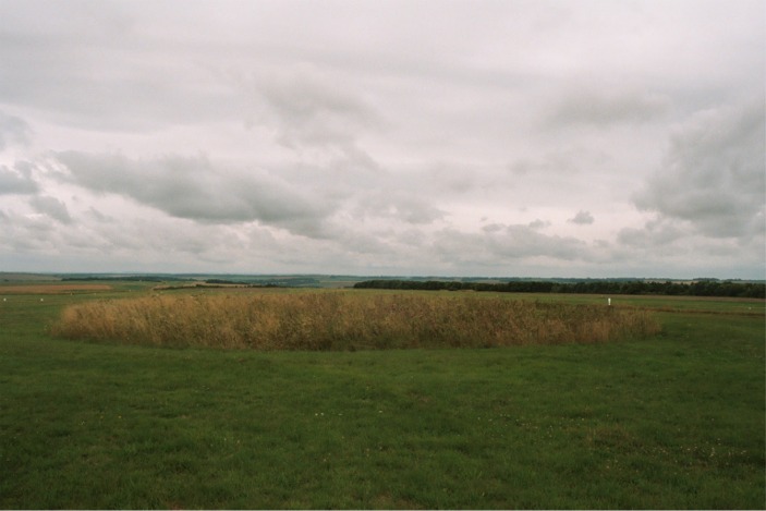
26 July 2003 Up the hill, passing the magnificent Uffington Castle enclosure or fort on my right, I reached the Ridgeway and followed it west for a short distance until a bridlepath appeared on the left. Orientating myself with the wooded land marked on the map and what I could see on the land, I followed the slightly overgrown path for about half an hour at a pretty brisk pace. This brought me to the twisting ribbon of woodland right beside the barrow cemetery. A short distance across the down I could see what looked like the top of a barrow largely hidden by a dip perhaps. Ah. No dip. Not the TOP of the barrow then? The whole thing? Uh-huh. Making a shape a bit like a little flying saucer sitting on the grassy plain, Idlebush Barrow itself looks to me to have been fairly denuded at some stage. Its outer edge is a very low embankment, with the small mound (less than 20 feet across, at a guess) rising only about 5 feet up from it. (Sorry if these guesstimates are way out, but what I'm trying to say is it's pretty small!!) A little further on across the down is another barrow, this time almost completely ploughed out, but enhanced (or at least made more noticeable by the long reedy grass it is covered by. It is just about possible to make out a slight embankment surrounding it. I've posted some photos of both. Retracing my steps and bearing west toward the strip of trees, I went back past both barrows looking for a 'tumulus' (another barrow really) marked on the map that I had missed. Well, if it's there, I missed it on the way back too, and it must be virtually invisible. I suspect that to most non-experts like myself, it is effectively ploughed out. A word of warning. Although they still look far from impressive, somehow my photos actually manage to make the barrows look more appealing than they seemed at the time…. Don't get your hopes up! This post appears as part of the weblog entry Glos 'n' Oxon, Picnic People & Stomping in the Sun – Part 2
|
1st August 2003ce Edited 1st August 2003ce |
Folklore |
|
|
A traveller was once lost on the Downs and was worried he wouldn't get safely to a village or town before it got dark. He met some shepherds sitting on the mound and asked them the way to Lambourn. The first man said nothing but just nodded his head in a particular direction. The second went to the trouble of raising one finger (not like that - politely) and pointing in the same direction. The third shepherd stirred himself enough to vaguely wave a toe. And lo, the place was consequently named Idle Tump. Despite being a pretty ridiculous story it does include your classic 'three times' motif. And it could indeed have been a place where shepherds would have a bit of a kip. This story is mentioned by Alfred Williams in his 'Villages of the White Horse' (1913). Another tale claims the bushes and trees on the barrow are too lazy to grow properly. "About 1800 some trees were planted on it which would not grow on account of the bleak situation," claimed Grinsell's mysterious source in 'Ancient Burial Mounds of England' (1936). This seems a very dull explanation to me. You'll have to go and look yourself to judge the truth of this one. David Nash Ford has suggested here http://www.berkshirehistory.com/legends/smithy02.html that the 'idle' actually derives from the meaning 'empty', implying that the barrow was unsuccessfully dug into for treasure in the dim and distant past. Also, as mentioned by wysefool below, the mound was known in Saxon times as Hawk's Low, but also apparently as Wade's Barrow ('Weardaes Beorh'): Wade being Wayland's father. So it seems that the mythic landscape that included Wayland's Smithy spread further out, and perhaps there were other local places that were part of the stories too. Those wishing to squeeze some fairies into the equation (that'll be me) will be able to get some mileage from this: As many as a dozen or moor horses run, and they started from Idle's Bush, which wur a vine owld tharnin'-tree in thay days - a very nice bush.Because fairies do like a good thorn tree. From The Scouring of the White Horse, by Thomas Hughes (1859). |
 Posted by Rhiannon
25th August 2004ce Edited 21st May 2013ce |
Miscellaneous |
|
|
There is a reference to this barrow and the adjacent one in the Anglo-Saxon charters. In 'Berkshire Barrows' by 'L.V. Grinsell' (Berkshire Archaeological Journal vol 42 part 2 - 1938) it is listed as: Hafoces Hlaew and Hundes Hlaew Mr O G S Crawford (note on OS map at Southampton) thinks these may be Idlebush barrow and the disc barrow to South, on 19 N.W. Hafoc is A-S for 'Hawk' and Hundes is probably A-S for 'Dog or Hound'. Many bronze age barrows in the area are named by Anglo-Saxons after animals or people from their own mythology (i.e. Waylands Smithy). |
4th November 2003ce |