The Modern Antiquarian
Log in
|
Register
Home
Latest Posts
Forums
Maps
Help
Browse Sites
News
Blog
Contributors
The Books
Select
-
Belgium
Denmark
Eire
France
Germany
Greece
Italy
The Netherlands
Norway
Portugal
Republic of Malta
Spain
Sweden
Switzerland
United Kingdom
County Cork
Glenleigh
Stone Circle
Glenleigh (Stone Circle) on The Modern Antiquarian, the UK & Ireland's most popular megalithic community website. 2 images, 1 fieldnote, plus information on many more ancient sites nearby and across the UK & Ireland.
Image © Bawn79 © 2011
Nearest Town:
Boherboy (12km NW)
OS Ref (IE):
W318904 /
Sheet: 79
Latitude:
52° 3' 41.45" N
Longitude:
8° 59' 40.24" W
Added by
FourWinds
Images (2)
Fieldnotes (1)
0 discussions
Start a topic
Show |
Hide
Web searches for Glenleigh
Flickr
Google
Google Images
The Megalithic Portal
Bing
Stone Pages
Wikipedia
Show map
(inline Google Map)
- Sites within 20 km -
-
Cloghboola Beg (5.35km S) (12 posts)
Cloghboola More (5.45km SW) (0 posts)
Cloghboola Beg (5.45km SW) (0 posts)
Knocknagappul (5.5km SSE) (2 posts)
Knocknakilla (6.44km SSW) (24 posts)
Glantane East (6.97km SSW) (7 posts)
Glantane East N (7.28km SSW) (14 posts)
Glantane East N (7.28km SSW) (5 posts)
Kilmeedy E (7.76km WSW) (0 posts)
Claragh E (7.76km WSW) (2 posts)
Stone Row, partially ruined (7.77km SE) (5 posts)
Shanralagh (7.8km WNW) (3 posts)
Knocknagappul (7.86km SE) (5 posts)
Glantane East S (7.9km SSW) (16 posts)
Carriganimmy (8.08km SSW) (15 posts)
Knockagappul 2 (8.24km SE) (6 posts)
Kilmeedy W (8.27km WSW) (0 posts)
Glantane South (8.4km SSW) (8 posts)
Carrigagulla NE (8.51km ESE) (17 posts)
Carrigagulla (8.7km ESE) (20 posts)
Claragh W (8.72km WSW) (2 posts)
Carrigagulla NE (9.16km ESE) (10 posts)
Carrigagulla (9.22km ESE) (7 posts)
Knockagappul 1 (9.57km SE) (5 posts)
Knocknagappul (9.71km SE) (3 posts)
Knocknakilla (10.05km S) (0 posts)
Knockraheen (10.3km S) (19 posts)
Carrigonirtane (10.32km SSW) (6 posts)
Knocknagappul (10.36km SE) (3 posts)
Oughtihery W (11.03km ESE) (9 posts)
Maulmore (11.08km ESE) (8 posts)
Lackaduv (11.22km S) (5 posts)
Cabragh N (11.31km SSW) (6 posts)
Cabragh (11.31km SSW) (4 posts)
Scrahanard (11.49km S) (15 posts)
Carrigonirtane (11.51km SSW) (4 posts)
Cabragh (11.75km SSW) (4 posts)
Knocknashannagh (11.97km W) (1 post)
Clashmaguire (12.47km SSW) (2 posts)
Caherbaroul (12.89km SE) (7 posts)
Clashmaguire (13.37km SSW) (1 post)
Kilberrihert large wedge tomb damaged (13.45km SE) (2 posts)
Gortnalicky (13.8km S) (1 post)
Oughtihery E (14.04km ESE) (9 posts)
Kilboultragh (14.68km SSE) (1 post)
Rylane (15.02km ESE) (5 posts)
Rylane (15.2km ESE) (3 posts)
Laharankeal (15.25km SE) (1 post)
Gneeves (15.35km ENE) (3 posts)
Kilmartin Lower (15.44km E) (1 post)
Deelish (15.72km SE) (4 posts)
Laharankeal (15.81km SE) (4 posts)
Lissacresig (15.85km SSW) (3 posts)
Lissacresig 1 (15.91km S) (4 posts)
Lissacresig 3 (15.94km SSW) (4 posts)
Lissacresig 2 (15.94km SSW) (5 posts)
Garrane (16.05km ENE) (7 posts)
Glandine (Monkey's Bridge) (16.32km E) (15 posts)
Farrankeal (16.5km W) (2 posts)
Farrankeal (16.5km W) (1 post)
An Seisear (16.92km E) (14 posts)
Bealick (17.03km SE) (0 posts)
Carrigaphooca (17.05km S) (7 posts)
Gowlane North (17.2km E) (8 posts)
Inchinlinane (17.34km S) (5 posts)
Ballymakeery (17.46km SW) (5 posts)
Shanacloon (17.83km SW) (5 posts)
St Abban's Grave (17.83km SW) (4 posts)
St Abban's Grave (17.83km SW) (1 post)
Bealick (17.86km SSE) (3 posts)
City of Shrone (18.05km WSW) (15 posts)
City of Shrone (18.05km WSW) (2 posts)
Glenreagh (18.34km WNW) (1 post)
Gortyleahy (18.48km SSE) (4 posts)
Cools (18.67km SSW) (3 posts)
Eastern Pap (18.95km WSW) (6 posts)
Bweeng (19.08km E) (6 posts)
Gortnatubbrid (19.1km SW) (4 posts)
Gortnatubbrid (19.1km SW) (13 posts)
Kylefinchin 2 (19.21km S) (5 posts)
Kylefinchin (19.23km S) (1 post)
Ballyvoge 1 (19.26km SSW) (6 posts)
The Paps of Anu (19.55km WSW) (7 posts)
Gortanimill (19.62km SW) (16 posts)
- Add -
-
Add news
Add an image
Add fieldnotes
Add folklore
Add miscellaneous
Add a link
-
Add a site
Add a nearby facility
Add an alternative name/spelling
Images
(click to view fullsize)
Add an image
Fieldnotes
Add fieldnotes
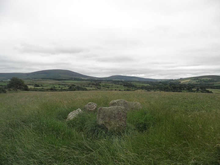
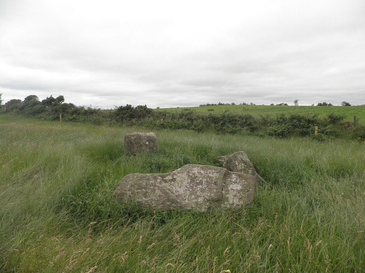
This stone circle is easy to access being only two fields from the road. It is a small 5 stone circle which Jack Roberts states has a possible winter solstice alignment.
Comments (0)
|
Add a comment
|
Permalink
Posted by
bawn79
20th October 2011ce