|
|

|
|
The Devil's Ring and FingerStanding Stones
|
|
|
|
Images (click to view fullsize) |
|


|
Fieldnotes |
|
|
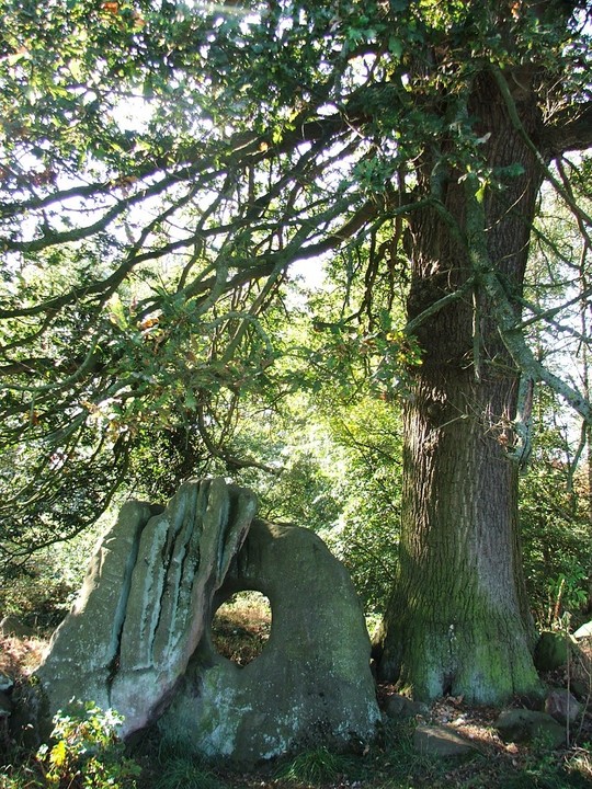
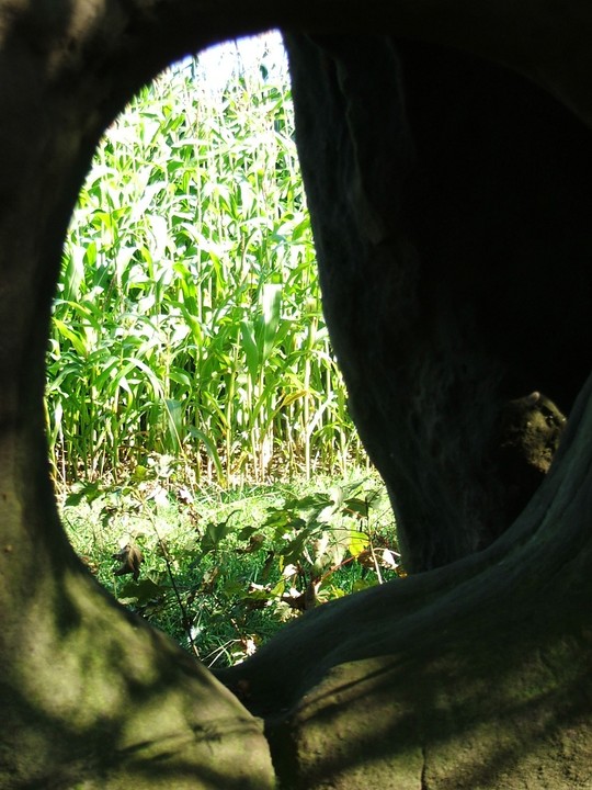
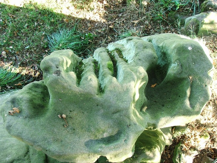
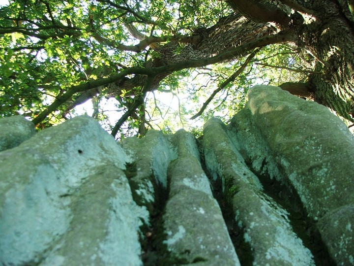
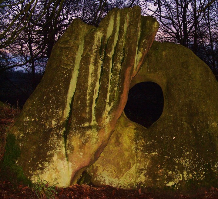
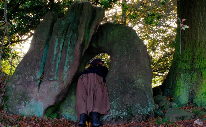
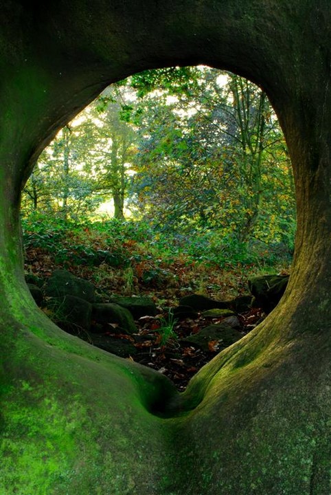
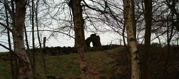
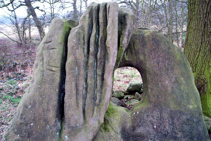
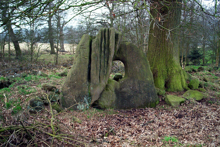
The devils ring and finger are less than a 30 minute drive from my house, but to my shame ive only been here once, and that was so long ago i didnt have a digital camera, it was winter i think. But this is this years indian summer and after a Shropshire hillfort I felt a quick reintroduction could be easily accomplished. With no OS map I was forced to check out google earth and street map the day before and then trust to the road map and memory. Both worked a treat, no problem at all. After only a ten minute walk from the car I find myself at the stones, bigger than I remember, and now totally hidden from prying eyes by this years crops, corn. They are very perplexing are they not, this dynamic duo, where did they come from ?, what were they part of ? part of a stone circle ? like at Men an tol, I dont buy that. Or part of a burial chamber, with a portholed entrance, might we think of the Bridestones near Congleton, but that chamber has a broken portholed entance, difficult to tell. But thats what I prefer, an exact duplicate to the Bridestones. Its a secluded spot, corn on one side and the copse on the other, just the stones, me and a big tree, judging from the old picture supplied by Rhiannon, the tree was big a hundred years ago. Both stones are deeply weathered, long deep runnels striate the standing stone, but the holed stone is less weathered, because it spent so long hidden from the elements under a capstone presumably. I will endeaver to get more familiar with the immediate surroundings,perhaps a wintry visit with no crops would suit me sir. |
 Posted by postman
28th September 2011ce |
|
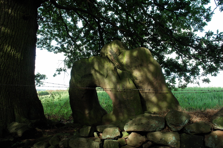
As there isn't much around here to see (ah, the midlands) I was pleased to find this site in daytrip-distance and set off with plenty of daylight hours remaining only to get stuck on the M6. Fabulous. Got to Mucklestone near Market Drayton at about 3pm, well in time to see what we wanted to see before it got dark, only to discover that there isn't a thing in Mucklestone! Lots of driving around country lanes bought me to the next town over, Norton in Hales, where I gave up trying to find it myself and asked a local if he knew (by any chance!) where the Devils RIng and Finger was... HE DID!! So, from St Chads church in Norton in Hales, you take a left and follow the road until it turns to the right, dont turn, stay on the road (Forge Lane/Road) and stay on this road as it turns into a track, and then a mostly mud and grass walkway until you arrive at a farm. At this point (as we still cant see anything) we assume we are in the wrong place and ask at the farm. The very nice lady directs us across the track, past the horse and over a gate into a field on the otherside of the stream. From there we follow the drystone wall up to a little copse and the monument is hiding at the back against a barbedwire fence. Its a shame for it really as its been moved at some point over the last 300years and it just "dumped" out of the way. But its considerably bigger than Men-an-Tol and worth a clamber through and a quick circumambulation. We were there for sunset, which came fast, and we had to leave quickly to avoid getting stranded in the boggy field below. Well worth the trip if you're in the area. |
 Posted by faerygirl
16th January 2010ce |
|
Always nice to see a rock with hole in it, makes a break from the norm..... walking in a south westerly direction away from the site the land sweeps gently down to lake and river with a small number of copse woods islands surrounded by heavily ploughed farmland. after closer inspection the copse cointained a fair amount of good sized stones, some it seems could have been placed here and are possibly in there original position while the majority prosumably dragged into the edge of the field (if indeed that was the case). The nearest copse to the Ring and Finger had the greatest density of what appeared to be standing stones within it and a possible small circle with evidence of more stones running off south south westerly(ish) visible now only in the isolated (fenced off) patches of scrub and copse. A couple of hundered yards away down towards the lake, almost underneath the main house there is a huge mound just away from the shoreline, on the top is a worked stone of a different composite lying on its side. I must also include here 1 (or2) stone(s) lying midway between the mound and the ring and finger (which I have posted in the image section) . There are also a few humps and tumps about on both sides of the river. Getting here can be tricky without an O.S. map. There are no signs posts. When you arrive into Norton in Hale from mucklestone drive past the pub and as the road bends right turn left into Forge lane/St/road , find somewhere to park and get onto the footpath (on the left where the houses finish) which eventually leads upto the site (about 5/10 mins walk). All we had was a road atlas which got us within locality of the nearest pub - Once inside asking for Local Knowledge, (where I resisted the question "does norton inhale?") the guy behind the bar repeatedly told us, "In all my 27 years I have never found the need to go up there myself" - "Its just a rock in a field" (which answered my question - obviously he didn't). But don't be put off by my tale of Norman the barman - in - the only pub - of the prettiest - best looked after - village in Shropshire.. NB* The farmer told us of a Roman road which ran near by and of the stately homes 18th century owners/ground keepers fondness of landscape gardening. That coupled with the many years of heavy farming (in my opinion) its little wonder that what is left here is probably a very tiny fragment of its former self. |
 Posted by broen
17th February 2003ce Edited 17th May 2003ce |
|
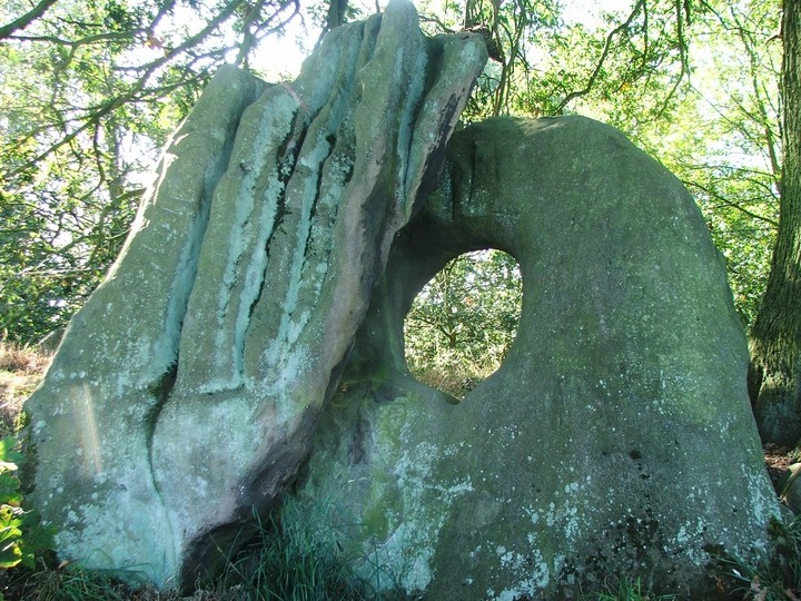
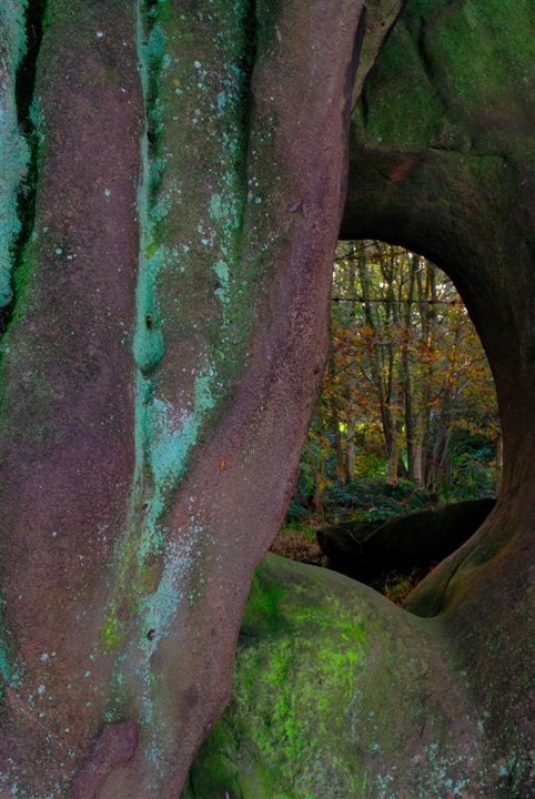
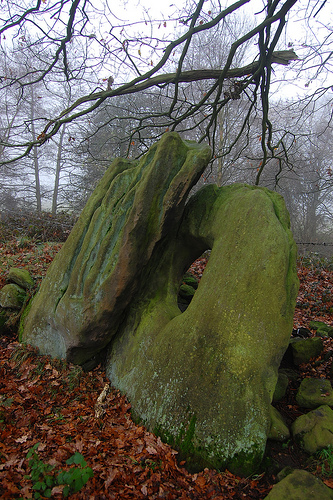
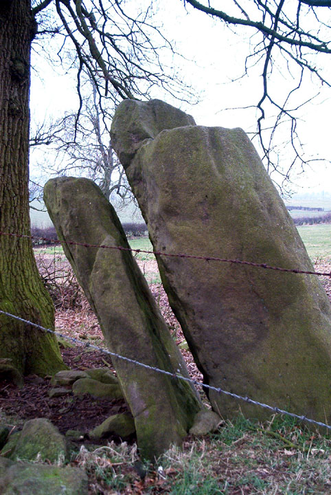
127 707379 Best approach is from the Mucklestone side off of the B5415. The other approach South of Norton in Hales ends with the footpath/track ending at a farm with two shut gates and a STOP sign beyond because it is a rare breeds minimum disease area. B5415, heading south, just beyond Napley is a red telephone box set back from the road, opposite is a junction. Turn right into it, about 20 metres ahead on your right is ample parking (the owner of the large house opposite told us we could park there). Walk along the single lane tarmaced road (lined with young oak), follow this road around a left bend until you see two keeper's cottages either side of the road. Just beyond the cottages there is a clearly marked bridleway stile and gate on the right. Cross into the field. Keep to the hedge until you approach a coppice, which is unfortunately fenced off with new barbed wire. On the other side of the fence are fir tree saplings, some dead, with more mature trees behind them. If you have decided to trepass, walk through the copice, within moments you should reach another barbed wire fence. Walk along the fence and you will reach the stones, again within moments. The stones lean, the one without the porthole slightly infront of the other. It is worn with deep vertical grooves from weathering and stands to a height of approx 6ft. The porthole stone is more squat, roughly a little more than half the height of the other. The hole appears intentional, rather than weather worn, and is big enough for me to climb through (I'm 6'5"). A word of warning if you do climb through, remember there is a rusted barbed wire fence behind it. I found it difficult to imagine the pair of stones in their present position as part of a chamber. The way one stone stands slightly infront of the other gives an impression that they have been moved. In addition: Norton in Hales church stands in a circular churchyard. |
Posted by elderford 28th September 2002ce |
| This little monument is often overlooked but is one of the very few Midland Megaliths. Near the village of Mucklestone, two stones lie in a hedge: an upright about 2m high next to a holed stone about 2m across with a hole c.50cm in diameter cut into it. The stones appear to have been moved to the hedge from the nearby field and may have formed a stone setting similar to that at Men an Tol in Cornwall. |
Posted by Dave M 25th June 2000ce |
Folklore |
|
... Arbour Farm was next reached, and here, by the kind permission of Mr Meadows and Mr Bourne, the club visited the ancient Celtic stones known as the "Devil's Ring and Finger." There are two very large stones, one, an upright stone, grooved longitudinally, and with lateral grooves, where, possibly, arrow heads and pike heads may at some time have been sharpened, and shaped like a huge finger, represents the finger of his Satanic Majesty; and a broad flat stone, with a hole almost circular in the middle, is the ring. The stones belong probably to prehistoric times.From a report of the N.S. Field Club, in the Newcastle Guardian, 22nd August 1908. |
 Posted by Rhiannon
30th May 2023ce Edited 30th June 2023ce |
Links |
|
Staffordshire Past TrackSome archive photos of the stones, including keen visitors. |
Posted by Rhiannon 21st November 2009ce Edited 30th May 2023ce |