The Modern Antiquarian
Log in
|
Register
Home
Latest Posts
Forums
Maps
Help
Browse Sites
News
Blog
Contributors
The Books
Select
-
Belgium
Denmark
Eire
France
Germany
Greece
Italy
The Netherlands
Norway
Portugal
Republic of Malta
Spain
Sweden
Switzerland
United Kingdom
Northern Germany
Lower Saxony
Löningen 3
Passage Grave
Löningen 3 (Evenkamp/Ganggrab auf dem Ladenesch/Sprockhoff Nr. 973) (Passage Grave) on The Modern Antiquarian, the UK & Ireland's most popular megalithic community website. 3 images, plus information on many more ancient sites nearby and across the UK & Ireland.
Image © Uwe Häberle 08/2014
Also known as:
Evenkamp
Ganggrab auf dem Ladenesch
Sprockhoff Nr. 973
Latitude:
52° 43' 2.39" N
Longitude:
7° 41' 51" E
Added by
Nucleus
Images (3)
0 discussions
Start a topic
Show |
Hide
Web searches for Löningen 3
Flickr
Google
Google Images
Bing
Stone Pages
Wikipedia
Show map
(inline Google Map)
- Sites within 20 km -
-
Löningen 2 (0.61km NE) (1 post)
Löningen 1 (4.61km ENE) (3 posts)
Herßum (6.33km WNW) (11 posts)
Holte-Lastrup 1 (7.21km W) (4 posts)
Holte-Lastrup (7.23km W) (1 post)
Holte-Lastrup 2 (7.25km W) (3 posts)
Berge (8.64km S) (0 posts)
Lähden 1 (10.03km W) (6 posts)
Garener Steine (10.64km NNE) (3 posts)
Garener Steine 2 (10.66km NNE) (3 posts)
Garener Steine 1 (10.66km NNE) (5 posts)
Fuhrenkamp 1 (10.83km NE) (5 posts)
Fuhrenkamp (10.85km NE) (1 post)
Fuhrenkamp 2 (10.88km NE) (3 posts)
Fuhrenkamp 3 (10.88km NE) (4 posts)
Hüven-Süd (11.52km WNW) (5 posts)
Oldendorfer Hünensteine (11.63km NE) (8 posts)
Lahn 5 (11.94km WNW) (3 posts)
Lahn 4 (12.25km WNW) (2 posts)
Hüven-Nord (12.49km WNW) (16 posts)
Westerloh 1 (12.58km W) (3 posts)
Lahn 1 (12.61km NW) (0 posts)
Lahn 2 (12.68km NW) (4 posts)
Lahn 3 (12.77km NW) (9 posts)
Lähden 2 (13.23km W) (4 posts)
Westerloh 2 (13.25km W) (5 posts)
Groß Berßen 10 (13.68km W) (6 posts)
Groß Berßen 7 (14.07km W) (8 posts)
Groß Berßen 6 (14.12km W) (4 posts)
Groß Berßen 5 (14.15km W) (3 posts)
Groß Berßen 8 (14.16km W) (10 posts)
Groß Berßen 4 (14.17km W) (2 posts)
Hünensteine - Lindern (14.18km NNE) (5 posts)
Groß Berßen 3 (14.2km W) (1 post)
Hünengräberstraße des Hümmling (14.23km W) (1 post)
Groß Berßen 2 (14.64km W) (6 posts)
Groß Berßen 1 (14.87km W) (8 posts)
Lastrup 1 (15.07km NE) (5 posts)
Lastrup 2 (15.09km NE) (4 posts)
Ostenwalde 1 (15.15km NW) (6 posts)
Hekese B (15.15km SE) (5 posts)
Hekeser Steine (15.19km SE) (1 post)
Hekese A (15.22km SE) (5 posts)
Ostenwalde 3 (15.25km NW) (0 posts)
Ostenwalde 2 (15.33km NW) (2 posts)
Groß Berßen 9 (15.66km W) (8 posts)
Lindern (15.76km NNE) (3 posts)
Bockraden (16.09km SE) (2 posts)
Schlingsteine (16.38km NNE) (6 posts)
Restruper Näpfchenstein (16.69km SE) (5 posts)
Restrup (16.7km SE) (5 posts)
Klein-Berßen 2 (16.92km W) (6 posts)
Sögel 1 (17.77km WNW) (2 posts)
Sögel 3 (17.94km WNW) (7 posts)
Sögel 2 (17.96km WNW) (6 posts)
Werlte (18.1km NNW) (13 posts)
Klein-Berßen 1 (18.32km W) (5 posts)
Harrenstätte 1 (18.44km NNW) (7 posts)
Dalum (18.86km SSE) (6 posts)
Spahn 1 (18.86km NW) (3 posts)
Groß-Stavern 2 (18.91km W) (2 posts)
Klein-Stavern 5 (18.98km W) (4 posts)
Klein-Stavern 4 (19km W) (3 posts)
Klein-Stavern 3 (19.01km W) (3 posts)
Groß-Stavern 1 (19.01km W) (8 posts)
Klein-Stavern 2 (19.04km W) (3 posts)
Deymanns Mühle (19.04km W) (2 posts)
Spahn 2 (19.25km NW) (0 posts)
- Add -
-
Add news
Add an image
Add fieldnotes
Add folklore
Add miscellaneous
Add a link
-
Add a site
Add an alternative name/spelling
Images
(click to view fullsize)
Add an image
Photographs:
Maps / Plans / Diagrams:
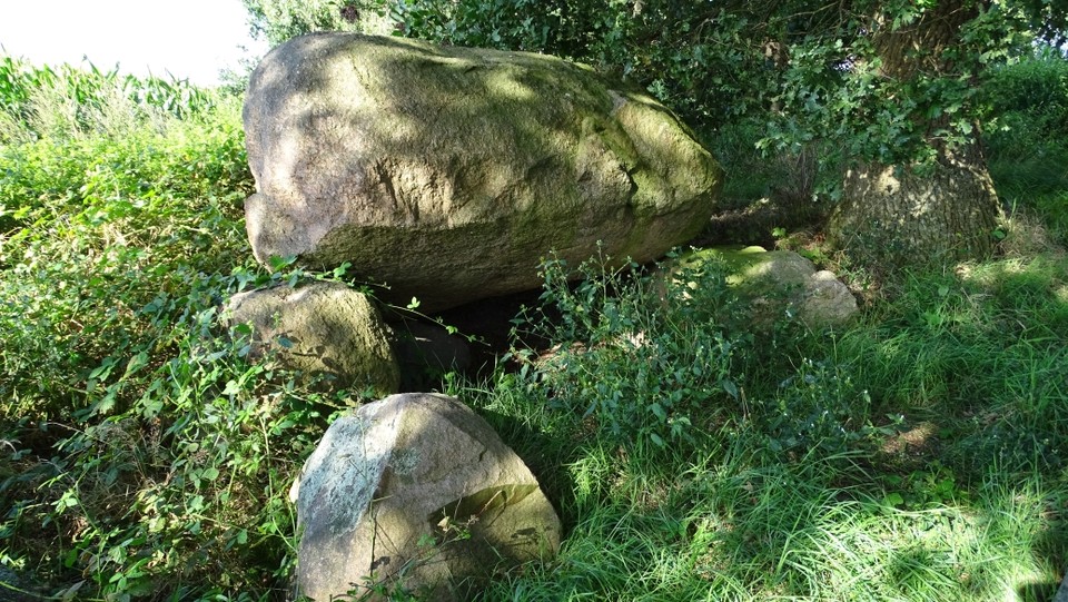
 Image © Uwe Häberle 08/2014
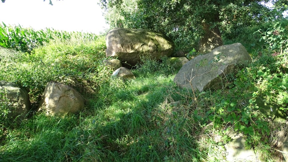

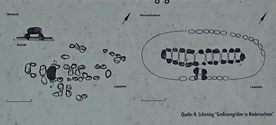
 Maps / Plans / Diagrams: