The Modern Antiquarian
Log in
|
Register
Home
Latest Posts
Forums
Maps
Help
Browse Sites
News
Blog
Contributors
The Books
Select
-
Belgium
Denmark
Eire
France
Germany
Greece
Italy
The Netherlands
Norway
Portugal
Republic of Malta
Spain
Sweden
Switzerland
United Kingdom
County Cork
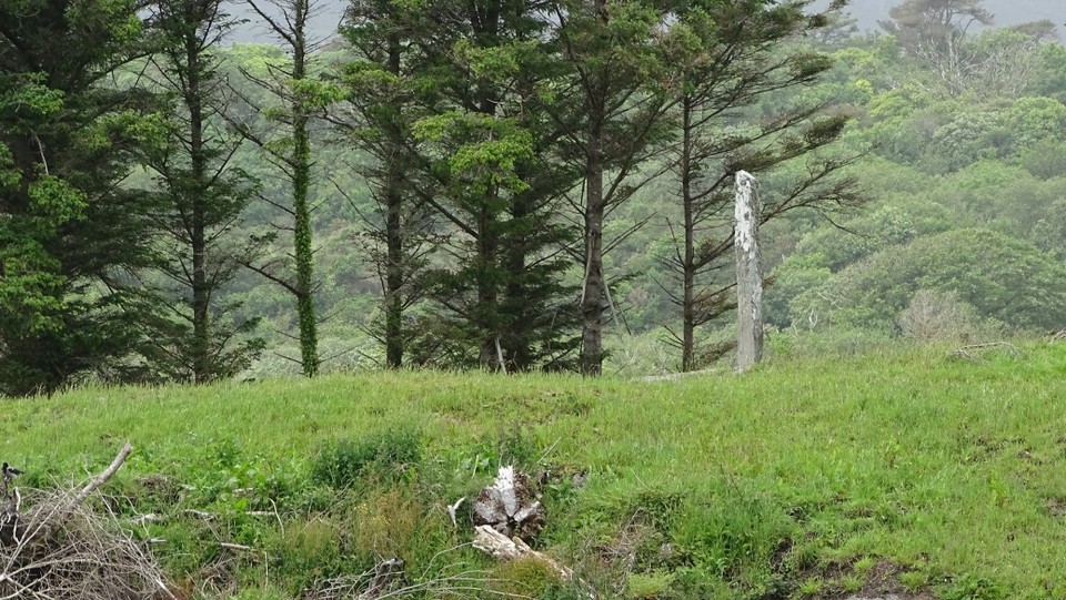
Derreenataggart Middle
Standing Stone / Menhir
Derreenataggart Middle (Standing Stone / Menhir) on The Modern Antiquarian, the UK & Ireland's most popular megalithic community website. 2 images, plus information on many more ancient sites nearby and across the UK & Ireland.
Image © Uwe Häberle 06/2014
Nearest Town:
Sneem (21km N)
OS Ref (IE):
V6717545748 /
Sheet: 84
Latitude:
51° 38' 55.25" N
Longitude:
9° 55' 9.52" W
Added by
Nucleus
Images (2)
0 discussions
Start a topic
Show |
Hide
Web searches for Derreenataggart Middle
Flickr
Google
Google Images
The Megalithic Portal
Bing
Stone Pages
Wikipedia
Show map
(inline Google Map)
- Sites within 20 km -
-
Derreenataggart West (1.01km WNW) (31 posts)
Derrymihin West (2.1km ENE) (3 posts)
Fanahy (2.24km WSW) (4 posts)
Teernahillane (3.16km WSW) (3 posts)
Teernahillane (3.16km WSW) (1 post)
Teernahillane (3.44km W) (4 posts)
Rodeen 3 (3.45km NE) (4 posts)
Teernahillane (3.46km W) (9 posts)
Rodeen 2 (3.51km NE) (5 posts)
Kilmackowen (3.76km N) (17 posts)
Rodeen 1 (3.83km NE) (3 posts)
Kilmackowen (3.84km N) (9 posts)
Cloontreem (3.85km NE) (15 posts)
Knockoura (4.19km WSW) (2 posts)
Gour (4.39km WSW) (10 posts)
Coulagh (5.17km WNW) (1 post)
Coulagh (5.32km WNW) (5 posts)
Ardacluggin (5.84km W) (1 post)
Ardacluggin (6.28km W) (4 posts)
Kealoge (6.71km WSW) (3 posts)
Urhin (7.01km W) (5 posts)
Ballycrovane (7.29km NNW) (18 posts)
Kealoge (8.01km W) (6 posts)
Hag of Beara (8.21km NW) (9 posts)
Cahermore (8.45km WSW) (5 posts)
Ardgroom Outward (10.16km NNE) (34 posts)
Killough West (10.9km WSW) (9 posts)
Coomgira (11.54km ENE) (6 posts)
Glashananinnaun (11.72km NNE) (5 posts)
Shronebirrane (12.65km NE) (22 posts)
Loughane More (13.54km WSW) (6 posts)
Cashelkeelty NW (14.01km NNE) (12 posts)
Cashelkeelty SE (14.15km NNE) (13 posts)
Caherurlagh (14.23km ESE) (6 posts)
Peakeen (14.89km E) (6 posts)
Clogherane (15.11km NE) (3 posts)
Clogherane (15.12km NE) (3 posts)
Reenkilla (15.31km NE) (5 posts)
Cappaleigh North (15.7km ENE) (4 posts)
Drumlave (15.74km ENE) (11 posts)
Kilcaskan (15.97km ENE) (5 posts)
Kildromalive (16.28km ENE) (5 posts)
Farranamanagh (16.94km E) (6 posts)
Kilcrohane (17.09km E) (9 posts)
Farranamanagh (17.21km E) (2 posts)
Staigue Bridge (17.43km NW) (13 posts)
Staigue (17.52km NW) (0 posts)
Ballynahowen (18.03km ENE) (15 posts)
Lehid (18.16km NE) (2 posts)
Gort na Gainimhe (18.21km WSW) (6 posts)
Leitrim Beg (18.41km ENE) (21 posts)
Caherdaniel (18.5km WNW) (4 posts)
Staigue Cashel (18.54km NW) (21 posts)
Lehid (18.71km NE) (3 posts)
Lehid (18.84km NE) (1 post)
Darrynane More (18.92km WNW) (8 posts)
Coomnahorna East (18.93km WNW) (0 posts)
Drombohilly Wedge Tomb (18.94km NE) (2 posts)
Killenough (19.08km ENE) (5 posts)
Drombohilly (19.1km NE) (32 posts)
Gorteanish (19.7km E) (14 posts)
The Waters (19.87km WSW) (3 posts)
- Add -
-
Add news
Add an image
Add fieldnotes
Add folklore
Add miscellaneous
Add a link
-
Add a site
Add a nearby facility
Add an alternative name/spelling
Images
(click to view fullsize)
Add an image
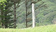 Image © Uwe Häberle 06/2014