The Modern Antiquarian
Log in
|
Register
Home
Latest Posts
Forums
Maps
Help
Browse Sites
News
Blog
Contributors
The Books
Select
-
Belgium
Denmark
Eire
France
Germany
Greece
Italy
The Netherlands
Norway
Portugal
Republic of Malta
Spain
Sweden
Switzerland
United Kingdom
Scotland
Angus
Turin Hill
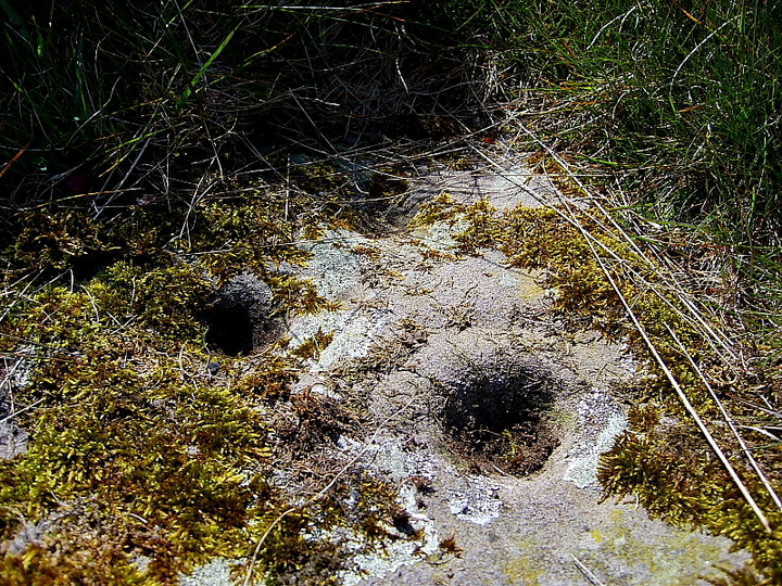
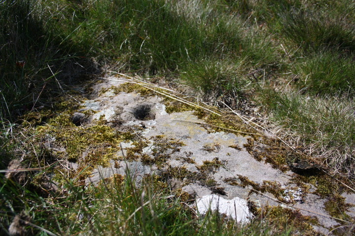
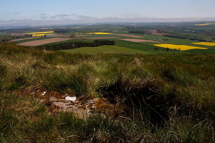
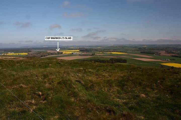
Turinhill Craigs
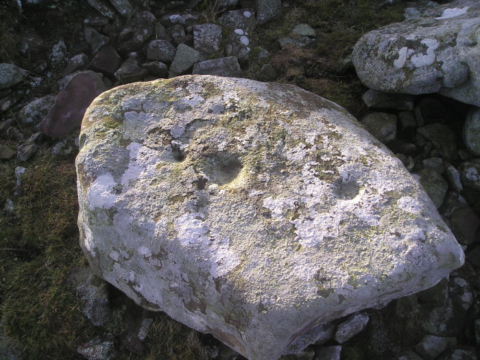
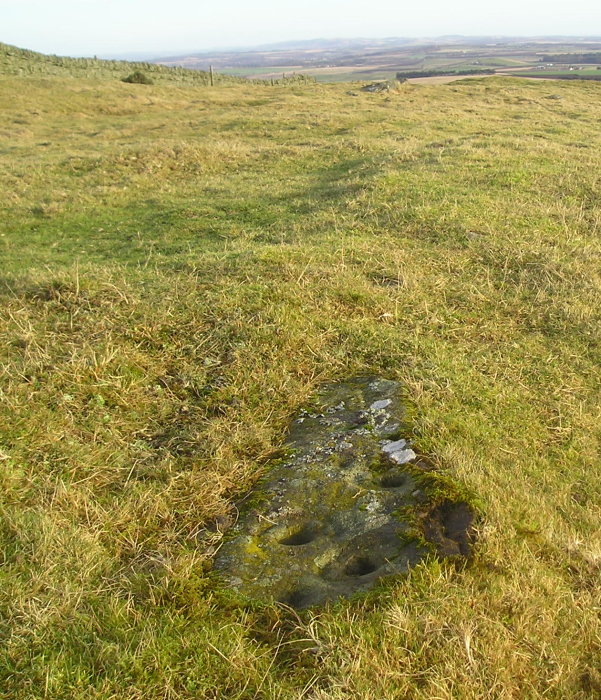
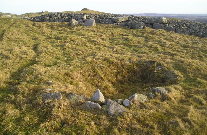
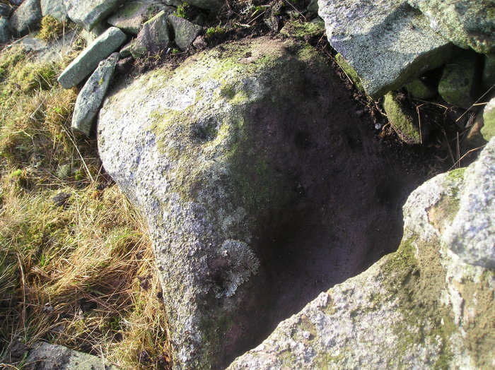
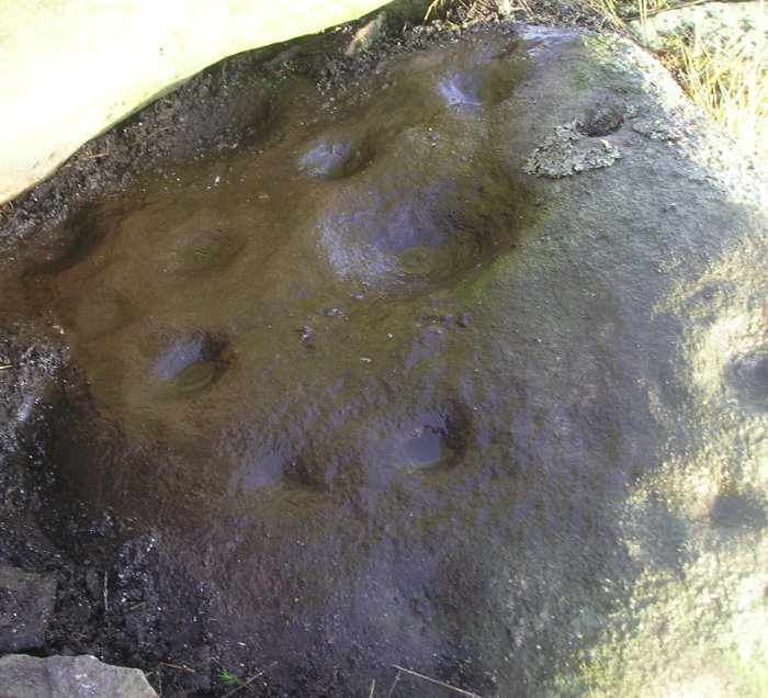
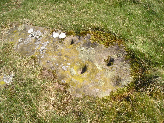
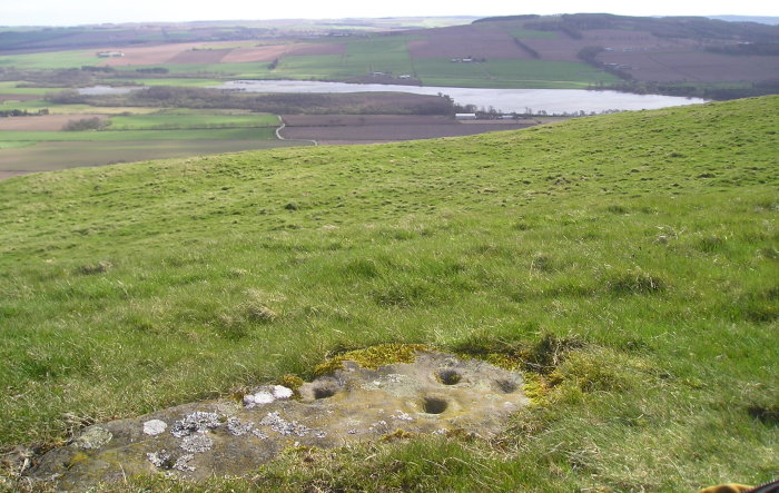
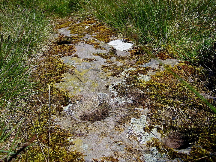
Cup and Ring Marks / Rock Art
Turinhill Craigs (Cup and Ring Marks / Rock Art) on The Modern Antiquarian, the UK & Ireland's most popular megalithic community website. 13 images, plus information on many more ancient sites nearby and across the UK & Ireland.
Image © tiompan
Nearest Town:
Forfar (7km WSW)
OS Ref (GB):
NO516534 /
Sheet: 54
Latitude:
56° 40' 11.43" N
Longitude:
2° 47' 23.43" W
Added by
GLADMAN
Images (13)
1 discussion topic
Start a topic
Show |
Hide
Web searches for Turinhill Craigs
Flickr
Google
Google Images
MAGIC
The Megalithic Portal
Bing
Stone Pages
Streetmap.co.uk
Wikipedia
Show map
(inline Google Map)
- Sites within 20 km -
-
Turin Hill (0.22km W) (18 posts)
Carsegownie (1.5km WNW) (18 posts)
Pitscandly (1.87km W) (3 posts)
Reswallie (2.19km SW) (1 post)
Finavon (2.42km NW) (2 posts)
Westerton (2.46km E) (18 posts)
Finavon Hillfort (2.47km NW) (15 posts)
Aberlemno 3 (2.59km NNE) (2 posts)
Aberlemno (2.59km NNE) (0 posts)
Aberlemno 2 (2.59km NNE) (5 posts)
Hill of Finavon (2.95km W) (1 post)
Pitscandlie (3.24km WSW) (15 posts)
Melgund Cottage (3.36km NNE) (9 posts)
Girdlestane (3.79km SE) (3 posts)
Guthrie Hill (4.54km E) (8 posts)
Haer Cairn (5.06km NNW) (5 posts)
Carse Grey (5.39km W) (10 posts)
Battledykes (5.81km W) (8 posts)
Dumbarrow Hill (6.52km ESE) (9 posts)
Vayne (6.86km NW) (6 posts)
Law Of Windsor (7.03km NNW) (11 posts)
St Ninian's Well (7.5km NW) (1 post)
Kintrockat (7.74km NE) (6 posts)
Killievair (8.78km NE) (3 posts)
Cairn Knap (8.84km E) (10 posts)
Noranside (9km WNW) (13 posts)
Law Of Coull (9.32km WNW) (4 posts)
Kirkbuddo Cairn (9.98km S) (10 posts)
Conon Souterrain (10.05km ESE) (6 posts)
Easter Memus (10.31km WNW) (12 posts)
Carmyllie Hill (10.39km SE) (2 posts)
Ogil (10.73km WNW) (8 posts)
Balhall (10.87km NNW) (3 posts)
Douglamuir (11.37km E) (2 posts)
Beattie's Cairn (11.52km NNW) (1 post)
Balmuckety (11.56km WSW) (7 posts)
Gallows Hillock (11.7km N) (6 posts)
Labothie Hill (12.09km SSW) (6 posts)
Balzeordie (12.14km NNE) (5 posts)
Hare Cairn (12.36km SSW) (6 posts)
Gallow Hill (Cortachy) 2 (12.37km W) (7 posts)
Gallow Hill (Cortachy) (12.47km W) (9 posts)
Kirriemuir Hill (12.51km W) (11 posts)
Hatton (Labothie Hill) (12.61km SSW) (4 posts)
Labothie Hill 2 (12.62km SSW) (4 posts)
White Caterthun (13.08km NNE) (21 posts)
Elliot Water (13.17km SE) (8 posts)
Caddam (13.37km W) (11 posts)
St Arnold's Seat (13.41km WNW) (5 posts)
Bell Hillock (13.59km W) (7 posts)
Arniefoul (13.73km SW) (7 posts)
Brown Caterthun (13.93km NNE) (6 posts)
Cortachy (13.96km W) (13 posts)
Templewood (14.04km NE) (5 posts)
Glamis (14.49km WSW) (5 posts)
Balnagarrow (14.51km W) (3 posts)
Huntlyhill (14.67km NE) (17 posts)
Carrot Hill (14.71km SSW) (2 posts)
Meams Farm (14.73km W) (6 posts)
Meams Hill (14.73km W) (8 posts)
Bridgend of Lethnot (14.91km N) (9 posts)
Old Montrose Cursus (14.91km ENE) (2 posts)
Ballownie (15.05km NE) (12 posts)
Castle Hill (15.63km W) (8 posts)
Castle Hill (Meams) (15.89km W) (12 posts)
Castle Hill Wood (15.96km W) (10 posts)
Reedie (16.11km WSW) (7 posts)
Balstard (16.43km W) (8 posts)
Gallows Knap (16.43km NE) (12 posts)
Reedie 2 (16.47km WSW) (4 posts)
Fordhouses (16.54km ENE) (5 posts)
Gallows Knowe (16.58km ENE) (8 posts)
Maryton (16.64km ENE) (9 posts)
Lendrick Lodge Stone (16.69km WSW) (15 posts)
Tealing Stones (16.92km SW) (16 posts)
Tealing Hill settlement (16.93km SW) (3 posts)
Dickmount Law (16.93km E) (7 posts)
Tealing Hill cist (16.97km SW) (3 posts)
Balloch (17.08km W) (6 posts)
Tealing Hill (17.1km SW) (3 posts)
Culhawk (17.18km W) (10 posts)
Mains Of Edzell (17.35km NNE) (1 post)
Huntingfaulds (17.38km SW) (5 posts)
Capo (17.45km NE) (14 posts)
Gallow Hill (17.5km SW) (10 posts)
Kirkton Hill (17.72km W) (8 posts)
Ascreavie Hill (17.9km W) (8 posts)
Corogle Burn (18.02km W) (14 posts)
Carlunie (18.07km WSW) (5 posts)
Gallow Hill 2 (18.07km SW) (4 posts)
Glen Wood (18.4km ENE) (8 posts)
Denoon Law (18.42km WSW) (15 posts)
Tealing (18.46km SW) (31 posts)
Carlungie (18.47km S) (25 posts)
St Bride's Ring (18.54km S) (1 post)
Airlie (18.59km WSW) (24 posts)
Prieston Hut Circles (18.62km SW) (3 posts)
Drumsturdy / Laws (18.62km S) (15 posts)
Hill of Prieston (18.64km SW) (16 posts)
Castle Rock (18.83km E) (4 posts)
Witch Hillock (18.85km NE) (15 posts)
Ardestie (18.91km S) (29 posts)
Maiden Castle (Arbroath) (18.94km E) (6 posts)
Gaylet Pot (18.95km E) (6 posts)
West Mains of Ethie (19.01km E) (5 posts)
Lud Castle (19.18km E) (5 posts)
Prail Castle (19.26km E) (11 posts)
Craig Hill (19.39km SSW) (12 posts)
Red Head (19.41km E) (5 posts)
Craigowl (19.47km SW) (6 posts)
Cantsmill (19.55km WSW) (7 posts)
Meikle Kenny Group C (19.74km W) (3 posts)
Meikle Kenny Standing Stone (19.74km W) (8 posts)
Meikle Kenny (19.74km W) (3 posts)
Meikle Kenny Recumbent? (19.74km W) (4 posts)
Meikle Kenny Group B (19.74km W) (5 posts)
Whitehillocks (19.81km WNW) (9 posts)
Elephant Rock (19.93km ENE) (4 posts)
- Facilities within 20 km -
-
Pictavia (Museum: 9.1 km NNE)
The Drovers Inn (Pub: 10.5 km WNW)
Glen Clova Hotel (Hotel: 13.4 km W)
Brandy Burn House (Bed & Breakfast: 13.4 km W)
- Add -
-
Add news
Add an image
Add fieldnotes
Add folklore
Add miscellaneous
Add a link
-
Add a site
Add a nearby facility
Add an alternative name/spelling
Images
(click to view fullsize)
Add an image
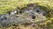 Image © tiompan