The Modern Antiquarian
Log in
|
Register
Home
Latest Posts
Forums
Maps
Help
Browse Sites
News
Blog
Contributors
The Books
Select
-
Belgium
Denmark
Eire
France
Germany
Greece
Italy
The Netherlands
Norway
Portugal
Republic of Malta
Spain
Sweden
Switzerland
United Kingdom
County Cork
Cappaleigh North
Standing Stone / Menhir
Cappaleigh North (Standing Stone / Menhir) on The Modern Antiquarian, the UK & Ireland's most popular megalithic community website. 3 images, 1 fieldnote, plus information on many more ancient sites nearby and across the UK & Ireland.
Image © Michael Mitchell
Nearest Town:
Durrus (15km ESE)
OS Ref (IE):
V822505 /
Sheet: 84
Latitude:
51° 41' 41.01" N
Longitude:
9° 42' 14.08" W
Added by
Meic
Images (3)
Fieldnotes (1)
0 discussions
Start a topic
Show |
Hide
Web searches for Cappaleigh North
Flickr
Google
Google Images
The Megalithic Portal
Bing
Stone Pages
Wikipedia
Show map
(inline Google Map)
- Sites within 20 km -
-
Drumlave (0.22km SE) (11 posts)
Kildromalive (0.95km NNE) (5 posts)
Kilcaskan (1.84km NNW) (5 posts)
Ballynahowen (2.36km ENE) (15 posts)
Leitrim Beg (2.72km ENE) (21 posts)
Killenough (3.49km ENE) (5 posts)
Coomgira (4.16km WSW) (6 posts)
Clogherane (6.17km WNW) (3 posts)
Clogherane (6.31km WNW) (3 posts)
Shronebirrane (8.36km WNW) (22 posts)
Reenkilla (8.98km WNW) (5 posts)
Cashelkeelty SE (10.3km WNW) (13 posts)
Cashelkeelty NW (10.3km WNW) (12 posts)
Drombohilly Wedge Tomb (10.58km NW) (2 posts)
Lehid (10.6km NW) (2 posts)
Lehid (10.77km NW) (1 post)
Drombohilly (10.77km NW) (32 posts)
Lehid (10.83km NW) (3 posts)
Gorteanish (11.43km SE) (14 posts)
Peakeen (11.82km S) (6 posts)
Glashananinnaun (11.88km W) (5 posts)
Farranamanagh (11.9km SSE) (2 posts)
Farranamanagh (12.09km SSE) (6 posts)
Ardgroom Outward (12.42km W) (34 posts)
Uragh West (12.49km N) (12 posts)
Rodeen 2 (12.66km WSW) (5 posts)
Rodeen 1 (12.76km WSW) (3 posts)
Cloontreem (12.85km WSW) (15 posts)
Uragh (12.92km N) (38 posts)
Rodeen 3 (12.92km WSW) (4 posts)
Rooska East (13.16km E) (6 posts)
Kilcrohane (13.18km SSE) (9 posts)
Uragh North (13.28km N) (14 posts)
Canrooska (13.41km NE) (25 posts)
Derrymihin West (13.62km WSW) (3 posts)
Crossterry East (13.91km NE) (7 posts)
Kilmackowen (14.09km WSW) (17 posts)
Dromclogh (14.09km E) (5 posts)
Kilmackowen (14.18km WSW) (9 posts)
Barraboy Mountain S (14.79km NE) (9 posts)
Barraboy Mountain N (14.79km NE) (6 posts)
Beach (14.91km E) (1 post)
Dunbeacon (15.39km ESE) (20 posts)
Barraboy Mountain (15.47km NE) (3 posts)
Barraboy Mountain (15.47km NE) (4 posts)
Caherurlagh (15.57km SSW) (6 posts)
Dunbeacon (15.66km ESE) (6 posts)
Derreenataggart Middle (15.7km WSW) (2 posts)
Derreenataggart West (16.14km WSW) (31 posts)
Dromroe (16.28km NNE) (24 posts)
Coolcoulaghta (16.47km ESE) (5 posts)
Mount Corrin (16.58km ESE) (7 posts)
Ballycrovane (16.61km W) (18 posts)
Ballycommane (16.82km E) (2 posts)
Ballycommane (16.82km E) (3 posts)
Dunmanus (17.27km SSE) (3 posts)
Mill Little (17.81km ENE) (28 posts)
Keilnascarta NW (17.84km E) (6 posts)
Keilnascarta (17.87km E) (5 posts)
Keilnascarta SE (17.9km E) (5 posts)
Milleens (17.9km NE) (3 posts)
Milleens (17.92km NE) (4 posts)
Fanahy (17.93km WSW) (4 posts)
Dunmanus East (18.05km SSE) (3 posts)
Maulinward (18.11km E) (6 posts)
Maulinward (18.11km E) (6 posts)
Scartbaun (18.33km E) (5 posts)
Scartbaun (18.47km E) (1 post)
Parkana (18.53km E) (3 posts)
Coulagh (18.55km WSW) (1 post)
Hag of Beara (18.62km W) (9 posts)
Teernahillane (18.73km WSW) (3 posts)
Teernahillane (18.73km WSW) (1 post)
Teernahillane (18.76km WSW) (4 posts)
Teernahillane (18.82km WSW) (9 posts)
Coulagh (19.01km WSW) (5 posts)
Derrynacoolagh (19.03km NE) (2 posts)
Derreengreanagh (19.09km E) (11 posts)
Knocknaveagh (19.18km E) (4 posts)
Rathruane Beg (19.33km ESE) (4 posts)
Feaghna (19.69km NE) (10 posts)
Baurgorm SW (19.78km E) (1 post)
Knockoura (19.89km WSW) (2 posts)
Toormore (19.95km SSE) (15 posts)
Rathruane More (19.96km ESE) (6 posts)
Cullomane West (19.96km E) (10 posts)
- Add -
-
Add news
Add an image
Add fieldnotes
Add folklore
Add miscellaneous
Add a link
-
Add a site
Add a nearby facility
Add an alternative name/spelling
Images
(click to view fullsize)
Add an image
Fieldnotes
Add fieldnotes
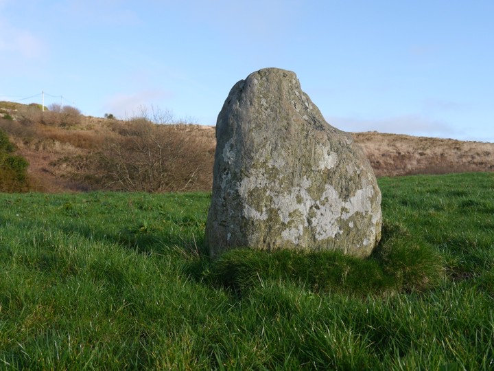
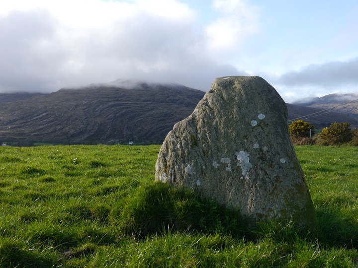
Small stone situated in a field in the lanes just West of Adrigole. A fieldgate gives easy access.
The stone is just under a metre high and is aligned ENE-WSW.
There are fine views over Bantry Bay and towards Hungry Hill.
Comments (0)
|
Add a comment
|
Permalink
Posted by
Meic
26th February 2012ce


 Posted by Meic