|
|

|
|
Dorchester CursusCursus
|
||||||||||||||||||||||||
|
|
|
Images (click to view fullsize) |
|
|
Miscellaneous |
|
|
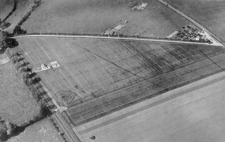
Details of site on Pastscape A Neolithic cursus at Dorchester on Thames, largely known as cropmarks and partly excavated in 1947-52 and 1981. The cursus ditches were first recorded as cropmarks in 1927 (Crawford 1927) and again in the 1930s before being tentatively included in the first discussions of "cursus" monuments in the late 1930s and 1940s. Much of its course has been destroyed by gravel quarrying and the construction of the Dorchester bypass. Excavations between 1947 and 1952 focused on the northern part of the cursus and in particular on the monuments beside and within it (see Atkinson et al 1951; Whittle et al 1992), while work in 1981 in advance of the Dorchester bypass included some work at the southeastern end (see Whittle et al 1981). The significance of the cursus and the broad sequence of monument construction and use have been discussed on numerous occasions, most notably by Bradley and Chambers (1988), Whitle et al (1992) and Loveday (1999) while the dating of the cursus itself is considered by Barclay and Bayliss (1999). Whittle et al described the complex as displaying "arguably the greatest diversity of monuments and the longest sequence of development of all the Upper Thames complexes. More widely it can be compared with concentrations of monuments in Wessex". Note that Atkinson numbered the monuments examined in 1947-1952 with Roman numerals (the cursus is Site III) while those excavated in 1981 were asigned numbers 1 to 4. The only potential confusion arises in dealing with site I and site 1. The cursus comprised two broadly parallel ditches circa 60 metres apart, running for at least 1600 metres in a more-or-less northwest-southeast direction. The cursus and its associated complex of monuments (see associated records) run across the neck of a strip of land defined by a bend in the River Thames and a tributary, the Thame. No northwest terminal has been identified, although Atkinson has noted some indistinct cropmarks (in Whittle et al 1992, p159) which might at least account for the alignment of the cursus. At the southeast end, there appears to have been no formal terminal. Instead, the cursus incorporated an earlier D-Shaped enclosure ("Site 1" - SU 59 SE 163) although Loveday (1999) has argued that this enclosure did not actually exist. The cursus at this end appears to taper slightly. It is presumed that the southern ditch abuts the enclosure ditch, while the northern cursus ditch appears to run parallel with and to the north of the enclosure ditch. Although cropmarks continue to the southeast on both sides of the Thame, there is nothing that could be regarded as a continuation of the cursus. Whittle et al did note the presence of a concentration of flint surviving as a surface scatter in the area between the southeastern end of the cursus and the Thame. Several interruptions of varying lengths are visible along both ditches of the cursus. The cursus also changes direction slightly along its course. The north ditch changes alignment once and the south ditch twice, although these changes in direction do not coincide. Bradley and Chambers (1988) suggested that the monuments preceding the cursus where aligned on the minor moonrise around the time of midsummer sunset, while the northwestern segment of the cursus represented a shift in alignment towards midsummer sunset itself, and suggested that this might be representative of a general shift in beliefs focused on the moon to a greater concern with the sun. The problems with this interpretation are the fact that they noted only one change in alignment of the cursus overall, while it is also clear that half of the cursus actually retained the alignment of the earlier monuments. In addition to Site 1, the cursus is also pre-dated by the long enclosure known as SIte VIII (SU 59 NE 4). Bradley and Chambers suggested that some other monuments may also pre-date it, though Whittle et al suggest otherwise on the basis of dating evidence. The southern cursus actually cuts across the "Site VIII" enclosure, the cursus ditch passing through the enclosure's southeast entrance causeway (at which point the cursus ditch is also interrupted by a causeway). The best dating evidence for the cursus comes from this area. A polished flint axe came from the primary fill, a lozenge shaped flint arrowhead came from the bottom of the secondary silting, and sherds of both Ebbsfleet Ware and Beaker were reported from the upper fills. An antler from the primary fill has been dated to 3380-2920 BC (calibrated), though whether this genuinely dates the cursus construction is open to debate. However, dating evidence recovered from earlier and later monuments in the complex supports a broad 2nd half of the 4th millennium BC date, in line with cursus monuments generally. Excavations of the cursus ditch have generally been narrow cuttings or small stretches of ditch, although a reasonable length within Site VIII was examined. Surviving section drawings show the southern cursus ditch to have been cut up to 2.4m wide and 1.2m deep into the gravel. The surviving sections show a symmetrical silting pattern, although Atkinson refered to evidence for the presence of an internal bank. The ditches appear to have silted up naturally. Whittle et al suggested that certain aspects of the cursus layout - for example the open ends, the changes in alignment, the gaps along the ditches - hinted at episodic construction, perhaps in several stages. Atkinson noted an artifical interruption in the southern ditch caused by deliberate backfilling of the ditch. While this might support the idea of episodic activity, the location of this artificial causeway is not located. In contrast, Loveday argues that the cursus should be regarded "as the product of a single act" (5b, 8-12) The Cursus West ditch passes through the probable Long Barrow at "Site VIII" (SU 571955) and is secondary to it. A quantity of Ebbsfleet or Peterborough pottery was found in the middle filling of the Cursus ditch at this point. (1) The East ditch of the Cursus was later than the enclosure and earlier than the "droveway" at "SiteIX" (SU 570958), which yielded Abingdon Neo. pottery. (2) Two causeways across W. ditch, one natural and one artificial, found near "Sites V & VI" but no dating material, during 1947. (3) The Cursus, as shewn on A.P.s. extends from SU 5690 9585 to SU 5781 9509 with a possible extension to SU 5815 9481. (4) Information as in T.I. A polished flint axe and a a leaf-shaped arrowhead were found in the primary silting of the ditch, and pottery of Ebbsfleet type in the upper silting. (5) Excavations in advance of the Dorchester by pass examined the south-eastern terminal. A flint arrowhead was the only datable artefact found. A central entrance was found at the terminus. (6) -------------------------------------------------------------------------------- SOURCE TEXT -------------------------------------------------------------------------------- (1) Oxfordshire Architectural and Historical Society Oxoniensia [RJC Atkinson. Archaeological Notes] 13, 1948 Page(s)66 (2) Oxfordshire Architectural and Historical Society Oxoniensia [RJC Atkinson. Archaeological Notes] 13, 1948 Page(s)67 (3) Oxfordshire Architectural and Historical Society Oxoniensia [Archaeological Notes] 11-12, 1947 Page(s)164 (4) Field Investigators Comments F1 DT 01-AUG-51 (4a) Aerial photograph - O.G.S.Crawford's Air Photos. (5) Field Investigators Comments F2 FAH 18-SEP-52 (5b) by R J C Atkinson, C M Piggott and N K Sandars 1951 Excavations at Dorchester, Oxon: first report. Sites I, II, IV, V and VI, with a chapter on henge monuments Page(s)60-3 (6) edited by Andrew Pike 1992 South Midlands Archaeology [Newsletter of the CBA South Midlands Group 9] Council for British Archaeology Group 9: South Midlands archaeology newsletterno 1 (1971) - 12, 1982 Page(s)144-5 (7) RCHME/EH Aerial Photographers Comment Fiona Small/12-MAY-1994/RCHME: Thames Valley NMP (8) Oxford journal of archaeology Bradley R, Chambers R. A New Study of the Cursus Complex at Dorchester on Thammes. 7, 1988 Page(s)271-89 (9) Proceedings of the Prehistoric Society - Whittle A et al. Excavations in the Neolithic and Bronze Age Complex at Dorchester-on-Thames, Oxfordshire, 1947-1952 and 1981. 58, 1992 Page(s)143-201 (10) A Barclay, J Harding (eds) 1999 Pathways and Ceremonies: the cursus monuments of Britain and Ireland Barclay A, Bayliss A. Cursus monuments and the radiocarbon problem. Page(s)11-30 (11) A Barclay, J Harding (eds) 1999 Pathways and Ceremonies: the cursus monuments of Britain and Ireland Loveday, R. Dorchester-on-Thames - ritual complex or ritual landscape? Page(s)49-63 (12) Antiquity Publications Limited Antiquity - Crawford, OGS. Air-Photographs near Dorchester, Oxon 1, 1927 Page(s)469-474 |
 Posted by Chance
5th February 2012ce |