The locality lies to the west of, and yet quite close to the wild and picturesque neighbourhood of Forkill, just on the west verge of the steep and rocky hills that stand out like sentinels before the great round mass of Slieve Gullion, which, 1893 feet in height, towers up grandly above them all, at a distance of only four miles.
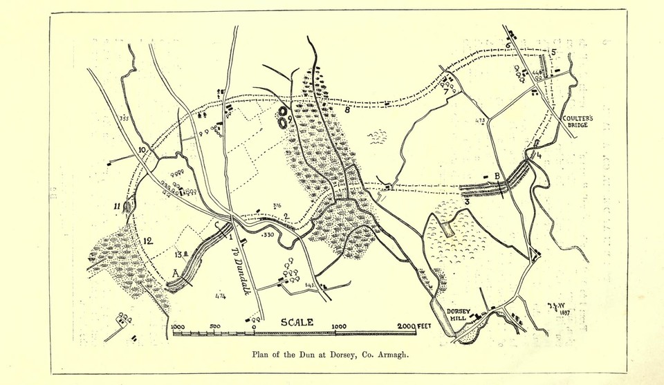
[…] Traces of the “walls” are found from 10 to 11 [on the diagram]. At 11 there is a small bit of one of the ramparts still left. It is to be observed that from 9 to 11 the line of the “walls” curves gently to the south. From 11 the “walls are distinctly marked along the edge of a very deep bog where large quantities of turf are now each year, as they no doubt have for centuries been, prepared for fuel.
In this bog the old 6-inch Ordnance Survey Map once more sets out a short line of “piles”. And the natives tell of their having found oak “stakes” or “stabs” here with “collars” of oak fitted to them, and that “this was the way out to the country, and away through Ireland.” On the 6-inch Ordnance Survey Map, dated 1836; at this spot is a bit of “piles” set out into the bog at right angles to the line of the “walls.”
[…] On the descent of the “walls” towards 1, at the “Five roads,” the fosses are deep and well preserved, and the whole is studded with very old “fairy thorns.”
The inhabitants of the district hold that this part of the fortifications is the peculiar haunt of fairies; they assured us that “it would be unlucky to cut down one of the thorns or so much as even a branch, and when the bridge below was being fixed three years ago Brian K—would not let one branch be touched, and his son Owen would not lend his saw to cut a bit of one that was in the men’s way. Nobody would take a chip off them thorns, and look how gay they be, and mind you, every one of them is hundreds and hundreds of years old.
“One night I sat up to watch the turf in the bog that was a stealing, and I saw and heard – but I would not do it again for all the turf that ever were. I sat among the bushes beyont there, and I will not tell why I wouldn’t do it again. One evening we saw a funeral coming along the road from Dundalk, and it went up the rampart above there among the thorns, and they laid the corpse down and dug a grave, and put it in. The police got to hear of it, and they come and searched and searched the place everywhere but not a trace of anything did they see or find. And why should they, for sure it was not earthly.
“A girl who was herding the cows, and was at her sewing as she did so, saw a boy, her cousin, come along towards a gap in the fence near her. She bent her head a moment while hiding her sewing in her dress, and when she looked up, the boy was gone, and though she ran everywhere and called his name he was not there.”
We asked a boy who happened to be herding cattle near the bog, had he heard or ever seen a fairy. “I’ve heard of them, but I never saw one myself.” “Would you like to be out at dark on the old rampart?” we inquired. “I would not like to be there by myself,” was his reply.
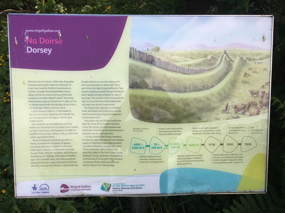
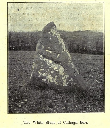
Within the dun, on the highest point of this hill at 13, is a “Standing stone,” 5 feet high, having in it several deep and curious marks like the impressions of a huge finger, which were pointed out to us as “Caliagh Beri’s finger-marks.” The stone is locally known as “the White Stone of Caliagh Beri,” by whom the local tradition relates it to have been thrown into its present position from her lake on the top of Slieve Gullion. From the Journal of the Royal Society of Antiquaries of Ireland, 1898: The Dun at Dorsey, Co. Armagh by Rev. Henry William Lett.
According to this page the stone used to be whitewashed each year.
|
 Posted by Rhiannon
31st January 2016ce
Edited 31st January 2016ce |

 Maps / Plans / Diagrams: