The Modern Antiquarian
Log in
|
Register
Home
Latest Posts
Forums
Maps
Help
Browse Sites
News
Blog
Contributors
The Books
Select
-
Belgium
Denmark
Eire
France
Germany
Greece
Italy
The Netherlands
Norway
Portugal
Republic of Malta
Spain
Sweden
Switzerland
United Kingdom
County Dublin
Westown North
Round Barrow(s)
Westown North (Round Barrow(s)) on The Modern Antiquarian, the UK & Ireland's most popular megalithic community website. 1 image, plus information on many more ancient sites nearby and across the UK & Ireland.
Image © ryaner
Nearest Town:
Garristown (5km WSW)
OS Ref (IE):
O122602 /
Sheet: 43
Latitude:
53° 34' 46.77" N
Longitude:
6° 18' 20.82" W
Added by
ryaner
Images (1)
0 discussions
Start a topic
Show |
Hide
Web searches for Westown North
Flickr
Google
Google Images
The Megalithic Portal
Bing
Stone Pages
Wikipedia
Show map
(inline Google Map)
- Sites within 20 km -
-
Fourknocks (2.14km NW) (5 posts)
Fourknocks (2.3km WNW) (35 posts)
Hodgetown (2.4km NNE) (0 posts)
Damastown (2.61km SSE) (3 posts)
Mallahow (2.7km SSE) (0 posts)
Micknanstown (2.8km WNW) (2 posts)
Tullog (3.15km NE) (0 posts)
Kichenstown (3.21km E) (0 posts)
Knockbrack (3.22km E) (1 post)
Knockbrack (3.32km E) (0 posts)
Heathtown Mound (3.38km WNW) (4 posts)
Heathtown Henge II (3.46km WNW) (5 posts)
Herbertstown (3.47km NNW) (4 posts)
Heathtown Henge I (3.74km WNW) (0 posts)
Hollywood Great (3.93km ESE) (1 post)
Nags Head (3.93km ESE) (0 posts)
Greenanstown (4.21km NNW) (4 posts)
Garristown (5.27km WSW) (0 posts)
Mullahteelin (6.1km NNW) (0 posts)
Moorepark (6.66km W) (0 posts)
Balgeeth (6.81km W) (2 posts)
Inch (7.65km ENE) (0 posts)
Piercetown (7.87km WSW) (0 posts)
Newtown (7.88km WSW) (0 posts)
Balrothery (8.14km ENE) (7 posts)
Hilltown Little (8.25km WNW) (0 posts)
Roadmain (8.37km W) (0 posts)
Gormanston (8.47km NE) (6 posts)
Gormanston Beach (8.82km NE) (3 posts)
Primatestown (8.87km WSW) (0 posts)
Boolies Great (9.06km W) (0 posts)
Bellewstown (9.3km WNW) (5 posts)
Bremore (9.37km NE) (36 posts)
Skidoo (9.41km SE) (0 posts)
Windmill Hill (10.24km WSW) (0 posts)
Grange (10.3km E) (11 posts)
Kilbrew (10.51km WSW) (3 posts)
Lusk (10.63km E) (2 posts)
Barnageeragh (10.69km ENE) (2 posts)
Balcunnin (10.78km E) (3 posts)
Ho Stone, Balcunnin (10.84km E) (2 posts)
Gaulstown (11.32km W) (3 posts)
Laytown (An Inse) (11.56km NNE) (6 posts)
Bey More (13km NNW) (0 posts)
Longford (13.34km WNW) (0 posts)
Kilcrea (14.33km ESE) (0 posts)
Drogheda (14.71km NNW) (0 posts)
Danestown Ringfort (15.13km W) (4 posts)
Drumanagh (15.46km E) (0 posts)
Rush (15.53km E) (7 posts)
Trevet (15.92km WSW) (3 posts)
Newgrange Tumulus B (15.97km WNW) (3 posts)
Hedgerow Stone (16.19km WNW) (2 posts)
Baltray (16.29km N) (12 posts)
Newgrange Tumulus A (16.38km WNW) (3 posts)
Dowth Mound III (16.44km WNW) (0 posts)
Dowth II (16.46km WNW) (1 post)
Dowth Henge (16.5km WNW) (10 posts)
Dowth Mound I (16.55km WNW) (0 posts)
Dowth Mound II (16.56km WNW) (0 posts)
Cloghalea (16.7km NW) (6 posts)
Oldbridge (16.75km NW) (7 posts)
Dowth (16.75km WNW) (4 posts)
Dowth I (16.76km WNW) (68 posts)
Newgrange Cursus (16.81km WNW) (2 posts)
Collierstown (16.84km WSW) (0 posts)
Newgrange (16.98km WNW) (128 posts)
The Great Circle (17.01km WNW) (23 posts)
Newgrange Standing Stone C (17.01km WNW) (6 posts)
Newgrange K & L (17.08km WNW) (10 posts)
Townley Hall Barrow (18.17km NW) (0 posts)
Knowth (18.2km WNW) (120 posts)
Rath Lugh (18.26km W) (4 posts)
Rossnaree (18.27km WNW) (3 posts)
Littlegrange (18.35km WNW) (9 posts)
Townley Hall Souterrain (18.42km NW) (0 posts)
Lismullin (18.67km W) (8 posts)
Gerrardstown (18.68km W) (0 posts)
Monknewtown II (19.03km WNW) (3 posts)
Monknewtown Pond (19.12km WNW) (4 posts)
Monknewtown (19.15km WNW) (2 posts)
Cabragh (19.32km W) (0 posts)
Blundelstown (19.36km W) (0 posts)
Realtoge (19.44km W) (4 posts)
Garlagh (19.55km W) (0 posts)
Clonardran (19.57km W) (0 posts)
Painestown (19.57km W) (0 posts)
Corduff (19.75km SSW) (3 posts)
Johnstown (19.76km WNW) (0 posts)
Rath Maeve (19.91km WSW) (10 posts)
- Add -
-
Add news
Add an image
Add fieldnotes
Add folklore
Add miscellaneous
Add a link
-
Add a site
Add a nearby facility
Add an alternative name/spelling
Images
(click to view fullsize)
Add an image
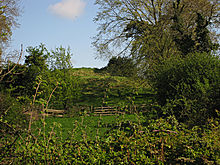 Image © ryaner

