The Modern Antiquarian
Log in
|
Register
Home
Latest Posts
Forums
Maps
Help
Browse Sites
News
Blog
Contributors
The Books
Select
-
Belgium
Denmark
Eire
France
Germany
Greece
Italy
The Netherlands
Norway
Portugal
Republic of Malta
Spain
Sweden
Switzerland
United Kingdom
County Tipperary
Cahernahallia
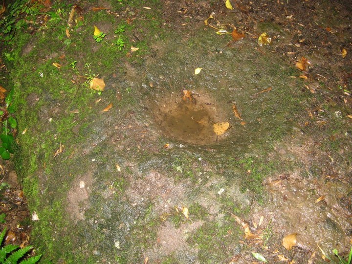
Cahernahallia
Bullaun Stone
Cahernahallia (Bullaun Stone) on The Modern Antiquarian, the UK & Ireland's most popular megalithic community website. 1 image, plus information on many more ancient sites nearby and across the UK & Ireland.
Image © Bawn79 © 2009
Nearest Town:
Cappamore (9km W)
OS Ref (IE):
R856484 /
Sheet: 66
Latitude:
52° 35' 12.45" N
Longitude:
8° 12' 44.94" W
Added by
bawn79
Images (1)
0 discussions
Start a topic
Show |
Hide
Web searches for Cahernahallia
Flickr
Google
Google Images
The Megalithic Portal
Bing
Stone Pages
Wikipedia
Show map
(inline Google Map)
- Sites within 20 km -
-
Cahernahallia (0km N) (2 posts)
Kilmoylan Upper (2.52km W) (3 posts)
Gortnageragh (3.8km N) (2 posts)
Lackanagoneeny (5.21km NW) (4 posts)
Foilaclug (6.35km ENE) (3 posts)
Foilycleara (7.39km N) (3 posts)
Garracummer (8.34km NE) (8 posts)
Blackstairs (9.18km NE) (4 posts)
Blackstairs (9.18km NE) (3 posts)
Tuogh (9.19km W) (0 posts)
Aughsullish SW (9.23km N) (6 posts)
Aughsullish NW (9.35km N) (1 post)
Knockshanbrittas (A) (9.36km N) (6 posts)
Liseen (9.42km WSW) (3 posts)
Knocksefin (9.58km WSW) (1 post)
Glencarbry (9.77km ENE) (1 post)
Rathneaveen (9.78km SE) (2 posts)
Rathneaveen (10.32km SE) (2 posts)
Shanballyedmond (10.38km NNW) (17 posts)
Knocsefin (10.84km WSW) (3 posts)
Sarsfields Rock (10.87km SW) (3 posts)
Longstone (10.91km SW) (1 post)
Longstone (10.91km SW) (8 posts)
Longstone (10.91km SW) (3 posts)
Cnoc Greine (11.03km WSW) (3 posts)
Springfield (11.38km SSE) (2 posts)
Baurnadomeeny (11.62km NNW) (38 posts)
Goulmore (11.69km N) (4 posts)
Loughbrack (11.92km NNE) (11 posts)
Baurnadomeeny (11.93km NNW) (6 posts)
Reardnogy More (11.93km NNW) (3 posts)
Baurnadomeeny (12.11km NNW) (4 posts)
Donaskeagh (12.29km ESE) (2 posts)
Knocknabansha (12.77km NNE) (5 posts)
Glenbane (13.22km SSW) (1 post)
Knockmaroe (13.35km NE) (3 posts)
Ballyconry (13.42km S) (2 posts)
Ballyconry (13.54km S) (6 posts)
Longstone (13.56km WSW) (2 posts)
Mauherslieve (13.6km N) (1 post)
Mauherslieve (13.6km N) (6 posts)
Ballynilard (13.63km SSE) (4 posts)
Lattin (13.65km SSW) (3 posts)
Knockroe (13.69km SW) (1 post)
Reisk (13.8km NNE) (1 post)
Garranbane (13.88km WNW) (5 posts)
Knockcurraghbola Crowlands (west) (13.89km NE) (8 posts)
Knockcurraghbola Crowlands (east) (13.91km NE) (2 posts)
Knockcurraghbola Crowlands (central) (13.95km NE) (2 posts)
Knockcurraghbola Crowlands (13.99km NE) (1 post)
Clonpet (14.05km SSE) (1 post)
Graniera (14.12km NE) (3 posts)
Lattin (14.18km SSW) (3 posts)
Knockcurraghbola Crowlands standing stone (14.19km NE) (3 posts)
Doonglara (Glenbrohane) (14.91km W) (1 post)
Knockballynoe (15.16km ESE) (2 posts)
Kilfeakle Churchquarter (15.24km ESE) (3 posts)
Scraggeen (15.37km WNW) (2 posts)
Knockballynoe (15.41km ESE) (2 posts)
Cromwell Hill (15.73km SW) (7 posts)
Knockeen (15.77km W) (1 post)
Shevry (15.8km NE) (8 posts)
Knockcurraghbola Commons (15.8km NE) (22 posts)
Shevry (15.87km NE) (1 post)
Cloonyconry More (15.96km SW) (4 posts)
Cureeny Commons (16.51km N) (17 posts)
Toorfiba (17.19km NE) (3 posts)
Rock an Tarbh (17.27km SSE) (3 posts)
Cooga (17.43km NE) (4 posts)
Cooga (17.43km NE) (2 posts)
Glastrigan (17.56km NE) (13 posts)
Rootiagh (17.6km WSW) (1 post)
Shrough (17.82km S) (16 posts)
Lodge (17.83km SW) (4 posts)
Ballagh II (17.9km SE) (1 post)
Rootiagh (17.93km WSW) (3 posts)
Ballagh I (17.95km SE) (3 posts)
Hospital (18.17km SW) (2 posts)
Gortavoher (North) (18.24km SSE) (4 posts)
Coolalough (18.55km SW) (5 posts)
Gortavoher (18.67km SSE) (1 post)
Corderry (18.81km S) (8 posts)
Ballynamona (18.84km WSW) (4 posts)
Coolalough (19.07km SW) (2 posts)
Cooneen (19.12km N) (3 posts)
Castlefarm (19.16km SW) (4 posts)
Foilnamuck (19.18km N) (5 posts)
Inch St. Lawrence (19.63km W) (7 posts)
Skahard (19.66km W) (3 posts)
Foilnamuck (19.66km N) (10 posts)
Knockroe (19.73km WSW) (7 posts)
Cloghaunainey (19.88km WSW) (1 post)
Knockroe (19.93km WSW) (2 posts)
Bauraglanna (19.95km NNW) (9 posts)
Knockroe (19.96km WSW) (3 posts)
Ballybricken East (19.97km WSW) (4 posts)
Ardmayle (19.97km E) (6 posts)
- Add -
-
Add news
Add an image
Add fieldnotes
Add folklore
Add miscellaneous
Add a link
-
Add a site
Add a nearby facility
Add an alternative name/spelling
Images
(click to view fullsize)
Add an image
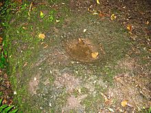 Image © Bawn79 © 2009