The Modern Antiquarian
Log in
|
Register
Home
Latest Posts
Forums
Maps
Help
Browse Sites
News
Blog
Contributors
The Books
Select
-
Belgium
Denmark
Eire
France
Germany
Greece
Italy
The Netherlands
Norway
Portugal
Republic of Malta
Spain
Sweden
Switzerland
United Kingdom
County Wexford
Ballinacarrig
Standing Stones
Ballinacarrig (Standing Stones) on The Modern Antiquarian, the UK & Ireland's most popular megalithic community website. 1 image, plus information on many more ancient sites nearby and across the UK & Ireland.
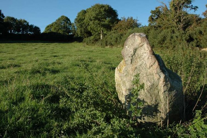
Image © ryaner
Nearest Town:
Arklow (13km N)
OS Ref (IE):
T198614 /
Sheet: 62
Latitude:
52° 41' 26.05" N
Longitude:
6° 13' 40.76" W
Added by
FourWinds
Images (1)
0 discussions
Start a topic
Show |
Hide
Web searches for Ballinacarrig
Flickr
Google
Google Images
The Megalithic Portal
Bing
Stone Pages
Wikipedia
Show map
(inline Google Map)
- Sites within 20 km -
-
Tara Hill (1.14km NE) (4 posts)
Tara Hill Cairn 2 (1.27km NE) (3 posts)
Kilcavar (1.41km NNW) (0 posts)
Tinnock (3.53km WNW) (0 posts)
Lackan (5.94km W) (0 posts)
Coolintaggarthill (6.6km W) (0 posts)
Bolany (9.87km W) (0 posts)
Croghan Middle (10.99km WNW) (4 posts)
Slievefoore (12.01km NW) (10 posts)
Clonamore Upper (12.65km W) (0 posts)
Foxcover (12.99km W) (0 posts)
Ballinclare (13.08km WSW) (4 posts)
Monbay Upper (13.49km WSW) (0 posts)
Buckstown (13.89km W) (0 posts)
Shrule (14.42km WSW) (0 posts)
Sheepwalk (15.46km N) (0 posts)
Carrigroe Hill (15.88km SW) (0 posts)
Carnew (17.24km W) (3 posts)
Kilcoilshy (18.01km SW) (0 posts)
Ballygahan Upper (19.44km NNW) (4 posts)
Preban (19.78km WNW) (10 posts)
- Add -
-
Add news
Add an image
Add fieldnotes
Add folklore
Add miscellaneous
Add a link
-
Add a site
Add a nearby facility
Add an alternative name/spelling
Images
(click to view fullsize)
Add an image
 Image © ryaner