The Modern Antiquarian
Log in
|
Register
Home
Latest Posts
Forums
Maps
Help
Browse Sites
News
Blog
Contributors
The Books
Select
-
Belgium
Denmark
Eire
France
Germany
Greece
Italy
The Netherlands
Norway
Portugal
Republic of Malta
Spain
Sweden
Switzerland
United Kingdom
County Tipperary
Crohane Lower
Standing Stone / Menhir
Crohane Lower (Standing Stone / Menhir) on The Modern Antiquarian, the UK & Ireland's most popular megalithic community website. 1 image, 1 fieldnote, plus information on many more ancient sites nearby and across the UK & Ireland.
Image © Bawn79 © 2009
Nearest Town:
Gorey (18km NW)
OS Ref (IE):
S268457 /
Sheet: 67
Latitude:
52° 33' 43.41" N
Longitude:
7° 36' 17.16" W
Added by
bawn79
Images (1)
Fieldnotes (1)
0 discussions
Start a topic
Show |
Hide
Web searches for Crohane Lower
Flickr
Google
Google Images
The Megalithic Portal
Bing
Stone Pages
Wikipedia
Show map
(inline Google Map)
- Sites within 20 km -
-
Knocknagapple (2.78km NW) (0 posts)
Waterloo Hill (5.09km WNW) (1 post)
Waterloo Hill (5.23km WNW) (2 posts)
Drangan (5.35km SSE) (0 posts)
Buffanagh (8.17km WSW) (2 posts)
Warhouse Hill (8.54km NE) (2 posts)
Foilacamin (8.94km N) (2 posts)
Clonamondra (9.36km N) (0 posts)
Derrynaflan (9.46km W) (4 posts)
Crab (10.1km N) (0 posts)
Cloran Old (10.99km S) (3 posts)
Sheegouna (14.46km SE) (6 posts)
Slievenamon (15.28km SSE) (7 posts)
Ballinree (16.54km W) (1 post)
Ballinree (16.56km W) (2 posts)
Ballinree (16.56km W) (3 posts)
Templemichael (17km ESE) (2 posts)
Mallardstown (17.35km E) (0 posts)
Ballinvir (17.66km ESE) (2 posts)
Rosegreen (18.41km WSW) (4 posts)
Jamestown (18.5km S) (3 posts)
Temple-etney (18.5km S) (1 post)
Corralough (18.64km WSW) (2 posts)
Ballypatrick (18.7km SSE) (3 posts)
Rathealy (18.76km NE) (5 posts)
Borrismore Tomb (19.11km N) (0 posts)
Borrismore (19.35km N) (6 posts)
Kiltrassy (19.47km ESE) (3 posts)
Knockroe (Kells By., Killamery ED) (19.47km ESE) (3 posts)
Rathealy (19.66km NE) (3 posts)
Rath na Drinne (19.86km WSW) (4 posts)
- Add -
-
Add news
Add an image
Add fieldnotes
Add folklore
Add miscellaneous
Add a link
-
Add a site
Add a nearby facility
Add an alternative name/spelling
Images
(click to view fullsize)
Add an image
Fieldnotes
Add fieldnotes
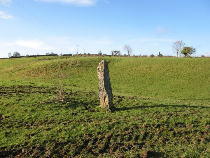
This standing stone isnt marked on the OS map. It is about 1.2 m high and is located to the east of the town of Killenaule in Tipp.
There is a holy well to the east in the same townland which I didnt investigate at the time.
Comments (0)
|
Add a comment
|
Permalink
Posted by
bawn79
20th January 2009ce