The Modern Antiquarian
Log in
|
Register
Home
Latest Posts
Forums
Maps
Help
Browse Sites
News
Blog
Contributors
The Books
Select
-
Belgium
Denmark
Eire
France
Germany
Greece
Italy
The Netherlands
Norway
Portugal
Republic of Malta
Spain
Sweden
Switzerland
United Kingdom
County Meath
Boyne Valley Complex
Newgrange
Hedgerow Stone
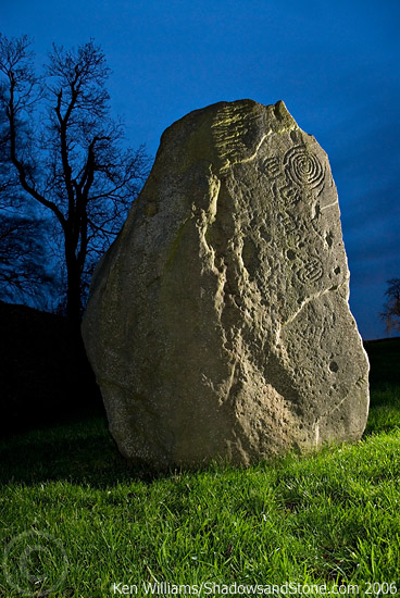
Standing Stones
Hedgerow Stone (Standing Stones) on The Modern Antiquarian, the UK & Ireland's most popular megalithic community website. 2 images, plus information on many more ancient sites nearby and across the UK & Ireland.
Image © Ken Williams/ShadowsandStone.com
This site is of disputed antiquity. If you have any information that could help clarify this site's authenticity, please post below or
leave a post in the forum
.
Nearest Town:
Duleek (5km SE)
OS Ref (IE):
O016725 /
Sheet: 43
Latitude:
53° 41' 32.27" N
Longitude:
6° 27' 42.34" W
Added by
FourWinds
Images (2)
1 discussion topic
Start a topic
Show |
Hide
Web searches for Hedgerow Stone
Flickr
Google
Google Images
The Megalithic Portal
Bing
Stone Pages
Wikipedia
Show map
(inline Google Map)
- Sites within 20 km -
-
Newgrange Tumulus B (0.3km S) (3 posts)
Newgrange Tumulus A (0.41km WSW) (3 posts)
Newgrange Cursus (0.73km W) (2 posts)
Dowth Mound II (0.89km NNE) (0 posts)
Newgrange (0.94km W) (128 posts)
Dowth Mound III (1km NE) (0 posts)
The Great Circle (1.02km W) (23 posts)
Newgrange Standing Stone C (1.02km W) (6 posts)
Newgrange K & L (1.11km W) (10 posts)
Dowth I (1.47km NNE) (68 posts)
Dowth (1.48km NE) (4 posts)
Dowth II (1.97km NE) (1 post)
Dowth Mound I (2.05km NE) (0 posts)
Knowth (2.17km W) (120 posts)
Dowth Henge (2.47km NE) (10 posts)
Cloghalea (2.75km NE) (6 posts)
Longford (2.91km SE) (0 posts)
Monknewtown Pond (3.04km NW) (4 posts)
Monknewtown II (3.1km NNW) (3 posts)
Monknewtown (3.16km NW) (2 posts)
Littlegrange (3.27km N) (9 posts)
Rossnaree (3.54km WSW) (3 posts)
Townley Hall Souterrain (3.95km NNE) (0 posts)
Townley Hall Barrow (4.33km NNE) (0 posts)
Oldbridge (4.75km NE) (7 posts)
Gallows Hill (5.07km W) (0 posts)
Stanley Hill (5.14km W) (0 posts)
Johnstown (5.41km WSW) (0 posts)
Mellifont (5.51km NNW) (0 posts)
Hill of Slane Souterrain (5.57km W) (0 posts)
Hill of Slane Barrow (6.15km W) (1 post)
Painestown (6.68km WSW) (0 posts)
Bellewstown (6.99km ESE) (5 posts)
Gaulstown (7.11km SSE) (3 posts)
Rathmaiden (7.28km WNW) (0 posts)
Hilltown Little (8.13km ESE) (0 posts)
Bey More (8.18km ENE) (0 posts)
Boolies Great (8.24km SE) (0 posts)
Drogheda (8.26km ENE) (0 posts)
Danestown Ringfort (8.7km SSW) (4 posts)
Gernonstown (8.76km W) (2 posts)
Gernonstown (9.42km W) (5 posts)
Kilbride (Talbotstown Lower By.) (9.43km N) (6 posts)
Realtoge (9.69km SW) (4 posts)
Kingstown & Carnuff Great (9.71km WSW) (1 post)
Davidstown Barrow (9.72km W) (0 posts)
Mullagharoy (10.39km WNW) (4 posts)
Fieldstown (10.41km NE) (7 posts)
Gerrardstown (10.51km SW) (0 posts)
Balgeeth (10.73km SE) (2 posts)
The Stuck Stone (10.77km WNW) (0 posts)
Paddock (11.11km NNE) (15 posts)
Mount Oriel (11.3km NW) (3 posts)
Stackallan (11.45km W) (2 posts)
Slieve Beagh (11.5km WNW) (13 posts)
Dunmore (11.52km NW) (0 posts)
Moorepark (11.87km SE) (0 posts)
Mullahteelin (11.9km E) (0 posts)
Piperstown (12.15km NE) (1 post)
Roadmain (12.28km SSE) (0 posts)
Mullagha (12.29km W) (6 posts)
Heathtown Henge I (12.48km ESE) (0 posts)
Belpatrick (12.59km NW) (0 posts)
Greenanstown (12.59km ESE) (4 posts)
Clonardran (12.7km SW) (0 posts)
Piercetown (12.77km SSE) (0 posts)
Heathtown Henge II (12.77km ESE) (5 posts)
Heathtown Mound (12.85km ESE) (4 posts)
Mullaghash (12.88km NW) (2 posts)
Mullaghash (12.88km NW) (3 posts)
Drumshallon (12.88km NE) (0 posts)
Milltown (13.19km NE) (0 posts)
Herbertstown (13.27km ESE) (4 posts)
Micknanstown (13.42km ESE) (2 posts)
Garlagh (13.43km SW) (0 posts)
Rathbran More (13.47km WNW) (6 posts)
Rath Lugh (13.56km SW) (4 posts)
Lismullin (13.63km SW) (8 posts)
Laytown (An Inse) (13.9km E) (6 posts)
Fourknocks (13.91km ESE) (35 posts)
White Mountain (14.06km NW) (0 posts)
Corracon (14.1km NW) (0 posts)
Fourknocks (14.12km ESE) (5 posts)
Blundelstown (14.13km SW) (0 posts)
Termonfeckin (14.15km ENE) (0 posts)
Baltray (14.23km ENE) (12 posts)
Primatestown (14.3km SSE) (0 posts)
Collierstown (14.33km SSW) (0 posts)
Rathkenny (14.64km W) (8 posts)
Windmill Hill (14.69km SSE) (0 posts)
Kilbrew (14.98km SSE) (3 posts)
Hodgetown (15.05km ESE) (0 posts)
Cabragh (15.25km SW) (0 posts)
Garristown (15.36km SE) (0 posts)
Newtown (15.41km SSE) (0 posts)
Tullog (15.69km ESE) (0 posts)
The Banqueting Hall (15.72km SW) (10 posts)
The Sloping Trenches (15.76km SW) (3 posts)
Grainne's Enclosure (15.76km SW) (6 posts)
Knockdinnin (15.8km N) (0 posts)
Ardsallagh (15.9km WSW) (2 posts)
Churchyard Stones (15.9km SW) (12 posts)
Dardisrath (15.98km ENE) (0 posts)
The Barrows (16.02km SW) (0 posts)
Rath of Synods (16.02km SW) (7 posts)
Cormac's House (16.1km SW) (9 posts)
The Mound of Hostages (16.1km SW) (28 posts)
Lia Fail (16.1km SW) (23 posts)
The King's Seat (16.1km SW) (12 posts)
The Royal Enclosure (16.1km SW) (2 posts)
Rath Laoghaire (16.18km SW) (2 posts)
Westown North (16.19km ESE) (1 post)
Roestown (16.25km NNW) (0 posts)
Purcellstown (16.25km NW) (0 posts)
Blakestown (16.26km NW) (0 posts)
Walshestown (16.38km NE) (0 posts)
Knock (16.4km W) (2 posts)
Hurlstone (16.65km NW) (6 posts)
South Stone (16.72km NNW) (2 posts)
Barnaveddoge Mound (16.83km NNW) (0 posts)
North Stone (16.9km NNW) (0 posts)
Rath Maeve (16.93km SW) (10 posts)
Gormanston (17.3km E) (6 posts)
Mullameelan (17.42km NW) (0 posts)
Trevet (17.51km SSW) (3 posts)
Gormanston Beach (17.65km E) (3 posts)
Arch Hall (17.81km W) (6 posts)
Skeaghmore (17.89km NNE) (0 posts)
Labanstown (18.22km NE) (0 posts)
Damastown (18.42km ESE) (3 posts)
Mallahow (18.44km ESE) (0 posts)
Kichenstown (18.7km ESE) (0 posts)
Knockbrack (18.84km ESE) (0 posts)
Knockbrack (18.97km ESE) (1 post)
Bremore (19.07km E) (36 posts)
Clogher Head (19.52km NE) (1 post)
Dunsany (19.97km SW) (4 posts)
- Add -
-
Add news
Add an image
Add fieldnotes
Add folklore
Add miscellaneous
Add a link
-
Add a site
Add a nearby facility
Add an alternative name/spelling
Images
(click to view fullsize)
Add an image