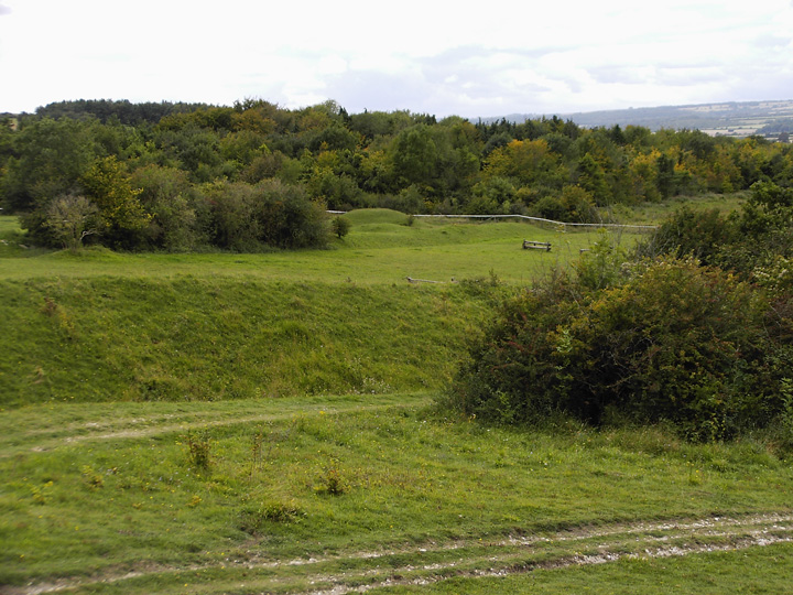
This is an interesting site as it's at a junction of Bokerley dyke and Grim's ditch. The barrows are on a show jumping ring and are in very nice condition, one is large and the other is a tiny round barrow, right next to the ditch.
At this point Grim's ditch runs into Dorset from Hampshire, going straight through Bokerley dyke.
Details of barrow on Pastscape - Monument No. 213422
A bowl barrow, one of a pair located side by side, just south of Bokerley Dyke and immediately adjacent to Grim's Ditch. Listed by RCHME as Pentridge 33 and by Grinsell as Pentridge 12, it was described by RCHME as a well-preserved mound 58 feet in diameter and 6 feet high, surrounded by a ditch 12 feet wide and 1.5 feet deep. Both of the barrows had been dug into in the past. It seems quite likley that they are to be identified with two barrows excavated by Hoare and Cunnington in the early 19th century. This identification is by no means certain, but this pair seem the most plausible candidates among the known barrows. If the identification is correct, this barrow, the larger of the pair, proved to contain "two skeletons, and several instruments of iron, viz. a lance-head, two knives, and an article of bone". These would appear to represent interments of Saxon date, probably dating from the late 5th to early 8th century. They may be the primary interments, but it is more likely that they represent secondary, intrusive interments in an earlier, Bronze Age, barrow. Grinsell lists the barrow excavated by Hoare and Cunnington as Pentridge 13b, declaring it unlocated. See Bowen (1990) for a discussion of the relationship between the linear earthworks and the barrows in this area.
Details of barrow on Pastscape - Monument No. 1313714
A bowl barrow, one of a pair located side by side, just south of Bokerley Dyke and immediately adjacent to Grim's Ditch. Listed by RCHME as Pentridge 34 and by Grinsell as Pentridge 13, it was described by RCHME as a mound 38 feet in diameter and 3.5 feet high, partially overlain on its north side by Grim's Ditch. It appears also to partly overlie its neighbouring barrow SU 01 NE 27, although the true relationship has been obscured by excavation. That excavation appears to have been undertaken in the early 19th century by Cunnington and Hoare, although the identification is not completely ceetain. However, this barrow seems the most plausible candidate for the one in which they found a large urn with its mouth placed upwards, and within it an interment of burned bones. The top of the urn seems to have been covered by two flat pieces of flint. A little further toward the south they discovered a large pit three feet deep, on the floor of which was a small Beaker-type pottery vessel. Grinsell lists the barrow excavated by Cunnington and Hoare as Pentridge 13c, declaring it unlocated. See SU 01 NE 27 for additional information and sources.
Details of Barrows on Pastscape - Monument No. 213346
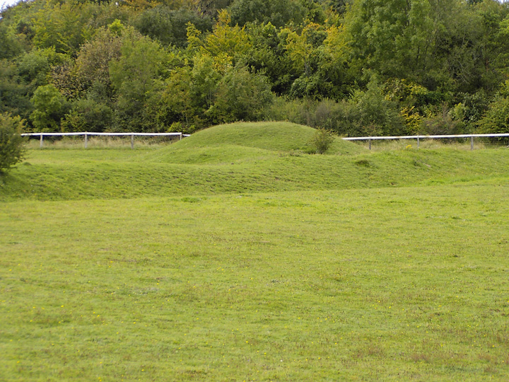
Bowl barrows; 'A' surrounded by visible ditch, hollow in centre. ('A' dia 20 paces, height 4 ft 'B' dia 20 paces, height 6 ft)
A. Diameter 19.0 m; height 1.5 m. Excavated at the top. Surrounding ditch approximately 2.0 m wide and 0.3 m deep.
B. Diameter 18.0 m; height 1.9 m. There appears to be a surrounding ditch 1.5 m wide and 0.5 m deep.
Both these bowl barrows have been excavated. The ditch measurements are approximate in each case since the ground was under snow at the time of investigation.
Tumuli (OE) SU 05541810 & 05561811.
Martin 26 and 27 are contiguous ditched bowl barrows contained in the north-west angle between Bokerley Dyke and linear [SU 01 NE 34] near the shoulder of Blagdon Hill. Both have been excavated, almost certainly by Sir Richard Colt Hoare in 1805 and seemingly again by W Chaffers in 1842. if this interpretation is correct, both contained cremations in large 'sepulchral urns', one. probably (26), being covered by an 'immense heap of flints' and the other said still to retain a covering of 'linen cloth'. Chaffers also found a 'sepulchral urn' in a chalk-cut cist, under each. These, as illustrated, are Deverel-Rimbury.

 Posted by formicaant
 Posted by Chance