|
|

|
|
South Ayrshire
|
|||||||||||||
|
|
|
Sites/Groups in this region:
|
5 posts
Ailsa Craig Natural Rock Feature |
14 posts
Arnsheen N Cairn(s) |
8 posts
Arnsheen S Cairn(s) |
|
6 posts
Bain's Hill Standing Stone / Menhir |
14 posts
Balchriston Stone Fort / Dun |
2 posts
Balmalloch Cairnfield Megalithic Cemetery (Destroyed) |
|
13 posts
Balmalloch Chambered Cairn Chambered Cairn |
14 posts
Bencallen Hill Chambered Tomb |
6 posts
Cairnfore Cairn(s) |
|
6 posts
Cairnwhapple Stone Natural Rock Feature |
6 posts
Cairn Hill (Dalquharran) Cairn(s) |
11 posts
Captain's Bridge (Drummochreen) SE Stone Fort / Dun |
|
11 posts
Captain's Bridge (Drummochreen) W Hillfort |
4 posts
Carlock Hill Cairn(s) |
3 posts
Coilsfield Cup and Ring Marks / Rock Art |
|
1 post
Craigie Hillfort |
1 post
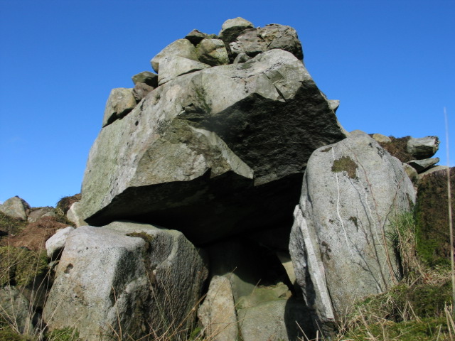
Craigs of Kyle Rocking Stone |
6 posts
Dinvin Hillfort |
|
11 posts
Drumduff Cairn(s) |
9 posts
East Threave Cairn(s) |
9 posts
Finnarts Hill Cairn Cairn(s) |
|
11 posts
Finnarts Hill Enclosure Causewayed Enclosure |
6 posts
Finnarts Hill Standing Stones Standing Stones |
7 posts
Gallop Hole Cairn(s) |
|
5 posts
Garleffin Standing Stones |
10 posts
Haggstone Moor Kerbed Cairn |
7 posts
Haggstone Moor Standing Stone / Menhir |
|
Hollowshean Camp
Hillfort
|
18 posts
Howmoor Stone Fort / Dun |
14 posts
Kildoon Fort Hillfort |
|
3 posts
King Coil's Grave Cairn(s) |
10 posts
Knockdolian Cairn(s) |
10 posts
Laggan Cairn (Barrhill) Cairn(s) |
|
5 posts
Lyonston Standing Stone / Menhir |
12 posts
Moss Knowes Natural Rock Feature |
6 posts
The Muckle Stane (Monkton) Natural Rock Feature |
|
6 posts
Penderry Hill Cairn(s) |
1 post
Spy Knowe Cairn(s) |
6 posts
Stonefield Park Road, Doonfoot Standing Stone / Menhir |
|
6 posts
Wallace's Stone Standing Stone / Menhir |
6 posts
White Cairn, Barrhill Cairn(s) |
5 posts
White Cairn, Laggish Cairn(s) |
|
10 posts
The Witching Stone Standing Stone / Menhir |
News |
|
|
Council celebrates staffing cuts by building a "Stonehenge" style monument on a roundabout Couldn't make it up. http://www.dailyrecord.co.uk/news/local-news/stonehenge-comes-ayr-town-centre-11719847 |
 Posted by Howburn Digger
20th December 2017ce Edited 20th December 2017ce |
Latest posts for South Ayrshire |
Showing 1-10 of 324 posts. Most recent first | Next 10 
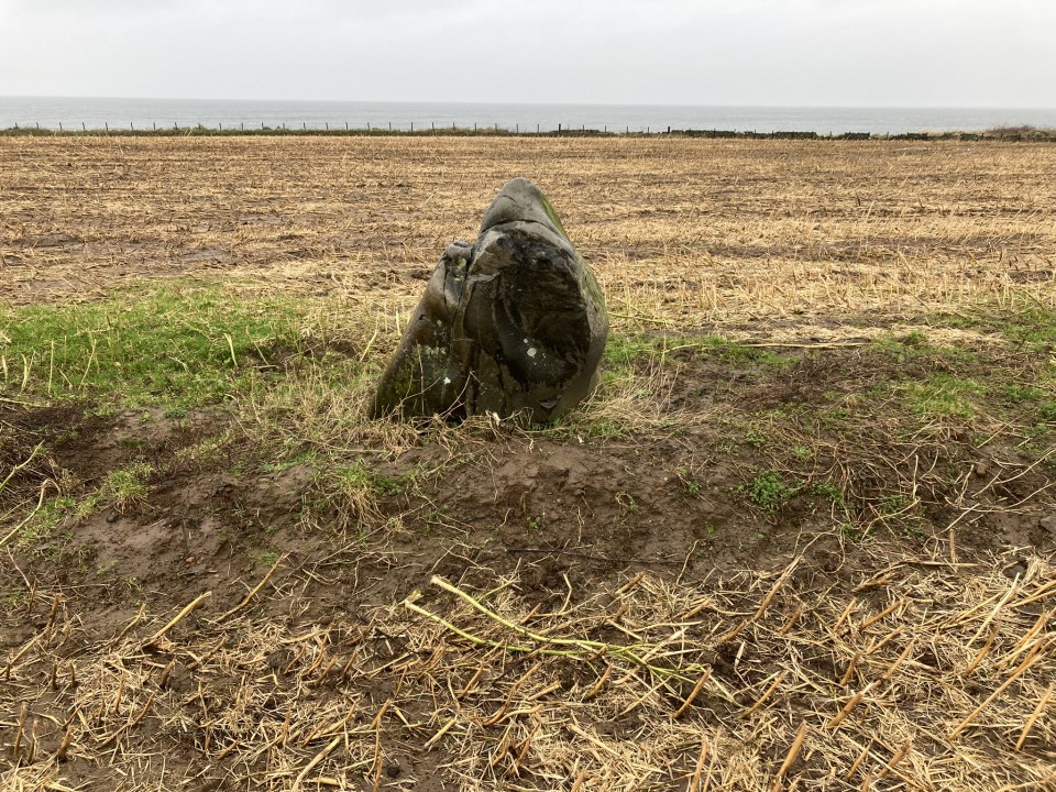
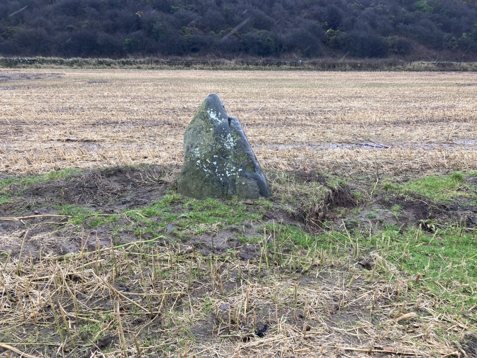
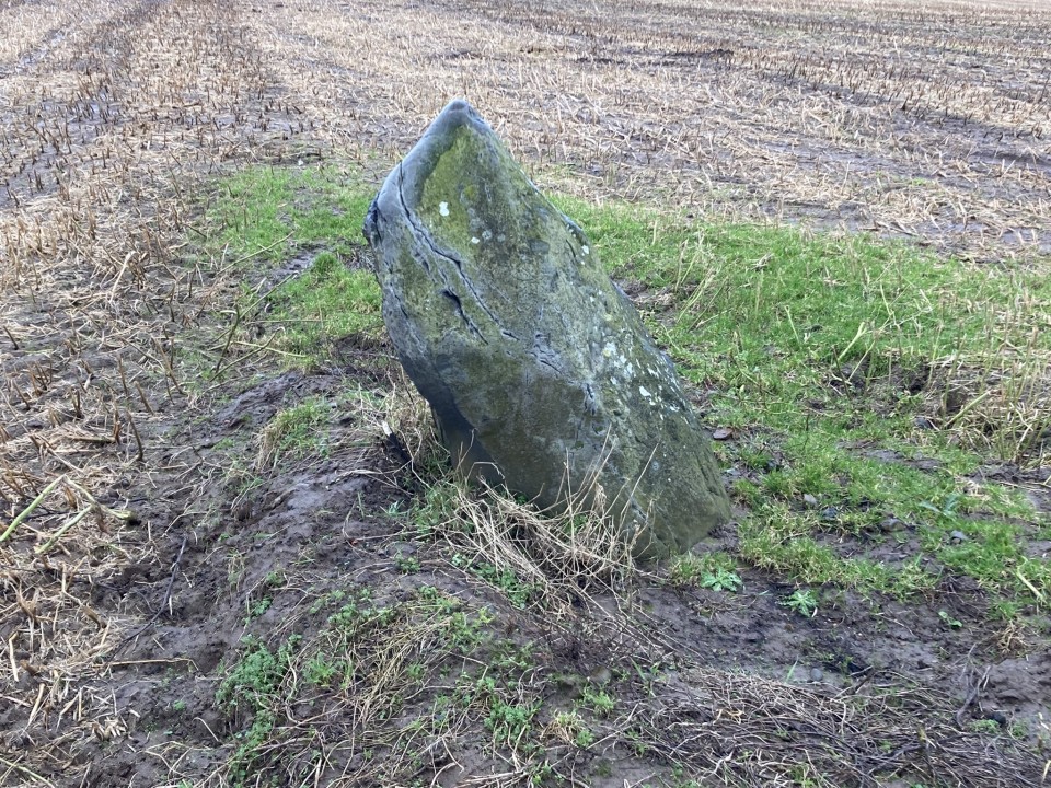
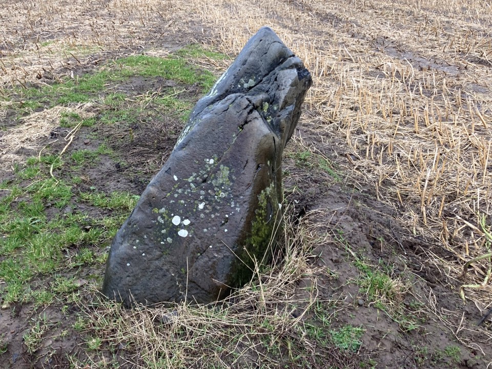
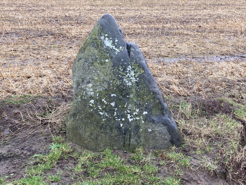
The Witching Stone (Standing Stone / Menhir) — Images (click to view fullsize) |
|
Posted by markj99 18th February 2024ce |
The Witching Stone (Standing Stone / Menhir) — Fieldnotes |
|
Visited 17.02.24 I've passed by The Witching Stone countless times, however, the field was usually in crop or I was on my way to somewhere. Yesterday, while travelling home from a Bill Bailey concert, I noticed that the field enclosing The Witching Stone was being drained so it seemed like a good opportunity to finally visit the standing stone. My first difficulty was finding a place to park on the busy A77. After some trial and error I parked down the track to the cottages S of the Alginate factory. The lane is a high tide detour off the Ayrshire Coastal Path. The track leads onto the beach. After following the coast S for c. 0.5 mile i headed to a gate in the NW corner of the field. The Witching Stone was c. 150 yards SE from the gateway across a sodden field (I had wellies on obviously). The Witching Stone is natural pointed boulder leaning c. 30 degrees ESE. It is set upright with broad sides on a ESE-WNW axis. The stone measures c. 4x3x1 feet. The overall height is reduced to 3.5 feet by the lean. It is located at NS 19924 01730 (transcribed from OS Aerial Mapping). There is no obvious reason why this rather ordinary stone has been set upright and preserved in the field. It is not listed on Canmore and a Google search for Standing Stone The Curragh Girvan produced no result. |
Posted by markj99 18th February 2024ce |
King Coil's Grave (Cairn(s)) — Folklore |
|
Speaking of Coylton, on the Water Of Coyle, the Statistical Account Of Scotland (1798) says; 'There is a tradition, though it is believed, very ill-founded', that the village derives its name from a King Coilus who was killed in battle in the neighbourhood and buried in the church here. Fergus Loch, to the west of the church, 'is supposed by some to take its name from King Fergus, who defeated Coel King Of The Britons in the adjacent field'. According to others, however, the battle was fought in the parish of Tarbolton, and they pointed to the slabs of stone covering a burial mound known as King Coil's Tomb in the grounds of Coilsfield House. The tomb is probably the cairn marked near Coilsfield Mains on modern maps. The site was investigated in May 1837 by the minister of the parish, the Reverend David Ritchie, whose report went into the New Statistical Account 1845. The excavations unearthed a circular flagstone covering another, smaller stone which itself covered the mouth of an urn filled with white coloured burned bones. Other urns were found nearby, and though no coins, armour or other implements were discovered, Ritchie notes: An old man remembers that his father, then a tenant on the Coilsfield estate, turned up pieces of ancient armour and fragments of bone when ploughing the 'Dead-Men's-Holm.' Reverend David Ritchie 1845 |
17th February 2024ce |
Captain's Bridge (Drummochreen) W (Hillfort) — Fieldnotes |
| Directions to Captain's Bridge (Drummochreen) W: Take the B741 Dailly road off the A77, N of Girvan. After c. 5 miles stay straight on for Maybole at the Dailly junction. Continue towards Maybole for c. 1.7 miles to a farm junction on the left at NS 28593 03605. Park up and walk c. 120 yards W along the dirt track to a green track on the left. Walk 5 yards along the green track. Look left to see the outer bank and ditch of the fort. Climb over the bank to enter the enclosure of Captain's Bridge (Drummochreen) W fort. |
Posted by markj99 28th November 2023ce |
Moss Knowes (Natural Rock Feature) — Fieldnotes |
|
Directions to Moss Knowes from South: Take the A714 Girvan at the N end of Victoria Street in Newton Stewart. Follow the road for c. 8.4 miles to Bargrennan. Take the right turn to Glentrool Village. Follow the road for c. 9.3 miles to a Y-junction. Bear right for c. 4.7 miles to reach Stinchar Bridge. There is a right turn signed for Forest Drive. Take this narrow road for c. 1.2 miles to a dead-end. Park up and follow the Carrick Forest Drive for c. 1.7 miles to reach a right turn just before Loch Riecawr. Take the right turn heading S for c. 1.1 miles to reach Moss Knowes Rocking Stone. It is c. 25 yards SE of the forest track in an open area of felled forest. Directions to Moss Knowes from North: Take the B7045 Straiton left turn off the A77 just S of Minishant. Stay on the B7045 for c. 3.9 miles to a Y-junction on the edge of Kirkmichael. Bear right along the B7045 for c. 4 miles to Straiton. Follow the Newton Stewart road straight through Straiton for c. 7.3 miles to reach Stinchar Bridge. There is a left turn signed for Forest Drive. Take this narrow road for c. 1.2 miles to a dead-end. Park up and follow the Carrick Forest Drive for c. 1.7 miles to reach a right turn just before Loch Riecawr. Take the right turn heading S for c. 1.1 miles to reach Moss Knowes Rocking Stone. It is c. 25 yards SE of the forest track in an open area of felled forest. My walking route is viewable on Moss Knowes Rocking Stone. |
Posted by markj99 19th November 2023ce |
Showing 1-10 of 324 posts. Most recent first | Next 10