|
|

|
|
Capler CampHillfort
|
||||||||||||||||||||||||
|
|
|
Images (click to view fullsize) |
|


|
Fieldnotes |
|
|
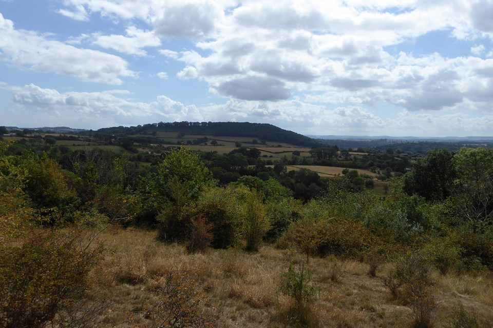
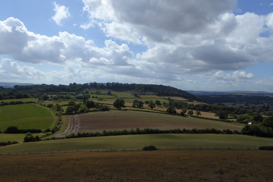
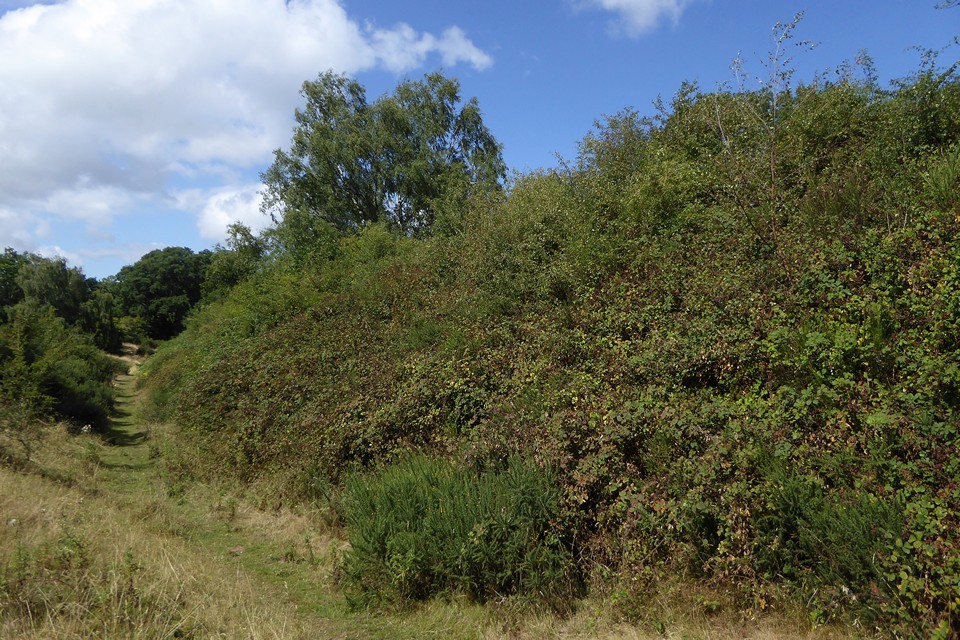
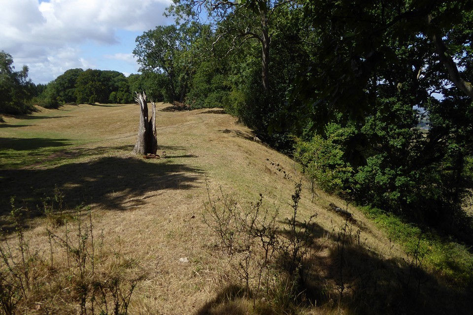
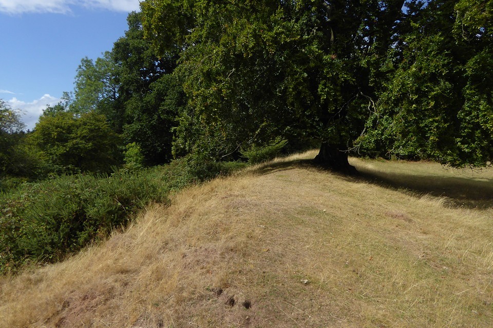
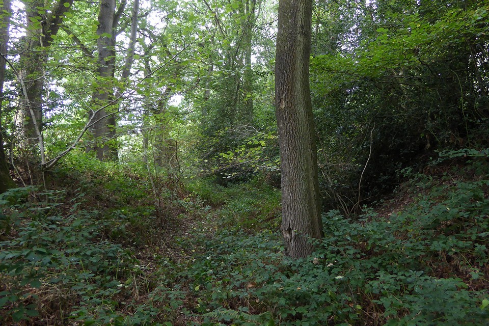
Visited 12 August 2017. After last weekend's unplanned spontaneous trip to British Camp in the Malverns, this weekend I have a plan. And it's a cunning plan, so cunning you could put a tail on it and call it a fox, etc. Anyway, I'm off to Fownhope, a little village on the banks of the River Wye towards the south of Herefordshire. As well as two pubs (one called the Green Man), a shop and fine church with slightly twisty spire and a Norman tympanum carved with a toothy winged lion, Fownhope sits between two wooded Herefordshire hillforts. I have three hours to visit them both. That's the plan. Things start promisingly, the sun has come out and the bus from Hereford drops me off on time. I've decided to visit Capler Camp first, on the basis that it looks less likely to be an overgrown slog and also it's further away than Cherry Hill, which is right next to the village, so will help gauge the time I have better. A fairly straight minor road leads from Fownhope church towards Capler. I've anticipated a slow climb followed by a steep bit at the end, but that's because I haven't read the map properly and don't realise that the whole way is a succession of up and down hill bits, guaranteed to tire out of practice legs before I even arrive at the proper hill. The first of these ridges does at least give a nice view of both forts from about halfway between them. A buzzard flies over the tractor throwing up dust in the nearby fields, sheep are cajoled and corralled at Rise Farm, and I realise that there is a good view of Aconbury, another of Hereford's fine hillforts. Passing Capler Cottages marks the start of the steep section of the road, but a slightly overgrown track beckons invitingly off to the left, promising a less direct and more zig-zag route up to the fort. It proves a good choice, quite dry despite the ridiculously wet summer, and far less steep than the road would have been. It emerges near the top of the footpath to the south of the fort. From here I head to the ramparts. The fort is in two distinct halves, the western side covered in trees, the eastern side an open field. I head west, into the trees. It's not a good time of year to visit wooded hillforts, brambles make the earthworks difficult to access and the thick canopy makes photography frustrating. Nevertheless, getting round this fort is easy enough as a wide swathe has been cleared inside the perimeter of the inner rampart, and a broad track follows what would have been a ditch between the inner and outer defences. The defences are strongest on the south, two lines of earthworks making up for the relatively shallow gradient compared to the west end and north side. It's very pleasant under the trees and on reaching the north side I drop down from the inner rampart to the track below. On the north side the natural steepness does all the work, and the track is a good three metres or more below the inner rampart. Some of the trees that mark the outer "bank" here are towering, one is a venerable beech that wouldn't be out of place on the chalk Downs or limestone scarps to the southeast. The woods are an attractive deciduous mix, not the dense conifers of recent forestry plantations, but an older woodland that feels right on this hilltop. At length I come round towards the eastern end. Climbing the inner bank brings me out into the open half of the fort. I'm somewhat surprised to find a tall post, carved to the effect that this is an Iron Age hillfort. It turns out that this is the end of a succession of similar posts marking a permissive path up from the picnic area on the road to the south. The interior is lovely, the inside of the southern rampart is rich with harebells. From here the view stretches south and east. I'm not in the slightest surprised to see the ever-present shape of May Hill, while the vista to the south is filled with the dark mass of the Forest of Dean, over the border in Gloucestershire. To the southwest the edge of the Black Mountains is visible. This is a great spot, and I end up sitting here for a while in the summer sunshine. Finally leaving through the eastern entrance, past a lovely old stone barn and a neat cottage, I follow the Wye Valley Walk footpath along the outer rampart. It's a good hillfort this, not perhaps in the front rank of Herefordshire examples like Wapley Hill and British Camp, but a very decent site nonetheless. Reluctant to leave, I take a final turn around the wooded half of the interior, before heading south back to the road. A little picnic area gives glimpses of the Wye sparkling in the sunshine below, living up to its picturesque billing. I follow the road down, noticing the steepness and also how many cars seem to be driving up and down this narrow lane, from nowhere to somewhere or back again. The extended stay has wiped out the time I have left, and Cherry Hill will have to wait after all. A Spring visit would be better anyway I reckon. The best thing about a cunning plan is how easily it can be abandoned or reshaped, and this one will easily bear a bit of reshaping. |
 Posted by thesweetcheat
14th August 2017ce |
|
Visited 29.8.11 Directions: Just to the south east of the village of Fownhope, not far from Cherry Hill Camp Hillfort. Heading down the B4224 you will see a sign for Caplor Farm farmshop. Take this turning and there is plenty of room to park in the car park. (unfortunately the shop was closed when we arrived which was a shame as myself and Karen quite fancied a cuppa!) From here the well signed public footpath leads you straight to the Hillfort. Once through a field of sheep it is a case of trudging up the steep muddy path leading through the trees up to the top. This is greatly helped by the 66 steps kindly provided. Once at the top of the steps you will see an old barn. Turn right and you are there! The Hillfort itself is not very big and has a sort of large 'hole' in it on the northern side – looks like a bit of quarrying at some point? There is no need for defences on the northern side due to the very steep incline. A fence runs all along this side of the site. The bank surrounding the rest of the site is clear to see and it bears the trace of lots of feet walking along the top of the ramparts – a nice enough little walk. This is definitely a place to visit at Christmas time as there was plenty of holly with berries in evidence as well as a large clump of mistletoe. When arriving back at the car I tried to use the mistletoe's 'magic' on Karen who quickly informed me that the 'magic' only worked at Christmas time!! |
Posted by CARL 31st August 2011ce |
Folklore |
|
The visitors [to Woldbury Camp] were soon engaged in examining its embankments, considering the water supply, and taking the height of the summit, where stood that now familiar object, an Ordnance Survey pole. The papers were to be read beneath the yew trees on the large south-western embankment, where "the British Chieftain was buried," said a resident on the spot.From 'Transactions of the Woolhope Naturalists' Field Club (1883-85). In a fantastically patronising touch, the report finishes by listing all the gentlemen who attended, "with a sprinking of natives, who came to listen to the papers, and pick up a few crumbs of science, and who, it is believed, listened with much gratification to the many-syllabled words introduced on the occasion." I fear people with that kind of attitude are alive and well in 2011 and employed in the government :) And not folklore, but certainly a weird occurrence, that in April 1793, there was a massive landslide (quoted from p48): .. the ground sank fifty perpendicular feet, and then moved forward. It was witnessed by a labourer, who, when working near a hedge, found the ground moving, and at the same moment heard a loud noise resembling a distant hailstorm. Running from his work towards the river, across a narrow meadow, he observed with alarm the sloping hill, with trees on it, moving gradually towards him, and this progressive movement is said to have continued from Thursday to the next morning. It was a movement downwards and in its progress S.W. It has left immense caverns in the earth, and moved stones there of the magnitude of five or six tons. A number of trees were thrown down, some moved standing and are now remaining so. A large old yew tree was moved nearly sixty feet, and is now standing firm and uninjured. The people assert that six acres of ground were moved. Yet another snippet from the same journal has it that a quarry on Capler Hill is the traditional source of the stone for Hereford cathedral. |
 Posted by Rhiannon
23rd March 2011ce Edited 23rd March 2011ce |
To add to Paulus's post about the mound, Mr Watkins obviously thought this part of a ley:Motoring into Linton, Herefordshire, I found the road sighted through that church to May Hill in the distance. On the map this alignment lay on a stretch of ancient road called The Line, with a house on it called The Line House. Sighted backward, the alignment goes through the edge of Lynders Wood, on to a sighting mound standing at the end of Capler Camp, from which I had noted that May Hill was a prominent object. Not far away was a place called Lea Line. [..]From Notes and Queries, p62, July 28, 1928. |
Posted by Rhiannon 26th August 2007ce |
Miscellaneous |
|
Nearly opposite Holm-Lacey, on the east bank of the Wye, is the pleasant village of Fownhope, about half a mile to the north of which is an eminence crowned by an ancient Camp; and about twice that distance to the north*, is a second Camp, occupying the summit of another eminence, called Capler Hill: the latter Camp is double trenched, and called Woldbury; the former has no distinct appellation**. The Capler Hill is finely wooded; and from its summit the prospects are extensive and rich: the contiguous channel of the Wye forms a striking feature.p507 of v6 of 'The Beauties of England and Wales' by John Britton + others (1805). *actually it's to the south. ** this is Cherry Hill Camp. 'Picturesque Views on the River Wye' by Samuel Ireland (1797) calls Capler Hill 'Wobury' (p65). |
Posted by Rhiannon 26th August 2007ce Edited 26th August 2007ce |