|
|

|
|
Broomend of CrichieCircle henge
|
|
|
|
Sites in this group:
|
6 posts
Broomend Standing Stone / Menhir |
5 posts
Broomend 2 Standing Stone / Menhir |
7 posts
Broomend Cist(s) Cist |
Images (click to view fullsize) |
|


|
Fieldnotes |
|
|
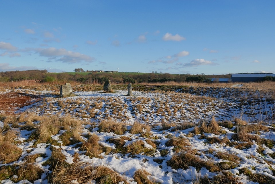
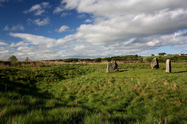
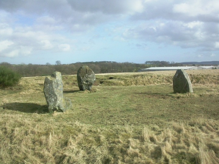
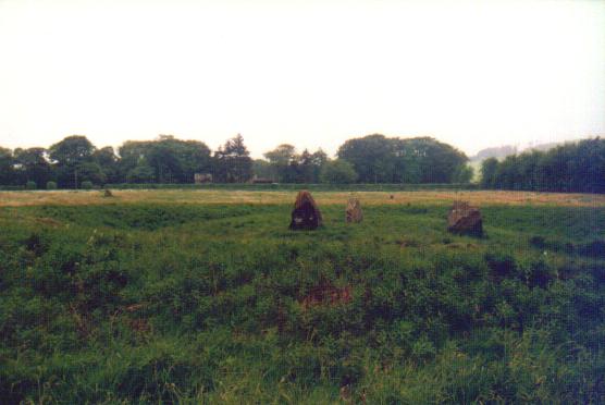
Visited 27.7.14 Directions: At the southern end of Port Elphinstone – behind the BP petrol station Today was the first day we had rain. Considering we were now into the second week of our holiday we could have few complaints. The area in which the henge stands is overgrown and has the appearance of waste ground – although I am sure it isn’t! Access to the field is via a metal gate. The henge is easy to spot with the bank being between 1m and 2m high from the bottom of the ditch. The standing stones are between 1.5m and 1.8m high. The Pictish symbol stone has nice markings on it. At least the weather made them easy to see. It is a pity more is not made of this site. A good hair cut and an information board would go a long way. It doesn’t look like many people come here which is a shame. Well worth a visit if you happen to be in the area. |
Posted by CARL 18th August 2014ce |
|
A site of this magnitude is deserving of more than the hour I have available after an afternoon at the wondrous Rothiemay. Having said that, however, an hour is purposely all the time I've allotted, since, despite the exquisite lighting conditions I cannot deny that I find myself somewhat 'on edge', uneasy even, at the way the Port Elphinstone locals treat their ancient heritage. Rubbish lies all around, violating henge bank and ditch to such a degree that I soon realise a skip would be needed to make any impact. Yeah, the vibe is all wrong, much like the henge at The Bull Ring before TMA's Blingo recently did something about that fine site. So perhaps an hour is currently about right.... Despite such negativity, come here you must. For although one of the trio of uprights within the fine, upstanding henge earthworks, is a Pictish 'newcomer' (ha!), the aesthetic effect is first class, particularly when viewed under a dramatic blue sky featuring the optimum cloud cover. The henge is located to the approx south-west of the confluence of the Rivers Urie and Don, the significance of this perhaps the defining criterion way back then. Nowadays a petrol station, industrial area and housing estates form an inappropriate backdrop, masking the influence of Bennachie. [Drewbhoy's suggestion that Port Elphinstone might have been the 'harbour' mentioned by Tacitus in relation to Mons Graupius is intriguing]. Of the avenue and RSC which apparently once formed part of the ritual complex here, all I can see is a single standing stone to the south.... so much has been irretrievably lost. However an awful lot still remains.... much more than I anticipated, to be fair. As people walk their dogs, I instead take myself for a walk... much to my surprise beginning to access a vibe I thought did not - could not - exist. Things need to change here... a local stalwart needed to break the mould and rise above the overwhelming feeling of 'who gives a monkey's?' Someone to reawaken local communual pride in this megalithic treasure which is still just about hanging on in there. Then perhaps there will still be hope for Broomend of Crichie? I truly hope so. Consider this... much effort has been undertaken to build a - by all accounts - pointless cairn overlooking a nearby Kemnay housing estate. Why? To paraphrase John Lydon... why do we persist in believing illusions, when so much is for real? Could not some sponsorship be forthcoming from local business to safeguard the future of this wonderful little henge. Before it's too late? Note: If you're reading this and want to accept the challenge... but don't know where to start...why not contact Blingo - via the Forum - and see what can be done? |
 Posted by GLADMAN
25th June 2011ce Edited 26th June 2011ce |
|
What, on first appearance, seems to be a grim and desolate spot, behind the petrol station and surrounded by industrial units, becomes a revelation upon closer inspection. There was still enough of this site left to make it utterly charming, if in need of a little TLC. We wandered around for much longer than we had anticipated and (as usual) talked a lot of drivel, wondering and the whys and wherefores of it all. Definitely worth the diversion and a site that sticks in my memory. This post appears as part of the weblog entry Aberdeenshire Antics
|
 Posted by Vicster
17th January 2010ce |
|
This can be seen from the petrol station at Port Elphinstone. Two stones are original, the third, furthest right, has Pictish markings and was moved there during the construction of the railway. A long time ago there was an avenue of stones leading to a RSC. Two of these stones remain, one beside the henge, the other in the garden at the paper mill end towards Kintore. Seen every week, as like others I often sit and have some lunch! |
17th June 2009ce Edited 17th June 2009ce |
|
Anywhere else but Aberdeenshire, I would have gone for a poke around the henge and the stones in this undoubtedly important site. But after a busy and long day looking at nearby stuff like Sunhoney and East Aquhorthies I couldn't even be arsed to get out of the car. So we parked behind the garage and sat and looked at the monument as we munched our chips for tea. This is clearly worth more than the miserable effort I took. This post appears as part of the weblog entry Hot stuff in Aberdeenshire: stone-baked
|
 Posted by Jane
30th July 2006ce |
|
Earlier on this year part of the henge had keyhole excavation work done by Richard Bradley and team. We are waiting for the results of the total findings... but the day I was there bone fragments had been found in the inner circle, a possible wooden post hole was being pursued and the henge looked like it was actually 'U' shaped with straight vertical walls and much deeper than what we see today. Fantastic to see what lies under the grass and how big this site must of been with its stone avenue of 72 stones and possible recumbent stone circle at the end of the avenue past the henge which possibly housed 6 stones. Surely the most important site in the NE and usually the most over looked. I love this site, alone in its field surrounded by the paper mill, housing estates and petrol station... under the moon all this is forgotten... ancient connections still being made! |
28th December 2005ce Edited 28th December 2005ce |
|
05/01/2004 Update to my local plan objection regarding development plans for the Broomend of Crichie site: The council have "partially" accepted my objection, and have ammended the structure plan to show the full scheduled area including the henge as protected from development in this plan's life. It is not clear to me for how long this will protect the monuments. I have decided to present my arguments to the report enquiry so that the objection is noted more clearly on the public record, and I obtain clariy as which parts of the objection the council do not currently accept. The hearing has been delayed until April 2004 on a public communications fasilure technicality. I have heard annecdotally from a 70 year inhabitant of the village, that this is not the first time that developments have been attempted on this site. I have no documentary proof of this assertion however, and the local paper office could not help me with an archives enquiry when I visited their office recently. Jon Metcalf |
Posted by metcaljj 5th January 2004ce |
|
Lengthy posting follows, for which all due apologies, however I bring good news. I wasn't happy about just fearing for the future of this site, so have done something positive about it. The two plots of land (P1 and P2) which make up this site are listed in the Aberdeenshire Local Plan for "access" and "environmental" developments. This plan was posted on the council website for consultation in the 6 weeks ending 11/10/2002. http://www.aberdeenshire.gov.uk/localplan/maps/Garioch%20main/Inverurie%20and%20Port%20Elphinstone.pdf The nature of the developments are not detailed in the plan. I visited the local council planning office in Inverurie to try to find out more, but the people working there didn't have any detail. They did suggest that landscaping and a children's play area may be involved however. The prospect of landscaping raised grave concerns for me since since most of the henge monuments in Scotland have been obliterated as surface features by ploughing. The site contains several Scheduled Ancient Monuments, which are therefore subject to National Planning Guidelines (NPPG5 para 17), and the protection afforded by the 1979 AMs act. Most of the site has been owned by Aberdeenshire council since 1967, during which it has been benignly neglected. In the two hundred years or so before this, the site has a history of abuse of nationally important archeology for building stone and railway aggregate. I questioned the development using the formal objections procedure. I copied the custodian of the National Monuments Record of Scotland, the Aberdeenshire county Archeologists Office, and Historic Scotland for information purposes. The NMRS people said thanks for the warning, however legally they could not express an opinion on the plan. The council planners said they had contacted the county archeologist who had checked my points, agreed them all and could not understand how they had missed the monuments when OK-ing the draft plan. They acknowleged that for any development to go ahead on the site, that Historic Scotland would have to give the go ahead (the protection afforded by the 1979 act with a presumption of no development). Ominously HS were consulted on the plan and did not raise any concerns about this site, though hopefuly that was just an oversight as it is a several hundred page document. I copied HS on my email to the council, but have yet to receive a response from them. Here are my questions and contextual material sent to the council. They phoned to say they had checked my points out, agreed them all, and couldn't understand why development had been proposed. The guy who made the proposal was on holiday, but will be back and will revert in w/c 28/10/2002. I will try to report further to this site. I made the point verbally to the council that not all development was necessarily bad. If the site were grassed undamaged, and some interpretive boards put nearby, that could be an improvement over the rusty fence and scrubland currently in place for example. "Questions: 1) In more detail, what specific developments are planned for the P1 and P2 sites, and when. 2) What protection will be afforded to the following monuments, and how will they fit into the proposals. RCAHMS NMRS NJ71NE 6 (Scheduled monument - one of just twelve 1:50,000 mapped henges in Scotland) Stone Circle (two original stones remain, plus symbol stone RCAHMS NMRS NJ71NE 8 moved during railway construction), Class II Henge diameter 33m approx, and 2 Cists 100m South of henge. Stone avenue sockets leading to henge from south (all 72 stones bar the three remaining today destroyed in 19th century). Most recent excavation of stone sockets 2001. RCAHMS NMRS NJ71NE 7 Site of three concentric rows of erect stones with a small cairn in the middle, and a flat altar-stone, with a cavity in the upper part, raised on a rough cairn (recorded 1757). Now the site of a derelict sandpit. RCAHMS NMRS NJ71NE 8 (Scheduled monument - one of 30 scheduled Pictish Symbol stones in Aberdeenshire) Class I symbol stone : South face shows an elephant above a crescent and V-rod. Having visited most of the known pictish symbol stones of Scotland, I can confirm that this is an exceptionally well preserved example. Moved to current location during construction of the railway as the rock under its original site was quarried for ballast. Square Barrow structure At the original location of the above symbol stone (NJ 7798 1970) on CUCAP air photograph BVD 083. Context In the whole of Scotland, just 75 henges or suspected henges are recorded in the National Monuments record. Of the ones not dismissed as miscataloged natural features, just 42 are scheduled, just three of which are in Aberdeenshire. The majority of both scheduled, and unscheduled henges in Scotland have been severely damaged over the past 100 years, as successive site reports in the NMRS demonstrate. Most have now been completely obliterated as surface features by ploughing, and can now only be detected by crop variations from aerial photographs. Although it beggars belief, a further group have had modern buildings or forestry put on top, or metalled roads put through them. Just 12 remain as sufficiently distinctive features to be mapped by the OS as henges at 1:50,000 scale, 11 of which are scheduled, one of which is in the P2 area of Port Elphinstone. A monument of this rarity, and comparatively excellent preservation must be protected. In the whole of Scotland, there are fewer than 250 pictish symbol stones, of which a fifth are in Aberdeenshire. Just 30 of the Aberdeenshire stones are scheduled, including the well preserved example on the P2 site. Given that the symbols on some of the Aberdeenshire scheduled stones are completely illegible (eg NJ53NW 1 at Huntly), have been smashed up comparatively recently (eg NJ72SE 23 at Brandsbutt), or defaced by later carvings (eg NJ71NW 12 in Monymusk church with a hideous OS benchmark), then protection of the few known clear and uncompromised examples is very important. " What I hadn't realised before sending the above, is that henges are unique to the British Isles (according to the Time Team website). From this Head Heritage website I can see there are a bunch beyond Scotland, but wonder if anyone knows how many, or how many are scheduled, or even if there is an online way of determining this? My main research source for the above objection was the brilliant RCAHMS website listing the archeological records of all known Scottish sites, and featuring a brilliant GIS search engine to see exactly what has been recorded in any Scottish location on any scale of mapping. Free accounts at http://www.rcahms.gov.uk/canmore/login.show . Go use this. You'll find out a bunch (11 pages from 1856 surveys onward for this site alone) and UK tax payers pay for it! Jon Metcalf Declaration of Interest: I'm a keen armchair student of OS maps and visitor of ancient monuments, particularly pictish remains. I've lived about 3km from Broomend of Crichie for a decade, so care about this site in particular. I work for BP, and both researched and made the above objection on their time between day job tasks, with the organisation's support. It is easy to be cynical about any large organisation's line on caring about the environment, however in my 15 years at BP, I have found that it "walks the talk", for example offshore putting emissions limits above production, despite investor pressures. The garage cited in earlier postings has had no impact on the monuments at all. Hopefully the objection above, made on BP's time, will have a lasting positive effect. |
Posted by metcaljj 15th October 2002ce |
|
Well this was a change after a solid morning of RSC's, and very welcome too. You don't get too many Henges in this part of the world, and this is a mighty one. Although the stones are not in their original positions (and one isn't original at all!), the triangle they form is certainly evocative, especialy in such a well defined, fairly deep henge. I drove up not expecting too much, and drove away feeling blown away. Another great site in this part of Scotland, but as Merrick says, you have to fear for its future. |
 Posted by Chris
5th September 2002ce |
|
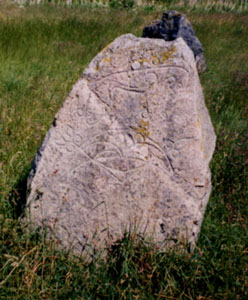
(visited 29 June 00) Beside a dual carriageway, behind a BP petrol station there's a field containing a 30 metre circular bank and ditch, causewayed to the north and south. On an island in the middle are three stones. It's a puzzling site. The stones are clearly not edge-on like circle stones; perhaps they have been moved, perhaps they are a 'cove'. Difficult to tell how many (if any) stones are missing. One stone has a beautiful Pictish bird-thing carved into it. I'm told that it was once a circle, and that the pictish stone was moved from its original site in the 19th century and put here for want of anywhere better. About 100 metres due south in the same field is a single stone. Another 100 metres beyond (over a road and through a hedge into someone's garden) is another stone. Beyond that (as far as I can tell from the map) by another 200 metres is another, but it's in the grounds of Broomend paper mill, a big fuckoff factory. I'm told that these stones were once part of a long alignment running from the river up to the henge and then beyond, in a manner similar to Shap in the English Lake District (Modern Antiquarian, page 250). Whether the north-south alignment of the causeway and the missing stones is due to the seasons and compass or the north-south alignment of the river is a matter for conjecture. The mill, road, petrol station, flats and houses around this field are all clearly very recent. The fact that the three outliers are on three separate properties doesn't bode well for their safe upkeep. The way it's been so rapidly surrounded with such overpoweringly intense development, I'll be surprised if the field itself is still a field in twenty years time. |
Posted by Merrick 7th August 2000ce |
Links |
|
University of ReadingA report with some conclusions on the excavations at this complex site in 2005-7. |
 Posted by Rhiannon
13th July 2010ce |
Extreme Stonefeelers' World of Hard Rock & Standing StonesPics of the stones and henge at Broomend of Crichie. |
 Posted by new abbey
11th April 2010ce Edited 11th April 2010ce |
ARCHwayAn long PSAS article from the 1920s about Broomend of Crichie - it includes a rather nice map of adjacent stones. |
Posted by Rhiannon 10th November 2006ce Edited 7th February 2010ce |
Latest posts for Broomend of Crichie |
Showing 1-10 of 18 posts. Most recent first | Next 10 
Broomend 2 (Standing Stone / Menhir) — Fieldnotes |
|
This standing stone is on the business centre side of the track, moving closer to the paper mill, standing beside a small farming building. Probably part of the stone row it stands at over 1 meter high and fits with Chris's and my own theories about the henge. So another part of the jigsaw was found thanks to an auld granny giving me row for not using my eyes properly. Visited 7/02/2013. |
9th February 2013ce |
Broomend Cist(s) — Fieldnotes |
|
From the henge on the outskirts follow the road round until it ends at the barriers, to the left a business centre, straight on is the now sadly defunct paper mills. At the barrier head into the wood to the south and walk 500 yards or so. It is pure fluke I found out about these as the grandmother of one of my pupils asked me if I'd looked properly in the woods at Broomend. Obviously I hadn't and was glad for the tip. Several cists have been pulled together to sit beside a capstone, 2 meters by 1 meter possibly made into a seat to overlook the man made lake. Looking at old maps the area was covered in cists and long before standing stones stood in a row coming from the henge. Sadly most of these have gone but my tipster told me there was one more nearby. She was right. Visited 7/02/2013. |
9th February 2013ce |
Broomend Cist(s) — Images (click to view fullsize) |
     
|
8th February 2013ce |
Broomend 2 (Standing Stone / Menhir) — Images |
 
|
8th February 2013ce |
Showing 1-10 of 18 posts. Most recent first | Next 10