|
|

|
Ashdown Park SarsensNatural Rock Feature
|


|
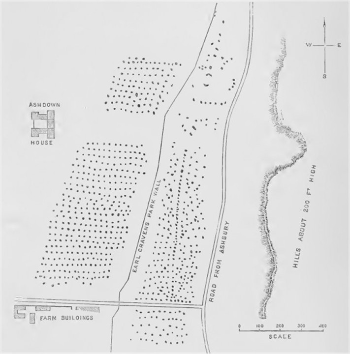
 Image Credit: A.L. Lewis
Posted by Chance 21st July 2010ce Edited 21st July 2010ce |
NB: Unless otherwise stated, this image is protected under the copyright of the original poster and may not be re-used without permission. |
Comments (6) |
|
|
Hi Chance, That plan makes the site reminiscent of Carnac, regarding the apparent alignment of the stones. Also, the lines of the Earl Craven's Park Wall, and the Road From Ashbury are similar to the shape of a lot of the cursus monuments. Not saying it is a cursus or owt, but sometimes roads and walls follow older lines. Also, there are examples of cursus that have stones and long mounds inside. Just a thought, TE. |
 Posted by The Eternal
25th August 2010ce |
|
Old drawings are always fascinating but I think this one is misleading in its neatness; Ashdown is a sarsen drift valley much like the Fyfield sarsen drift. |
 Posted by tjj
25th August 2010ce |
| Artistic license, eh? Thought it looked too good to be true. |
Posted by The Eternal 25th August 2010ce |
|
Hi TE I would not be swayed too much by TJJ's "neatness" remark. The Ashdown sarsen drift was originally a natural feature, but has been altered since the Neolithic period when Lambourn and Wayland's Smithy Long Barrows where first constructed from its stones. The road almost certainly dates from this period when the stones were first moved up to the Ridgeway and South to Lambourn. The survey made by A.L. Lewis in 1853 is from the exact time period that the Fyfield sarsens were first being commercially broken up by industrial means. This was about ten years after the Great Western Railway had been completed and stone was being carted off to Swindon for buildings and roads. I'm not certain about the timeline but parts of Lord Craven's estate were broken up around this time, although Ashdown house stayed in the family and additional out buildings were added, only to be demolished by the NT when they took over the estate in 1956. The field nearest the road is known as sarsen field and although the number of stones is reduced from the sketch, the Google earth image shows how accurate Lewis's survey was. The area between the Park Pale and the house seems to be far more reduced in stones but the trees tend to hide the full detail. Chance |
Posted by Chance 26th August 2010ce |
|
Chance, your comment is addressed to TE but as it referrs to something I wrote I hope you don't mind me coming back on it. Firstly, no disparagement was intended by my use of the word 'neatness', I was simply drawing on my observation that Ashdown is a sarsen drift rather than a Carnac like site. I re-read your first paragraph a couple of times and understand you are saying the road may have originally been neolithic, similar to the Ridgeway, and used to transport stones to nearby barrows. I will take a walk over that way in the not too distant future and have another look in the light of what you have said. I hope that TE will come back and read your comment later ... as he was on the right track after all. tjj |
Posted by tjj 26th August 2010ce |
|
Chance, Thanks for the info. It looks an interesting place. As you say, I'll have to check Google Earth - forgot about that. June, Ta for your two-penneth. Regards to all, TE. |
Posted by The Eternal 26th August 2010ce |
| You must be logged in to add a comment | |