|
|

|
wideford’s TMA Blog |
|
MAY 17th 2010 STENNESS & STONE OF ODIN
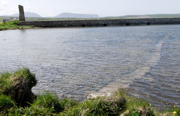
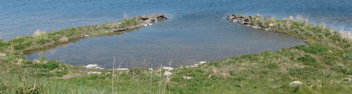
| A propos holed stones in Stenness the earliest reports are of two sentinel stones along the shore either side of the southern end of the Bridge of Brodgar, of a height on a par with the Stones of Stenness, with one of them holed. The earliest labelling of these is of a "stone of power" (Watch Stone) and a "stone of sacrifice" (the Odin Stone it would seem). Pococke shows the latter as a large diamond-shaped boulder but that is because part of the base is hidden - John Clevely in 1772 depicts the Stone of Odin on a mound. It looks not unlike an erratic boulder like the Odin's Stone in Shapinsay, similar in having a shore location and a tradition of sacrifice (victims dedicated to him were hung as he hung himself to himself to snatch up the runes) but 14' high ! There are two items relating to the stone. The more familiar of these is that relating to betrothal. First the woman on her knees would plight her troth at (what the we now call) the Stones of Stenness, then the man at (what the we now call) the Ring of Brodgar, then the pair sealed the bargain by holding right hands through the Stone of Odin. Before all this they drank the sacred water of Bigswell [on Midsummer Eve a bonfire was lit above Bigswell]. And at Beltain the ill walked sunwise, deosil, about the well before they too drank the waters. Sick children were bathed in it then were taken for further rites at the Stone of Odin. Treatment for epilepsy and mental complaints was more vigorous, being first plunged in it and then left all night tied to a post [makes me wonder about the stake that marks, or used to, the site of the Kethesgeo standing stone - did it actually pre-date the loss??]. We have a late story of one ailing woman who had to make a pile of smaller stones in order to be able to lay her head in the hole. This seems at odds with the man who remembered looking through it as a boy, which is easier to understand if there were two holed stones to match the description of these coming either five or three foot up. And it would be much easier to make sense of the drawings if the name is not indigenous, so that opinions differed as to which it was. Though all but one show the stone about midway up and next to an edge, it is shown as a doublet and a singleton and with the top edge slanting up or down. Mindst you, only one pic shows it as an actual oval. Unfortunately Lady Stafford's drawing is the exception that shows a hole much lower down and placed halfway across instead of next to an edge - and the stone's top is angle to boot. Either it is the only true depiction or it is the nameless holed stone as located by Pococke. Many authors place the Stone of Odin close to NE of the mound but Thomas' informant places it 150 yards to the north and even Marwick's scaling from what he thinks an accurate plan cannot place it there [though if Pococke had been in error rather than dismiss him entirely he does mention a pillar 50 yards NE of the other cicle] - he gives ~92m N of Stones of Stenness by 76m SE of the Watch Stone. Or maybe we up the ante to three holed stones ? Don't think so. The other images do give a broad outline of its later history if you ignore their published sequence. As the second sentinel stone it is described in 1693 (with the Watchstone) as of a similar size to the stones in the circle and so shown in Pococke. Which means that subsequently it had to have been reduced to roughly half its original size, and indeed a short time later Low gives it as a "pretty broad stone, probably broke from its original height". At about this time the stone is shown as what I would call a doublet, a stone of two halves of which one is that recognisable as the named Stone Of Odin. The hole is towards the split/join with the nearby edge worn away in a curve, probably by the plighting pair steadying themselves on the mound. In 1772 Walden depicts the Stone of Odin as one stone but with another laid flat by it with a wrecking bar and a shallow hole. This is either the moment the two were reduced to one or a time when a plane of the now singleton had been split off. All of which means that before its virtual destruction in 1814 (tho William Wilson still speaks of the two sentinels as late as 1842) it had aleady been the subject of attrition for 30-50 years. Regarding the holed stone in Pococke in 1806 Lady Stafford draws a large holed stone and a year later Neil talks of a single stone of of great size, by which time the accepted Stone of Odin had been reduced in size to 8' for at least three decades. This stone tapers slightly out from the bottom and has an angled top, it is cleft from top to bottom along the plane and has the hole along the central axis near the base. Unfortunately PSAS CVII only shows the stone and not the entire drawing, so perhaps some archaeologist is laughing up his sleeve at me now [join in please]. Like many early antiquarians Pococke gives no proper names for his sites and so does not call this the Stone of Odin as imagined by some (in 1703 Brand likens the shape of the two circles to the sun and moon, and though by 1716 Martin Martin refers to them as the Temples of Sun and Moon the Bishop of Ossory does not, and it is a little later still that these names are alluded to as being local). I had thought to simply drop Pococke's measurements onto the map but that would require firstly one 1:10,000 or larger and secondly whether he used as a reference the edge of the henge or only the circle itself. So instead I would find the stone fragments by the field line, assuming them to lie close together where the stone was destroyed, note where this was and then go into the next field to that place and then follow the compass west to see if I could find any trace of his SE stone. Ah, sheep in the way in both fields. Coming towards the bridge looking over the Stenness loch for seals I thought there were none. Then over my shoulder one of the rocks in the water bowed up, they're very good at that for seals are the original recumbents. Only the one. At the bridge decided to look for evidence of the second sentinel, so walked down onto the eastern shore. Surprised to find another line of stepping stones shining in the loch. Longer than the one from the north end of the bridge and having a kink along its length. Could the causeway have taken a turn or is it part of the old ford. Well, it is at about a right angle to the other and both end abruptly, so more questions than answers. Moving in I saw that the land end has no gaps and rather than flags with seperation they are something modern[-looking] with chips in. Perhaps placed end over end as the waters rose past the original construction. Curiouser and curiouser. No resolution in sight. At one point taking pictures by standing on a very small mound, 18" high say, on the shore. Seems to be sand underneath and has to be recent I think. Then there's a fence coming to the shore just before where a jutty-out bit is shown on Pococke beyond with the stone is depicted. Over the other side a quietly sleepy lamb is half-hidden in the grass alone right until I point to shoot, when lambikins goes back to mum. Looking further along the shoreline I can see small stones and plenty of fragments over a several yard stretch, reminding me of how in 1814 stones were "shivered to pieces". Certainly enough to have come from a reduction of the second sentinel stone. Should be further back from the shore perhaps, but the loch could well have risen since (would explain the 'disappearance' of the Clovy Knowes - either underwater or swamped). Looking not far round the coast there are folk at the Barnhouse Settlement - is there a connection ? At the north end of the bridge I can finally take photos of the swan resting on her nest by the west side, having chosen not to disturb her last time as she was on alert. Stepping back along the bridge I startle a small critter. Twice had her in my sights only for it to disappear down a hole. Read later that Orkney Voles are very common about Brodgar. Comes down to their Neolithic travels I imagine - they are found nowhere else in Britain and their nearest kin [now] are in the Iberian Peninsula and, IIRC, North Africa. Still not sure of my leg so went along the road and took coastal track from Brodgar Farm (trying to decide if any of the present structures is the feolh [turf-built] cottage of an early account). After a little while thought I would track the shoreline instead. Had thought to be dry keeping tight to the edge only to find even some of that squishy underfoot. In a few places the shore is level for several metres and probably extended further even in the last few centuries. Though Stenness loch is brackish there are patches of flag [wild yellow iris] by the shore. Skylark and twite singing sweetly in the bright light, even posing on posts a long as I don't overstep the bounds. On my way I find one genuine orthostat standing, a coule of feet high and presumably from a pre-modern boundary. Finally get to the Fairy Well for slides and video. A very unassuming nature in her present state, slightly more wellspring than wellhead. But I think it may give some idea of how the well at Fresh Howe would have looked before her canalisation. Back onto the path and by the west end look over to Salt Knowe. From here I see a tall silhoutte just to its right, one of the stones of the Ring of Brodgar. A couple of ladies are sitting on the top, having a chat or a picnic. You think of the mound as cicular but from here as it sits on the skyline there is a distinct trailing of to the southern side, like a computer mouse. My final target is an odd one. On Thomas map he has a dot at the E end of the Stenness-Sandwick parish boundary. Not a mound, simply a black dot where the fields end. The parish boundary is behind the car park. But I never was much good at making out maps and waliking the shore find myself coming up to the long line of Sand Holm. There are swans swimming about the islet and a couple nesting. Sit down and have a rest, take some general pictures and try to get my bearings. Looking behind me I see an erect stone with a slanted top and wonder if this could be Pococke's pillar NE of the Ring of Brodgar. Can't tell where it is on the map. Climb up onto a track and head back. Certainly nothing obvious where the fence ends at the shore before the car park area. Just offshore here there is a magnificent flag pavement, even better than the one next the Ness of Brodgar site, and I wonder if fine flat stones from here were traded for the big beggars that make up the circle. A whimsy. The straightish leg into the Harray loch is the present boundary. There are large flags and other stones along it. The next neck is more curved and is an older boundary, perhaps the other end of the Dyke of Sean. Same kind of makeup here except slightly neater and there is rather large flag cutting across the neck so I can't help but wonder if there had been a structure here (HY29461363) as suggested for the Seean's west end. Carefully walking across it I gain a different perspective on Fresh Knowe and the "plumcake-shaped mound". Last time I photographed the Plumcake Mound in doing my usual perambulation my feet gave me the distinct impression that there was stuff going on around the outside. From the parish boundary there's a suspicious 'cropmark' at the northern side towards you. Could the mound have been even larger once. Is it a significant depression. Is it purely natural. It is just suspicious to me, old worrywart that I am. At the back of the car park is a modern mound and from the top of it the old and new boundaries (HY294137) look to form a very artificial looking set of pincers, even more so than that at the Bridge of Brodgar. Coming towards the junction with the main road there is a clean space in the fieldwall on the left that surely has to date back to the pennylands, though strain as I might the field here is a blank canvas, with no other clues to Habreck. Looking across to the kirk road I think I can see a slighter gap that could relate to old Barnhouse. Saw the bus coming and yet if I had been able to run I would have missed it by a gnat's whisker. Not wanting to wait another hour I started off again after a few minutes rest. Passing the kirk road as I come up to the 'drain' that has taken the place of the top section of the Muckle Burn of Stenness there is a distinct hillock smack beside it. Damn if it ain't the site of Cringloo, not only a 'small hillock' but also 'a flat meadow by the water' - a mighty fine kenning. By the time I reach Tormiston Mill there's still half an hour before the bus even leaves Stromness so I keep on, probably to the amusement of two young ladies by the Maeshowe gate (who are wearing pitch-black glasses as if it were the Sahara). I'm always planning to mark out where the burnt mounds etc are on the N side of the road as otherwise I'm at a loss. Plenty of examples of uneven pastures where burns run or ran either side of the road. You've got to hand it to intelligent folk who can tell the archaeological from the natural when the likes of the Vikingr would use whatever came to hand, building into natural slopes, depositing in already ancient sites, thrusting cists into glacial moraines. Eventually I arrive at the Dounby road juction where two older tourists await the bus at the shelter. From here I can look up to the north and see the Buckle Tower, a giant version of the conical stone cairns such as you find at the Cuween Hill quarry. It was built by a herdie boy of that name in the 19th century [rather apt as buckle is Orcadian for cover (like a shield-boss)]. It is a puzzle how he did it until you find out Buckle left stones sticking out the way for steps and then finished by snapping them off at then as he came back down. Air like an oven at the bus shelter with only a notional breeze outside of it. Could possibly have reached Finstown before the bus caught me up but no sense pushing my luck. The Great Sacred Monuments of Stenness — Images25.05.10ce
|
22nd May 2010ce wideford's TMA Blog
Latest TMA Blog Posts
|
Comments (1) |
|
|
This is a great blog Wideford, I've read it about two thirds the way through, will come back and finish (re-read) it when I'm not so tired. I'm afraid I've only visited Orkney as a tourist but very much want to go back, your blog reminded me why. |
 Posted by tjj
22nd May 2010ce |
| You must be logged in to add a comment | |