|
|

|
fitzcoraldo’s TMA Blog |
|
The Shap Avenues or Caught by the Bullocks- Stu & Fitz's Big Adventure pt.1
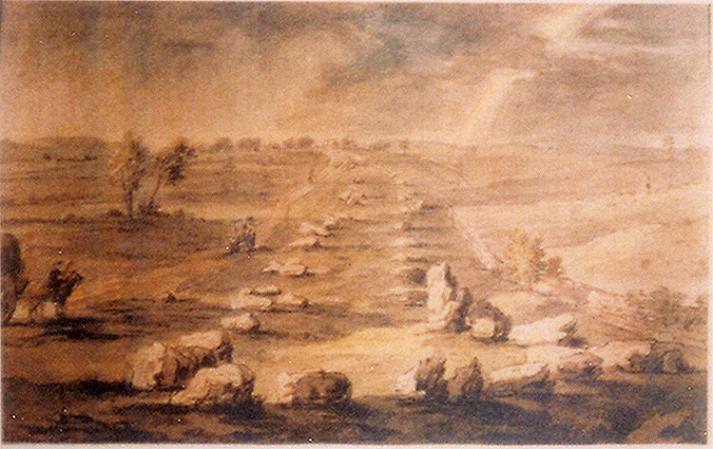
| "We should be hidden from their eyes, being but holy shows And bodies broken like a thorn Whereon the bleak north blows" from 'A Man Young and Old' W.B. Yeates "The largest stone circle near the English border—the Stonehenge or Avebury of the north of England—formerly stood near Shap. The stone avenues leading to it are said to have been nearly two miles in length. The engineer of the Carlisle and Lancaster railway carried his line right through the very centre of the ancient stone circle forming the head of the chief avenue, leaving a few of its huge stones standing out on the western side, where they may he still seen by the passing traveller about half a mile south of the Shap station. If the line had been laid only a few feet on either side, the wanton desecration and destruction of this fine archaic monument might have been readily saved. Railway engineers, however, and railway directors, care far more for mammon and money than for mounds and monoliths". Professor J.Y. Simpson M.D. December 1860 The village of Shap is located at the southern end of the Lowther Valley, 12km south of Penrith and 18km north of Kendal. Stan Beckensall writes that 'Shap' means a heap of stones ('Hepe in 1228). Other sources say that the 12th century name was 'Hepp' which means a heap yet another translates it as 'Hep', which is the same as hip as in the rosehip of the dog rose. I'd like to think that Stan's interpretation is the correct one. The area around Shap has been a focus of activity since at least the late Mesolithic. Cherry found over 2000 artefacts in 4 major concentrations around Wickers Gill, (just over a kilometre south of Kemp Howe). He describes the general background as being of 'Mesolithic appearance with Neolithic traits' he also found barbed and tanged arrowheads and pottery indicative of 'the late Neolithic and early Bronze Age'. Dating the avenue has proved difficult due the lack of dateable evidence. T. Clare suggested a late Neolithic date based upon his excavation of the Goggleby Stone and comparisons with other similar linear monuments such as The West Kennet Avenue. The antiquarian, Leland, visited the area in the 16th century and failed to mention the stones. A short while later, Camden visited Shap and recorded the northern stones as 'large stones in the form of pyramids set almost in a direct line and at equal distances, for a mile together'. Stukeley visited the site in 1725 and interpreted the avenues as a 'megalithic serpent', unfortunately the plan drawn up by his surveyor, Routh, is now lost. The earliest diagram I can find of the avenues is a painting of the southern avenue. I came across the painting on the Shap Community website (http://ShapCumbria.co.uk). The painting is unaccredited but appears to be based on a sketch that Burl has in his book 'Carnac To Callanish' the sketch is credited to Lady Lowther and dated 1775. The Shap Avenues — Images04.07.04ce
Through the centuries the Shap avenues have attracted many of the more notable antiquarians and archaeologists. This has left us with a record charting the destruction of this once spectacular monument. In 1777 Nicholson and Burn noted the blasting and carrying away of stone for the foundations of buildings. By 1824 G. Hall wrote about the destruction of the stones by enclosure. When Lukis and Ferguson review the evidence in the late 1800's 'there was precious little remaining other than the early and apparently conflicting accounts'. The antiquarian, Rev. J. Simpson was the Vicar of Shap in the mid 1800's; he described the avenue and gave an intriguing account, writing that from tradition there was a stone circle 400ft in diameter with a large stone at the centre. It's said that this huge centre stone was cut into 7 pairs of "Yat Stoops" or gateposts. . The Shap Avenues — Images05.07.04ce
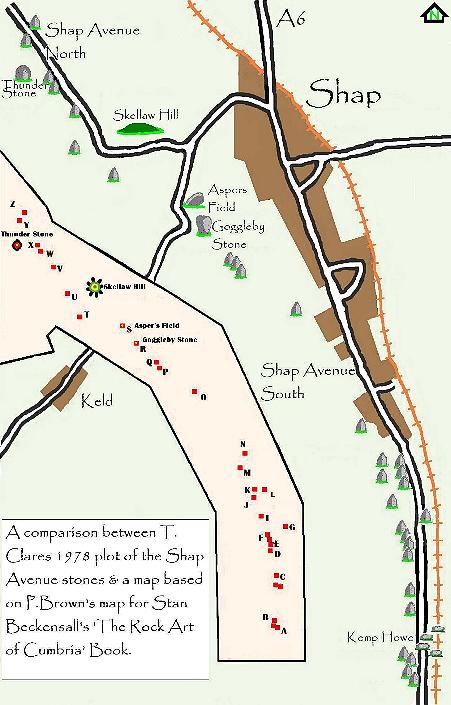
The Reverend Simpson was also something of a pioneer in the field of prehistoric rock art and was the first person to describe and draw the cup and ring marking on the Goggleby and Asper's field stones. Aubrey Burl describes these stones as "mistakenly claimed to be cup marked" an opinion which is not shared by Stan Beckensall who describes them thus " the symbols on the Goggleby Stone are a shallow wide cup mark with a smaller one beneath it on the vertical face of the stone. The Asper's Field stone, has a cup with a single ring on top". In the mid 1970's, T. Clare reviewed all of the published accounts of the avenues and tried to make sense of the conflicting accounts of the Antiquarians. His fieldwork led him to conclude that the apparently conflicting accounts of the avenues were in fact complimentary. The main difficulty with all of the early interpretations of the avenues was what Routh described as the 'remarkable turn' in the avenues course. Clare hypothesised that there could be two possible explanations for this turn. The north and south avenues were two separate monuments or that the Skellaw Barrow preceded the avenue and had to be avoided. He then concluded that avoidance of the barrow was unlikely and so chose the option of two separate avenues. Looking at the stones themselves further strengthened this argument. He stated that all but one of the members of the north avenue appear to be tabular in form whilst the members of the southern group were more diverse in form. He suggested that Skellaw Hill could have been a terminal along with the Kemp Howe circle. Aubrey Burl's favoured and as he puts it, un-dogmatic, interpretation of the avenues is 'To the north of the Kemp Howe there had been two single lines, the eastern beginning at the Goggleby Stone, and the other starting about 1000 feet (300m) to the WNW and stretching north-westwards for some 900yds (820m) passing alongside the Knipe Scar enclosed cremation cemetery with it's burnt human bones". Stu and myself have waded through this material and decided that the only way to sort it out was to get ourselves there and give the place a good coat of looking at. After a few false starts we finally made it. We decided to roughly follow T. Clare & P. Browns plans of the avenues and try and identify all the stones marked. The Shap Avenues — Images26.06.04ce
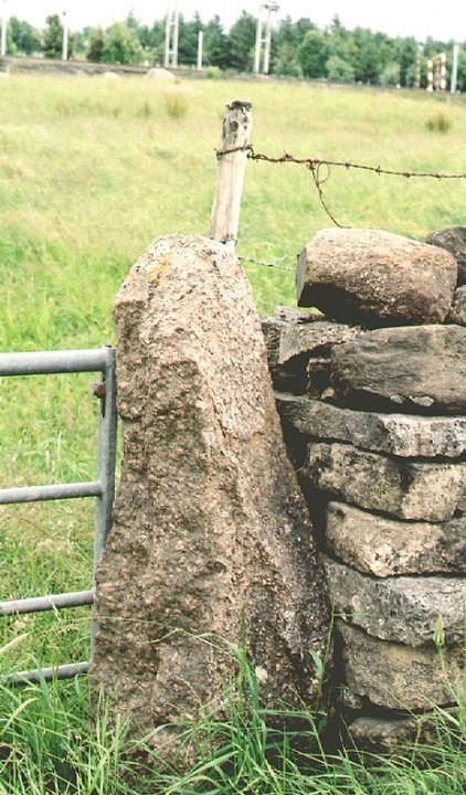
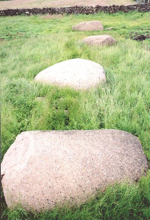
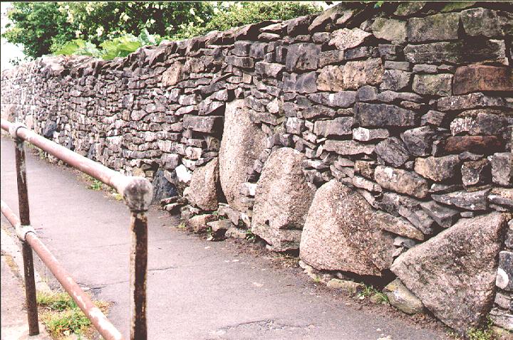
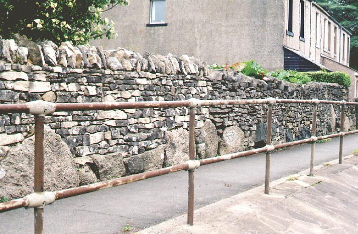
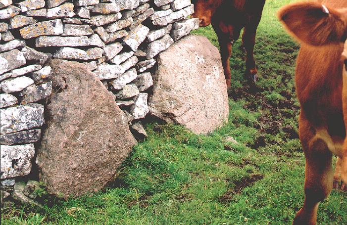
We decided to look mainly at stones made of un-quarried Shap granite. Shap granite is a magical rock, for the geologically minded amongst you, it is a biotitic granite with large crystals of pink, plagioclase feldspar, once seen never forgotten. It also seems to be the stone of choice for the stone circle builders of the eastern Lakeland fells. So down to the nitty-gritty. We parked up at the southern end of the village and started our search in the walls just south and on the opposite side of the road of Kemp Howe. Almost immediately we started finding large well-rounded boulders being used as footings for the walls. Stu reckons there were 6 there in total. To be honest with you I was preparing myself to not find a thing, so this was a wonderful start. We then crossed the road to Kemp Howe aka Karl Lofts aka the Liftings of the Husbandmen... yeh I know, I haven't a clue what it means either but in my Yorkshire dialect book, ' Kemps' means hair mixed with wool, clear as mud! The lovely stones of Kemp Howe sit beside the railway track and resemble a group of hippos wallowing in a sea of green. Kemp Howe — Images05.07.04ce
Julian Cope described Shap as "A whole community built at the expense of a mini-Avebury", this statement hits home as we sit in the ruins of this once-grand but now forlorn circle. The northern walls of this field reveal more stones in the footings. We left the field and head north along the A6. The area close to and around the Force Bridge revealed more stones including a large stone nestled amongst the trees beside a field wall west of the Force Bridge. The Shap Avenues — Images02.07.04ce
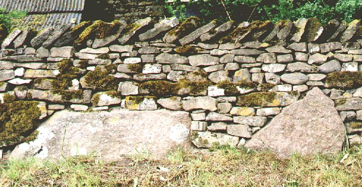
From here we had stones to the left and right of us. There was a large stone poking through the grass in Brakenber Field along with a number of stones in a field clearance, and then, suddenly we were faced with a whole wall full of stones. These stones had un-weathered faces but by looking at the sides of them you could see that these were not quarry stones but boulders that had been broken up. The Shap Avenues — Images02.07.04ce
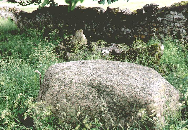
One of the beauties of granite is that it doesn't weather; a face that was broken 1000 years ago can look as fresh as a modern face. As an example of this, if you ever go to Aberdeen, check out the buildings there. The whole city is built of granite and it's only the differing architectural styles that reveal the true ages of the buildings. By now our heads were spinning, what we had found was greatly exceeding our expectations. Time for the pub. We called into the Greyhound Hotel to chill for a wee while and talk about what we were seeing. I can recommend the Tirril Brewery's lovely Bewsher's bitter. You can't miss it; they use the sanctuary knocker from Durham Cathedral as a logo. There is also the same knocker, which I presume is a copy of the original, on the huge gates of Brougham Hall and on my toilet door at home, but maybe that's just too much information. We needed to confirm that these were stones from the avenue. What started to convince us that these were indeed the stone was the fact that the local building stone is limestone. The granite was only being used a piece here and there. If it was coming from the quarry we would have expected to see worked stones or walls and buildings faced with this incredibly durable stone but this just wasn't the case. On leaving the pub, the same pattern continued, occasional stones in walls, the odd isolated stone in a field e.g. the large rounded boulder in front of Green farm, but they were becoming less frequent. It was at this point that we decided to start heading out into the fields towards the Giants Foot Stone. As we followed the footpaths we started encountering the same pattern of stones in walls that we had seen along the A6. At this point the plan of the avenue shows that it starts to veer away from the road and our observations seemed to confirm this. The Giants Foot is a beast of a stone, but its size was not the most significant factor, its shape was more important, it was tabular, an indication that something may have changed. So far the stones we had seen were rounded boulders. There are references in the various accounts of the pairing up of tabular and rounded rocks, perhaps to signify the male and female form. This was the first of this new type of stone, and what a cracker! Giant's Foot — Images02.07.04ce
As we moved along, gradually making our away up the low rise checking out the various stones in the wall and dodging inquisitive bullocks, we began to move towards the Goggleby Stone with the very low, subtle rise of Skellaw Hill beyond. The Shap Avenues — Images02.07.04ce
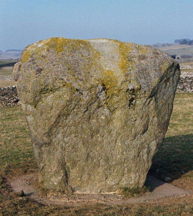
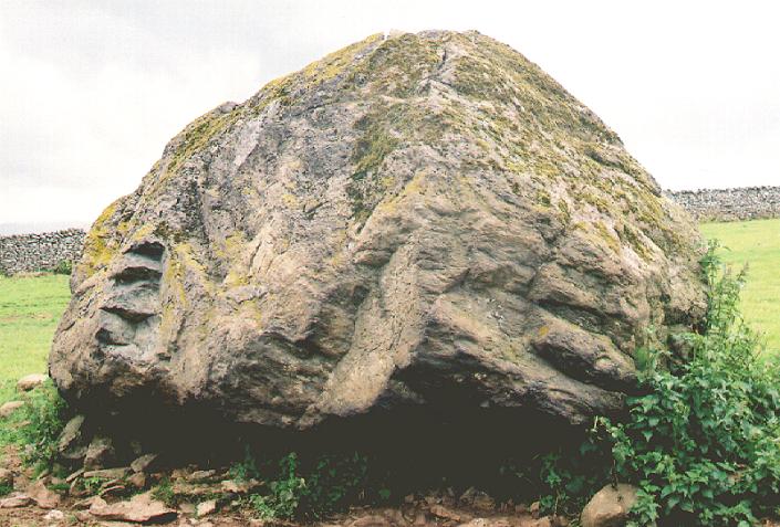
Burl describes the Goggleby stone as looking like a bulbous triangular avocado standing on its head. Burl's Avocado is a beautiful stone. In his stone row book he relates a tale that ' In 1834 the Rev. Bathurst Deane scoffed at the 'ridiculous name of the "Guggleby" stone, given to it by a facetious farmer some years ago to exercise the ingenuity of antiquarians'. As, over a century before, Stukeley had referred to 'one particularly remarkable, called Guggleby Stone' Deane appears to have been misled'. The Goggleby Stone — Images24.02.03ce
Stu and I discussed the possible origins of the name. One idea that came to mind was that of Gog, the ancient British God, who according to T.C. Lethbridge, is also known as Og, Hog (remembered at Hogmanay). He describes Gog as "Perhaps originally a bodiless deity corresponding to Brahma and the force at the back of all things. Later seems to have become identified with the sun and either the husband or son of Magog". Magog is the Earth Mother and Moon Goddess in her old phase. She is also known as Magg, Meg, Matrona, and Maha-devi etc. She may also be the Cailleach and is sometimes represented by a standing stone. Stu pointed out to me, that in Paul Newman's book, The Lost Gods of Albion, Newman writes that "Gog is a version of Ogmios, a Herculean divinity equated with the glare and dazzle of the sun - hence the word 'goggle'". The Goggleby Stone is a marvel in itself, but Stu and I were keen to get to Asper's Field and get to grips with the cup and ring. We checked out the fields and looked for the easiest way to access the stone using the various gates. I'm afraid we didn't gain permission from the farmer because we didn't have a clue who to ask and as there was no livestock in the grassy field, we thought no one would mind. Before the next stage of the journey, a word of warning. If you are planning to use the footpath from the Goggleby Stone to Skellaw Hill I would advise you to wear a pair of wellies, waders would be better. This path in parts is a quagmire and a real test of determination but if you do make your way along it you'll see a couple of lovely, great big stones embedded into the wall. Skellaw Hill is generally a bit of a disappointment. Unfortunately 'The Hill of Skulls' has long since lost its 'sepulchre' status and was reduced to a small mound following the enclosure of the common in 1815. If you didn't know it was there... But fear not, this was an important part of the northern avenues and an integral part of the whole monument. There's one issue on which we disagreed with previous surveyors of the avenue. Everyone seems to agree that the avenues avoided Skellaw Hill, but if you look in the wall just below the hill, you will find a large embedded stone that is perfect alignment with Asper's Field and the Goggleby Stone. Skellaw Hill — Images24.02.03ce
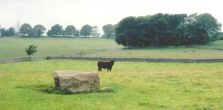
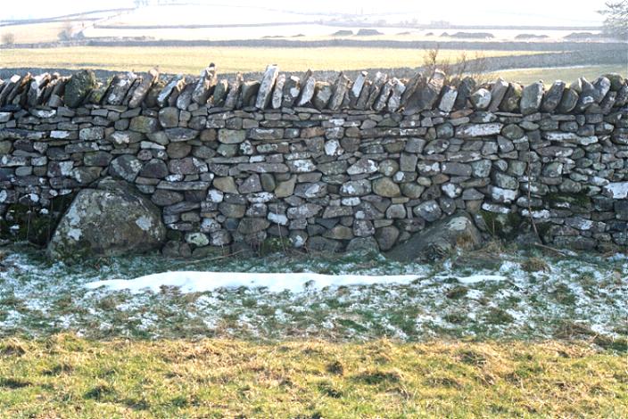
From here it is fairly plain sailing, we followed the road heading towards the Thunder Stone checking out the field walls and finding a number of good-sized stones poking out of the walls and grass. At the entrance to High Buildings Farm you can see the Mighty Thunder Stone in the field ahead. We walked up to farm and the friendly farmer allowed us to mooch through his field to the stone. This rock is the size of a car. The Goggleby stone weighed in at 12 tons so what would this weigh? "No wonder folk thought that these stones fell from the sky," remarks Stu. Put yourself in the days before folk knew about glacial transportation. You've got this bloody great stone in the middle of a field. How did it get there? A Thunder Stone indeed. Thunder Stone — Images02.07.04ce
In the opposite corner of the field, close to the road is another good-sized stone but nothing on the scale of the mighty Thunder Stone. In the field beyond we came across the area described by Clare as "disturbed ground amongst which the remains of old enclosures (associated with quarrying?) can be discerned. This area would equate with the four ovals or circles of Routh and the square plots of stones nearly covered with earth, of Hodgson which are considered to be the northern terminus". As we walked back into Shap village from the north another piece of the jigsaw fell into place. The houses and walls of the northern two thirds of the village are almost totally free of granite. The walls are topped with beautiful gnarly limestone but no boulders, no footings. At the point where the avenue leaves the village, the use of granite stops. The implication here is that all of the granite we encountered in the southern end of the village has been gathered from the fields. Burl writes that there were 500 stones in the avenue, I'm not sure where he gets this figure from but given the length of the avenues, it seems reasonable. If this figure is true then we have seen evidence of about 1/10th of these stones. The rest, we must assume are now part of the fabric of the village, foundations for walls and houses, drainage channels and road stone. So what can we say about Shap? Yes the avenues would have been magnificent, but more than this, Shap appears to be the significant part of a prehistoric Cumbrian monumental landscape. This is a landscape that exists in a corridor between the western margins of the Pennines and the eastern margins of the Cumbrian fells. This landscape seems to be associated with the three interconnected rivers, which run through it, The Rivers Eden, Eamont, and Lowther. If we start at the ruined stone circle and stone row of Grey Yauds and then move along the Eden to the ruined complexes at Broomrigg, the monuments of Old Parks,Glassonby, Long Meg and Little Meg. We then come to the junction of the Eden and the Eamont, if we follow the Eamont for two miles we come to the junction of the Lowther and the crossing point at Eamont Bridge with the triple henges of Mayburgh, King Arthur's Round Table and The Little Table. Follow the Lowther south past the standing stones of Clifton, the Long barrow of Low Moor, the Moor Divock complex which includes another series of stone rows, the circles and enlosure of Knipe Moor and the nearby circles of Shapbeck Plantation, Wilson Scar, and Gunnerkeld. These monuments are all north of Shap and roughly follow the river systems. In the hills surrounding Shap itself we have the prehistoric stone circles and cairn circles of Castlehowe Scar, Iron Hill and Oddendale. An interesting aside to all the followers of Julian Cope's research. The Dr. J.Y Simpson refers to Oddendale as "Odindale" and the nearby barrow of Seal Howe as "Sill Howe". The source of the River Lowther lies just south of Shap in the area where I began this article, Wickers Gill, a Mesolithic site. So what was happening here? Judging from the amount of monuments, there seems to be a huge amount of ritually related activity taking place in the late Neolithic and early Bronze Age. Were people coming into this area from other parts of the British Isles? I believe they were. I base this upon my researches, visits to the area, looking at the different styles of monuments and tracing possible routes of communication between Cumbria and the rest of the British Islands. Why were prehistoric peoples coming to Cumbria? Its location in the centre of the British Isles is ideal, especially if you are navigating the western seaboards or crossing from Ireland to continental Europe. There is also a lot of evidence which points to the movement of stone axes out from Cumbria. Cumbrian stone axes have been be found throughout Britain and Ireland. A lot of research has been undertaken into the production and distribution of stone axes, I don't really want to explore that here but if you want to look into this subject further then Terry Manby's paper, 'The distribution of rough-out "Cumbrian" stone axes', is a good starting point (see references). I was recently asked, why are so many of these monuments dated to the Bronze Age, a time when the production of stone axes was in decline? I believe that the ancient Cumbrians were prospectors, craftsmen and traders. They originally explored and exploited the fells for rock that was suitable for making tools such as axes, but as the demand for stone tools fell into decline, the native Cumbrians embraced the new metal technologies and built upon the trade links that were already established with the rest of the Islands of Britain and beyond. Veins of copper, lead and silver that can be found in various locations throughout the fells would probably have been known to many people. There is evidence of prehistoric copper extraction at Coniston. This may have been a natural progression. The quarrymen may have become surface miners and the knappers may have become metal workers. One hint of this may be Stukeleys report of a 'bronze celt' (probably an axe) found ritually buried in the entrance to Mayburgh Henge 10km north of Shap. Of course none of this is certain but it's the best I can come up with given the evidence I have. Finally I would like to say that I agree with Mr Cope's statement that Shap is a "Mini-Avebury". It is still a magnificent Cumbrian monument set in a spectacular landscape. More significantly for me, it is a place that is free of the new-age frippery that you encounter at so many of our ancient British monuments. Long may it stay that way. Fitzcoraldo July 2004 Updated October 2004 The SMR lists stones at the following grid references NY55171592, NY55151574, NY55551528, NY55551526, NY55841520, NY55921509, NY56051496, NY56031477, NY56611436, NY56591425, NY56741411, NY56751410, NY56761409, NY56741409. To add these Stu took the following references on his trusty GPS. This doesn't cover all of the stones that we found but it is a good starting point. NY5673613194 to NY5673713308. The stones opposite Kemp Howe NY5656813841. The Force Bridge stone NY5659414220. The Green Farm stone NY5656814378 to NY5650314574. The central stones in the wall side. NY5629314819. The bullock field stones NY5564115433. Two stones on the roadside below Skellaw NY5555315278 & NY5555713264. The two stones north of Asper's Field next to the quagmire NY5527915783. Stones close to the Shap Abbey junction. NY5527915783. Stones in a field clearance. NY5527015828. Wall stones NY5521215932. Two uprooted stones. References Prehistoric Rock Art in Cumbria Stan Beckensall Tempus Publishing 2002 From Carnac to Callanish. The Prehistoric Stone Rows and Avenues of Britain, Ireland and Brittany. Aubrey Burl Yale University Press 1993 The Stone Circles of Britain, Ireland and Brittany. Aubrey Burl Yale University Press 2000 Field Walking in Cumbria James Cherry Current Archaeology 115. June 1989 Recent Work on the Shap "Avenue" T. Clare Transactions of the Cumberland & Westmorland Antiquarian & Archaeological Society Vol LXXVII 1978 Archaeological Sites of the Lake District T. Clare Moorland Publishing Co Ltd 1981 The Modern Antiquarian Julian Cope Thorsons 1998 Gogmagog. The Buried Gods T.C. Lethbridge Book Club Associates 1975 The distribution of rough-out "Cumbrian" stone axes T. Manby Transactions of the Cumberland & Westmorland Antiquarian & Archaeological Society Vol LXV 1965 Lost Gods of Albion. The Chalk Hill-Figures of Britain Paul Newman Sutton Publishing 1997 The Shap Community Website http://ShapCumbria.co.uk Stone Circles Near Shap, Westmorland Proceedings of the Society of Antiquities of Scotland Vol 4 1860-62 Rev. James Simpson On the Sculpturings of Cups and Concentric rings Proceedings of the Society of Antiquities of Scotland Vol 6 1864-66 Rev. James Simpson Address on Archaeology Proceedings of the Society of Antiquities of Scotland 1860 Prof J.Y. Simpson Stanfords Geological Atlas of Great Britain Edward Stamford Ltd 1964 The Cumbria Directory http://www.thecumbriadirectory.com/ W.B. Yeates Selected Poetry Pan Books. |
 Posted by fitzcoraldo
6th July 2004ce Edited 30th July 2006ce
fitzcoraldo's TMA Blog
Latest TMA Blog Posts
|
Comments (0) |
|
| You must be logged in to add a comment | |