|
|

|
thesweetcheat’s TMA Blog |
|
Pleasant Valleys Sunday - Between Sirhwyi and Rhymni 30 January 2022
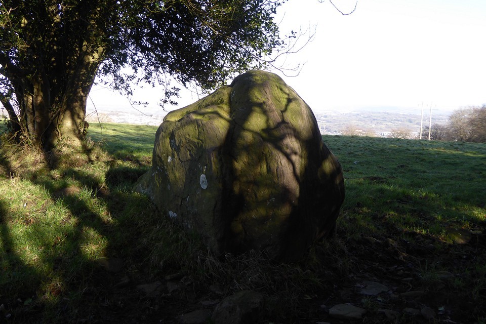
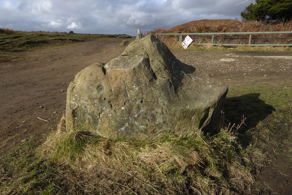
| Back in the 2010s I was slowly exploring the prehistoric archaeology of the steep-sided ridges above the towns and villages that make up the South Wales Valleys. After visiting most of the cairns and occasional standing stones above the Rhondda and Cynon rivers, I got distracted and my trips out to these largely ignored sites dwindled. 2020 marked a year of stagnation, with Wales mostly unreachable, but a beautiful hot day in spring 2021 found me hanging out above Blaenavon, at the easternmost end of the Valleys. It was enough to rekindle a feeling that there was a lot still to visit here. Last weekend finally saw me properly re-engage, in a strenuous but very rewarding horseshoe walk above Ebbw Vale, taking in solitary cairns on two of the high ridges that mark the northern frontier of the Valleys. Today I’m going for something shorter, lower, and with more archaeology, on a ridge that Carl trailblazed for TMA a decade earlier. A quick glance at the map reveals a potential embarrassment of riches in a relatively small stretch of ridge between the lower Rhymni and Sirhwyi valleys, ending with the prominent summit of Mynydd Machen, an obvious landmark from both the Gwent Levels to the south and from the magnificent Twmbarlwm hillfort across the valley northeast. So it’s an early start for a Sunday; a saunter through a bitterly cold and largely deserted Newport city centre, then a bus towards Blackwood has dropped me below the small hamlet of Wyllie, nestled on the side of the ridge above Cwm Sirhywi and a good place to start the walk from the northwest. Despite the low temperature and the open windows that kept the bus ride cold, it’s a steepish climb up to Wyllie and I’m soon feeling warmer than I might have liked. The winter sky is clear blue, with the low sun raking through the trees framing the slightly sunken lane leading me onto the ridge. I’d done my homework for once, and Historic Wales has turned up a possible standing stone right next to my route. Tyle-gwyn — Fieldnotes15.01.23ceTyle Gwyn (“White Bank”) stone turns out to be a big upright lump of sandstone. It’s one of those stones that looks too improbably erect to be natural, but too bouldery to be an obvious choice for a menhir. The stone is close to the lane, with a barbed wire fence between it and me. The field has cattle and some farm workers are repairing fences across the way, so I decide not to make the effort of trying to get any closer. The contrast between the sharp shadows of the lane and the brightness of the field and hills beyond makes getting any decent photos difficult, but it’s a worthwhile stone to come and see. Given the prevalence of South Wales’ standing stones marking apparent routes to upland stone circles and cairns, I can’t help but feel nudged towards accepting this as the real thing and not merely a natural erratic. It certainly sets me on my way with hope for the monuments to come. Tyle-gwyn — Images08.01.23ce
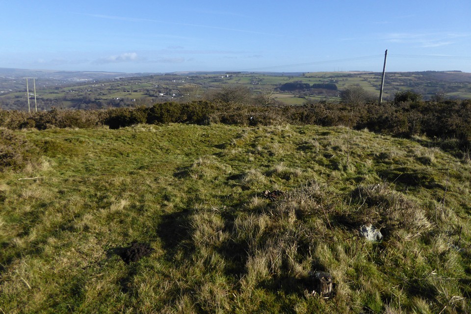
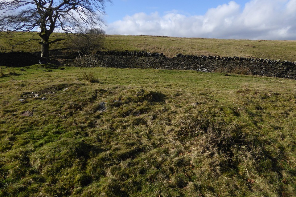
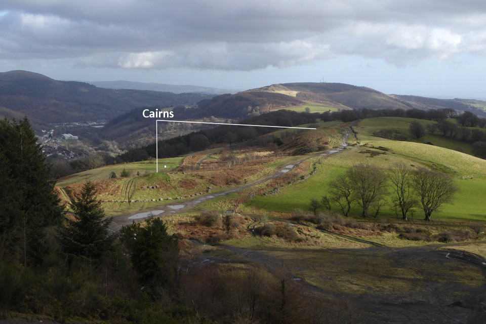
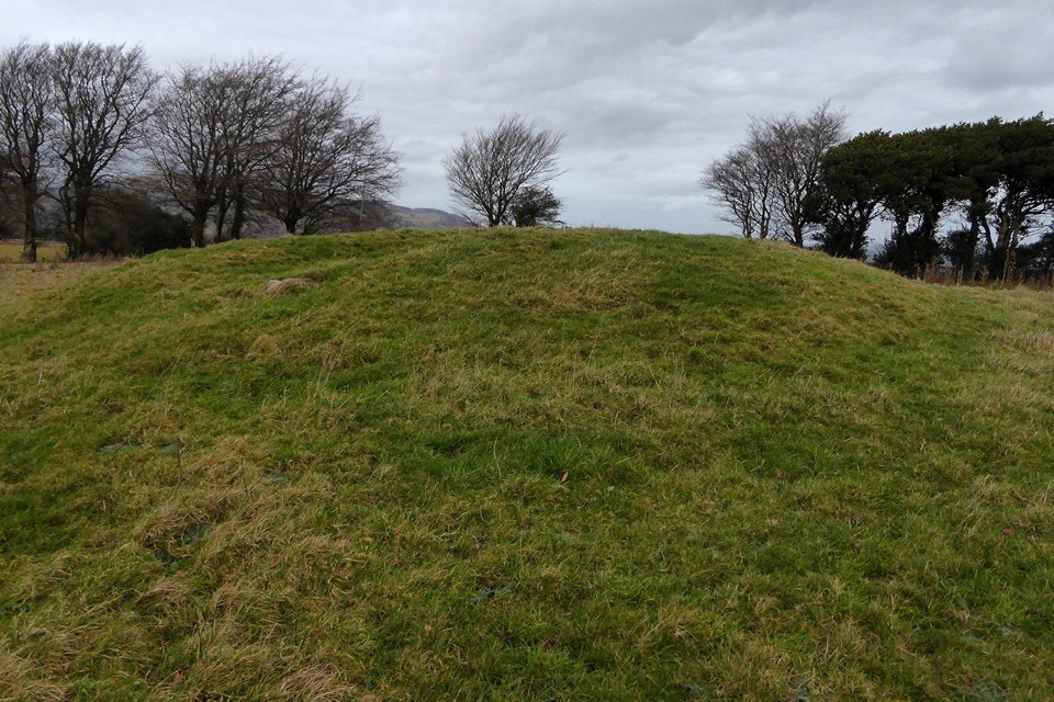
Not much further on, the end of the lane brings me out onto the ridge proper, and I head south on the minor road that will take me to the access land. The views eastwards have now opened up, particularly of Mynydd y Lan across Cwm Sirhwyi, which has its own unmarked cairn (one for a future trip). There is vehicular access along the ridge, the main restriction being whether a car’s suspension will handle the deep ruts and watery potholes. It also makes for a lot of motorbikes, some of which are being ridden responsibly, others less so. As I saw above Ebbw Vale last week, there is an ongoing threat of damage here from people who don’t know or don’t care about the ancient heritage on these ridges. Mynydd Bach (Maesycymmer) — Fieldnotes15.01.23ceThe first cairn of the day is Mynydd Bach 2, a low monument marked on the Ordnance Survey map. It sits in an area of gorse and scrub, criss-crossed by various tracks and I’m not particularly optimistic that it’s going to be easy to find. I follow one of the broad tracks running west from the main ridgeway, then another heading south. And amazingly, clear of the thick gorse smothering much of the area, here is the cairn. As described in the HER, it’s a low, circular monument. It rises highest above the surrounding ground surface on its eastern arc. I wouldn’t be surprised if it has always been a low monument, rather than the remains of a bigger robbed-out mound, as there are other ring cairns close by. From here I can see the obvious profile of Mynydd Machen, which is on the agenda for later. Apart from a couple of stones protruding where gorse bushes have been cut back, the monument is covered in turf. Close by are signs of rubbish or motor debris having been burned, but at least it’s not happened on the monument itself. Although it’s not the most exciting cairn, I’m delighted to have found it so easily and drink in the extensive views. Next I head into the scrubbier ground to the west, where there is supposed to be another ring cairn, unmarked on the OS map. After wandering for a bit and poking around in the gorse and tussocks I declare this one a failure. There’s plenty more to come, so I’m not too disheartened by this setback. Returning to the main ridge path, the next cairn south (Mynydd Bach 1) is much more obvious. It lies in a grassy field to the west of the access land, and can be seen prominently from the path. The unexpected obstacle to this one turns out to be resident sheep, who take curiosity to heights bordering on belligerent, crowding around right behind me as I cross their field. To be fair I’m intruding on them, but it’s like something between panto season and Life of Brian; my attempts to convince them that I am not the messiah are unsuccessful. They follow me all the way onto the cairn itself, which makes taking photos somewhat difficult as I’m constantly on the brink of being pushed over from behind by whichever sheep is the bravest of the flock. Nevertheless, this invasion of my personal space doesn’t detract from what is a fine monument, with a cist exposed in its centre. Two side slabs remain, one still in place, the other lying out of position. There’s a bit of rubbish too, unfortunately, although by local standards it’s quite minor. A further small slab lies on the northern edge of the mound, but I’m not convinced it would have been large enough to be the capstone. There are fine views to the northwest, looking towards the higher ridges. To the west Cwm Rhymni drops away. If you can shake off the sheep, this is a very decent monument to visit. With my retinue following me to the fence, I head south. Leaving them behind, the ground drops quite steeply and according to Coflein (but not GGAT) there is supposedly another very irregular cairn here. Apart from an area of stone exposed from quarrying, I can’t find anything at all in 10 minutes or so of walking backwards and forwards across the sloping field, so I give up and head back to the ridge path. The next monument, Pont Bren Gwyn ring cairn, sounds like it will be elusive. However, the OS map is helpful in showing an obvious kink in the wall right where it’s supposed to be, and so it proves. Beneath a lone tree, with a broken wall on its west side, the arcing bank around the east side of the monument is quite easy to make out in the low sunlight and low vegetation of this time of year. Definitely one for the enthusiast, but like Mynydd Bach 2 it’s the sort of monument that gives a sense of satisfaction just from finding it at all. The name defies my attempts at translation; although it sounds like it may be related to “Brenin”, it seems that “Bren” may be a proper noun, which would make it “White Bren’s Bridge” I think. Like Mynydd Bach 2, the views are all eastwards, towards Mynydd y Lan. All in all this little group of sites has been a great start to the walk. There are plenty of other people out enjoying the winter Sunday sunshine, but no-one seems overly interested in these obscure lumps and bumps. No change there! Mynydd Bach (Maesycymmer) — Images12.01.23ce
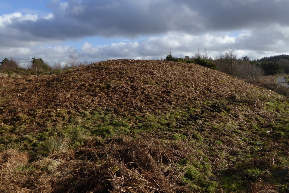
Twyn Cae-Hugh — Fieldnotes15.01.23ceHeading southeast, the main ridge path starts to climb gently up towards an area of forestry on my left. And rising rather majestically from the forest’s margins is the biggest barrow so far by some distance, Twyn Hugh-Cae (“Hillock of Hugh’s Enclosure/Close”). When Carl visited it was covered in summer vegetation, but today it has been close-cropped, probably by someone with a strimmer. The fence at its foot has been broken and there are worrying signs of bikes tracks cutting into its edges. Nevertheless, this is a big, impressive monument, regular sides sloping up to a flat top. On further investigation, the summit of the mound has been dug deeply into, a wide crater exposing earth and roots but no sign of any central chamber or cist this high up in the barrow. The construction appears to be more earth than stone. Views to the south are truncated, but the barrow has decent views north across Mynydd Bach (Maesycymmer) and beyond. Across the main track to the west is an area of open ground, which hides the low banks of a square-cornered earthwork. The shape suggests it’s medieval or later, but it’s curious how close it is to the massive barrow and I wonder if it’s related to the site’s name. Immediately south of the barrow is a pointed standing stone. None of the HER records mention it, and it’s far too obvious to have been overlooked so I assume it has been taken to be modern. However, it’s a nice slab of sandstone and all its sharp edges have been worn smooth in a way that suggests it has been exposed for a long time. Hmm. Twyn Cae-Hugh — Images15.01.23ce
The main ridge path continues to head southeast, the ground rising ahead of me. The surface is becoming increasingly rutted and muddy, and the rising ground to my right has turned into a blighted landscape of churned, black earth. This is Mynydd y Grug, where the natural surface has been raised to a much greater height by the addition of mining or quarrying spoil. I slog my way up to the top to get a sense of the views. The top is gradually becoming vegetated, and I guess that in a few years this dark mass will blend more naturally into the wider landscape. It is worth coming up to the top for the elevated views the artificial height provides of my next objective, the pair of cairns or barrows at Twyn yr Oerfel and onwards to Mynydd Machen. Above the Sirhywi valley I can also see the round prominence of Twmbarlwm rising forbiddingly. Twyn Yr Oerfel — Fieldnotes15.01.23ceWhen Carl visited Twyn yr Oerfel (which appears to translate as “Hillock of Chill” or “Cold Hillock”) he expressed concerns about the barrows being damaged by motorbikes. From my elevated vantage on Mynydd y Grug I can see that the nearer western monument has now been encircled by a double ring of stone blocks, presumably to discourage vehicles from encroaching. After making my somewhat slip-sliding descent from the spoil, reaching the western cairn reveals an excellent monument. Although there are ruts from wheels cutting its side, they appear to be mostly old and are being slowly grassed over. The mound stands to a good height and doesn’t have the usual signs of antiquarian digging in its top. Best of all though is the view. Perched right on the edge of steep slopes of Cwm Sirhwyi, the cairn enjoys a brilliant vista to the north and east. It’s a shame it’s been badly treated, but don’t let that put you off, it’s a cracking site. The eastern cairn is similarly poised above the drop. As I approach a number of motorbikes zip along the ridge path towards me, thankfully ignoring the mound which stands next to the track. Like the cairn I visited on Y Domen Fawr last weekend, this one has had the ignominy of a wooden bench being inserted into its top. Fair enough, the view is superb, but surely the Powers That Be didn’t need to actually stick the bench right on top of the cairn? The feeling persists that there is a lack of care or concern about the preservation of the heritage these monuments represent. Whatever, this is a great pair of monuments; in terms of placement these are the best-situated cairns on this ridge. I stop here for a while and have a late lunch (yes, I am sitting on the bench). Twyn Yr Oerfel — Images15.01.23ce
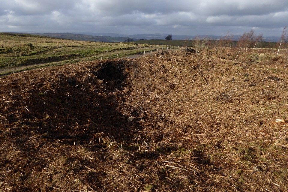
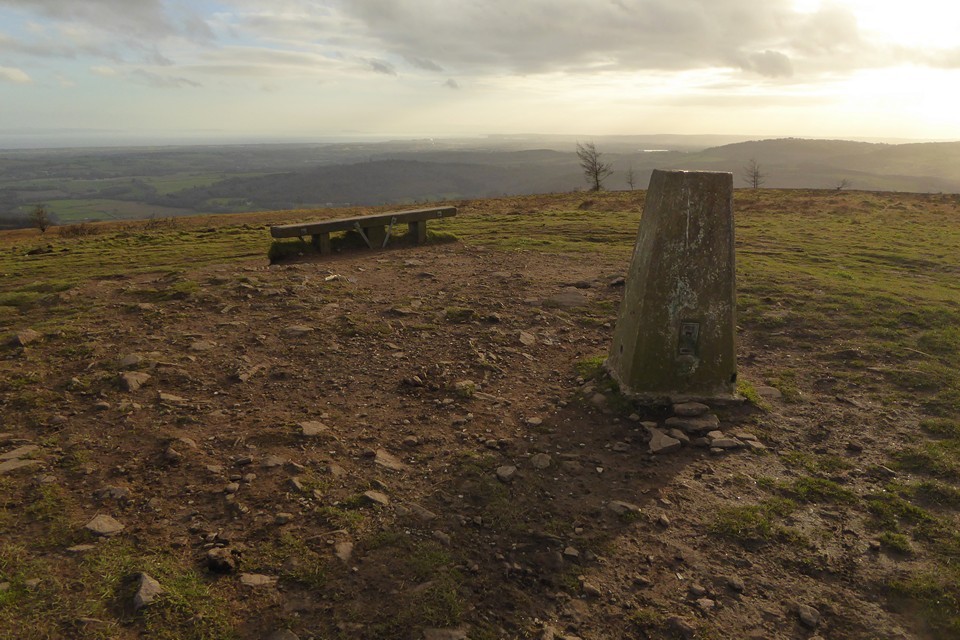
At length the need to get going again kicks in, I still have one biggish hill to climb before I’m done. I leave the main ridgeway before it turns back into a road and instead head northeast along a pleasant tree-lined track north of Penllan Farm. Eventually I reach a road and forestry parking area, busy with Sunday walkers. Eastwards the ground now rises steeply, and I’m huffing and puffing a bit as I reach the open land next to the extraordinary man-made ridge of Pen-Rhiw Tip. Although it’s a blighted landscape, it is slowly reverting to nature and the tip itself is worth a walk along for the excellent views it provides across the valley towards Mynydd y Lan and Twmbarlwm. The eastern end of the ridge is rather steep and loose, as I discover when I try to get back down from it! Mynydd Machen — Fieldnotes15.01.23ceThe final hill of the day is now directly ahead of me. It’s not that steep a climb from this direction though, and the going is easy. I reach the summit area next to the masts to find a few other people up here, enjoying the last of the sunshine, which is rapidly giving way to an overcast evening as the sun sinks behind low cloud. There’s also a 4x4 parked up, overlooking the much steeper drop eastwards. The cairn is another fine one, but judging by ruts and loose stone on its top and sides it’s being actively damaged by vehicles. It’s a real shame, as the placement here is terrific. Although visibility has lessened with the cloud, there’s still an amazing panorama looking south and east across the Gwent Levels to the mighty Afon Hafren (Severn), with the instantly recognisable Flat Holm and Steep Holm islands. While I’m taking photos, the 4x4 pulls away from the edge of the drop and comes and parks up right on top of the mound next to me. The driver and passenger grin idiot grins through the window at me, I’m sure they think they’re very clever. I carry on taking photos, now with the 4x4 as an additional feature. Belatedly realising that number plates can be traced, the driver decides he’s had his fun and drives away off the hill. It’s left a sour taste at the end of what has otherwise been a fine ridge walk. It’s so frustrating that people like this are wrecking the excellent archaeology around here. With them gone, I enjoy the last sun rays on the barrow before making my way down the steep slopes to the east. Mynydd Machen — Images15.01.23ce
Off the hill, my route carries on southeast, and there’s one further site to fit in as the sky darkens and evening approaches. Twyn Pant-Teg — Fieldnotes15.01.23ceI wasn’t necessarily expecting much from this, a barrow in a field with all the attendant risk of being ploughed down to nothing. It comes as a very pleasant surprise to find this is a very decent monument, a good upstanding mound with a few stones embedded in its top and sides. As Carl notes, there are good views down to the valley below; the Rhymni valley in this instance, as this barrow is at the top of a southwest-facing slope, unlike the other monuments I’ve visited today. The name (“Hillock of the Fair Hollow”) seems very apt. It’s a great site to finish the day despite the failing light, and lifts me after the irritation of my experience on Mynydd Machen. Twyn Pant-Teg — Images15.01.23ce
The last part of the walk is down very steep roads into Risca. The rain, which has held off all day, arrives as I cross the Afon Ebbw and head for the bus shelter. It’s been a very pleasant Sunday in the Valleys. The walks around here are often superb despite the human damage inflicted on the landscape. It’s just a shame that these visits often include brushes with an idiot mentality that can’t or won’t see that there is fine heritage worth preserving here. Never mind, there is beauty here for those that have eyes to see it, and that will be enough to bring me back to these ridges, time and again. |
 Posted by thesweetcheat
15th January 2023ce Edited 15th January 2023ce
thesweetcheat's TMA Blog
Latest TMA Blog Posts
|


Comments (5) |
|
| Very much enjoyed reading your blog and tracing the route, thanks to good old google maps, as well as the sites themselves it looks like you had some incredible views along the way (Motorbikes and 4x4's excluded). Nothing like a cold crisp day for walking the hills. |
Posted by costaexpress 17th January 2023ce |
| Great blog, it was a good trip to follow :-) |
 Posted by thelonious
17th January 2023ce |
|
Thank you both, I really appreciate you reading it. I'm very rusty at writing stuff on here, so it's good encouragement if someone is reading! Costa, yep, it's a great landscape for all its faults, and some really nice striding out country once you've made the effort of climbing out of the valley. |
Posted by thesweetcheat 17th January 2023ce |
| Just read that SC, don't know why I didn't read it before. Always a pity about the 4x4s etc, but a great read and like, up here, these places keep drawing us back. |
12th April 2023ce |
| It's too hard to resist! |
Posted by thesweetcheat 12th April 2023ce |
| You must be logged in to add a comment | |