|
|

|
wideford’s TMA Blog |
|
April 9-15th 2005 HILL HEADS & BORROWED STONES
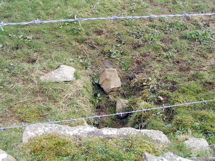
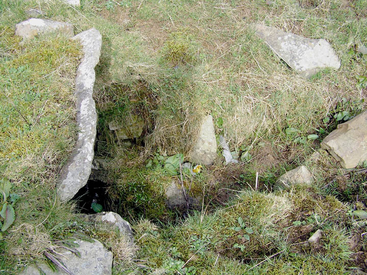
| Coming out of Kirkwall on the South Isles road I was on the lookout for three wells shown on the 1882 O.S. map. The first of these was marked just past the last of the Highland Park buildings on your left. It had occupied the tongue of field roadside between this and the Rosebank track but I could discern no trace now. Over on the right Hillhead of Crantit tops the slope. In front of this a quarry was shown in 1882. A very small one it must have been as it is shown (HY45720933) by one of those curious lobes seen also on that early map in front of the Wideford Hill quarry roadside (like almost every stream is a drain all rocky outcrops seem to be portrayed as quarries though, with the few odd exceptions). Perhaps as there it only indicated an end of any quarry - this could have subsequently 'lost' when the new distillery buildings were constructed here. The teeny bit of earthworks here is certainly artificial. Of the carved stone balls that have the name Hillhead House attached one pair have Hillhead of Crantit (as distinct from Hillhead) as an alternative name. If this were actually so could they have come from these quarry workings, as with the Westray Stone ? Or else from a bigger earthwork t'other side of the old house boundary ? The site is now more of an enclosure as only a few courses of the wall remain and it is all very overgrown between the fieldwalls. It looks as if some later concrete structure (?wartime) was built outside the actual house, as some sort of dump fills most of the rest of the space. The second of my wells (HY45110928) should be over the other side of the road from where the house boundary starts. There is a gate in the wall that would provide access, and the well would be at the start of a long rectangular depression the other side of the wall. My instincts tell me that though this field appears to go with Mayfield Farm at one time (before the road bisected the area) this section was also part of Hillhead of Crantit,as it is the same length. I did not see the well. The 1882 map shows linear features lining the depression, either walls or tracks (at the top end a solitary slab peeks but may only indicate the presence of a rocky outcrop).I looked for the well within the depression but actually the map shows it at the end of one of the linear features, this one running a little past the lower far corner downhill. From viewing the top end over the road to the end of the Hillhead of Crantit boundary. The earthwork past this is shown on the 1882 map without legend of any kind. The featureless oval depression (HY45090924) is about 22m long and therefore (from the map) around 8m wide. One can imagine this having been 'excavated' down to the ground in early antiquarian days. It does not appear on CANMAP. And given the paucity of information why should it. The third well shown along this road (again not on CANMAP) is opposite the existing Hillhead further uphill.[If both Hillheads bore carved stone balls it could represent a larger settlement than Skara Brae (from which another four of Orkney's total of fifteen came) even if of a rather different character. Though lumps and bumps do occur between them given the distance I see the two Hillheads as essentially seperate sites. Most likely it is simple confusion that has Hillhead of Crantit as bearer of one of the relevant NMRS records for Hillhead House. They are looking into this]. It had been my hope that this no longer existed, making it the well destroyed in 1872 that had produced one of the stones close to. But I was to be disappointed in this - but wonderfully so. From opposite the Hillhead House junction with the main road another 36 metres brings you to where a stone slab sticks out about a foot from the roadside wall partway up. And this functions as a stile to reach the well (HY44970849) just the other side. Looking over you see a wide white slab extending from wallbase level and below that a funnel shape [passage?] going forward at the field's ground level. I snuck myself into the space beween drystane wall and barbwire fence. The funnel shape is wall-lined and might have gone lower once. It proved a tight squeeze to shuffle along enough to get it all in frame with either camera. The digital still camera's batteries went before I bent over far enough to see inside. Leant over far enough with the barbire's support for the digicam to show a back wall. Looked more like a chamber than a well. Brown stones and I thought there was a curve, but not sure of my orientation at the time in order to say where in the structure (though the word apse came to mind). There was a place lower down the hill I could have gone under the fence but the only other apparent way in, a simpler way, is from the far corner going all way around the field. Some other time, like Hillhead itself. Another day I took a few hesitant measurements despite the wind. The slab is 0.9m across, though another stone may take the 'lintel' to 1.2m. From there to (present) ground level is 0.8m. At this point the 'channel' is 0.6m between its walls then funnels out ever so slightly till what can be seen peters out after another 1.5m. Perhaps originally more than a well? My last visit from inside the field I measured the well as going 0.7m back and presently 0.9m deep. Near the bottom at the back there is a red clay drain. As the whole alignment of the well, including the back wall, is very different from that of the fieldwall and road above it certainly precedes them both, with the small bore pipe is a fairly modern addition. For a while I entertained hopes that the Hillhead enclosure might at one time have held up to its previous billing of fort from the 1882 map's almost complete circle. My thought had inclined brochwards until my archaeologist friend, and fellow brochaholic, pointed out that even though it gave a magnificent view of Scapa valley from Kirkwall all the way up the Flow there was no complete 360 degree lookout. Then in the last fortnight I read where archaeologists say there should be a broch this side of the Scapa Flow (though there is a longer stretch of high cliff too in comparison to the Lingro side to make up for this percieved lack, surely ?) and I reconsidered that possibility. The same article had mentioned Knarston and Gaitnip as likely locations [a propos of Gaitnip, Mark Stone Moss I today discovered is named after two stones because on the first O.S. map there are Mark Stones of Gaitnip HY44700607 and Dalespot HY45690594 at turns on the St.Ola boundary]. Actually if there is a 'missing' broch I root for Borrowstone Hill as the location. Upon first seeing the name Borrowstone Hill one's first thought is of standing stones. But etymologically the name means hill of the township fortification. And I know of at least two brochs with 'borg-tun' names. So at the very least a fortified farmstead for Borrowstone where the records nothing of any kind left. On the present 1:25,000 map a field fence of several sides (HY44870768) intrigueingly resembles an incomplete circle with several structures within. Unfortunately for this position the early map only shows a bifurcating track and the still shown well. So time to investigate, my simple idea being that the strange shape arose from building work coming up against unmarked obstacle such as ditches or walling. No signs of anything to constrain the shape and the structures were modern housing. The downhill end of this a slight ridge/bank appeared to continue a circular arc to the roadside. This bit where the road turns should be where the well is too. With a bit of faith you could see the possiblity of a curved arc, possibly from a circle, the other side of the road. And a damp area back towards the road could have been something. Nothing convincing, alas, and though the view was panoramic it would need to have been a substantial broch tower to look down to the sea. To overlook the Flow you would need to be where the land slopes away. There are some mounds, though these are likely from levelling house-sites - one of these is by Borrowstone itself it must get a look in as either borg or outright broch. More places like Hillhead (and perhaps the Hillhead of Crantit area?? ) deserving of a geophysical examination in my book. Hillhead Well — Images15.04.05ce
|
17th April 2005ce Edited 14th November 2005ce
wideford's TMA Blog
Latest TMA Blog Posts
|
Comments (0) |
|
| You must be logged in to add a comment | |