Showing 1-50 of 130 posts. Most recent first | Next 50 
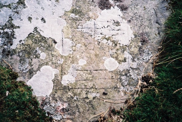
Found it! Quite why I couldn't find it before, I've no idea. The stone is 27 paces at a bearing of 120 deg. from the modern granite pillar inscribed with the number 7 (a waymarker for the Llanfairfechan Upland Walk). The markings can be clearly seen along one edge and on the surface of the stone. Somehow, perhaps because of the short lengths of the markings, I find the antiquity of this stone less convincing than that of the other arrow stones in the vicinity.
The stone marked with concentric squares is another 12 paces downhill at a bearing of 20 deg. from the arrow stone. It lies in a direct line with the signpost at the path junction and the granite pillar
|
    
|
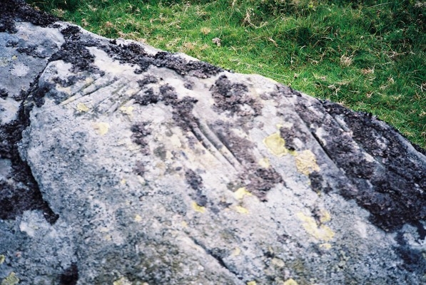
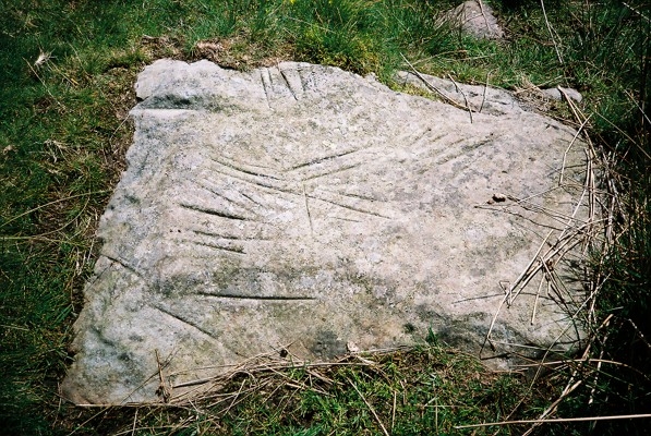
Having spent a fruitless hour looking in the area 200 yards to the east of the sheep pen as described by Bezant Lowe, I gave up and walked away disconsolately. Then lo and behold about 150 yards away I suddenly walked over exactly what I had been looking for all that time. I'm sure I only noticed it because I was grumpily walking along staring at my feet!
It turns out to be about 150 yards SE of the sheep pen right at the NE side of the Afon Ddu. It is 3 yards to the south of a granite pillar with the number 5 inscribed on it, which I have since discovered is a waymarker for the Llanfairfechan Upland Walk marked out by Conwy council.
The markings on the stone are beautifully clear.
|

|
"Some Arrow Stones and Other Incised Stones in North Carnarvonshire and North Denbighshire" by W. Bezant Lowe in Archaeologia Cambrensis 1924 pp. 340 - 362 gives the following description:
"This stone is situated on Nant-y-Cytiau, about 200 yards east of the sheep pens on the way to the Pass of the Two Stones, and close to the Afon Ddu; the sheep pens are about 300 yards east of the wall that runs across the moor to the Afon Ddu. The stone is not very fine grained and is partially covered with turf. All the marks are very distinct, one being ¼ in.wide and 5/16 in. deep. The marks are in groups and vary in length from 4 in. to 10 in. In the centre of the stone is one mark which cuts two others at right angles. The length of the stone (which runs from east to west) is about 2 ft., being 2 ft. broad at the eastern end and 16 in. at the western. There are at least 29 marks."
There is a funny pattern of walls on the OS map at SH 7093 7258 which on the 1891 OS map is marked as a sheep fold and which is just over 300 yards east of a wall that runs north to Afon Ddu. This is less than 1 Km from the standing stones at Bwlch y Ddeufaen and so it seems to fit in with Bezant Lowe's sheep pens. The arrow stone should therefore be another 200 yards further east at ca. SH 7111 7258.
The Gwynedd Archaeological Trust have sent me the information that the Regional Historic Environment Record has an arrow stone recorded at SH 7101 7249 and that there is also reference to the site in the 1956 RCAHMW Inventory of Ancient Monuments in Caernarfonshire Vol 1:East p.127 but that the RCAHMW officers state that the stone could not be located. Perhaps they were looking in the wrong place or perhaps the stone is now totally covered with turf? Who knows? Either way, I hope I can find the time one day to have a good search in the area but would be delighted to hear from anyone who gets there before me!
|

|

|
The grid reference for this site seems a bit inaccurate. I found the 2 smaller stones, each 45 - 50 cm high and 3 paces apart, at GPS reading SK 28255 71378 with the larger stone, 115 cm high, 100 paces away at SK 28225 71454.
There are lots of stones in this area and it is tempting to believe that many others have also been erected. When standing at the larger stone another possible alignment suggests itself looking east to a stone 45 paces away at SK 28265 71450 and a third stone another 20 paces further at SK 28281 71446. The former is leaning over a bit with its top 75 cm from the ground and the latter is 60 cm high.
|
Three lovely stones in a really remote location - it must have been great to rediscover them!
GPS reading SK 28250 70868. The best directions I can suggest are to start at the wall junction at SK 2783 7072 and walk in a straight line towards the very obvious mast on Puddingpie Hill - in dry conditions in February it took me 500 paces until the stones suddenly appeared in a grassy/reedy area just beyond a small patch of heather.
|
|
When I visited in February I thought I could make out a level platform about 6 paces across with 6 very low stones visible on the rim. The area is covered by a mixture of grass and heather and the whole thing is very unconvincing!
|
|
I found what appears to be a ring of rubble under the heather at SK 28527 67706 on my GPS. I think Stubob's photo and description of a much more obvious site refer to what John Barnatt (1990) calls Beeley Moor South (Beeley Moor South 1).
|
|
Yes, sorting out the ringcairns here is a very confusing business. I found a site clearly matching the diagram and description of Beeley Moor South (Beeley Moor South 1) in John Barnatt's 1990 "The Henges, Stone Circles and Ringcairns of the Peak District" at SK 28537 67694 on my GPS. I think Stubob's photo and fieldnotes refer to Beeley North (South 2).
|
This stone is listed by the Gwynedd Archaeological Trust as of "unknown period"
"Some Arrow Stones and Other Incised Stones in North Carnarvonshire and North Denbighshire" by W. Bezant Lowe in Archaeologia Cambrensis 1924 pp. 340 - 362 gives the following description:
"An immense boulder of fine-grained rock, situated on the SE slope of Moel Faban, about 3 yards to the NW of a stream that flows down the valley between Gyrn and Drosgl, and about 12 yards to the NW of the path from Tanyfoel in the direction of Gyrn. The stone roughly measures 12 ft. by 12 ft. and 10 ft. high, but 3 large fragments have evidently been split off by frost. The markings occur in different places on the main block of stone.
(a) The most interesting group are those on the highest point of the stone; they are in a cup-shaped oval cavity which measures 6½ in. by 9 in. The markings, 23 in number, radiate from the centre of the cavity, and seem to be in 4 groups, each group having one deep and broad mark, about 6 in. long; the remainder are from 2½ in. to 3 in. long.
(b) On the NW face of the stone are two groups. In one group are 10 marks having lengths from 1½ to 6 in. They are all well marked and the deepest is 3/16 in. deep. To the right of this group are 5 fine marks measuring from 3½ to 5 in. About 15 in. above the last set is a narrow flat surface and on this are 11 marks, with one cutting across them: the middle one is ¼ in. deep, and the length of these marks is about 3 in."
|
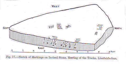
"Some Arrow Stones and Other Incised Stones in North Carnarvonshire and North Denbighshire" by W. Bezant Lowe in Archaeologia Cambrensis 1924 pp. 340 - 362 gives the following description:
"Situated 100 yards NNE of the signpost, and the direction of its greatest length is NNE by SSW. Its length is 9 ft. 6 in. and its breadth 3 ft. 2 in. The edge is quite straight and the surface of this side slopes at an angle of 20 degrees from the vertical." He describes 10 "more or less vertical marks" on "the upper edge of the sloping surface i.e. along the edge" and 29 markings in 7 groups on the top flat surface.
The nearby stone incised with concentric squares is described as "about 110 yards NE of the signpost, flat and level with the surface of the ground and partly covered with turf and moss. It is an irregular square, the sides measuring roughly 3 ft. 8 in., 2 ft. 6 in., 2 ft. and 2 ft. 6 in. respectively."
The signpost is said to stand at the meeting of 4 tracks, which I presume is at SH 6932 7223.
|
I got to the circle from Loadpot Hill to the south - it's no easier to find from that direction! The OS map shows it at about the position listed on the scheduling notice on MAGIC i.e. NY4571 1908 but I agree with fitzcoraldo's GPS data i.e. about 150 yards to the NNW. This might not sound much but it could make all the difference tryng to find these recumbent stones in the tussocky grass.
The scheduling notice describes it as a slightly oval arrangement of approximately 81 fallen stones with an external diameter of 20m by 17m. Taking these figures and fitzcoraldo's estimate that the stones define 60% of the circle leaves only about 45cm of the circle for each stone. Therefore if they were all originally standing, they must have been touching or overlapping.
The whole place felt pretty weird to me - a strange jumble of stones in what could have once been a circular arrangement in a pretty dull place. Why did they bother?
|
 
|
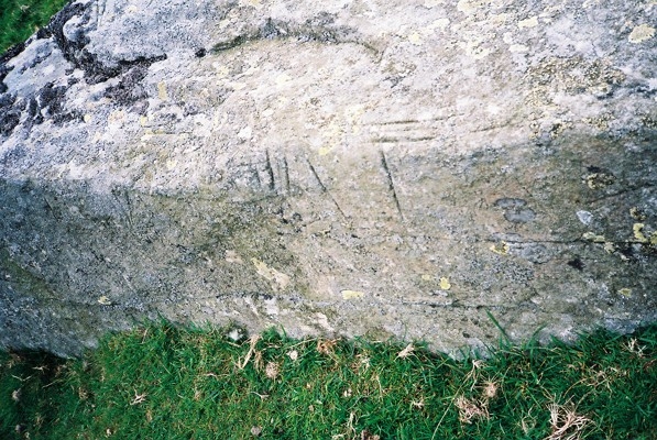
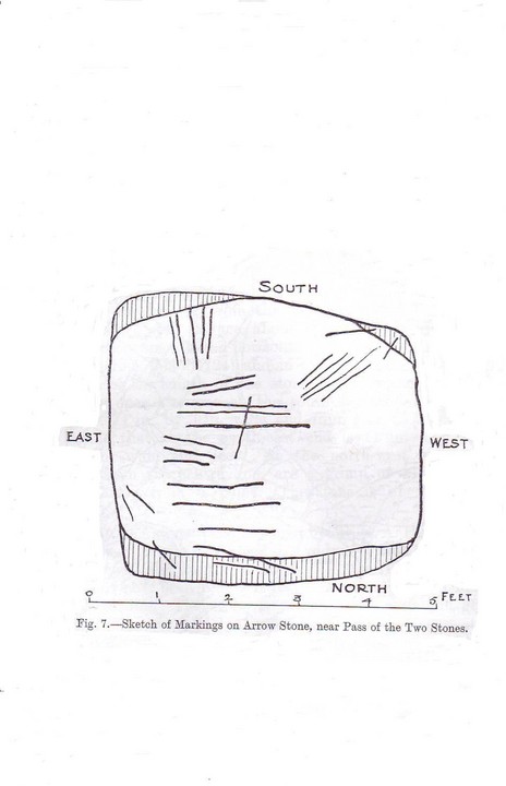
"Cerrig Saethau (Arrow Stones) near Llanfairfechan" by W. Bezant Lowe in Proceedings of the Llandudno and District Field Club Vol. VII 1912-13 pp. 61-65 gives the following description:
"The extreme length of the stone (NE to SW) is 8 feet 2 inches; its width, at the centre, 2 feet 10 inches; it is 3 feet 2 inches wide at a distance of 2 feet from the NE end. A large portion of the surface is perfectly smooth and horizontal, the length of this part being 6 feet 8 inches. The broader end has a downward slope of about 2 feet, and this diminishes to 10 inches on the NE side.
The grooves are very numerous (about 124 in number), and in the centre (in the directions of the length of the stone) are two exceptionally large ones, the one at the SW end measuring 2 feet 11 inches , 1 inch wide, and 1/8 inch to 1/2 inch deep, while that at the NE end is 11 inches long, and 3/16 inch wide and deep. On the NW side, not far from the central part, are a group of 11 grooves, radiating from a point. The stone is of a very fine grain.
When discovered, a few years ago, by Mr Richard Williams, of Hengae, this stone was almost covered by turf."
|
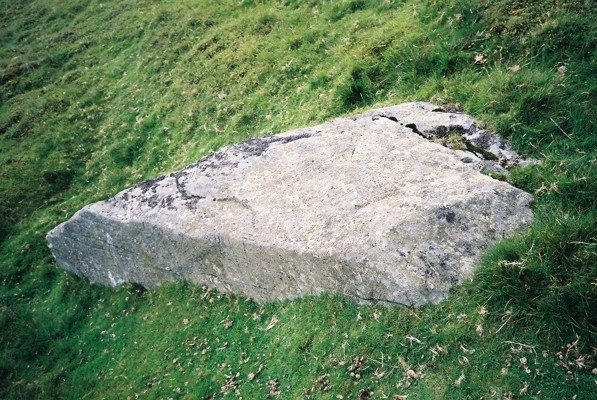
"Cerrig Saethau (Arrow Stones) near Llanfairfechan" by W. Bezant Lowe in Proceedings of the Llandudno and District Field Club Vol. VII 1912-13 pp. 61-65 gives the following description:
"The stone measures roughly 4 feet by 5 feet, but it is broken into two pieces. The surface is flat, and the stone is rounded at the edges. The grooves, which vary from 3 inches to 10 inches in length, correspond with the size of an arrow head, the width varying from 3/16 inch to 1/4 inch, and the depth being 3/8 inch. The markings occur in groups."
|
"Cerrig Saethau (Arrow Stones) near Llanfairfechan" by W. Bezant Lowe in Proceedings of the Llandudno and District Field Club Vol. VII 1912-13 pp. 61-65 gives the following description:
"This is of very fine grain, of irregular outline, and measures 8 feet 6 inches long by 3 feet 6 inches wide; the direction of its length is NW to SE. A small part of the surface, measuring 12 inches by 8 inches, and situated 8 inches from the SW side, and 3 feet from the SE end, has been smoothed, and on this are most of the grooves, but a few may be seen near the NE end of the stone. The marks vary from 7 inches to 4 1/4 inches in length and from 1/4 inch to 1/8 inch in width; they are 3/16 inch deep."
|
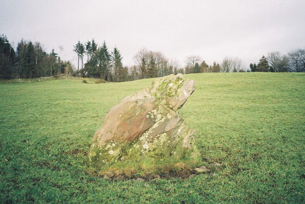
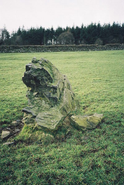
What a briliant stone! - a dead ringer for a squatting toad when seen from the side. It's 1.2m high, 1.1m wide, 0.5m thick and has small packing stones at the base. It lies about 30 yards to the east of the Cistercian Way in an open field, a 5 minute walk from the minor road at SD363776.
The National Monument Record describes it as possibly the remains of a circle of stones such as a walled enclosure. This is based on a confusing reference from 1872. There is certainly nothing else visible now.
|
|
The National Monuments Record list a "probable bronze ring cairn (with central cairn) on Gibbet Moor" at SK27894 70557. The NMR report claims it was unrecognised before the RCHME survey 1988-90. It is distinct from the 3 sites in a NW/SE line near SK 27965 70649 which were once interpreted as ringcairns, which Barnatt 1990 interpreted as robbed cairns but which the NMR identifies as Bronze Age house platforms surrounded by field clearance.
|
|
The Ordnance Survey have just replied. They are also confused by the symbol on the map and agree that it is in the wrong place. At the next revision they will put an appropriate symbol at SK 2833 7728. Quite what that symbol will be is anyone's guess - I have counted 8 different symbols for stone circles on the OL24 sheet alone.
|
|
From Barbrook I, find a track a few yards beyond the cairn to the NE and then follow it approx NNW for just over 200 metres.
|
Don't be thrown as I was by the funny symbol (5 dots in a pentagon) which appears just to the right of the words "Stone Circle" on the OS Explorer map. I assumed it was an obscure symbol for a stone circle but in fact the circle is somewhat further south and I haven't got a clue what the symbol really means!
The circle can be found by walking 200m on a bearing of 230 degrees from the path junction. Don't try looking for the reservoir for help - it has been drained and will not be refilled.
|
Frances Lynch in A Guide to Ancient and Historic Wales: Gwynedd gives the following:
"A cairn of large boulders set on the inner edge of a low grass-grown stone bank forms a circle 6.5m in diameter. The centre is hollowed and probably artificially levelled. there has been no excavation here, so one cannot tell what or who was buried, nor whether it was built at exactly the same time as the lower circle. However, the circles' complementary setting in the landscape - one being visible from the south, the other from the north - would suggest that they were designed as a pair. The very large stone on the south side may be an earthfast boulder; the incorporation of a natural feature is quite common in monuments of this kind (see Cefn Caer Euni Circles)."
|
Frances Lynch in A Guide to Ancient and Historic Wales: Gwynedd gives the following:
"It is a ring cairn, similar in design to the upper circle but with taller stones set at regular intervals on the inner edge of its low stone bank. Four of these stones have been missing since the 17th century, so new ones were placed in the original stone-holes when the monument was excavated and restored in 1979. These added stones have been marked with a deep T cut into the back.
The interior has been levelled into the slope and several pits had been dug before it was covered with a thin layer of stones (only surviving in the northern quarter). Some of the pits had been dug close to the inner edge of the bank, others were in the centre of the ring. The pits contained various deposits - charcoal alone, charcoal with scraps of burnt human bone, and burnt bone alone, the product of a 'normal' cremation burial. In one case the scraps of bone had been previously buried near the coast (to judge by the soil around them) and had been reburied up here. Some of the bone and charcoal was in pots typical of the early Bronze Age, some just poured directly into the pits.
This evidence indicates that a variety of activities had taken place within the circle. Some of them are matched at other ring cairns in the region; others - the reburial of bone for instance - were unknown before this excavation, but have since been recorded in south Wales. There was evidence to show that the various pits had been dug at different times, and radiocarbon dates suggest that the circle was in use between 1700 and 1400 BC."
|
|
I was up there this week and must say that it was a real joy. The footpath from the end of the tarmaced road at SK120705 is now clearly signposted and there is no longer any sight and certainly no smell of the former landfill site! The tomb itself was looking majestic and well cared for by the landowner and the national park - lets dream of the same happening elsewhere!!
|
This site is more interesting than Hafod y Garreg but that's not saying much! However there is a clear row of stones on the north-west side that have been set upright and which leads to a cairn to the south-west.
The description in the visit report from RCAHMW is useful: "It comprises approx. 120 small stones set into the turf and aligned generally in rows N.E.-S.W. incompletely covering an area of about 20 M. square. The N.W. most row of stones seems to point towards a mutilated cairn c. 8 M. to the S.W. The stones occur singly and are in every case but one, a boulder 0.6 M. by 0.4 M. and 0.9 M. high, of a generally uniform size. Distances between the stones vary between 0.5 M. and 1.8 M. A clear pattern of regularity is deiscernible although the pattern is incomplete and obscured by turf."
No photos sorry - camera problem!
|
What stones there are lie in the eastern corner of the field, rather further east than shown on the OS 1:25,000 map. Don't try to use the wood to the west of the track to get your bearings - it has been cut down!
The stones are very small and it is very difficult to make out any clear pattern. In fact if I hadn't got copies of the visit reports from the RCAHMW I would have dismissed them as just stones in the ground!!
It was raining, there was a bull in the field and next morning the back came off my camera ruining the mediocre photos I had taken. All in all a visit to forget and I have still got no idea what the rows are all about.
|
The Coflein description sounds interesting:
"Remains of a cairn defined by a circular ring or kerb of upright edge stones and a central burial cist lined by stone slabs. The cairn is accompanied by two simple round barrows, possibly satellite cairns, both 3m in diameter and 0.3m high."
Unfortunately I couldn't identify anything amidst the mass of stones that lie around!
|
The description in Coflein reads:
"Two cairns set in close proximity on the slope of the Cefn Penagored ridge. Both cairns are about 6m in diameter but are of different forms. The upper cairn has a clearly defined structure marked by a prominent ring of large stones, some over a metre in length. The lower cairn is dedined by an earth and stone bank which includes a large quantity of white quartz. Ther is a small stone lined cist at its centre."
I couldn't find anything in the thick gorse!
|
Immediately to the north-east of the path by the footpath sign. GPS reading SJ 0469 3346. Three very low banks with lots of stones are visible.
Coflein gives the following description: "Three eccentrically concentric stony rings, each c.2.0m thick, 20m overall diameter, the innermost circle, c.6.0m overall diameter. Part of what is designated the 'Cwm Tywyll ritual complex'"
There is also a round cairn of 6m diameter immediately on the other side of the path. GPS reading SJ 0466 3344.
Both are on a plateau with superb 360 degree views.
|
|
On open sloping ground 40m to the south of Nant Cwm Tywyll. GPS reading SJ 0475 3353. 75cm high, 35cm wide, 30cm deep. Ideal for sitting on while drinking a cup of coffee but only room for one!
|
|
The stone is 3m to the east of the fence corner. GPS reading SJ 0274 3432. 1.40m high, 0.95m wide, 0.55m deep. It is pointed with a step on the east side. The long axis runs SE-NW. It stands on the edge of a ridge with super views from the north to the west and on to the southeast. I guess it was a route marker up to the Cefn Penagored ridge above.
|
Yr Aran Standing Stone II
The Clwyd Powys Archaeological Trust lists this stone as bronze age with map reference SJ 0358 3194. Two other standing stones nearby which they designate as stones III and IV are listed as post-medieval with map references SJ 0350 3202 and SJ 0335 3200 respectively.
|
These 5 stones all lie on the ridge which leads from Cwm Pennant up to Pen-y-Garnedd at SJ 0410 3092 where there is a round barrow (cairn). All are listed by the Clwyd Powys Archaeological Trust as being from the bronze age. It seems likely that they marked the route up to Pen-y-Garnedd which would also be a good route to get over to the stone circle and row at Rhos y Beddau in the Disgynfa valley.
Some of the stones are pretty small but they are all quite slim and have been set upright in the earth. I can't see any logic to the directions in which they have been set. The ground is grassy with almost no other exposed stones visible.
|
|
This stone looks like a beached whale. It is clearly visible in the middle of the field on gently sloping ground in a slight hollow. GPS reading SJ 0332 3329. 1m high, 1.5m wide, 0.65m deep with long axis 80-260 degrees
|
|
Yr Aran Standing Stone I - leaning over in a hollow on sloping ground. GPS reading SJ 0355 3314. 45cm wide, 15cm deep, at least 60cm long but leaning over so that the tip is only 35cm above the ground. The long axis runs 120-300 degrees
|

Yr Aran Marker Stone II
In a hollow to the west side of the ridge on sloping ground. GPS reading SJ 0357 3312. 55cm high, 50cm wide, 13cm deep with long axis running N-S
|
Yr Aran Marker Stone I
A tiny stone on the east side of the ridge, well clear of the bracken. GPS reading SJ 0372 3278. 40cm wide, 12 cm deep, at least 40cm tall of which 20cm is visible. The long axis runs 120-300 degrees.
|
Ok, so what are they?
The Gwynedd Archaeological Trust lists the 3 arrow stones as being prehistoric but Coflein classifies them as of unknown period.
H.S. (Bill) Chapman has sent me a copy of his interesting article in 3rd Stone Oct-Dec 1998 entitled "'Arrow stones' and related phenomena: North Wales examples of prehistoric art". It lists 15 possible sites and draws parallels with markings found elsewhere.
The term arrow stone comes from the idea that the grooves were caused by the sharpening of arrows. This seems implausible but quite what they symbolise, if anything, is unclear. I hope to post some further ideas in the near future.
|
This stone is just 3 paces south of the track and so has suffered the indignity of lots of modern inials being carved into its surface. GPS reading SH 6924 7100.
There are incisions up to 20cm long, 3mm wide and 2mm deep. Lichen on the east side may be hiding more.
The Gwynedd Archaeological Trust list the stone as coming from the medieval period but to me it seems to have similar character to the Llanfairfechan Arrow Stones just across the county boundary in Conwy which are classified as prehistoric.
|
The stone is immediately to the south of the track. GPS reading SH 6926 7223.
It is 1.75m long, 0.55m wide, 0.55m deep and is leaning over at a marked angle. It is not listed by either Coflein or the Gwynedd Archaeological Trust - I will contact the latter to ask why not.
|
This took a bit of finding in rather boggy moorland but was well worth the effort. It is 35 paces south of the wall from the last tree (a hawthorn), which in turn is 35 paces down from the gate in the wall running along the north side of the field. GPS reading SH 6957 7315.
The stone is flat and almost level with the ground, 2.25m long E-W and 0.9m wide N-S. In parts the surface has an odd, almost cement-like, textrure - perhaps it has been smoothed. The incisions are up to 20cm long and 8mm deep.
Coflein describes it as "an arrow stone located on open moorland with more than 100 incisions on its surface."
|
Showing 1-50 of 130 posts. Most recent first | Next 50
Folk singer, sword dancer, hill walker, Welsh Rugby fan, husband and father. Retired (early!) to stop work getting in the way of interesting things in life. I'm intrigued by stones in wild, remote areas which give clues to what enriched the lives of people living there millenia ago - I'm less interested in what was done to them when they died.
I've been living in Germany since 2007 and so my UK posts have almost dried up!
|
|