A cloven standing-stone; 2.2m tall*, or a very anomalous stone pair, acting as apt familiar to the nearby 'Cross of the Evil Spirit'.
Similarities in texture, colour and the apparently compatible inner sides of the two slabs indicate that they are two parts of the same stone. The confusion is caused by the steep angle with which they rise from their clearly separated ground-level positions.
*Archaeological Inventory of Cork, 1992; No.468, 64
Permission to visit this site may be obtained from the house on the opposite side of the road that runs southeast from the field.
|
An impressively varied, but perhaps noncontemporaneous, complex, consisting of a tall stone pair and a ringfort with adjacent standing-stone*. A field boundary-wall now splits the former group, N-S, from the latter.
*Archaeological Inventory of Cork, 1992; No.188, 41; No.382, 57; No.1577, 178.
Access may be gained and permission to visit obtained, at the farmhouse at the beginning of the trackway to the east.
|
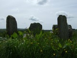
A probable anomalous stone pair, recorded as two separate standing-stones in the Inventory. The mutation is in the placement of the NE stone; 2m long*, which appears to be set in a deliberately recumbent position. The stone to the SW; 1.3m tall*, stands in line with the long axis of the former and is L-shaped in cross-section. Another standing-stone, beyond the field boundary and south of the axis of the pair, is not listed in the Inventory and may be modern.
Views are extensive to the S, E and N but are blocked to the W by a short rise towards the summit of a low hill, a similar blind to the other Argideen valley pairs at Knockawaddra E and Sarue and the row at Knockatlowig.
*Archaeological Inventory of Cork, 1992; No.276, 49; No.513, 67.
Access is through the farmyard, by the road to the east of the site and permission to visit may be obtained at the adjacent farmhouse.
|
The following is a list of town-land names that I have translated from the map (in 'images') above. In order to keep clutter on the (small-scale) picture to a minimum, I have only inscribed those town-lands that contain megalithic remains. For this same reason I have omitted two standing stones from the sketches in Coolnaconarty. The topographical names appear in bold print on the map and are listed in the second section.
I
Reavouler; Baldir's Plain; Standing Stone
Killinga; Church of the (Finger) Nail; Standing Stone (Possible Stone Pair)
Curraghnaloughra; Moor of the Rushes; Standing Stone
Garryglass; Green Moor; Stone Circle
Tullig; Gentle Hill; Standing Stone
Reanascreena; Plain of the Shrine; Stone Circle
Milleenagun; Hillock of the Hounds; Standing Stone, Wedge Tomb
Lettergorman; Gorman's Hillside; Standing Stone, Four-Poster, Stone Circle
Knockawaddra; Hill of the Dog; Stone Pair, Stone Row
Maulatanvally; Hillock of the Old Town; Anomalous Stone Group, Stone Circle
Glanbrack; Speckled Glen; Anomalous Stone Pair, Stone Circle
Carrigagrenane; Rock of the Sun; Two Stone Circles
Sarue; (In this case; the Blind) Stream; Stone Pair
Inchinattin; Meadow of the Furze; Standing Stone
Coolnaconarty; Corner of the Hounds; Five Standing Stones (inc. Possible Anomalous Stone Pair)
Knocks; Hills; Standing Stone (Possible Stone Pair), Stone Pair (Possible Stone Row), Two Stone Circles
Derreen; Oak Grove; Standing Stone
Caherkirky; Fort of the Moors; Standing Stone, Two Boulder Burials
Knockatlowig; Hill of the Host (of People); Stone Row
Ahagilla; Field of the Standing Stones; Stone Circle
Coolcraheen; Crahen's Corner; Standing Stone
The area included is approximately 14km from east to west and 9km north to south; the western Argideen river-valley, the hills around Carrigfadda and "a remarkable concentration of recumbent stone circles, Five-Stone rings and Four Posters."* The relevant name-translations are based on information provided at http://www.logainm.ie, with the exception of the following; Reavouler, Garryglass, Reanascreena, Carrigagrenane, Sarue, Caherkirky, Knockatlowig, and Ahagilla.**
*Burl, "A Guide to the Stone Circles of Britain, Ireland and Brittany", 2005; 227.
**Reavouler; "Mowler's Plain" in logainm.ie. The 'v' sound in the name and the presence of a 'd' in the earliest examples (Revaldir etc.) inclined me instead towards the use of Baldir or Balder, similar to the translation of Carhoovauler in the same resource; "Boulder's Quarter".
Garryglass; "Green Garden" in logainm.ie. Although this is a perfectly valid translation, with precedent elsewhere in the country, the local pronunciation of the name and the type of landscape, have inclined me towards "curry" (marsh/moor), rather than "garry".
Reanascreena; Not translated in logainm.ie; "Ring of the Shrine" in Burl (2005); According to P.W. Joyce "Reidh" is a coarse mountain flat (plain), which makes sense in the context of this town-land's location.
Carrigagrenane; "Rock of the Bower/Arbor" in logainm.ie; "Rock of the House of the Sun" in Burl (2005); Local pronunciation drops the final syllable of the town-land's name and the area is referred to by the older generation, in English, as "Sunny Rock". At the risk of being romantic, I followed this convention.
Sarue; "Overpowering, Profaning" in logainm.ie. According to Joyce "Sruth" is a stream.
Caherkirky; "The Hen's Stone Fort" in logainm.ie. "Corcach" meaning marsh or moor seems more plausible than "Cearc" as a basis for "Kirky", yet the pronunciation of that term, as evidenced in other local names, is not exactly like that found here. Not sure about this one.
Knockatlowig; Not translated in logainm.ie. According to Joyce "Sluagh" is a host or great grouping of people.
Ahagilla; Not translated in logainm.ie. According to Joyce "Achadh" is a field and "Gall" a standing stone, or foreigner.
II
An tAirgidin; Silver River
Carrigfadda; The Long Rock
Loch Atarriff; Lake of the Bull
Glashagleragh; Noisy Stream
Clashatarriff; Furrow of the Bull
Blind Stream
Corran Lake; Lake of the Cairn
Curraghalicky Lake; Lake of the Flagstone Moor
An tSaobhnósach; River of False Custom
http://www.themodernantiquarian.com/forum/?thread=48142&message=600210
http://www.themodernantiquarian.com/forum/?thread=23046&message=615648
|
'They have made themselves an image of a bull-calf, they have prostrated themselves before it, sacrificed to it and said, "These are your gods, O Israel, that brought you up from Egypt."'
Exodus 32, 8.
'Can brazen cymbals clashing, pipes with curving horns, trickery and magic have an effect so great…?'
Ovid, Metamorphoses, Penguin, 1955, trans. Mary M. Innes, Book III; within 518-555.
'When morning came, the men of Ireland saw the Donn Cuailnge coming westward past Cruachan with the mangled remains of Finnbennach hanging from his horns.
He brandished them before him all that day, and at nightfall entered the lake near Cruachan.'
The Táin, translated from the Tain Bó Cuailgne by Thomas Kinsella, Oxford, 2002, 252.
|
"There was an ancient forest which no axe had ever touched, and in the heart of it a cave, overgrown with branches and osiers, forming a low arch with its rocky walls, rich in bubbling springs. Hidden in this cave dwelt the serpent of Mars, a creature with a wonderful golden crest; fire flashed from its eyes, its body was all puffed up with poison, and from its mouth, set with a triple row of teeth, flickered a three-forked tongue."
Cadmus, son of King Agenor of Sidon, struggled with and defeated the monster...
"Then Pallas, the hero's patroness, suddenly appeared, gliding down through the upper air. She told him to plough up the earth, and to sow the serpent's teeth, as seeds from which his people would spring."
from 'The Founding of Thebes'; Ovid, Metamorphoses, Book III.
|
The term used for this class of monument; 'Boulder-Burial', is not exactly a misnomer although no human remains were found by Dr. William O'Brien in his excavation of three sites at Ballycommane and Cooradarrigan (dated from charcoal fragments to 1426-1266 BC). A token amount of cremated bone was found in the Bohonagh excavation and the acidic soil conditions may have been sufficient to destroy any similar evidence at the former three sites. I tend to think, though, that there is a sort of graceful beauty and fit to Somerville's suggestion, borrowed from the North-West of Ireland, of 'Clochtogle/Clach Tógáil' or 'Lifted Stone'.
Fahy, E., 'A Stone Circle, Hut and Dolmen at Bohonagh, Co. Cork', JCHAS 66, 1961; 94
O'Brien, W., 'Boulder-Burials: A Later Bronze Age Megalith Tradition in South-West Ireland', JCHAS 97, 1992; 11-35
Somerville, B.T., 'Prehistorics', JCHAS 33, 1928; 66
|
http://antiquity.ac.uk/ProjGall/wilson/index.html
Scroll down here to get Michael Wilson's astronomical hypothesis, as it pertains to Caherkirky. He would have walked a short way north from the monument to get this clear horizon view, as far as I can make out. My picture was taken on the other side of the fence, to the south.
You can make up your own mind about the conclusions.
|
The quartz circle stone, despite its fit with late Bronze Age ritual colour schemes, is placed on an empty socket position and is not an original feature. Two out of the three support blocks under the large boulder burial are quartz however, as was a large support stone at the base of the pillar to the north of the portals.
For those who like to let their imaginations run, here's a roughly contemporary account of a similiar construction from Exodus 24, 4-8:
Moses wrote down all the words of the Lord. He rose early in the morning and built an altar at the foot of the mountain, and put up twelve sacred pillars, one for each of the twelve tribes of Israel. He then sent the young men of Israel and they sacrificed bulls to the Lord as whole-offerings and shared-offerings. Moses took half the blood and put it in basins and the other half he flung against the altar. Then he took the book of the covenant and read it aloud for all the people to hear. They said, 'We will obey, and do all that the Lord has said.' Moses then took the blood and flung it over the people, saying, 'This is the blood of the covenant which the Lord has made with you on the terms of this book.'
|
A significant reassessment by Helen Roche of the construction date for the Great Circle: 'The dating of the Embanked Stone Circle at Grange, Co. Limerick' in Roche, Grogan, Bradley, Coles and Raftery (eds.): 'From Megaliths to Metal - Essays in honour of George Eogan', 2004, 109-116.
The most recent pottery-type, found at a position which would have predated the monument - in this case beneath the bank on the old ground surface - was 'Class II' ware. This type, in the light of extensive comparitive studies with securely dated material over the years, is now judged to be a Late Bronze Age coarse ware. Therefore the circle, officially designated to have been constructed in the Neolithic, is actually a Late Bronze Age site, of a similiar age to the axial stone circles that I felt had a comparable skeletal stucture (see fieldnotes above).
|
Dating evidence, dependent on excavation and the retrieval of datable material, is scarce for the Cork-Kerry stone circle complex. Three ranges have however been produced and are as listed below:
Drombeg 1124BC-794BC
Reenascreena 1254BC-844BC
Cashelkeelty 1362BC-794BC
(O'Brien, 'Aspects of Wedge Tomb Chronology' in Shee Twohig and Ronayne (eds.), 'Past Perceptions: The Prehistoric Archaeology of Southwest Ireland', 1993, 70).
An assumed date of about 1000BC for the construction of Lettergorman South would probably be reasonable and Clive Ruggles has calculated the Winter Solstice sunset declination at this time to be -23.8 degrees (Astronomy in Prehistoric Britain and Ireland, 1999, 57).
Unlike the excavation record the archaeoastronomical survey history of the complex is comparatively extensive, if frustratingly incomplete. Somerville made some initial investigation in the early years of the last century, but the first large survey, of 30 circles, was undertaken by John Barber in the early 1970's. He listed Lettergorman (Knockawadra) as -26.111 degrees, some 2.311 degrees, or over 4 diameters, off the solar event, and looked instead to the stars for an alignment ('The Orientation of the Recumbent-Stone Circles of the Southwest of Ireland', JKHAS 6, 26). In fact the only Winter Solstice alignment he confirmed was the well-known one at Drombeg.
At the start of the next decade, however, a correction to his data was published by Patrick and Freeman ('Revised Surveys of Cork-Kerry Stone Circles', Archaeoastronomy, no.5, JHA, xiv, 1983, 51) when their own survey revealed a systematic difference with that of Barber, a discrepancy which they proposed to have been caused by the metal in his theodolite and tripod. Their findings linked Lettergorman (Knockawadra) at -24.3 degrees to Drombeg (-22.68) in a duo demonstrating a midwinter sunset orientation.
This alignment is not widely known, even locally. A historian who lives a few miles away and has visited Knocks North for the Equinox and Drombeg for the Winter Solstice wasn't aware of it when I mentioned it to him recently, but Jack Roberts does seem to have witnessed it ('Exploring West Cork', 1988, 131).
Clive Ruggles was also attracted to this region's monuments, but only surveyed the multiple stone circles, publishing data for 31 sites ('Astronomy in Prehistoric Britain and Ireland', 1999, 217). A combination of the 2 sets of data means about 40% of the complex has now been accurately assessed, with three circles proposed to be in alignment with the Winter Solstice: Drombeg, Lettergorman South and Teergay (near Macroom).
In this respect Ruggles makes a slightly odd statement when he writes of Drombeg:
'Although much-heralded, the solar alignment is not repeated at a single other example of this type of monument'
(Ruggles, Prendergast and Ray (eds.), 'Astronomy, Cosmology and Landscape', 2001, 53)
Granted that he doesn't include five-stone circles in his assessment, he still has Teergay measured at exactly -23.8 degrees in his table of data? I'm sure I'm probably missing something...
|
Taken from the Irish Examiner dated August 21 2007. A front page article by, appropriately, Sean O'Riordan.
"Archaeologists uncover county's 'first capital'
Archaeologists believe that they have discovered what may have been Cork's ancient capital, built 3200 years ago at a time when Rameses III was pharaoh of Egypt.
A team of archaeologists from UCC, led by Professor William O'Brien, have carried out extensive research that sheds new light on what is the largest prehistoric monument in Co. Cork and the oldest dated ringfort in the country.
Their three-year project, funded by the Irish Research Council for Humanities and Social Sciences and the Royal Irish Academy, shows that huge wooden defence walls once surrounded the ringfort at Knockavilla, near Innishannon.
Radiocarbon dating shows that the ringfort was constructed about 1200 BC, confirming it as the oldest known prehistoric ringfort in Ireland and, according to Professor O'Brien, this puts its importance on a par with prehistoric sites such as Dún Aengus on Inishmore and Mooghaun, Co. Clare.
Archaeologists have concluded that several thousand timber posts surrounded the ancient structure, known as the "cathair", which enclosed nearly 20 acres - enough space for today's developers to construct about 300 houses.
It would have taken hundreds, if not thousands, of people to construct it and may have been built in a matter of months.
"The antiquity and immense size of this monument suggests that it was one of the most important prehistoric settlements in the south-west region, and arguably Cork's first capital," said Professor O'Brien.
The outer defence walls had a perimeter of more than one kilometre and were built with wattle fencing. These were erected behind a dug-out ditch defence.
The inner timber defence, built entirely of solid oak, was 800m at its perimeter. Archaeologists discovered evidence that part of the inner palisade fence had been burnt, which Professor O'Brien and his team believe "was a deliberate act of war".
The people who built the ringfort may have been slaughtered. At any rate their kingdom seems to have disintegrated as no efforts were made to repair the fort and it was never inhabited again."
|
According to Somerville (1930) 'Meall an tsean baile' translates as the 'Hillock of the old place'. The former he presumed to refer to the high ground to the west of the circle and the latter to the monument itself.
While this would give a satisfying romantic colouring, it is of course possible that baile could indicate a long past (but not prehistoric) village or small settlement in the area of the hill.
|
"And then we emerged to see the stars again."
Dante Alighieri, Inferno XXXIV, 139.
(Trans. C.H. Sisson, Oxford 1998)
|
|
"Can this be death?" thought Prince Andrew, looking with a quite new, envious glance at the grass, the wormwood and the streamlet of smoke that curled up from the rotating black ball. "I cannot, I do not wish to die. I love life - I love this grass, this earth, this air..." He thought this, and at the same time remembered that people were looking at him.
Leo Tolstoy, 'War and Peace', Book Three, Part II, 36.
|