|
Visited today. Some one has decided to 'improve' the site by placing an upright stone in the centre. Considering the time and effort needed to reach it, its incredibly depressing to find it vandalized.
|
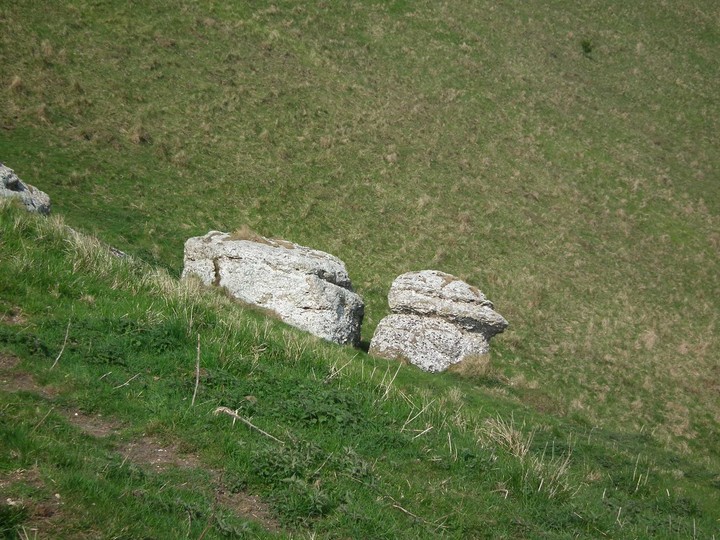
Two large and two smaller stones in the middle of the peatland to the West of Noup and Vinquoy hills. Just off the Eday Heritage walk.
If you didn't know it was the remains of a tomb, you'd think it was possibly a circle.
If you weren't doing the heritage walk and wanted to access from the farm at South Linkataing, the way marks for the walk would still be your best bet for a route onto the moor. Either way, this is pathless moorland with the potential to be quite hard going, and exposed.
As with other chambered tombs in Orkney, the site is below the skyline, and commands fine sea views. Faray, the closest islet has another chambered tomb according to the OS map and I would think they were intervisible.
|
 
|
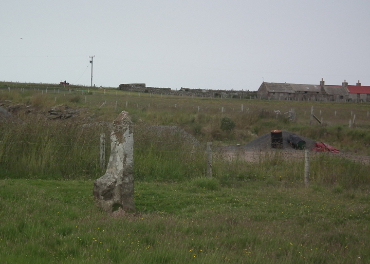
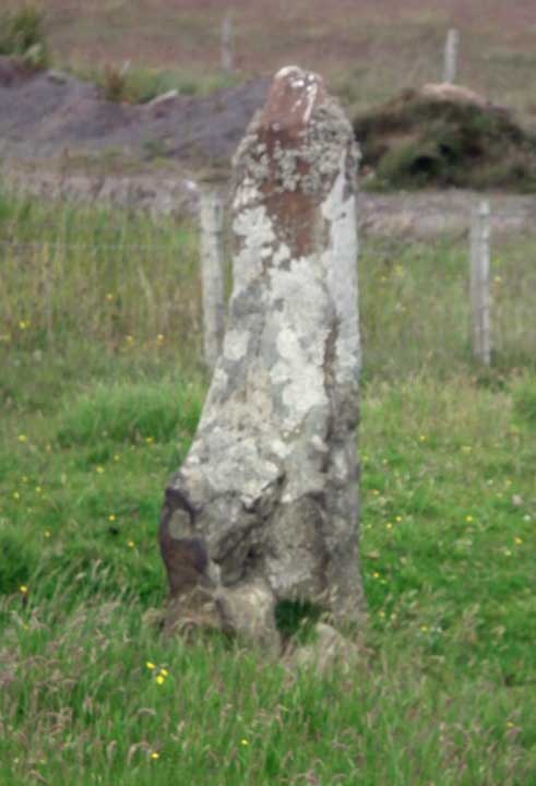
The stone stands rather sadly next to a council road depot full of piles of gravel etc. Although there are signs saying the depot is private, it makes a sensible place to park when closed, rather than the single track road.
The field it stands in is barbed wire fenced so close access would be a pain.
A fairly phallic stone from some angles.
|
The lower passage into the interior is waterlogged, and appears to have been used to dispose of rubbish. Not having a towel, a change of clothes, or knee pads, we just shone our torches down it.
The site is on the Eday Heritage Walk.
|
At present, (July 2013) sections of the tomb are cordoned off with rather ugly safety barriers, and there are notices claiming work to restore and make safe will commence in June 2013(!). While I found the distraction minor, but annoying, others may find that they spoil the experience.
Cost is now £7.00, though I suspect you could get away with just walking up to the sites. However, although before I went I thought the cost seemed steep, you get two useful introductory talks, and the opportunity to handle original artefacts from the excavation, as well as the small museum. Certainly the talk on the burned mound made visiting the site much more interesting.
|
From Norrie Ward 'Yorkshire's Mine' Dent 1969 - Ward is describing 'midsummer's night of 1967'.
"We were lucky; both sunset and sunrise took place in a cloudless sky. The setting sun moved majestically along the ridge two miles away, 'seeming to roll into a flat V-shaped feature of the skyline where Shatton Edge gives way to the line of distant Edale Moor' as I wrote in my notes of the weekend. 'Sunrise was yet more spectacular. Across the mist filled valley the hilltops were aglow with the rich rose-pink of first light as we plodded through the heather to the circle. Across the valley to the north-east was flat topped Higger Tor. ...It was a moment that was over all too quickly..the sun wheeled upward into the sky.
Here was a clear point on the skyline by which to know the time of the summer solstice; here was a place to greet it with surety and confidence. Those of our ancestors who lived on these hills had as certain a method of determining high summer as the men who made Stonehenge. On Eyam Moor they needed no Heel Stone; Higger Tor served them well."
|
The track from the main road is quite rough in places, and the fields you cross can be pretty boggy.
The model of the site on a plinth in front of it is difficult to reconcile with the actual site, possibly because some of the panel is overgrown?
Our visit was made more interesting by helicopter gunships doing live firing on the range nearby!
|
Outrage as Neolithic Monument bulldozed flat
Reports began to circulate in early June concerning damage to one of a series of four remarkable Neolithic monuments in Somerset, southwest England. However, the scale of the damage to the Priddy Circles is only now being fully appreciated.
The four Circles are listed together as a Scheduled Ancient Monument, and as such are under the protection of the State. Somerset County Council confirmed it was working in conjunction with English Heritage to pursue a resolution for this distressing situation, which arose when the landowner, Mr Penny, allegedly used his earth-moving equipment to bulldoze, flatten and reseed the entire southwestern arc of the southern circle.
full story at
http://www.pasthorizonspr.com/index.php/archives/07/2011/neolithic-monument-bulldozed-flat-in-england-provokes-outrage
|
|
There is an entrance fee for the site which gets you a guided tour by very knowledgeable folk in 'period' costume. There's also someone demonstrating Viking era crafts. There are toilets and a small visitor centre/gift shop.
|
Good park up for vans at the end of the road to the island. You can overnight here with no hassle.
Site is about 20 minutes walk from the parking along the fantastic 'tombolo' beach and onto the island, though you are likely to take longer as you get distracted by seals, birds and the overall beauty.
Oddly the section of the chapel where a section of ground has been cut away to show the original floor level has become a depository for 'votive' coins.
|
The site is reasonably well signed from some way off, but the only parking is what looks like a passing place. We went past this thinking that there would be a bigger spot, and its a long way before you can turn round!
Its about 10-15 minute walk to the site from the parking area. Route is well marked with posts and signed. Interpretation boards en route at other landscape features.
Terrain is quite boggy moorland and there could be a midge issue at times.
The site itself is best described as enigmatic. Not clear what it was, and why very unusually for Shetland the sea is not visible.
Many other prehistoric remains in the vicinity.
|
As the photo suggests, the site is best viewed from above on the path to the waterfall. At 'ground level' its a bit hard to interpret.
ADS entry states
A well-defined trackway leads westward from the prehistoric enclosed settlement SD 69 NE 1 up the central ridge of the Cautley valley towards Cautley Spout. It takes the form of a lynchetway, a hollow way and a built-up causeway in various places and is approximately 3.2m wide. Further to the W its course is marked by some small boulders which may have been deliberately placed. This trackway seems to be connected with the settlement and may be contemporary.
|
  
|
The stones themselves are on fenced off land, but you can view them without crossing any fences or disturbing any crops by walking S on the minor road (Centenary Way) from Wharram Percy car park past the junction of footpaths to where the field edge joins the road, then walking back N along the field edge. The field edge moves away from the road, and you get a good view of the stones.
Mythopoetic coincidence - a disused railway tunnel enters the dale just to the N of the stones.
|
For my money the easiest approach is from the point where Sir William Hill Road coming out of Grindleford meets two footpaths and turns into a track at SK2245 7742. Easy parking on the lane. Between the two footpaths is a third track visible on Google Earth though not shown on the OS map. It heads towards the circle and forks - take L fork and then you can pick up track(s)on R to the circle. However, the ease is relative, and I would recommend using GPS.
My interpretation of the site would be that it feels as if its designed for an 'audience' to the S observing activity with the dramatic skyline as a backdrop.
|
|
Easiest approach from Hordron Edge circle is via the shooting track that you took from the A57. If you carry along the contour line from the circle you'll intersect it as it comes up from the valley. It takes you to a bridge over the beck, which is far easier than routes across the moor suggested elsewhere.
|
Visited June 2010.
Worth noting that the owner of the land where you park asks for a £2 donation to the Air Ambulance to be left in the postbox on the gate to the metalled track to the lakes.
Some drainage and surfacing work has been done on the direct path, which should make it easier going. However, as we visited in very dry weather, I can't comment on how bad it would be in the wet. This is a very isolated spot in potentially dangerous terrain, so proper equipment and clothing is a must.
You can follow the metalled track to the lakes then keep going along the higher ground to opposite the site, which reduces both height lost in crossing the valley and the amount of distance taken through bogs. However, the ground is rocky and there are some springs.
|
Visited August 2009. The site was somewhat overgrown and it was difficult to see the position of anything other than the main cist. We walked up from Chelmorton, but you could easily drive quite close to the site from the lane going past Five Wells Farm. A peculiarity of access to the site is that when you follow the line indicated by the (now broken) finger post, you need to go *past* the site maybe 50 yds to a gateway which isn't obvious as you approach, meaning the temptation is to scramble over a collapsed drystone wall - I'm sure the farmer would rather you didn't!
You don't quite get a 360 degree view now, but when the mound was there you would have done from the top.
|
|
According to a leaflet in Kirkinner Church, quoting 'Old Wigtown' by Jack Hunter, the stone is called the Old Bridal Stone, and couples used to use it to make a marriage contract by joining hands through the hole. The C10th cross in the church was similarly used, which raises the possibility that the hole is a later addition to the stone.
|
|
Visited August 2009. The stone was in a cropped field and therefore not accessible.
|
Visited on a Northern Earth Mysteries day out. Our guide warned us that there have been problems with Rottweilers from the adjacent property menacing visitors - physical contact though not bites. On this visit there was barking from a sheepdog on the other side of the fence, but nothing worse. Apparently the structure was originally some 300 ft long (!), but much of the stone has been robbed over the years. The site is somewhat encroached by vegetation, but attempts have been made to cut it back, and apparently the situation is now better than it has been in the past.
It is strongly recommended that you report any issues with dogs and/or vegetation to the local authority if you encounter them here.
|
Visited 6/4/08, and took the Rock Art Tour. This costs six pounds, which some might say was pretty dear for a couple of definite images and a couple of possibles.
Having said that, the moment when you 'see' the reindeer carving reveal itself from under the modern graffiti and natural markings as the guide outlines it with her laser pointer is pretty incredible.
Our guide was very good with the children in the group, some of whom were quite young. There are no restrictions on photographing the art, although you are advised not to use a flash, this is because you get better pictures without then with.
As others have said, the gorge seems to have been transplanted into a very bog-standard midlands landscape from elsewhere. According to our guide there are some other smaller ones nearby some of which also had rock shelters.
Completely non-MA, but a short walk to the E of the site along Robin Hoods Way takes you to the remains of subterranean structures built by the 'Mole' Duke of Portland in the C19th including a chapel and art gallery. Strange to have such an unconscious echo of the ancient past constructed in the industrial era....
|
According to Jennifer Westwood's "Albion' (1986) the chambered cairn at HU362855 is called 'Trowie Knowe - the Troll Mound, though there are no specific legends associated with it.
Sheltland's Trowies, are grotesquely ugly, dress in grey, and can only come out at night. If caught in daylight they turn to the stones they resemble. They share attributes with fairies elsewhere, exchanging their children for human babies, and abducting girls as wives, sometimes leaving a 'stock' in their place. See Haltadans for Trowies and music.
|
|
Group of three cairns associated in legend with the nearby Haltadans stone circle. The cairns are more readily visible than the circle, but still quite hard to distinguish from the geology of the area. As with Haltadans please be aware that the area is a nesting site for birds.
|
|
At the Fetlar Interpretive Centre in Houbie, you can listen to a recording of the tune allegedly learned from the Trowies. The Centre also has a good collection of other folklore and archaeological material.
|
Access is by a fairly obvious track out along the promontory from the end of the minor road signposted 'Scatness'. Its about a mile to the fort, part of which is along a narrow rocky strip with chain hand rails. It was a fine day when I visited, but this would be very dangerous in rough weather. Please avoid the pool to the left as you start off if visiting in the nesting season, as it is home to a tern colony.
The Historic Scotland guidebook for Shetland suggests that the fort is contemporary with the brochs, but represents the efforts of a community with less resources than those who could 'afford' brochs.
The fort itself consists of a double ditch and bank, once stonefaced, which cuts off the headland. There's a stonelined passage through this and into a 'blockhouse' with two cells and the remains of a third.
Please note that the first assemblage of stones you see is the misguided result of 'tidying' the site.
|
|
Only seen from roadside as on way to ferry and there are no ready parking spots on the single track road, but this stone is one of the most impressive I've seen. It really does look like the figure of a woman.
|
|
Would recommend taking advantage of the audio guide which comes included in the admission fee, and does a very good job of explaining the various layers of settlement here. Takes about 30 mins for the basic package, though there are optional extras which would take it over an hour.
|
|
Visited June 2007. Could not readily identify the site at the grid ref given by the O.S. Best reached by driving to the airstrip or the waterworks along a rough track, and then striking out in the direction of the summit in front of you. Please be aware that the area is a nesting site for many birds - including skuas! RSPB ask that you do not approach the lochside as this will disturb rare species.
|
|
In the summer months you can visit Mousa at night, and not only experience this site in the atmospheric 'summer dim', but also see the amazing sight of the Storm Petrels who nest there flitting back to their nests after a day out at sea. Highly recommended.
|
|
Visited 16/1/05 - the carving was partially obscured by soil which had crept over the rock. Cleared the worst off by hand, but it is still difficult to see the image.
|
Ubik hasn't added a profile
|
|