A week in Chatton
You'd be forgiven for thinking that a week's holiday in the village of Chatton, at the heart of the Till valley, surrounded by one of the densest concentrations of rock art in Britain, would offer quazillions of opportunities for the perusal of prehistoric petroglyphic peckings. However, in our case, this was not to be, as the constraints of family duties, combined with an inordinate amount of coursework marking, proved to put the kaibosh on trips to most of the sites Mrs Hob and I had hoped to visit.
However, that's not to say we didn't get to see any ancient stuff. There's just so much of it about in the area, that it's almost impossible not to visit at least one ancient site. This is so much the case, that were this to be a blog describing how many sites can be visited whist spending a week in Chatton, it would read like one of Stan Beckensall's pamphlets. Rather, this is a description of how it is possible to square the circle, and have a family holiday, relatively free from dragging one's kids around to see loads of boring old rocks, yet still manage to take in a fair few quality sites, all within walking distance of the village.
Our Sunday consisted of a walk over to Ros Castle, with Mrs H carrying the baby, my Brother pushing my niece and me pushing our eldest daughter B. It's only about 10mins by car, but seemed at least a couple of hours on foot, pushing buggies. To add to the exercise, B's 3-wheeler caught a flattie about half way there, and then the final ascent from the road to the hillfort on the summit proved impossible for the otherwise redoubtable 3-wheeler, necessitating the carrying of both the littlest bairns. It didn't look as if B would be able to make it, as she's too heavy to carry far, but she was determined to make it to the top, as she wanted to tell her Grandma that she'd been to the top (It's Grandma's favourite hill). So, to my immense pride, B slowly, but determinedly, walked to make it to the top, supported on the easier bits, and carried up the dodgier sections of the loose sandy path. It took a while, but she got there, and agreed that the view was worth the effort. Can you tell I'm chuffed? I do hope so, in which case I can stop waffling on about all this family orientated stuff and get on with the bits about prehistoric remains.
As well as the rock art on the hill, Ros Castle (as the name suggests) also is the site of a prehistoric fort. The hillfort earthworks are difficult to discern, not helped by being sliced in two by a boundary wall, with a lot of heather on each side. The road runs quite close, and whilst there are a couple of steep patches, it's probably worth a detour this way for anyone heading from the Cheviots to the A1. The ground underfoot is loose sandy soil with rocky protuberances, not suitable for wheeled contrivances, and looks like it would need extra care in the wet.
The view is excellent, with the most of Bewick Moor stretching to the south, I think it's just possible to make out Old Bewick Hillfort. The vista is edged on the south east by Hepburn crags, with it's cupmarked cairns, cists, and a small hillfort. To the east, the coast is easily visible, and Bamburgh castle stands out like a sore thumb. To my minor chagrin, the long cairn at Ox eye isn't visible, though it may well have been if the trees weren't there. To the north, the lost carvings of Amerside Law also hide behind conifererous screening, with the Lammermuirs clearly visible on the horizon, I'd think it would be possible to see as far as Edin's Hall broch. To the west is the Cheviot Massif, an omnipresent silhouette, best viewed from the smaller hills to the east, such as Ros Castle.
Monday's visit to Chillingham Castle held very little prehistory. I was a bit saddened to see the poor presentation of the Berthele Collection, four goodly sized display cases containing finds containing the fruits of many years of patient fieldwalking by Fritz Berthele. There are some great bits and bobs in there, including a broken Langdale axe found at Chatton, oodles of nice flints, ceramics and a couple of enigmatic cup-like things.

But the whole collection looked as if it had been knocked about a bit, so everything was very jumbled up and impossible to tell what was from where. Bad show.
We also managed to miss the cup marked stone, which apparently requires getting in touch with the Castle staff beforehand and arranging to see it.
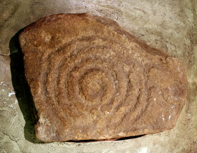
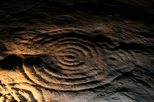
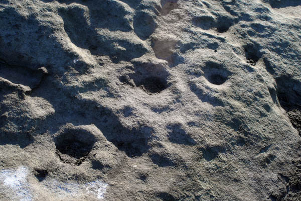
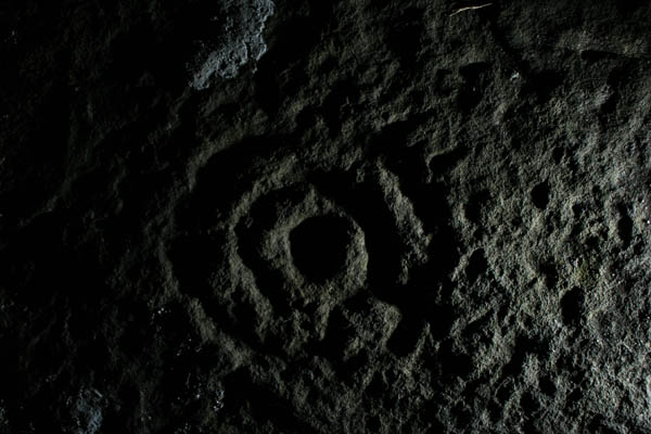
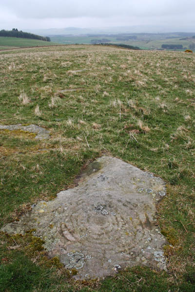
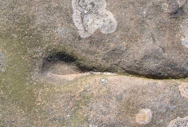
Monday night, having been mildly perplexed at not visiting any panels, I decided to go visit an old friend. This necessitated waiting until after the bairns had gone to kip, eventually meaning I didn't get out until it was dark. I was quite happy with this, as it meant getting the chance to try out the big lamp on the lovely outcrop on Chatton Park Hill. I was a bit worried that it would be awkward to find them in the dark, but happily managed to walk straight to them. The wind was a bit of a problem, as it blew the tripod over, but it didn't stop a few decent images being captured, leaving time to sit and ponder the chances of being mistaken for a poacher, what with all the lamp waving. Could have been partly psychological thing, as it was nightime, but the carvings took on a distinctly 'lunar surface' appearance.
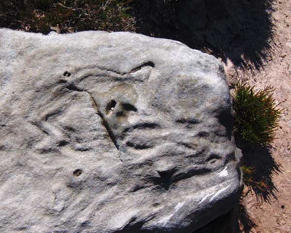
Tuesday involved a trip to see another medieval pile, the still inhabited, Harry Potterised castle at Alnwick. Here, the Postern Tower holds a tidier display of Northumbrian prehistory than that seen at Chillingham, with many interesting bits, such as the Langdale axe shown in this photo.

I couldn't find anything that linked the reference numbers to where the finds came from, but the little tags next to each artefact indicates that someone somewhere is keeping track of them. At this point, I hit my maximum geek level, and didn't pursue matters further by trying to find out what came from where.
On the definite plus side, the Tower also contains three nice examples of portable rock art:
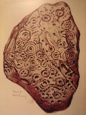
Two imaginatively named cist covers from Beanley Moor

Beanley portable a
and

Beanley portable b
And a nice wee portable found in at wall near the Warrior Stone
Ingoe Wall
Newcastle University's Beckensall archive has a couple of images showing Beanley portable a, as drawn by Mr Collingwood Bruce (here) and as drawn by Stan Beckensall (here).
Wednesday involved another castle, this time over the border, to Floors, involving a fleeting glance of The King's stone and the chance to have a look at High Chesters, an eroded panel of rock art that I've been wanting to check out since it was re-uncovered a couple of years ago. Didn't have much time to ponder though, which was a shame as it's in a heck of a good spot to play the intervisibility game.
Visible from the road leading to Doddington, this bit of carved outcrop has been pretty heavily weathered, it's in a very exposed location. But this means the view over the Millfield plain is excellent, in the olden days, this would have overlooked a henge or three, as there's shedloads of the on the plain. The view also gives a nice profile of the Cheviot and her pals, whilst maintaining a visual link with the other rock art sites on Doddington Moor.
It's currently used as a soapbox by sheep who want to bleat at the passing traffic, and for target practise by the local avian community (Maybe they're actually aiming at the proseletising sheep?)
Once again, the carvings were located sans GPS. (I should damn well think so too…) We did wander in circles for a couple of minutes, having tussled with a scary gorsebush, but the little cairns help immensely. We resisted the temptation to try and set up a tripod under the gorsebush for panel 5, and copped out of trying the same on the uneven surface under the trees at panel 6. These are left for the next nocturnal visit. Besides which, the waving of the lamp seemed to attracted attention from the direction of Clavering, where someone had started waving a lamp back. Not wanting to either:(a) Get mistaken for poachers and end up being shot at, or (b) Disrupt a clandestine attempt to signal to flying saucers. So we skulked off back to Chatton, nonchalantly whistling the tune from 'Rhinocratic Oaths' by the Bonzo's.
Having seen two carvings on Wednesday, my rock art fixation remained sated right through until Thursday night, when following a day with nothing more prehistoric than the dusty pages of an old tome in Barter Books in Alnwick, It was time to drag tripod and lamp up to Doddington Moor to see what it looks like at after dark.
Thing is, I can't really say what it looks like after dark, as the fog was a bit thick, so I only saw the bits within lamplight of where I was. The general impression was one of big black inky nothingness, with a vague orange glow from the direction of Wooler. To err on the side of caution, we turned on the GPS, but (an honour impels me to stress the point) only to trace our tracks in case we got lost in the fog. We didn't have the co-ordinates of any of the panels entered into the device, so we had to locate the carvings Jedi fashion, by using The Force. This conceit being helped along nicely by the effect of a 500,000 candlepower beam lancing through the fog (Whhhaummmm, Nyowm-Tisch! Etc..). Brother Slabdragger only had a hand torch, but nevertheless, he valiantly avoided succumbing to lightsabre-envy. Ahem.
Anyway, we found the main panel easy enough (A first for me…) but discovered that the usual tripod and bulb setting technique was useless due to the moisture in the air. Long exposures and water droplets make for crap photos. The side fill flash sort of worked, but it's tricky to get the timing right when you're using shutter speeds of less than a second. Managed to get a couple of OK images though.
Gled Law is the name given to the southern side plateau of Doddington Moor. From the moor, up on the hillfort, or by the main panel of rock art at Dod Law, Gled Law seems to be low lying, but this is deceptive. From the fancy panels on the edge, the view across to the Cheviot massif gives the opposite impression.
It's possible to approach from the north, dipping down off the edge of Dod Law via the path down from the sheperds house, or it's just as straightforward to park a car down at the bend between High Weetwood and Weetwood Hall.
The path up from Weetwood involves clambering over a strange raised metal sheep-baffling device, which also serves to make buggy/wheelchair access a bit of a serious (but not insurmountable) problem.
There were once a number of cairns in the field, which were still there when Canon Greenwell did his stuff, but which are now untraceable.
The carvings are excellent examples, and in a good light are easily spotted, amongst some of the finest in Northumberland. In a poor light, they seem to recede into the surface of the rock, not in the same ghostly way as those at Chatton, seeming more camouflaged than faint.  |
It seemed only right to try and find the carvings in the Hillfort (Doddington excavation site), which are a bit more tricky. They took some finding, so long that Gled Law was deemed infeasible for the time being. The tracks on the GPS looked like the doodlings of a deranged spider. We found the carvings and photographed them in a cursory manner, so as not to disturb the earthworm slithering around one of the rings (Wasn't one of Morris's '100 reasons for rock art' something to do with worms?).
Despite having gone to look at the rock art, the best thing about the visit was the sense of how different the fort seemed in the dark. It's a nice enough place by day, but in the midnight mistiness, the lumps and bumps really took on a life of their own in the scanning beam of the big lamp. The total quiet afforded by the fog just added to the sense of a thinning of time's barrier. A part of me is earnestly keen that the new inhabitants of the Shepherd House will have noticed the lights, peered outside and been confronted with the 100ft tall shadow of my brother, cast by the lamp into the fog. Whilst the looming shadow figure looked snazzy from my perspective, had I not known there was a hippy with a lamp in the area, I may have fallen prey to the intense atmosphere of the place and assumed the ancestor spirits were abroad that night. We didn't get down to Cuddy's Cove as we'd hoped, but we had an excellent evening's wandering.
On Friday, Mrs H and I dragged our poor kids up a hill to look at Gled Law. It didn't take long, and they managed to contain the boredom for an hour or so. The light was about as bad as it gets for highlighting rock art, and B wasn't at all impressed. In retrospect, hoiking two buggies over the rough ground involved rather more effort than I'd care to expend again, unless perhaps the light was low enough to pick the carvings out nicely.
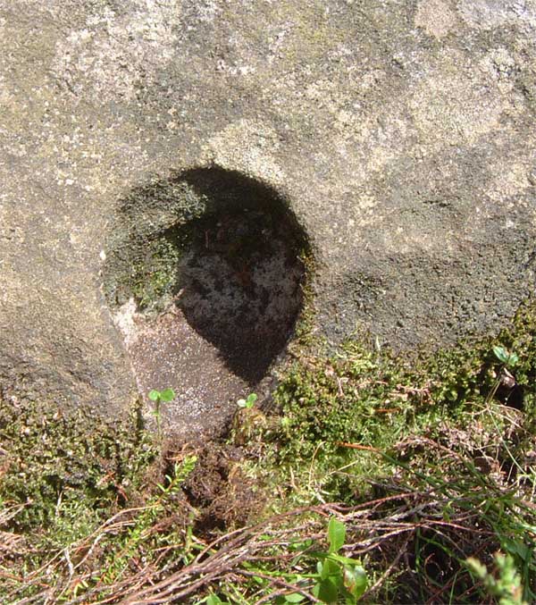
This is an odd one.
I've seen a few cross sockets in Northumberland, and I can see why some people have suggested this could be one, as it's probably been on one of the St Cuthbert pilgramage routes. The one time spring may infer some kind of fonty-ness, and whilst it does have metal chisel marks on part of the groove, it just doesn't fit the bill as either a font or a cross socket. Not the ones I've seen in these parts.
But it doesn't look like any of the prehistoric RA nearby either, but the area is dripping with such. So I'm going to hedge my bets and say that it's a prehistoric jobby that's been co-opted for early christian religious malarky.
Notes in the night
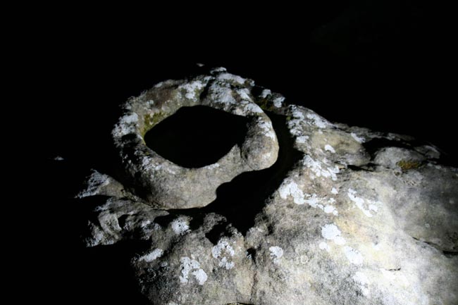
It serves as a very effective marker to let you know you're on track to get to Ketley Crag after dark. It looms out at you, and the hollow in the side of Chatton Park Hill becomes a yawning gulf of shadow.  |
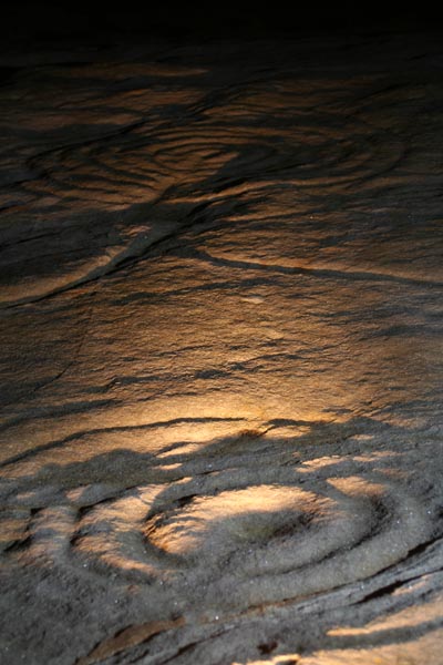
there was only one way to top the previous night's daftness in the Doddington Fog, so after another rock art free day, as soon as it was dark enough, Brother Slabdragger and I headed out past the Ketley stone:
 |
"A short walk around Chatton through open countryside, fields and farmland."
A 2 page pdf guide outlining public access to the Rock Art, as part of DEFRA's Countryside Stewardship Scheme. Once past the Ketley Stone, we made straight for the Megalithic Linoleum:
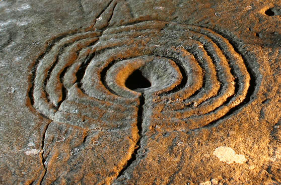
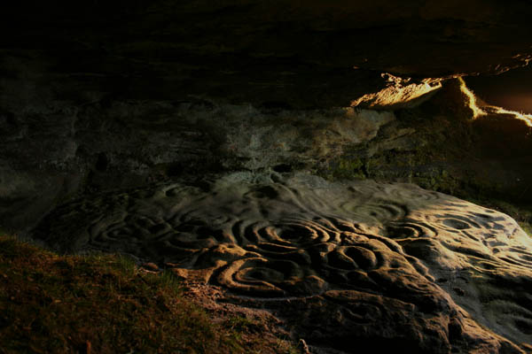
We were wary of disturbing the badgers, but they wee nowhere to be seen. Only the jawbone of a small mammal (a rabbit?) hinted at their presence. Ketley Crag is a powerful spot at any time, and in the dark, even more so. I think I've run out of words, hopefully the photo conveys enough of the sense of it. In retrospect, I should have set the camera up at a distance, so the effect of the light is in scale with the landscape. Next time mebbe.
Easter 2006
|
Wondrous Simonside
The following was deemed by it's author to be too long and irrelevant to constitute fieldnotes, so has mutated into something that only really fits as a weblog.
What makes a hill become worthy of the designation 'Sacred Hill'? Not in terms of categories of site postings on tma, but generally, in terms of what people feel about a place? Is there some sort of tickybox list of features, for example:
Does the putative sacred hill have:
a) Gods and things dancing about on the top, hoying thunderbolts at the humans below
b) The ability to make all the Locals in the pub, suddenly stop talking all at once, and start staring at you, frowning suspiciously, when you ask "So what's so special about the hill then?"
c) A big sign saying 'THIS IS A SACRED HILL'
d) Hardnosed, peer reviewed, meticulously executed Archaeological evidence that it has been the site of 'ritual activity'
e) An absolutely spiffing view
f) A quote from Tactitus saying something like "The hill is declared by the natives to be a place of pilgrimage, and the uncouth barbarians there make homage to their crappy spirits which in their ignorance, they mistake for proper gods"
g) Modern reports of UFOs, fairies, ghosts, and maybe even a quick 5-minute guest spot by the BVM herself
h) Sufficient electro-magnetic properties to cause a reading of 'Off-the-effing-scale' on a state of the art liquid gel circuitry Sacredhillometer, (One with the flashy lights, like a more modern version of the thing in Ghostbusters)
i) Eldritch lightning
j) Something indefinable, but definitely there, in a 'you can't say what it is, but you know it when you see it' kind of a way.
k) More eldritch Lightning.
Who knows? Not I. But I do feel that Simonside Hills merit the appellation 'Sacred'. Not that I could actually say what the feth 'Sacred' means. Special is possibly explanatory enough. But whatever 'Sacred' is, Simonside is it.
I've been able to see this place for most of my life, on the edge of the horizon to the North of Tyneside. Every time you go up one of the ridges near the Tyne, you can see the distinctive humps of these hills, silhouetted in the distance, particularly so at sunset in the summer, when the light fades behind them. They have a presence which extends for miles. They indicate the start of the Cheviots to someone who likes hills, this is enough in itself. These hills represent, to a slightly loopy post-industrial dweller of the Tyne as myself, a sense of security and a sense of continuity. For when seen from the wrecked landscapes of the Tyne, in counterpoint to the gaping wounds that are the opencast works on the costal plain, beyond the enclosed estates of the post-riever years, Simonside sits unconcerned, as it always has done, because it's a hill. As far as I've ever been able to work out, hills don't get concerned about much.
Of course much of this sense of the unchanging permanence of Simonside, is illusion, It has been forested, deforested, reforested and finally become moorland. It's slopes were once buzzing, comparatively speaking, as Lorenshaws hillfort was built on it's edge. It's footslopes have probably been arable at one point at least, but that's not the point, the point is, to me, Simonside represents something timeless and constant, in a landscape of hurly-burly alteration and strife.
And this is confirmed by a visit on a sunny day. The timelessness was lessened in one sense, in that the crags are so eroded, the passage of time is written on them plainly. The numerous solution holes are scoured wide by the action of wind and rain, which will be quite fierce at times, as this is a very exposed place. Then flitting on the periphery of possibility, some of the solution holes are just odd enough to suggest rock art.
Tales recorded in the 19th century, but possibly of much older origin, mention the "dwarf-like inhabitants of the darker recesses of the hill".
These entities are known collectively as the 'Duergar', a term which is allegedly confined to Simonside. The Duegar apparently were serious tricksters, with a penchant for leading the unwary over precipices in the mist.
See references to the writings of D.D. Dixon in Paul Frodsham's 'Archaeology in the Northumberland National Park' CBA, 2004.
ISBN 1-902771-38-9
Nothing fancy, just cups and grooves, but given the severity of weathering, it feeds the imagination to know that further down the hill, at Lordenshaw, are some fine panels of complex motifs. Some of the patterns made by the action of the elements suggest stylised animals, particularly snakes, others are familiar abstract motifs such as spirals, but none of these are the work of human hands. In a couple of places, particularly on Dove Crag.
There are pillars of eroded sandstone forming small scale versions of the Cheesewring on Bodmin moor. These natural sculptures are maybe sufficiently strange to have been recipients of special status in prehistory.
 http://www.themodernantiquarian.com/img_fullsize/29873.jpg " alt="Dove Crags"> http://www.themodernantiquarian.com/img_fullsize/29873.jpg " alt="Dove Crags">
This profusion of unusual textures is echoed on a larger scale by the overhangs and crannies, which raise the tantalising possibilities of prehistoric use of the rock shelters that abound on the crags. A good one is on the northern edge of Dove Crag, another is Old Stell crag. Some of these shelters are very silted up, others overgrown, but strip a few thousand years away, and it's easy to imagine Mesolithic folk thinking "Here, this is a good place to stop". And well they should think that, for it has shelter, but affords a view that is as good as you will get if you want to watch the land about. I kid thee not, you can see Penshaw Hill on Wearside to the south, even the hills of Durham. Way past the border into Scotland to the west, up past Alnwick to the north, and to the sea from to the east. It's a full 360degree view, extending for over 50 miles in some directions. Absolutely perfect if you want to watch out for gangs of fourlegged food piling across the plains to the hills, or even to just sit and watch the stars rise. There's even a convenient water supply in the pool at the bottom of Old Stell Crag, very picturesque as well as practical.
The idea that this place has been held sacred in prehistory, is possibly supported by the fact that there are numerous monuments in the surrounding area, many seemingly placed to afford a view of Simonside. There are cairns on the hills immediately to the west, where the horizon is closest. To the east, there are the panels of rock art, burial cairns, and standing stone at Lordenshaws], right at the foot of the hill. There are more panels, some including confirmed manmade versions of the extra large cups on the crags, tracing the path of a stream down to the river Coquet. On the other side of the Coquet, there are more standing stones, cairn fields and rock art. To the south, there is rock art and a four-poster circle at Fontburn and the possible (strong emphasis on possible) ritual enclosure at Nunnykirk. Simonside is visible from the the buria mound next to The Warrior Stone. I couldn't swear to it, but there's a chance the standing stone alignment of The Five Kings to the west near Elsdon, also has a relationship with the Simonside hills, if not directly to Simonside itself. Even fifteen miles to the south, the Stone and mound of The Poind and his man at Bolam is placed on a ridge with a clear view of the distinctive profile of Simonside.
I am told that sacred hills are the focal points of ritually significant landscape relationships, explaining the possible absence of monuments on these hills themselves. If this is the case, then Simonside also has a vote from me in that it links two other possible sacred hills. The first of these, Penshaw, to the south on Wearside, has greater likelihood of sacredness than the second, the Bowden Doors near Wooler, which are visible to the north of Simonside.
One last thing that clinched a love for this place, was the appearance of an adder right in the middle of the path. After a few hours of scrambling about crevices and avoiding the precarious mats of vegetation that hide many clefts from the unwary, the sudden awareness that there had possibly been adders right next to me, put an extra spin on the experience.
I can honestly say that my afternoon bouncing about this place was one of the best excursions I've ever had. Whilst you get a good view from the top of Cairngorm, Helvellyn or Snowdon, the view from the top of Simonside though not as spectacular, is (for me) a view of home, and one that drips with hidden, intangible shadows and echoes of unwritten histories. It has a real 'Power of place' to borrow a phrase from Stan Beckinsall's book on Northumberland. Even on a nice sunny day, it wasn't hard to feel that there could have been otherworldly entities nearby, but that were keeping quiet in the background of awareness. For on that day at least, Simon side was welcoming visitors. It might be a tad fearsome if 'It was dark and windswept night'.
(Might even get a bit of eldritch lightning, that would be a plus, you can't go wrong with eldritch lighting effects on hills.)
PS: I was lucky enough to get to be next to the window in a plane flying over Northumberland, a few days after the visit described above, and got to see the Simonside hills from the air. They completely stand out in the surrounding landscape. Like the Thornborough Henges, they have even more presence when seen from above.
|
|
I like the Prehistoric Rock Art of Northumberland:
Ketley Crag
Chatton
Weetwood Moor
Dod Law
Roughting Linn
Lordenshaw
Fowberry Cairn
Hunterheugh
Old Bewick
Morwick
Currently obsessed with waving torches at things, often including rocks, as a prelude to some serious waving of torches at rocks that will inevitably appear here on tma at some point :)
|
