|
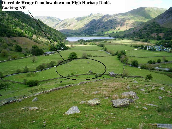
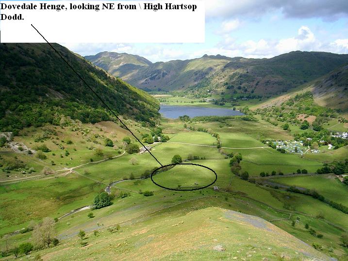
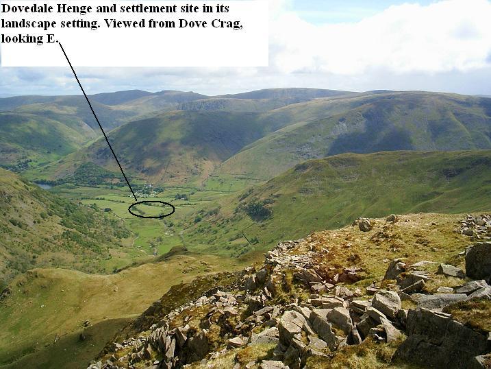
This site is thought to have started its life as a henge, later adapted by the Romano-British as a settlement with hut-circles. There is also evidence of a round cairn. See the ADS link below:-
http://ads.ahds.ac.uk/catalogue/search/fr.cfm?rcn=LDNPHER08-2983
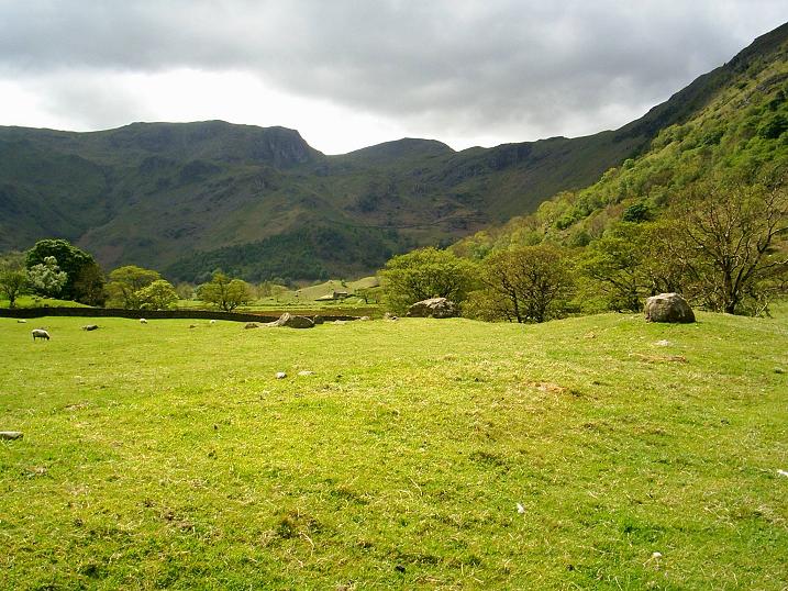
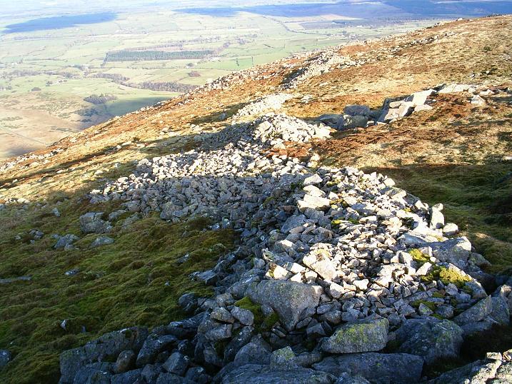
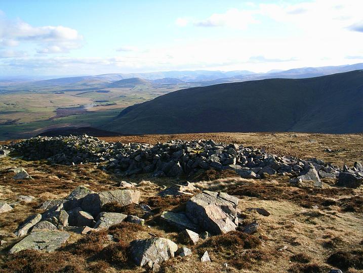
It's about 100 feet in diameter, with what appear to be standing stones on top of the bank, in places, which is highest at the northern quarter, and seemingly constructed of rocks, which appear on the surface in this quarter.
When you visit it, you are struck more by its henge-like appearance than by any hut-circles, and the "standing stones" certainly seem too coincidental to be true. Some do appear to be large boulders "placed" on top of the bank, but others seem to have been erected. Even so, why are they on top of the bank if they're natural?
Visit it, and decide for yourselves. It's worth it for the views into beautiful upper Dovedale. The Brotherswater campsite, Sykeside Farm, is a few hundred yards away, as is the pub, always a bonus.
|
The Museum of Kendal, one of the oldest in the country, covering a wide range of archaeology, as well as the geology and natural history of Cumbria, and the old counties of Cumberland and Westmorland.
|
   
|
|
Eterwater is a beautiful place, full of lifelong memories for me. There is a supposed ancient cairn in the outskirts, but it's scratchng at the truth. Many investigations leave me doubtful. I want a burial cairn at Elterwater.
|
13/04/09
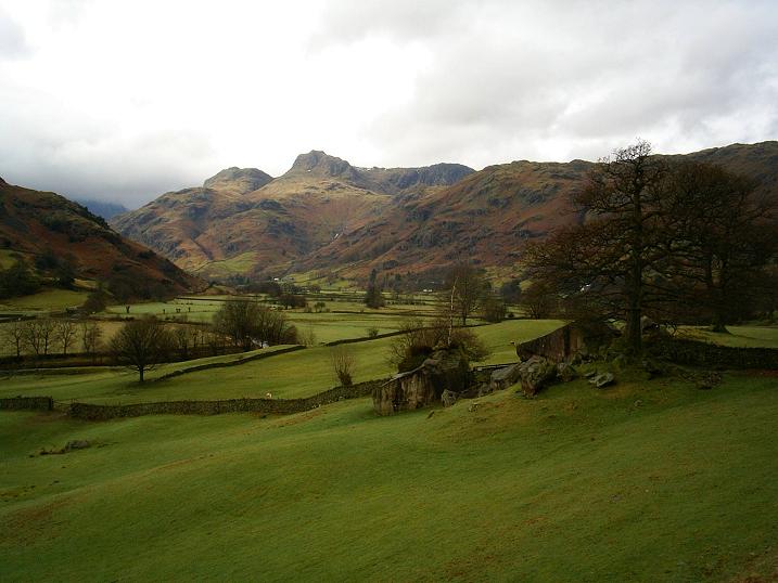
Easter Monday in the Lakes, eh? Deserted on mine and Mrs. TEs' walk. From Elterwater, over the shoulder of Lingmoor, into the twin valley of Little Langdale and a pastoral idyll. This is what Great Langdale must have been like before the internal (infernal more like) combustion engine.
We continued over the ancient (not prehistoric) Slater Bridge, and along to Fell Foot. In days gone bye, and in the second half of the 20th century, an old chap used to sit by the fell gate, opening and closing the gate to cars for a penny or two.
Sorry to go on, but we continued a couple of hundred yards up Wrynose Pass, before cutting across Blea Moss. According to local writer Bill Birkett, in his book (Great Langdale, A Year in the Life of), it's a site of a neolithic/bronze age burial cairn, not that I've found it. We continued to delectable waterfalls, and on to Blea Tarn. Then we had our sarnies on the shoulder of Lingmoor, with Great Langdale below our boots.
I looked, through the bins, to the Pike of Stickle, and Harrison Stickle stone axe factories. Knowing where they are helps.
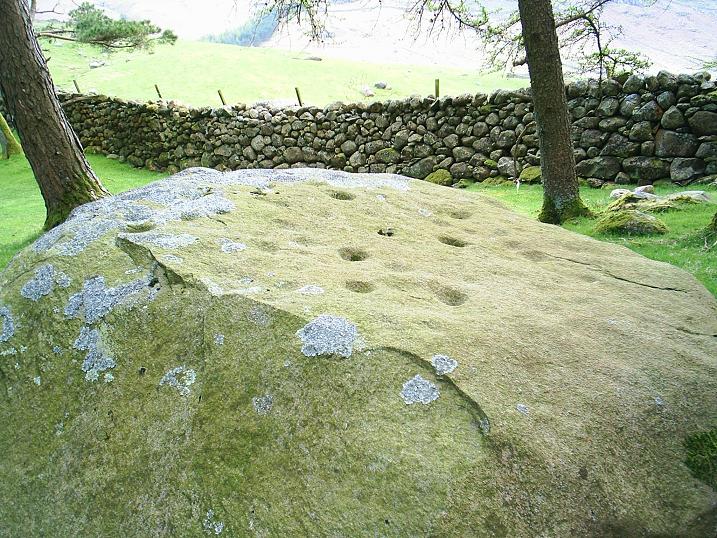
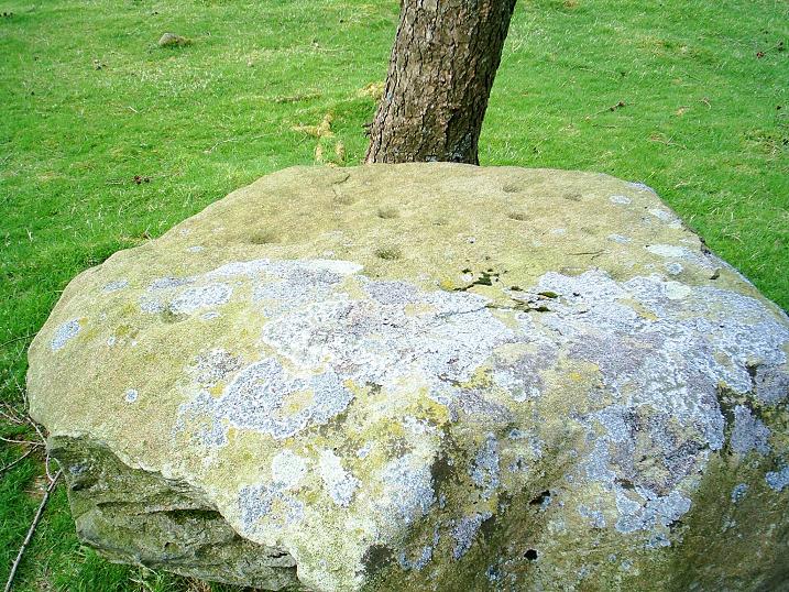
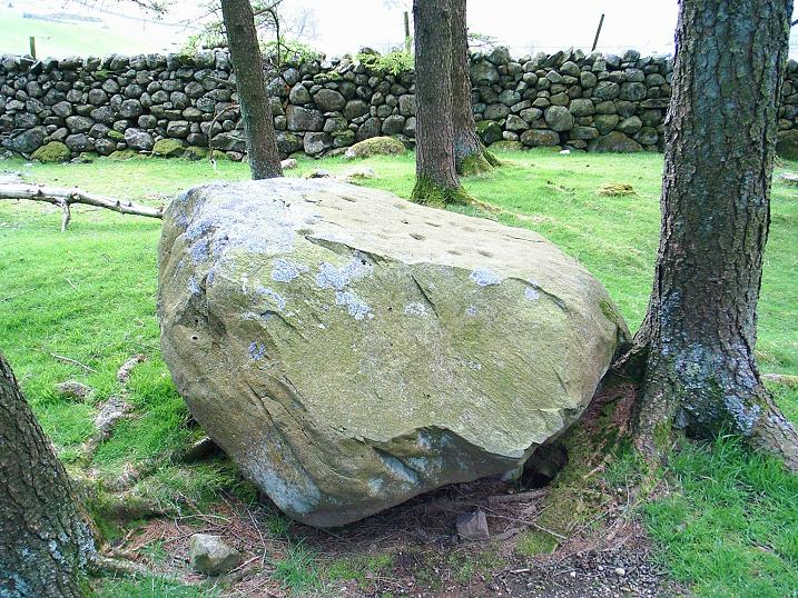
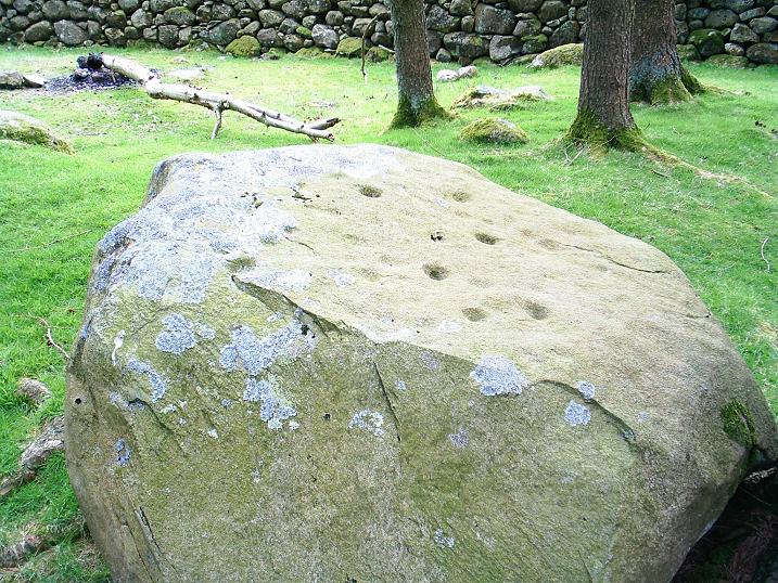
We descended soft, grassy, and mossy slopes to the Great Langdale campsite, stopping to admire the cup-marked boulder, amongst the sighing trees.
It does make you wonder what it was all about. Something to do with the axe factories? Why just the one boulder, when half-a-dozen similar ones lay about? Why just cup-marks, so near the axe factories, especially when the Copt Howe boulders are so elaborate?
The beer in the friendly, and familiar, beer garden at the Old Dungeon Ghyll finished off a perfect day.
|
   
|
  
|
Skara Brae Sea Wall Set For Work.
Work to strengthen the foundations of the sea wall near the famous Neolithic village of Skara Brae in Orkney is about to begin.
Waves have affected a section of concrete on which the protective walling was built, which could lead to more damage.
Historic Scotland has started a project which will involve digging down to insert new reinforcements.
It is described as important and highly-skilled work.
Stephen Watt, Historic Scotland district architect, said: "The area affected is a bit beyond Skara Brae itself, but it is important because it stops the sea outflanking us.
"These are interim measures which help protect an enormously important part of Scotland's heritage.
"We are currently working with a number of other groups and organisations to put together a strategy to protect the entire bay from the effects of natural erosion."
The settlement was inhabited 5,000 years ago.
http://news.bbc.co.uk/1/hi/scotland/north_east/7840463.stm
|
Ancient Burial Ground Uncovered.
More than a dozen skeletons thought to be thousands of years old, have been found by Oxford archaeologists working at an ancient burial site in Dorset.
Excavations are taking place at the site in Weymouth before builders move in to build an access road to the Olympic sailing centre for 2012.
Archaeologist David Score said they had catalogued finds from almost every period of human life.
He said it "really added to knowledge of the Bronze and Neolithic eras".
"Building the relief road has given archaeologists an excuse to excavate and record finds dating back thousands of years," Mr Score said.
"I think it is very important because it's not very often that you get the opportunity to excavate an area of this size, in a location of such importance with so many burials from a wide span of time.
"I think once we have done all the analysis it really will contribute quite a lot to the corpus of knowledge that we've got about the Bronze Age and Neolithic periods in this area.
"We found more than a dozen skeletons they're in various states of preservation. Some are fairly poorly preserved, but the later ones, particularly the Roman ones are fairly well preserved."
All the finds are being taken back to Oxford where they are being catalogued.
Scientists will also look for small fish bones or charred plant remains to try and find out more about ancient eating habits.
The items will eventually be returned to Dorset where they will be put on display in a museum.
http://news.bbc.co.uk/1/hi/england/oxfordshire/7804287.stm
|
"Oldest human brain" discovered.
Archaeologists have found the remains of what could be Britain's oldest surviving human brain.
The team, excavating a York University site, discovered a skull containing a yellow substance which scans showed to be shrunken, but brain-shaped.
Brains consist of fatty tissue which microbes in the soil would absorb, so neurologists believe the find could be some kind of fossilised brain.
The skull was found in an area first farmed more than 2,000 years ago.
More tests will now be done to establish what it is actually made of.
The team from York Archaeological Trust had been commissioned by the university to carry out an exploratory dig at Heslington East, where campus extension work is under way.
The skull was discovered in an area of extensive prehistoric farming landscape of fields, trackways and buildings dating back to at least 300 BC.
The archaeologists believe the skull, which was found on its own in a muddy pit, may have been a ritual offering.
"There is something unusual in the way the brain has been treated, or something that it's been exposed to that has preserved the shape of it." York Hospital neurologist
It was taken to York University where CT scans were used to look at the skull's contents.
Philip Duffey, the consultant neurologist who carried out the scans, said the find was "amazing".
"It's exciting that scanning has shown structures which appear to be unequivocally of brain origin.
FROM THE TODAY PROGRAMME
More from Today programme
"I think that it will be very important to establish how these structures have survived, whether there are traces of biological material within them and, if not, what is their composition."
He added: "This could be the equivalent of a fossil. The brain itself would generally not survive. Fatty tissues would be feasted on by microbes.
"This isn't like the remains found in bogs; it doesn't have any skin on the skull or any tissue remains elsewhere.
"There is something unusual in the way the brain has been treated, or something that it's been exposed to that has preserved the shape of it."
Dr Sonia O'Connor, research fellow in archaeological sciences at the University of Bradford added: "The survival of brain remains where no other soft tissues are preserved is extremely rare.
"This brain is particularly exciting because it is very well preserved, even though it is the oldest recorded find of this type in the UK, and one of the earliest worldwide."
The skull was found in an area first farmed more than 2,000 years ago
The find is the second major discovery during investigations at the site.
Earlier this year, a team from the university's department of archaeology unearthed a shallow grave containing the skeleton of a man believed to be one of Britain's earliest victims of tuberculosis.
Radiocarbon dating suggests that the man died in the fourth century, the late-Roman period.
The Vice-Chancellor of the University of York, Professor Brian Cantor, said: "The skull is another stunning discovery and its further study will provide us with incomparable insights into life in the Iron Age."
Specialists now hope to carry out further tests on the skull to establish how it has survived for so long, and perhaps more about the person whose brain it was.
http://news.bbc.co.uk/1/hi/health/7777385.stm
|
Ancient rock carvings discovered.
More than 100 new examples of prehistoric art have been discovered carved into boulders and open bedrock throughout Northumberland and Durham.
The 5,000-year-old Neolithic carvings of circles, rings and hollowed cups, were uncovered by volunteers.
One of the most interesting discoveries was an elaborately carved panel on Barningham Moor, near Barnard Castle in County Durham.
English Heritage now wants to extend the project to Cumbria.
Kate Wilson, inspector of ancient monuments at English Heritage, said: "We know virtually nothing about this art. That's the exciting part of this discovery.
"What we need to do now is to discover how this art relates to other prehistoric features in the landscape.
"We are talking about very simple and abstract art, using circles, lines and triangles. Mostly the designs are pecked into stone in the shape of simple cups and rings."
Archaeologists have discovered thousands of examples of prehistoric rock carvings in the area in recent years.
Many feature on a website backed by Newcastle University, which includes about 6,000 images.
Ms Wilson added: "We are sure there remains a lot that is still undiscovered in Cumbria."
http://news.bbc.co.uk/1/hi/england/7534510.stm
|
Hunt for ancient manor and circle.
A dig to unearth the remains of a 14th Century manor house and stone circle is to take place in the Lake District.
The search will take place at Castlerigg, near Keswick, where there is already a well-preserved stone circle dating from 3,000 BC.
The hunt is taking place after a farmer found what he believed to be the remains of a manor in his field.
It will be lead by Bassenthwaite Reflections with the permission of English Heritage.
Volunteers with an interest in history are being urged to take part.
A spokesman for the Castlerigg survey, said: "Aerial photographs and ground searches have revealed markings of two potentially important sites.
"There are 14th century references to the castle, which was abandoned around 1460. Notes written in 1770 state the ancient seat of the lords of the manor of Derwentwater went into ruins.
"In trying to find evidence of the manor we'll be looking for building foundations and trenches.
"Our volunteers will also be asked to try to find buried stones or filled in sockets which might have formed a ring."
http://news.bbc.co.uk/1/hi/england/cumbria/7533904.stm
|
Excavations reveal Stone Age life.
Excavations at the ancient monument Stonehenge reveal it was used as a cemetery at the time it was created just after 3000 BC.
Many archaeologists had previously thought people had been buried at the site between 2700 and 2600 BC.
This was before the larger stones were put in place.
The new dates give strong clues about the original purpose of the monument and show that its use as a cemetery went on for more than 500 years.
"It's now clear that burials were a major component of Stonehenge in all its main stages," said Mike Parker Pearson, archaeology professor at the University of Sheffield, whose team has been excavating the Wiltshire site.
"Stonehenge was a place of burial from its beginning to its zenith in the mid third millennium BC.
"The cremation burial dating to Stonehenge's sarsen stones (the larger stones) phase is likely just one of many from this later period of the monument's use and demonstrates that it was still very much a domain of the dead."
The earliest cremation burial dated - a small pile of burned bones and teeth - came from a pit around Stonehenge's edge known as the Aubrey Holes and dates to 3030-2880 BC.
The second burial, from the ditch surrounding Stonehenge, is that of an adult and dates to 2930-2870 BC.
The most recent cremation, Professor Parker Pearson said, came from the ditch's northern side and was of a 25-year-old woman.
This dates from 2570-2340 B.C, around the time the first arrangements of sarsen stones appeared at Stonehenge.
Another 49 cremation burials were dug up at Stonehenge during the 1920s, but all were put back in the ground because they were thought to be of no scientific value.
Archaeologists estimate that up to 240 people were buried within Stonehenge, all as cremation deposits.
http://news.bbc.co.uk/1/hi/england/wiltshire/7425959.stm
|
Kit helps pupils enjoy monument
Kit helps pupils enjoy monument
The pack aims to make learning about the monument fun
A new teaching kit has been produced to help children get more out of school visits to Avebury and surrounding monuments in Wiltshire.
The resource is aimed at key stage two and three pupils and includes on-site investigation sheets, puzzles and treasure hunts.
"The site is steeped in a rich and mysterious history," said Lucy Bradley, Education Manager for English Heritage.
"We want to encourage more schools to come to Avebury World Heritage Site."
The kit came about after last year's successful project at Silbury Hill to stabilise the ancient man-made mound.
"Pupils from two primary schools and a secondary school visited while the work was in progress," said Ms Bradley.
"The visit was such a success. It really helped the children to get an in-depth learning experience of the mysterious hill so we thought it would be great if we could create a Teacher's Kit which encourages active learning for visits to the whole World Heritage Site."
Avebury World Heritage Site is a Neolithic landscape which encompasses Avebury Stone Circle, West Kennet Long Barrow and Avenue, The Sanctuary, Windmill Hill and Silbury Hill.
http://news.bbc.co.uk/1/hi/england/somerset/7381758.stm
|
Stonehenge tunnel to be scrapped.
Winterbourne Stoke's bypass is also threatened
Plans for a tunnel taking traffic away from Stonehenge are likely to be scrapped within days.
The BBC has learned the government believes the tunnel's cost of £510m is too expensive.
Transport correspondent Paul Clifton said an announcement was due next week which will "almost certainly spell the end of the tunnel".
He said Transport Secretary Ruth Kelly would announce another review of the options, the 10th such review to date.
ALTERNATIVES TO THE TUNNEL
A northern route - which would have a junction with the A360 then go south of Larkhill and rejoin A303 at the Countess roundabout at Amesbury. It would involve a cut-and-cover tunnel
A southern route - which would have a junction with the A360 then go south of Stonehenge before rejoining the A303
A cut-and-cover tunnel - like the first tunnel scheme - but closer to the surface than a bored tunnel
A partial solution - which would include closing the A344 at its junction with the A303 and offer options for the end of the Winterbourne Stoke bypass
English Heritage has refused to comment on the story until the government makes an official announcement.
A Department of Transport spokesperson would only say: "An announcement will be made in due course".
The 1.3 mile (2.09km) tunnel was recommended after a public inquiry in 2004 but was put on hold by the Department for Transport (DfT) when its costs rose to £510m.
The DfT insisted on re-examining some of the options the public inquiry ruled out.
Four options to protect the World Heritage site and provide a bypass for the nearby village of Winterbourne Stoke had previously been unveiled by the Highways Agency in February 2006.
They included a "cut and cover" tunnel, which is cheaper than a deep-bore passage and involves creating a shallow channel and covering it with a roof and a bypass to the north or south and changes to the Countess Roundabout.
News the tunnel is now unlikely to be built has a knock-on effect for the people of Winterbourne Stoke which has the A303 as its main street and had been promised a bypass as part of the wider plan.
Councillor Ian West, who lives in the village, said: "We should be challenging them now to disconnect the two objects because Winterbourne Stoke is still suffering from over 30,000 vehicles a day thundering through it.
"We went through the public inquiry and there were no contentious issues on the line so what we want now is it disconnected then let's do Winterbourne Stoke and they can argue about Stonehenge for another century if they wish."
To date the total amount spent on the A303 Stonehenge Improvement from the time the scheme entered the roads programme in the late 1990s is £19m.
The cost of the public inquiry which was held in 2004 was £3m.
http://news.bbc.co.uk/1/hi/england/wiltshire/7103371.stm
|

Stonehenge's Huge Support Settlement
Archaeologists working near Stonehenge have uncovered what they believe is the largest Neolithic settlement ever discovered in Northern Europe.
Remains of an estimated 300 houses are thought to survive under earthworks 3km (2 miles) from the famous stone rings, and 10 have been excavated so far.
But there could have been double that total according to the archaeologist leading the work.
"What is really exciting is realising just how big the village for the Stonehenge builders was," says Professor Mike Parker Pearson of Sheffield University.
Allowing four per house, he estimates there could have been room for more than 2,000 people.
Analysis of the houses has also showed that some were higher status than others. This is the first evidence for social difference and hierarchy at the time of Stonehenge, indicating that the organisation of labour for moving and raising the stones was not egalitarian.
The settlement is buried beneath the bank of Durrington Walls, a great circular ditched enclosure.
Durrington Walls holds clues to the Stonehenge story
Geophysical survey and excavation work have revealed that the ditch and bank had been constructed in large sections, probably by separate work gangs.
A find of dozens of antler picks in one section of ditch gives some idea of the size of these work parties.
"From the number of antler picks left in the bottom of one section - 57 - if you allow two people with one pick plus a team of basketeers carrying the rubble away and you've got to have the sandwich makers as well.
"This suggests a minimum team size of 200. If the 22 sections of Durrington's ditch were all dug at the same time, that's a work force of thousands."
The settlement beneath Durrington Walls dates from around the time of the construction of Stonehenge's sarsen stones, about 2600 to 2500 BC.
For Mike Parker Pearson, the new evidence throws an important light on how Neolithic society worked - how people organised themselves to build mega-structures.
Bone and other artefacts are being dug up
Apply this to Stonehenge, and he believes there were groups of about 200-400 people working under a clan head, responsible for completing individual sections of the overall monument.
"It's possible that most of Southern Britain may have been involved at one stage or another," Parker Pearson says.
Other evidence from cow and pig bones found on the site suggests that people were coming into the area on a seasonal basis.
"This was a temporary settlement," he says. "They were not doing basic daily chores, not grinding corn, not raising animals. There were no baby pigs and cows. It looks like the livestock had been brought in."
And there is also evidence of feasting at Durrington Neolithic village such as bones still connected together.
"This is the sort of thing you are expecting at feasting occasions - discarded but still-edible joints of meat - when everyone has got enough to eat."
So far, only a fraction of the area has been excavated
The team has also found a tantalising artefact: a piece of chalk with cut marks that Parker Pearson believes was made by a copper axe.
He is not surprised at the evidence - as copper working in neighbouring parts of mainland Europe dates back to 3000 BC - but it would be the first evidence from Britain before 2400 BC.
The theory is also supported by the almost total absence of evidence of stone or flint axes in the village.
The current excavations at Stonehenge began four years ago and are part of a 10-year project.
Secrets of Stonehenge is on BBC Radio 4 at 2000 GMT on Monday, 5 November.
http://news.bbc.co.uk/1/hi/sci/tech/7078578.stm
|
New suspect in Skara Brae enquiry.
Police searching for vandals who scrawled graffiti at the site of the ancient Skara Brae settlement are now looking for a 35-year-old man.
The man, who might speak with a Liverpudlian accent, is said to be 5ft 6 in, of medium build with fair hair.
He may be using the name Brian Finlay and make conversation about the Celts, police on Orkney added.
Staff found the graffiti daubed on the 5,000-year-old site - including the words "Scouse Celts" - on Tuesday.
Monument managers said vandals had entered one of the houses at the site and drawn a smiley face, their name and the date with black marker pen, defacing both the dresser and one of the bed posts.
It was initially thought that the vandalism may have been carried out by tourists travelling round the island in a silver people carrier.
However, police ruled the group out of their inquiries after questioning the vehicle's occupants earlier.
The man they are now looking for is believed to be sleeping rough on Orkney and has a backpack with him.
Historic Scotland, which is responsible for the upkeep of the world heritage site, said that it was liaising with its conservation centre in Edinburgh to find the best way of removing the graffiti as soon as possible.
"Graffiti removal on buildings of historical or architectural importance needs to be handled sensitively," said a spokeswoman.
"The careful process needs to ensure any long-term damage caused by the graffiti is kept to a minimum and the stone itself is not further damaged as part of the graffiti removal process.
"Our visitors have reacted with surprise and sympathy to the damage caused."
The cost - which is expected to be substantial - is not yet known.
Skara Brae was first discovered following a major storm in 1850, which battered the island to such an extent that an outline of a series of stone buildings was revealed.
A series of excavations was carried out over the next century, finally revealing eight stone dwellings which were originally believed to be an Iron Age settlement.
However, in the 1970s radiocarbon dating showed that the village was originally built between 3200 and 2200 BC.
http://news.bbc.co.uk/1/hi/scotland/north_east/6951100.stm
|

|

|
   
|
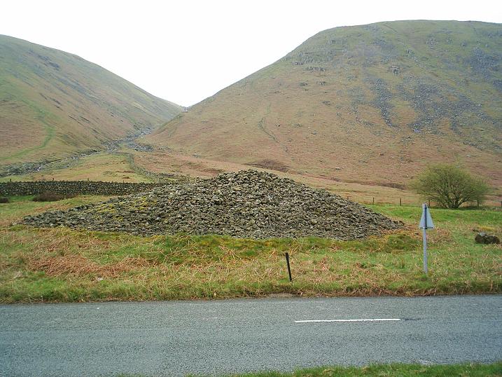
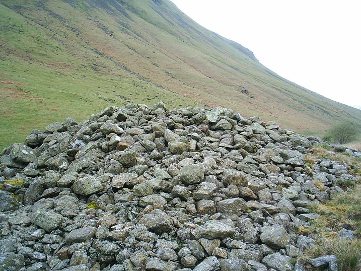
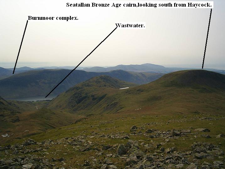
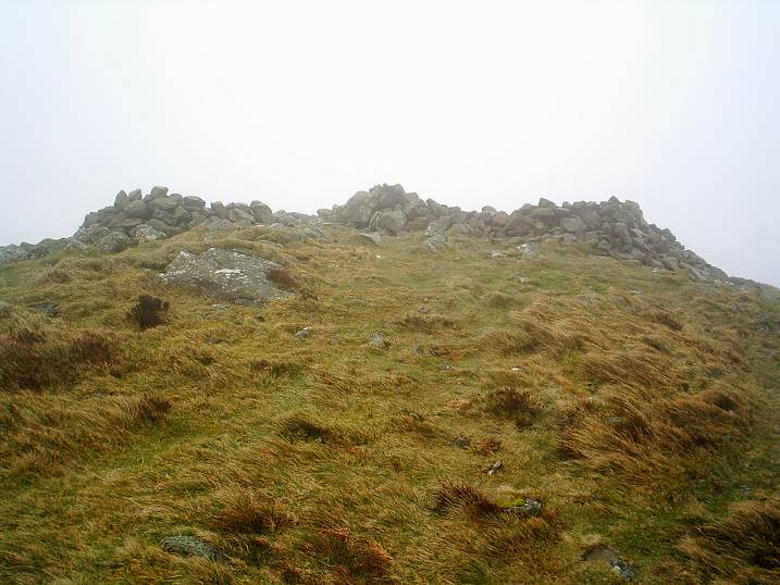
This is a huge Bronze Age cairn, which, typically, for Cumbria, has been reduced down by fellwalkers, who, in their ignorance, have done what they do: mess about with summit cairns for their own shelter.
How ignorant "modern" man is. From the middle ages onwards we have helped to destroy numerous ancient monuments, and, on the Cumbrian fells, are still free to do so.
As Francis Pryor writes about in his outstanding book "Britain BC", in the uplands of Britain the barrows change from earthen or megalithic to those made of stones: the cairns.
The cairns don't seem to be protected very well. In fact, in reality, they don't seem to have any protection. The archaeological records of these places in Cumbria are vague or non existant. Who cares about these remote cairns, which is what they all sem to be?
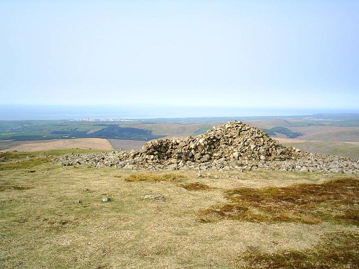
It's a lonely summit - you won't meet anyone up here. From the cairn the views are outstanding. On a clear day Scotland, North Wales, and the Isle of Man can be seen, and on exceptional days the mountains of Ireland have been claimed to be in view.
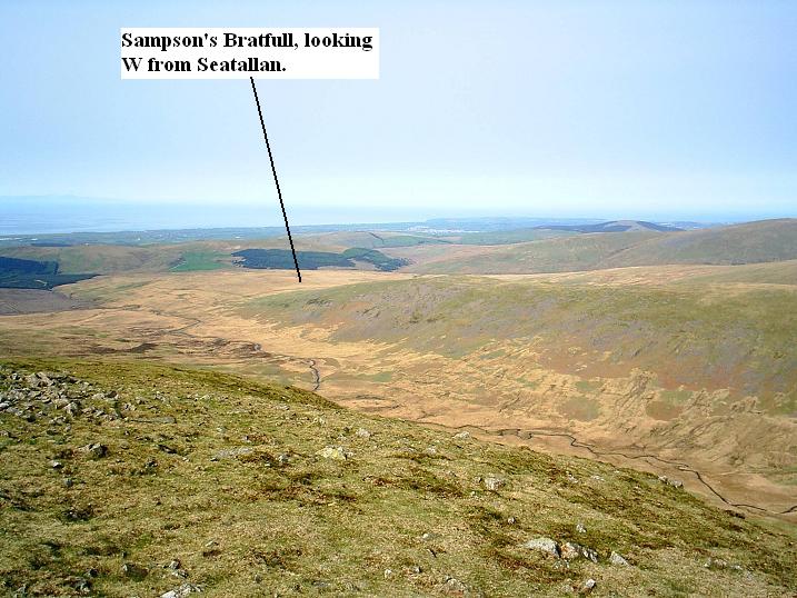
The Stockdale Moor (Sampson's Bratfull) site is seen well from here, as is the modern eyesore of Sellafield (formerly Calder Hall, Windscale, etc.). Ancient and modern. Also, there is a good view of Burnmoor Tarn, and the cairn at the northern end, Maiden Castle. It makes me think of sightlines.
|
Dig Planned for Lakes Beauty Spot
Archaeologists are hoping to unearth ancient treasures during excavations in a Cumbrian valley.
Volunteers are needed to join archaeologists during the digs in the Duddon Valley in the south west of the Lake District beginning on 30 June.
Much of the work will focus on the cairn at Seathwaite Tarn - a mound of landmark and burial stones.
The Ring Cairns to Reservoirs Project is backed by a £50,000 Heritage Lottery Fund grant.
Around 60 local people have been trained in archaeological survey techniques.
The project will be led by the National Park Authority's senior archaeologist John Hodgson, with help from Oxford Archaeology North, students from Durham University and the Duddon Valley Local History Group.
Part of the work will involve pollen analysis to find out what Seathwaite Tarn and the surrounding vegetation could have looked like during the Bronze Age.
Chairman John Hoggett, of the local history group, said: "This will be the first excavation of a ring cairn in the Lake District and we are hoping that it will give us clues as to what was happening here thousands of years ago."
http://news.bbc.co.uk/1/hi/england/cumbria/6243312.stm
|
Dig at Ruins Uncovered by Storm
Archaeologists are excavating the remains of houses believed to date back 2,000 years after they were uncovered by a ferocious storm.
Fife-based charity Scottish Coastal Archaeology and the Problem of Erosion (Scape) is leading a community project at the site on North Uist.
Scape is investigating the suspected Iron Age round houses before they vanish in another powerful storm.
The organisation is also carrying out work at another historic site in Brora.
Violent weather exposed the ruined houses at Baile Sear, North Uist, in January 2005.
Tragically, a family of five died on Benbecula in the same storm.
Scape has helped Historic Scotland survey 30% of the Scottish coast, which runs to thousands of miles.
Three thousand sites of historic interest have been located so far.
The sites include ancient Norse houses, burial sites, brochs and World War II observation posts.
Scape co-ordinator Tom Dawson, a research fellow at the University of St Andrews, said Historic Scotland was helping to fund the project at Baile Sear.
He said: "People had seen bits and pieces of the remains before, but as the cobbles and sand washed way the structures are just sitting there on the beach.
"There are thought to be two roundhouses. We believe they are Iron Age making them 2,000 years old."
Scape has started investigating the remains of salt pans on sand dunes at Brora in Sutherland.
The large metal trays were filled with sea water and heated below by fires fuelled by coal from a nearby pit to produce salt.
Brora is the location of the most northerly deep mine in the British Isles and coal was dug from it from 1598 until 1974.
A total of 15 miners died in a coal mine roof fall in the 18th Century.
Set up in 2001, Scape has helped Historic Scotland survey the Scottish coastline for archaeological sites.
Mr Dawson said climate change posed a serious threat to many of the relics record so far.
He said: "Erosion has always happened, but it is said that climate change and global warming will leave Scotland one of the places worst affected by storms."
The charity has been targeting its resources at sites where the local communities have shown a willingness to excavate or try and protect them.
http://news.bbc.co.uk/1/hi/scotland/highlands_and_islands/6238302.stm
|
  
|
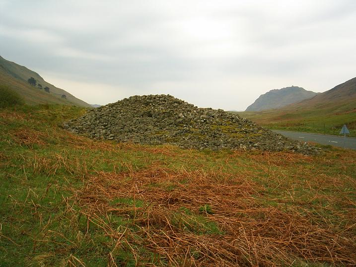
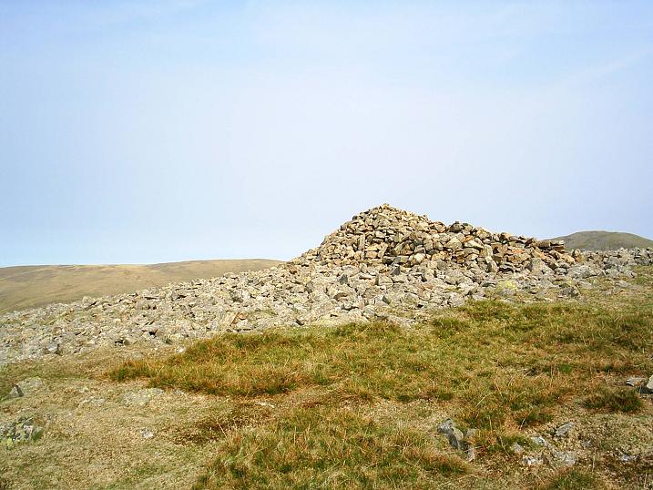
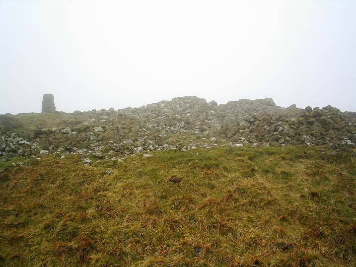
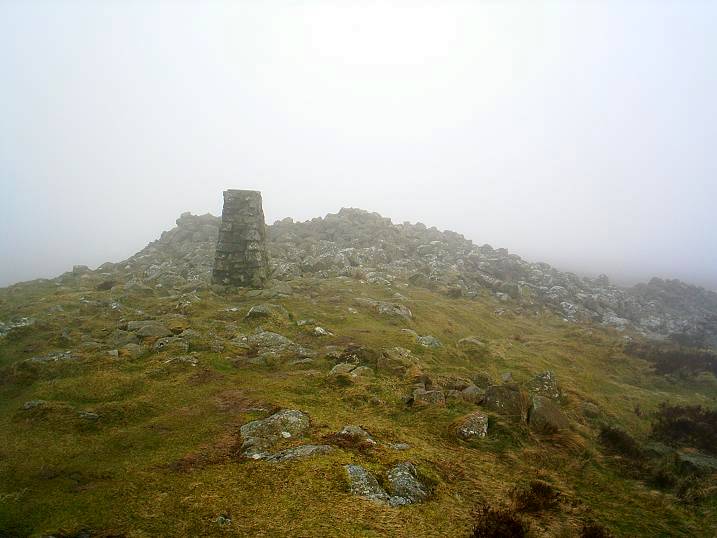
I visited this site on 10th March 2007, on a morning when the wind was blasting rain out of the west, and the clouds down on the top, depriving me of the wonderful view.
The Bronze Age cairn has been messed with, and the rocks have been scattered a bit. It must have been a substantial cairn in its original form. Two low-walled shelters have been constructed from the hoary old stones, providing shelter for the intrepid traveller, who can huddle from the wind. It's an exposed place, at just short of 1,500 feet above sea level.
This cairn will appeal to the lover of the more obscure evidence of prehistory.
|
Experts reveal 'ancient massacre'
Bones found at a prehistoric burial site indicate they belonged to victims of an ancient massacre, say scientists.
Remains of 14 people were discovered at Wayland's Smithy, near Uffington White Horse, Oxfordshire, in the 1960s.
Latest techniques date the bones at between 3590 BC and 3560 BC, and have led experts to believe the people may have died in a Neolithic Age massacre.
English Heritage carried out the work with the help of Cardiff University and the University of Central Lancashire.
Michael Wysocki of the University of Central Lancashire says the findings suggest the Neolithic Age was more violent than previously thought.
This dating programme demands a revolution in our thinking about prehistory.
Alex Bayliss, English Heritage
The victims - three of them probably killed by arrows - could have died in a rush for land or livestock, he added.
He said: "We know one person was shot through the lower abdomen because we have found the tiny tip of a flint arrowhead embedded in their pelvic bone.
"We also know that the bodies of two people were scavenged and partially dismembered by dogs or wolves before their remains were buried in the monument.
"All this new evidence suggests that the period between 3625 BC and 3590 BC may have been one of increasing social tension and upheaval."
The research also indicates that the use of Neolithic long barrows was short-lived - and did not take place over hundreds of years as previously thought.
English Heritage radiocarbon dating expert Alex Bayliss said: "With this research, we can now think about the Neolithic period in terms of individuals and communities and make useful and revealing comparisons between their choices and behaviour in the remote past.
"This dating programme demands a revolution in our thinking about prehistory and not just that of early Neolithic burial monuments in southern Britain."
http://news.bbc.co.uk/1/hi/england/oxfordshire/6439401.stm
|
  
|
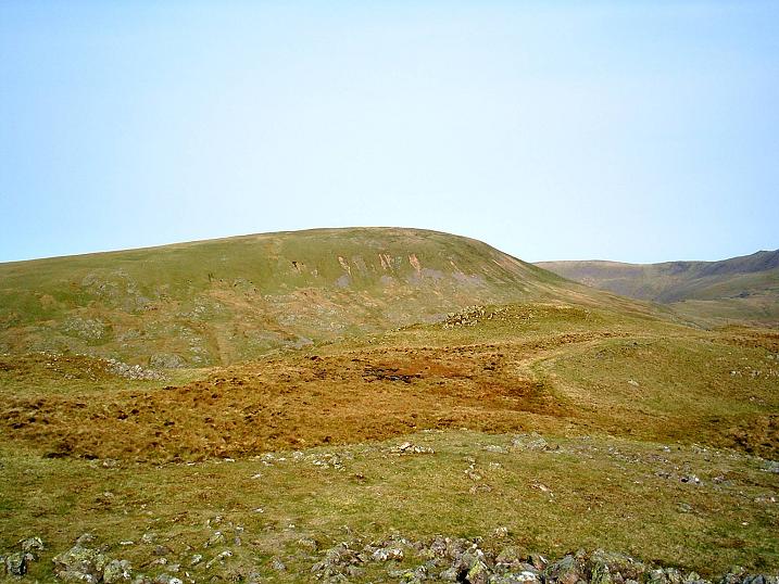
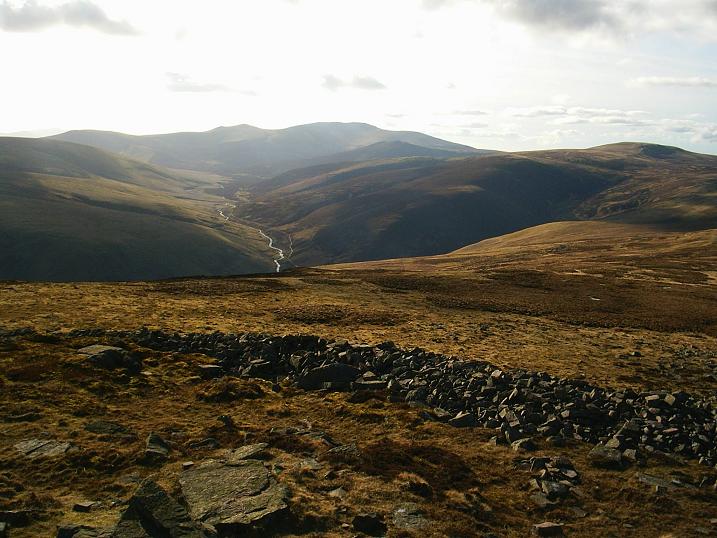
Earthwork remains of an Iron Age hillfort containing levelled rock-cut hut platforms, according to ADS, but they're hard to spot amongst the heather. It's quite a small fort, sited on top of a rocky outcrop. There's not a lot to see, but it's obvious that the site would be easily defended.
You can see Castlerigg Stone Circle from the top, if you know where to look, and have binoculars.
It was a cold day of sub-zero temperatures, when me and my mate, Pie Eater, visited. The ice, under the light covering of powder snow, made for an interesting ascent. The Forestry Commission have spoilt the area somewhat, but the short detour to the top of nearby Raven Crag will reward the intrepid antiquarian with spectacular views of Thirlmere.
|
Eyes I dare not meet in dreams
In death's dream kingdom
These do not appear:
There, the eyes are
Sunlight on a broken column
There, is a tree swinging
And voices are
In the wind's singing
More distant and more solemn
Than a fading star.
T.S.Eliot "The Hollow Men"
|
|