27/05/06 My latest visit, the first been in the formative years of a child at junior school, when a threatening sky lay low over the ridge that takes the High Street Roman road. A defining moment, with the atmosphere making an impression that turned me onto prehistory for life.
Today there were four people in the circle, two with a playful puppy, up there for the exercise, and two backpackers, resting, yet seemingly unaware of the significance of the fact that they lay on old, damp ground, which wasn't any old, damp ground. It was old, yes, and damp, but not any old, damp ground. They lay back oblivious, more concerned with the water from the nearby beck, and its quality. Not once did they mention the circle. Heathens.
I wished they would go away, but no loitering with a camera would shift them , so I had to make do with avoiding them in the shots.
The circle is set in a green sward of close-cropped grass, all around being rough scrub. The views aren't bad, but are better from Arthur's Pike to the SW.
|
27/05/06,
A showery, overcast, windy Whit Saturday saw me visiting a number of old favourites, with a day on th'ill thrown in for good measure.
Parking at Martindale new church, I was heading for The Cockpit on Moor Divock, followed by Swarth Fell stone circle.
Round the back of the church, a grassy path takes you over a low rise, then descends to a well-worn track. Here are the cairns, described as "Bronze Age cairnfield" on the ADS website. They are very overgrown, the only sign being the protruding rocks in an otherwise grassy area. It's not worth visiting for the sake of it, but if you're ever passing it's only five minutes from the car, and in a beautiful setting, and there is a good view of Dunmallard
Hill sitting proud at the northern end of Ullswater. I wonger if anything of interest lies within?
|
Visited on 06/05/06. It was a warm spring day, with a thunderstorm threatening, but not arriving. Hardly anyone visits this rather uninspiring fell, one of the dullest in the Lakes, just a bit of a grassy wedge. However, on a fresh day, with cloud shadows chasing across the landscape, the views would be worth it without the barrow.
The barrow's nowt to write home about, but if you did it'd go summthing like this: "Saw a Bronze age barrow today. Quite a small barrow, grassy, with a modern cairn on top." It's set on the western edge of the fell, where the ground falls steeply away. To the west the bog of Flaska stretches away to Castlerigg stone circle, north north west to Carrock Fell hillfort, east to The Cockpit and south to the Beckstones rock art. It's probably 15 to 20 feet in diameter and a few feet high.
An easy ascent, with time to spend on top if you've got a spare hour.
|
08/04/06
A day of snow showers and bitter winds. The snow that plastered the central and eastern Lakeland mountains was a litte higher around the Buttermere, Crummock, and Loweswater hills, with little around the cairn. The wind was bitter, and snow showers raked the hills all day.
The cairn is set on a low ridge, above boggy ground, on the ridge top, but not on an obviously high point. It is situated on a down slope, above a broad col, on a ridge leading to a low summit. A most unusual place.
The centre looks like it has been dug out, or do I mean excavated. It looks like it's tough shit, no records exist.
It's about 2 to 3 feet high, and about 25 to 30 feet in diameter. Why it was set here is anybodys guess. Is it connected with the Crummock rock art? Westwards, over a high ridge, lies the West Cumberland Plain, where many Bronze Age Settlements have been found.
|
The cairn sits at roughly the highest point of the pass between Grasmere and Thirlmere, called Dunmail Raise.
No bugger visits this. Not surprising really, as it sits in the middle of a dual carriageway. It's sod's Law really. The only place the road diverges is right here, for about 200 yards or so.
Mind you, if it hadn't they might well have destroyed the cairn. There is a record of a stone circle here being destroyed when the road was "improved". I'd like to get me 'ands on the b*stard who planned that.
As for the cairn, well I must have driven past it literally hundreds of times, but I've never stopped to take a closer look. I always take my eyes off the road to have a good look whilst driving past. The hoary old stones give the appearance of being very ancient. The lichens and mosses look like they haven't been disturbed for flippin' ages.
As for remains of the stone circle, many large rocks can be seen around, and your imagination can take over. Try to think logically, otherwise every stone could be a possible remnant.
|
Belated fieldnotes.
I arrived at Carrock Fell after a long day on the hills. It had been a bitterly cold day of gale-force winds and sub-zero temperatures on the fell tops.
The final approach, from the E, was over ground that would be boggy in warmer conditions, with the top rising above all else. This was the only direction which didn't involve a steep ascent to gain the fort.
Once there I found the summit rocks to be surrounded by tumble-down stone walls, which were obviously impressive in their time. Entrances exist to the four points of the compass, and the views are extensive in all directions. There is no way this place could have been approached by stealth. The ascent from the valley is strenuous.
Archaeologists are of the opinion that it was never occupied as a fortified enclosure. If that was the case, then why all the effort to construct these very substantial banks of stone?
This is a very beautiful place of great loneliness, with nothing to be heard, save for the wind soughing through the pale grasses and ancient walls, and the song of the lark.
|
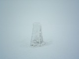
"A Bronze Age round cairn; a circular mound of stones 10.5m in diameter and up to 0.5m high. The surface of the mound has been partly disturbed by construction of a modern shelter using stones from the cairn." ADS.
This large cairn occupies the summit of selside Pike. We arrived there at the end of a long day on the fells around the head of Mardale. After many hours battling gale-force winds, mist, and horizontal rain, the weather eased off to heavy showers.
We sought sanctuary in the shelter that has sadly been made from the cairn. All around is nothing but grass, so the stones must have been carried up there.
It is a prominent site, with extensive views, including to the shap complex in the E, High Raise and Low Raise cairns to the NW, and the Four Stones Hill standing stones to the NE.
|
"A Bronze Age round cairn; a flat-topped oval mound of stones up to 0.8 high with maximum dimensions of 9m by 8m. There is a modern walkers' cairn on the northern edge of the cairn." ADH.
Just a few yards to the east of the route of the High Street R*man road, this cairn on the summit of High Raise is rarely visited. To the ENE the grassy ridge descends to the Bronze Age cairn on Low Raise.
The High Raise cairn is set on a rocky outcrop on a grassy ridge, the outcrops providing the building materials. On the E side a shelter has been constructed by wind-beaten travellers on the fells.
I've been here many times, and it always feels a special place of tranquility, even in times of storm, of which there are many.
|
"Remains of a cairn on the summit of Low Raise. 9.0m in diameter and 1.0m high." According to ADS.
I've been on High Raise more times than I'd care to mention for fear of ridicule. I've only been on the ridge down over Low Raise once. I knew about the cairn, but was still surprised to find it in a place where there was nothing but grass. No outcrops, no rock beneath the immediate few feet of surface, just peat.
This is a lonely place, make no mistake, just a faint trace of flattened grass to show that others had trodden there once or twice. Go there when the mists are swirling over the hills, as I did, when it seems that you'll never see more than a few feet of sodden fellside for the rest of the day. The cairn looms out of the mist like a great leviathan out of the depths. It looks like there is a quarry a few feet to the west, but seems too shallow to have excavated that much rock, and anyway, it's all far too rounded and regular.
This is a huge cairn for the area. Even on the surrounding rocky peaks the modern summit cairns are small. High Raise is an exception, and there lies another site.
Descending down to the Iron Age hillfort of Castle Crags, Haweswater is shown to its best, full length.
|
|
Obviously an old cairn, the stones being covered in very old lichen. The centre has been cleared to make a shelter. It is situated to the NNW of Burnmoor Tarn. Is this anything to do with the Burnmoor complex? It's marked on the map as an old cairn.
|
|
Reached here with Pie Eater, just after visiting Brats Hill. We're even more confused, due to the nearness of Brats Hill, plus the strange wall that looks like an enclosure. Also by the two circles. What went on here? Today all was peaceful, and had a nice feeling. But I've been here when the clouds are low on the fells, and a cold rain rakes across Burnmoor (one word, not two), and then the mystery of the place is all pervading, and a sense of doom pervades. Woooooo.
|
|
Reached this from Boot. After hitting the ridge, and not wanting to miss anything, we thought we knew best, me and Pie Eater, knowing these wild places of Cumbria like we do. A wearisome plod though deep tussocks saw us overlooking Brats Hill and White Moss. We descended to Brats Hill and found the path we should've stuck to if we had had any sense, but adventurous souls will always be adventurous souls, untethered by the constrictions of the modern world. Hmmmm. We noticed a few cairns, dug out(?) in the centre. This circle had a good view of White Moss. We were impressed by the number of large stones comprising the circle, all in surroundings of grass. They must've taken some dragging. We were also impressed, as always, by the bulk of Scafell, our next objective, rearing its head in omniprescent steepness to the north. A quiet place. Why here?
|
Lying between the Thorn Crag and Pike of Stickle stone axe factory sites, this site, one of many on Loft Crag, has been unearthed by the passage of feet on the popular Langdale Pikes. As well as many greenstone flakes and chips on the path and scree, there are also flakes and chips sticking out of the peat that has been eroded by walkers.
This is just part of a huge complex in Great Langdale.
|
Having read about this site, I knew where to look. Right on the brink of the drop into the depths of Dungeon Ghyll, these quarries appeared as hollows in the ground. Amongst the untouched natural rocks were greenstone blocks, flakes and chips, showing much evidence of stone working. The fact that I have only ever seen these in stone axe production areas highlights the authenticity.
The greenstone is a striking, clean colour, and the site is set amongst magnificent mountain scenery. Across the dark declevity of Dungeon Ghyll the craggy face of Harrison Stickle (another peak with axe factories) rises in steep, grey butresses, soaring high above.
Over the edge, before the final plunge into Dungeon Ghyll, there is another short slope, full of scree, and documented as containing more evidence of stone axe production, but I didn't visit that, as I was speeding towards Loft Crag and, finally, the Pike of Stickle stone axe factory.
There's always next time
|
The other day I decided to say sod it and go down the Pike of Stickle scree. We're not really supposed to do it, and I'll probably be criticised for it, but never mind. I trod carefully, at least as carefully as you can on sliding rocks.
The journey was part of a longer day on the hills, and I also visited the Thorn Crag and Loft Crag stone axe sites. I think all the Langdale stone axe sites should be split up into independant sites under the banner of "Langdale Axe Factory" on TMA. For instance, there's sites over on Bow Fell.
Anyhow, all the sites had much evidence of stone flakes and chips. Lovely greenstone, once the surface has been removed. The Pike of Stickle scree held an amazing amount of this evidence. It has to be seen to be believed.
The man-made cave had lots of smaller stone chips - evidence of a certain amount of basic finishing of the axes, or of working of the cave? The cave was aproximately 5 to 6 feet wide, 7 feet deep, and 7 feet high.
The descent to the valley was interesting to say the least.
|
What an unusual place. Iron Age, but not a fort? Doesn't seem to fit in with anything. Gives a feeling more of the Neolithic.
Any road up, it's worth a visit. The photos don't do justice to the fantastic position, or the panorama, especially down to the Bourne Valley and Salisbury.
The central area is vast, the banks and ditches deep and high. A huge number of man-hours must've been required in its construction.
It remains an enigma, but I feel we should be looking to the Neolithic for answers. Oh, and a few more excavations too, please.
|
What a place to get away from the mess and crowds of Stonehenge. Just to sit here and think, knowing someone of great importance was buried here. What ceremonies took place on this spot all those years ago?
There is a feeling of great open space, both on ground and in sky. The burial mounds stretch away in most directions, and the wind seems to whisper the secrets of the past as it sighs through the grasses.
A place for solitary contemplation, with a great feeling of the deep past.
|
Cracking views from the top of this hill. It did leave me wondering why the Iron Age fort wasn't built on the site of the Neolithic causewayed enclosure. Reverence for long-distant ancestors, or was it just that they required a greater area?
It was interesting to see the continuation of use of the causewayed enclosure from the Neolithic into the Bronze age, with the number of round barrows on the top, near the edge for visibility from the valley. One in particular was quite high. I also noticed that at the westermost point of the hill, the edge containing a few round barrows, has started collapsing, into what looks like an old quarry site. Did any of the barrows fall in?
The Bronze Age cross dyke seems to separate what was later the Iron Age "side" of the hill from the Neolithic/Bronze Age "side".
Pick a sunny day and you definitely won't have the place to yourself.
A word of warning:-
Don't park in the parking area halfway up the track, as it's a bit isolated, and you might get your window put through, like we did. We had loads of cds in the car, but they didn't take anything - either they were after credit cards, or our taste in music isn't up to much.
|
Walked from Hartsop to Beckstones, on my way to the hills, and called in to see the rock art. Arrived at the farm at the same time as a National Trust Landrover, with two people with enviable jobs within.
The first chap out was very helpful and enthusiastic, and was more than happy for me to go into the field enclosure (off the right of way) to see the rock art. He even knew it was prehistoric. "It's up theer, lad", he said, "supporsed t'be pre'istoric." I replied with "Ovver theer, up on th'mound?" To which he said "Aye, lad, it's on top o' that theer, jus' gerrup an' it's a few bits o' dimples in t' rock."
My heart sank - "...a few bits o' dimples in t' rock." And it was just that.
It's a small site to say the least, with cup-marks that were a little underwhelming, to me. No wonder it took so long to discover them.
Most are covered in moss, but is it ethical to clear the moss? I dug one or two out for photos.
About a quarter of a mile back there was a rock that someone had cleared some moss off, and that had, on first acquaintance a cup-mark. This, on closer inspection, looked more natural than man-made.
Having seen the Beckstones area, I am now even more confused as to what is natural and man-made. The big issue with cup-marks is the fact that with the Borrowdale Volcanic rocks there are so many natural cup-marks, that are attributed to volcanic gas bubbles. Having said that, the Beckstones cup-marks were fairly regular, but small.
The site is covered by trees, so photography is tricky, if your digital isn't set to what you thought it was, like mine.
So, apologies for the over-exposed photos, but they do give some sort of impression of what to expect. Thank goodness for the fact it rained hard last night, filling the cup-marks with water. The ones that I cleared the moss from don't show up much, but the puddles show up the others.
Further on, I looked over a garden wall, just below where the path from Pattrerdale ascends to Boredale Hause. Guess what? There's a rock slab in the garden with moss cleared off, and what looked to me to be cup-marks. I took a few photos from a distance, but will check t'internet to confirm my suspicions that this is another "Goldrill Beck" site, so the photos of that will have to wait.
|
Been past these rocks all my life, but the rock art stuff was only discovered fairly recently. It's all pecked stuff, and harder to see close up. Low, slanting sunlight shows it up best, when shadows are cast. Unfortunately, I've never had a camera with me then.
The photos I've posted were taken at 9:00am on 10th June 2005, when the sun was too high to provide decent shadow. Alright, it's my fault for having a bit too much vino collapso the night before, preventing me from getting up early enough.
As for the cup marks, I'm certain they're natural - gas bubbles when the rock formed. My reason for saying this? The rocks all over the fellsides around here exhibit the same characteristics. On the same day I found the same "cup marks" on the fellside directly above Copt Howe on many rocks, on the Blea Tarn road, on Silver How, Blea Rigg, Pavey Ark, Harrison Stickle, and back near the Old Dungeon Ghyll. Also, I know these features are common on Pike o' Blisco.
|
|
Eyes I dare not meet in dreams
In death's dream kingdom
These do not appear:
There, the eyes are
Sunlight on a broken column
There, is a tree swinging
And voices are
In the wind's singing
More distant and more solemn
Than a fading star.
T.S.Eliot "The Hollow Men"
|