|

|

|

|
 
|

|
I rang the National Trust today to ask if it might be possible to visit the chamber. I was told that the land around it is used by Chesire County Council for childrens' outdoor activities, and is therefor out of bounds for National Trust Visitors. The argument is that it's unsafe for members of the public to be given free access to an area where children are playing!
I gather that it doesn't matter whether schools are using the land at the time of a proposed visit or not. The agreement has been entered into between the National Trust and Chesire County Council, and it is apparently inflexible. What has the world come to?!
|
Reed Boat Sets off on Ocean Trip
From an article by Mark Pivac, published on the BBC News web site on 12th July 2007:A team of explorers has set sail from the US for Spain in a 12-metre-long (40ft) reed boat, hoping to spend about two months sailing across the Atlantic.
They are trying to prove that Stone Age people crossed the ocean thousands of years before Christopher Columbus in the 15th Century.
Aymara Indians in Bolivia, who still use reed boats, built the new vessel. Read the full article...
|
Visited 13/04/07: As Merrick says, this isn't an easy site to get to. Having looked at large scale maps since our visit I have a strong suspicion that one of the public footpaths that should pass close to the tomb is blocked by a fence.
The tomb stands just to the south of a rocky outcrop that's clearly visible from the road (see Moss' photo) but not marked on the Landranger. It's in the corner of a field, with gorse obscuring the view of it from the south.
We found our way to Ffyst Samson with some difficulty. We tried working from Merrick's directions, approaching from the south, but I wish I'd taken a better map with me. We ended up loosing the footpath, which I wasn't really comfortable about, but it really wasn't clear where it went. If I did it again I'd try an alternative route, approaching from the north east.
|
  
|
This site is described in the National Monument Record (accessible via Coflein and Historic Wales as a megalithic structure/summer house and is classified "Early Medieval?". The following text is given as the site description:A peculiar 'megalithic' structure set on a low hillock overlooking and to the W of Dolbadarn Castle.
It is primarily defined by two large orthostatic slabs set parallel to each other some 3m apart forming two sides of a square structure which has low pillars at each corner. Contiguous with the NE corner pillar is a larger 2m high squarish 'standing stone'. Numerous other blocks lie scattered about and the whole area is raised some 0.5m above the surrounding hillside. The eight figure grid reference for the site is SH58455977, and the National Primary Record Number (NPRN) is 300841.
|
Early Man 'Couldn't Stomach Milk'
From an article published on the BBC News web site on 27th February 2007:A drink of milk was off the menu for Europeans until only a few thousand years ago, say researchers from London.
Analysis of Neolithic remains, in Proceedings of the National Academy of Sciences, suggests no European adults could digest the drink at that time. Read the full article...
|
The word 'wraig' is mutated from 'gwraig', which means woman or wife.
The cairn to the north is a ring cairn, and it's labelled Carn Saith-Wraig on the old Ordnance Survey maps. The cairn to the south is a badly damaged round cairn, and it is unlabelled on the maps. On the National Monument Record it carries name Saith-Wraig, Round Cairn but I suspect this is by association with its neighbour.
The reason I mention all this is that you can't have the name 'Carn Saith-Wraig' for more than one cairn. The word 'carn' means cairn, not cairns. The plural is 'Carneddau', so if both sites shared the name they would collectively be called 'Carneddau Saith-Wraig'... I think.
|
Hobbit Cave Digs Set to Restart
From an article published on the BBC News web site on 25th January 2007:Archaeologists who found the remains of human "Hobbits" have permission to restart excavations at the cave where the specimens were found.
Indonesian officials have blocked access to the cave since 2005, following a dispute over the bones.
But Professor Richard Roberts, a member of the team that found the specimens, told BBC News the political hurdles had now been overcome. Read the full article...
|

Clues found for Early Europeans
From an article published on the BBC News web site on 12th January 2007:A genetic breakthrough could help clear up some long-standing mysteries surrounding our closest evolutionary relatives: the Neanderthals.
Scientists have reconstructed a chunk of DNA from the genome of a Neanderthal man who lived 38,000 years ago.
The genetic information they extracted from a thigh bone has allowed them to identify more than a million building blocks of Neanderthal DNA so far. Read the full article...
|
A web site about the excavation of Castell Henllys.
|
Neanderthal DNA secrets unlocked
From an article by Paul Rincon, published on the BBC News web site on 15th November 2006:A genetic breakthrough could help clear up some long-standing mysteries surrounding our closest evolutionary relatives: the Neanderthals.
Scientists have reconstructed a chunk of DNA from the genome of a Neanderthal man who lived 38,000 years ago.
The genetic information they extracted from a thigh bone has allowed them to identify more than a million building blocks of Neanderthal DNA so far. Read the full article...
|
A description from Coflein implies that Llech Ciste is interpretted, not as a stone row, but as a standing stone with other (suspect?) stones around it: A white quartz stone, 2.8m long by 1.0m wide by 0.8m thick, now semi-recumbent, having other stones, or boulders, associated with it. The site is no longer considered to represent the remains of a burial chamber. The name Llech Ciste implies a single stone, the word 'llech' being singular. Presumably the word 'ciste' is to do with the site being interpretted as a burial chamber.
The eight figure grid reference for the site is SN51422832, and the National Primary Record Number (NPRN) is 303977.
|
Visited 24th April 2005: I found it tricky to park on the A4120, then a bit scary walking the boys along the road. There's not a lot of traffic, but nobody is really expecting pedestrians.
The fort itself is extremely small, only really big enough to contain one family. It's the hillfort equivalent of a farmstead, built on a small promontory above the Rheidol valley. There are one or two hut platforms visible within the defences, but they're too subtle to photograph.
The remaining defences are pretty meagre, and unfortunately the strategic position of the fort isn't as obvious as it might be because of the surrounding trees. It's still a beautiful place to visit on a fine day.
Although I wasn't aware of it during my visit, there is permissive public access to Pen-y-Felin Wynt (hats off to the land owner!). If you want to see the approved route, visit the Countryside Access in Wales web site.
|
 
|

|
  
|
This page accompanies an article entitled The Stone Age tombs of south-east Wales by Steve Burrow, but I'm including it here because it contains a photograph of the bowl found at Ty Isaf.
|
This page accompanies an article entitled The Stone Age tombs of south-east Wales by Steve Burrow. I'm including it here because it contains an, "imaginative reconstruction of a burial ceremony at Tinkinswood".
|
How modern were European Neandertals?
Extracts from an article published by Bristol University on 25th August 2006:Neandertals were much more like modern humans than had been previously thought, according to a re-examination of finds from one of the most famous palaeolithic sites in Europe by Bristol University archaeologist, Professor Joao Zilhao, and his French colleagues.
Professor Zilhao has been able to show that sophisticated artefacts such as decorated bone points and personal ornaments found in the Châtelperronian culture of France and Spain were genuinely associated with Neandertals around 44,000 years ago, rather than acquired from modern humans who might have been living nearby. Read the full article...
|
The Mystery of China's Celtic Mummies
Extracts from an article published in the Independent on 29th August 2006:The discovery of European corpses thousands of miles away suggests a hitherto unknown connection between East and West in the Bronze Age.
Solid as a warrior of the Caledonii tribe, the man's hair is reddish brown flecked with grey, framing high cheekbones, a long nose, full lips and a ginger beard. When he lived three thousand years ago, he stood six feet tall, and was buried wearing a red twill tunic and tartan leggings. He looks like a Bronze Age European. In fact, he's every inch a Celt. Even his DNA says so.
But this is no early Celt from central Scotland. This is the mummified corpse of Cherchen Man, unearthed from the scorched sands of the Taklamakan Desert in the far-flung region of Xinjiang in western China, and now housed in a new museum in the provincial capital of Urumqi. Read the full article...
|
Bronze Age Canoe Stops Pipeline
From an article published on the BBC News web site on 24th August 2006:Archaeologists working on a gas pipeline near Milford Haven in Pembrokeshire have unearthed what they believe to be a 3,400-year-old canoe.
Work has stopped on a section of the pipeline near St Botolphs to allow the Bronze Age oak relic to be recovered.
It is the first such discovery in Wales and only 150 exist across Europe. Read the full article...
|
Hot Weather Shows Wales' History
From an item published on the BBC News web site on 8th August 2006:Hot weather has produced parched landscapes which have allowed experts to detect the outlines of some of Wales' earliest buildings... See the aerial photos, including an image of the newly discovered circular enclosure and barrow near Aberystwyth.
|
Iron Age Site Dig Open to Public
From an article published on the BBC News web site on 6th August 2006:Archaeologists excavating an Iron Age farmstead in west Wales say the site may have been home to "several families" as early as 200 BC.
After two weeks' digging at the 2,000-year-old plot, the team have uncovered the remains of a circular house together with pits and postholes.
Other buildings found last year appear to have been surrounded by two large protective ditches and banks.
The site, near Tremain, Ceredigion, is open to the public on Sunday 6 August. Read the full article...
|
This set of pages about the 'Prehistoric Village at Cladh Hallan' include a lot of detail about the site and a photograph of one of the Cladh Hallan 'mummies' (on page III).
|
The eight figure grid reference for this site is SH26647888 according to Coflein.
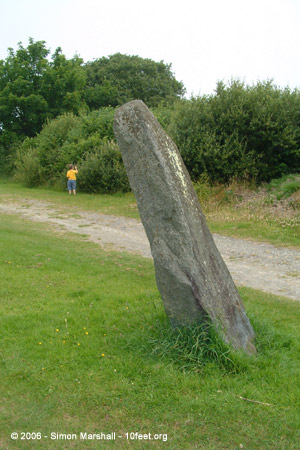
It's described as, "an undressed, erect monolith, 1.6m high by 1.4m by 1.4m". The National Primary Record Number (NPRN) is 302269 in case anyone wants to run a search for it.
|
A BBC radio programme by Chris Dearden including an interview with Steve Burrow, the archaeologist who rediscovered the Summer Solstice alignment. Note the extremely lame 'footsteps' sound effect at the start.
There's also a video clip on the BBC web site from a news item, first broadcast on Summer Solstice 2006. Both of these clips require Real Player.
|
Coflein lists the mysterious looking stones that lie near Tinkinswood, but doesn't go so far as to say anything definate:A variety of stones, to the E & SE of Tinkinswood Cairn (Nprn94510), that have variously been described as standing stones &/or chambered tombs...
Generally described as being non-natural features.
|
What's it like living in an Iron Age village? How did they keep warm and make tools? Did they live more rewarding lives? A re-created Iron Age village [at Cinderbury] allows visitors to stay and find out.
|
A note by J Wiles in the National Monument Record (NMR), available via Coflein, describes Maen Catwg as,A roughly rectangular prostrate stone, 2.6m by 1.7m and 0.6m thick. There are 33-50 cup-marks on the upper surface of the stone, which has been suggested to have been the capstone of a collapsed megalithic chamber. The NMR also describes a second cupmarked stone discovered in 1990 by T Driver (him again) in a pile of cleared boulders in a field near Maen Cattwg. The record states that, "the present status of the second carved stone is not known". I think that means they lost it.
The eight figure grid reference given for Maen Catwg is ST12709742 and the National Primary Record Number (NPRN) is 93097.
|
This webcam has Carmarthen in the forground and Merlin's Hill in the distance (on the horizon to the right of the church tower). The camera is very strangely positioned, so I'm not sure if it's been accidentally moved, or if this is the intended view.
|
A page by Roger Hulm, giving the name of the stone as 'Cefn Llech'. Hulm includes some good directions to the stone.
|
Another excellent little page by local man Roger Hulm. Hulm gives a translation of 'Maengwyngweddw' as, 'the stone of the white widow', and indicates that it's a possible allusion to the legend associated with Maen Serth.
|
A page by Roger Hulm, describing Maen Serth and the 12th century legend associated with it.
|
The Sarn-y-Bryn Caled timber circle was initially identified as a cropmark in grass field (there was nothing of the circle visible on the surface). The site consisted of a circular setting of 20 post pits with a diameter of about 17m, with some disturbance at the centre in the alluvial plain of the River Severn.
In 1990 the site was totally excavated by the Clwyd-Powys Archaeological Trust (CPAT) in advance of the construction of the Welshpool Relief Road.
|
An aerial photo of the Sarn-y-Bryn-Caled reconstruction.
|

About a third of the way down this page is a photograph of the reconstruction of the Sarn-y-Bryn-Caled timber circle in situ.
|
|
Described by the Gwynedd Archaeological Trust as a 'circular feature' (Reference: 3633), this site is by no means a definate prehistoric hut circle.
|
Photos of the cairn kerb (identified in this context as 'stone circle') as well as a photo of the nearby round cairn.
|
I live in a small Welsh seaside town on the west coast. As well as being well placed for visiting the local sites, it's relatively easy to get to sites in south Wales, north Wales and the borders.
If you'd like to use one of the photos I've posted on this site please contact the TMA Eds who'll pass the message on ([email protected]).
Some of my favourite prehistoric sites:
Avebury (England)
Calanais (Scotland)
Castlerigg (England)
Dolgamfa (Wales)
Gavrinis (France)
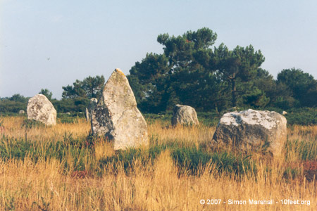
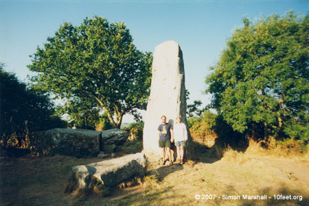
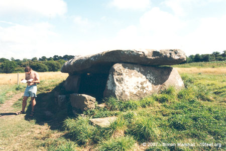
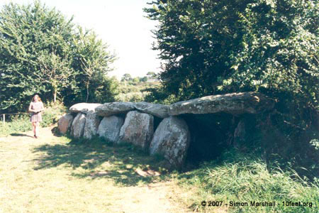
Kernic (France)
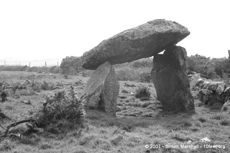
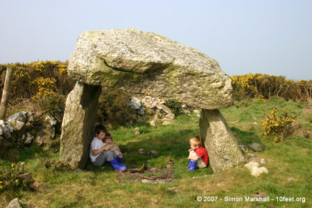
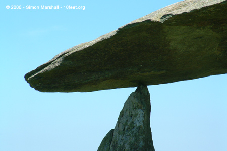
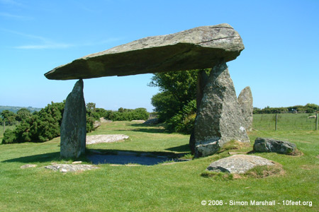
Pentre Ifan (Wales)
La Roche-aux-Fées (France)
Stones of Stennes (Scotland)
Wayland's Smithy (England)
Kammer x
|
|