Malta part 3 – urban sites
With my precious ticket for the hypogeum for an early afternoon tour, I decided to spend the day checking out the Tarxien cluster, in the suburb of Paola, only a short bus ride from Valletta.
The bus system on Malta is superb – routes covering just about the whole island and the fleet consists of mainly 1960s and 1970s vehicles. The basic fare is only €0.47 and you can travel from one tip of the island to the other for next to nothing. My favourite bus was:

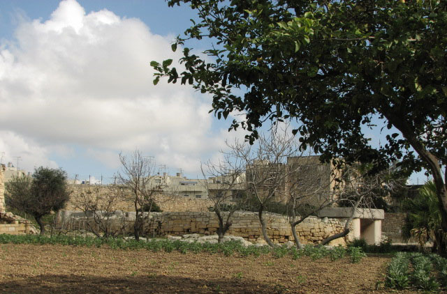
So, the bus to Paola where I got off at the church on the main square, and then headed left up the side street. A few blocks up, I turned down the handily named Triq it-Templi Neolithici to the Tarxien Temples.
The temples are open 9:00 – 17:00 and entry is €2.33 for adults; there's a small exhibition of items that have been removed from the site to preserve them and placed in the entranceway, and a selection of books and souvenirs to purchase. There are also public toilets. A new visitors' centre is expected on the plot to the east of the temples, and excavations have been carried out, but planning difficulties have held up the actual building work.
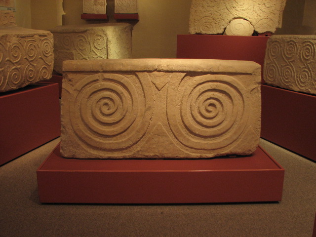
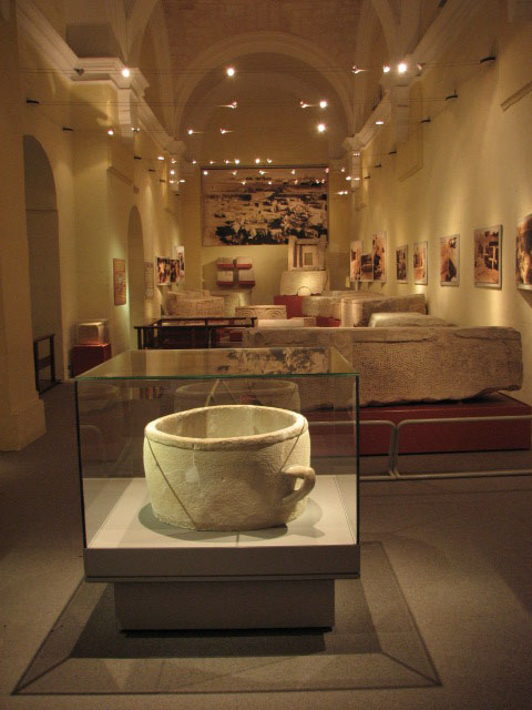
There are usually guided tours available in English several times a day – unfortunately the guide had called in sick the day I visited, so I was reliant on my notes and the offer by the staff to answer any questions I might have. Much of the carved stone from Tarxien was been moved to the National Museum of Archaeology in 1956, when restoration and reconstruction were also carried out, and the items on display are replicas – but this by no means detracts from the site.
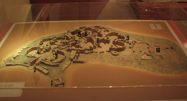
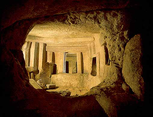
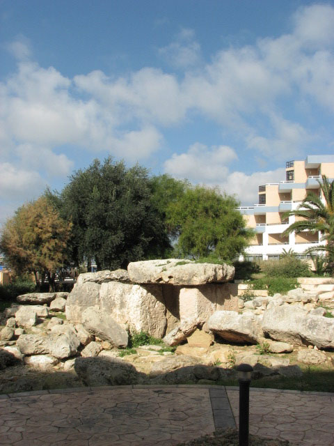
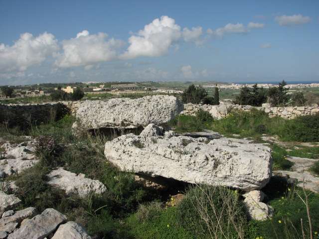
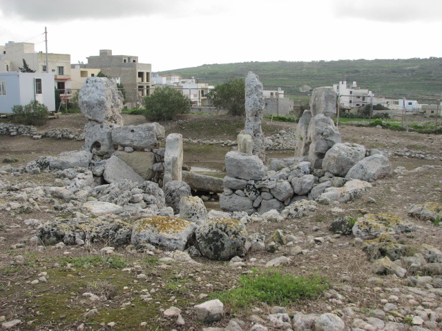
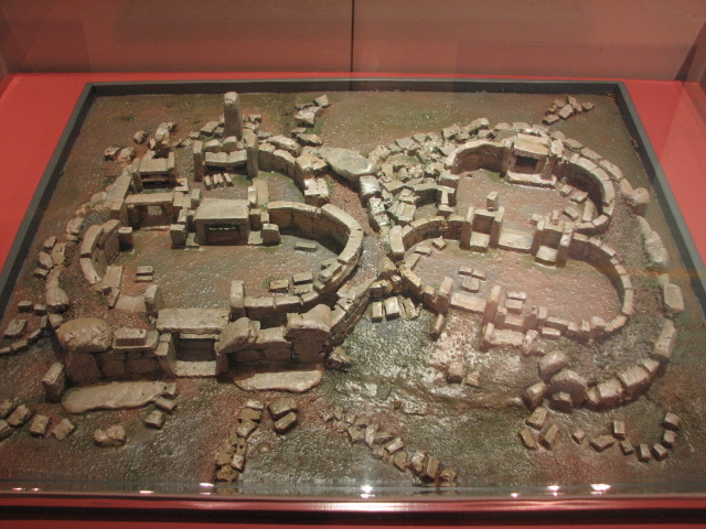
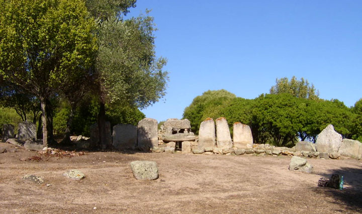
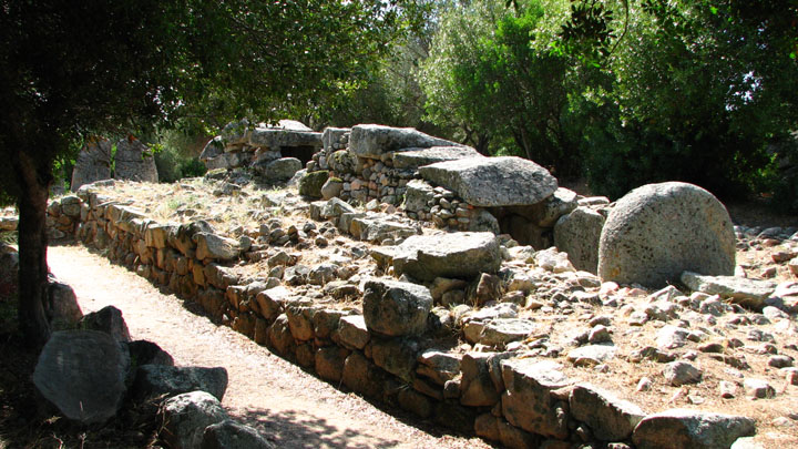
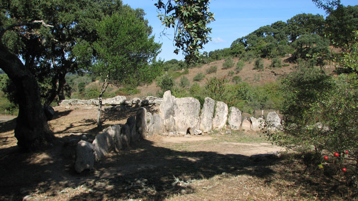
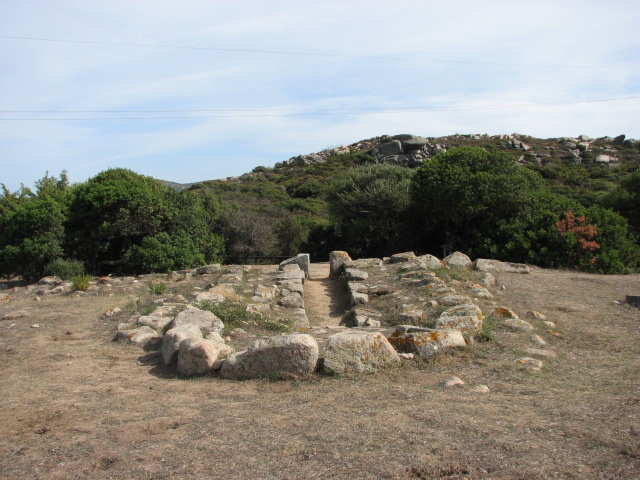
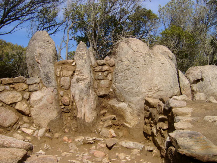
There are actually 4 temple structures on this site.
To the east, furthest away from the entrance, is the oldest, smallest, and least well preserved temple, from the Ggantija phase (3600 – 3000BCE). The stones are low lying, and only the western section of what is believed to have been a 5 apse temple survives. Area 10 on the model.
There are 3 main components - the south, central and east temples. Of these, south and east are older, from the early Tarxien phase 3000 - 2500 BCE, with the central temple having been built at a later date between these two.
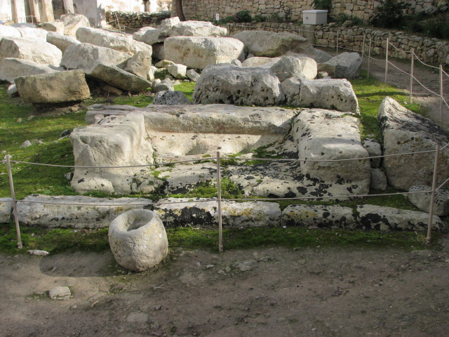
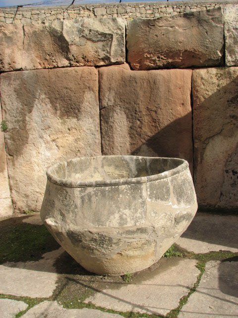
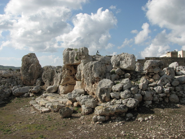
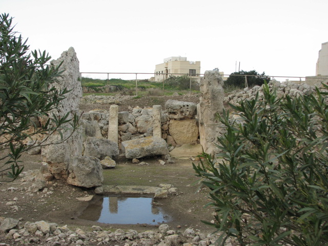
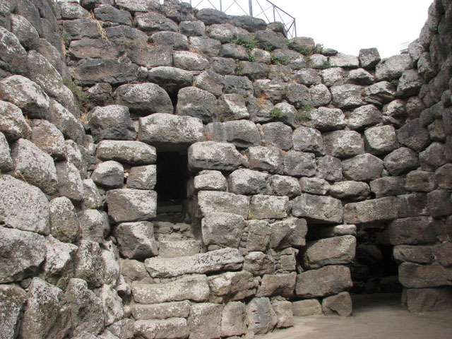
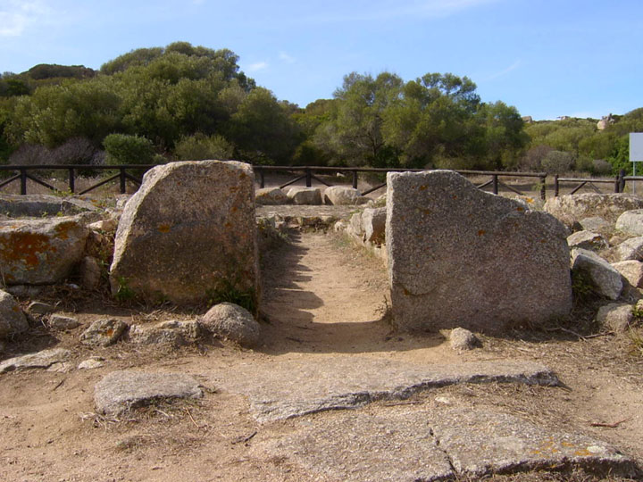
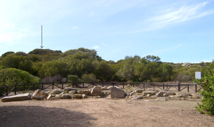
Taking a walk round from the main entrance to the site, there are numerous small boulders, possibly used to roll megaliths into place, scattered over the ground to the left, and then a well, before you face the trilithon entrance to the south temple. To the right here you can see the remains of a possible niche (ref 1), with libation holes and a stone bowl in front of it.
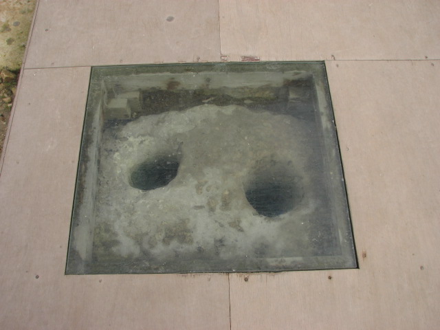
The path around the whole site has been improved and the tethering holes just outside the entrance to the south temple (ref 2) now have a perspex covering so you can view them through the path.
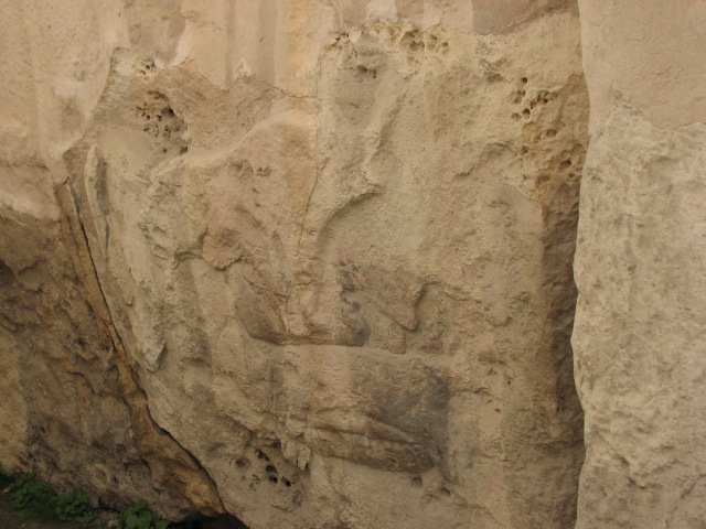
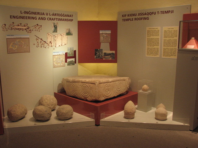
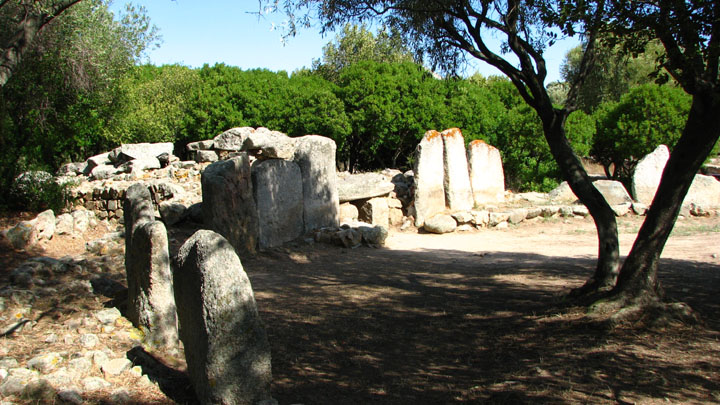
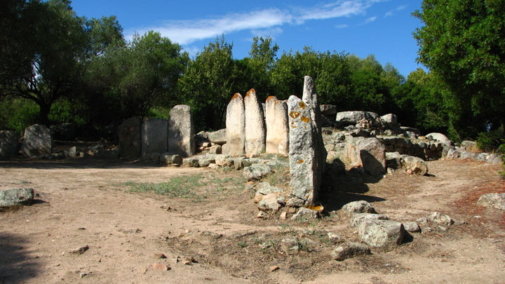
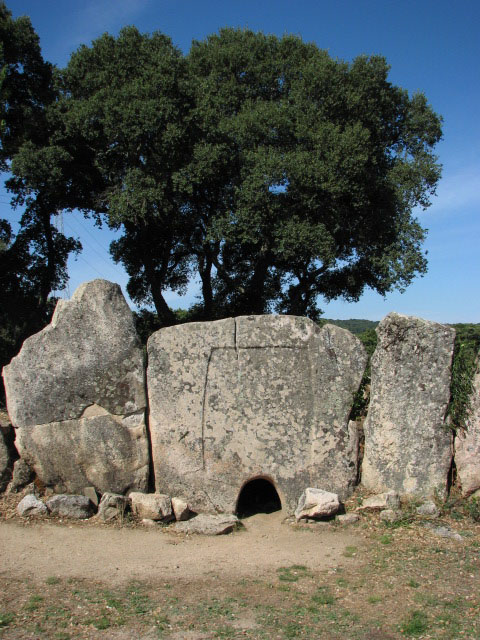
The main doorway has been heavily restored with rubble covered concrete; the first apse to the right (ref 3) has the huge statue of a skirted women and the altar with plug stone which contained animal bones and horns, and flint knives. To the left (ref 4) are many spiral carved stones and those decorated with animal friezes; the Mariners' Stones which stood here have now been moved into the entrance building for protection - they show ship graffiti but the debate is still out on whether this is late Neolithic (believed by Diane Wooler who studied them in 1957 and supported by T Zammit's notes) or from the Bronze Age (Evans, Trump and various others). A model found in 4 pieces in the northern most room of this temple lead Carlo Ceschi to draw a possible facade for the temple in 1936 (see links).
Moving through to the central temple, there's a huge stone bowl in area 5 and the walls here show fire damage. The oculus stone was originally in area 6, guarding the entrance to the 2nd pair of apses; there's a hearth in the centre of this area, and turning to the right, area 7, there's the bulls and sow chamber, now with a roof to protect the relief carvings.
Just before you leave the central temple, to the right, you can see a round boulder, used possibly for transportation or positioning, under one of the megaliths. Then there's a set of stairs, which may have led to an upper floor (area 8).
The east, and least decorated, temple, is thought to have been significantly altered for the building of the central temple, and was also reconstructed extensively by Zammit in 1919 - and suffered collapses as recently as 1999.
I had the site almost to myself for the best part of an hour, but then some more tourists appeared, and we started chatting. With only few info boards and no official guide that day, I found myself taking a small tour group round to point out the main features!
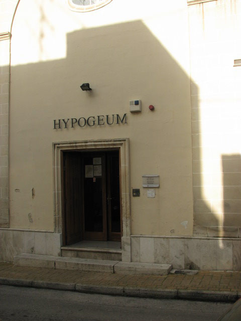
After a chat with the staff, I made my way to the Hypogeum.
If you plan to visit the Hypogeum, please check out availability long before you travel. I was fortunate to be there in very low season, so next day booking was possible, but at peak times it can be fully booked for over a month in advance. Tickets are €9.32 for adults - there's probably a child reduction but I wouldn't really recommend this place to youngsters unless they are really interested.
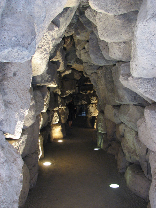
The building has numerous steps and low passages to negotiate, and is therefore unsuitable for the less mobile, or for anyone who suffers from claustrophobia or is afraid of the dark.
The group I joined were waiting in the entrance hall for our guide, and several times people came in without pre-booking - including a group of lads carrying a small Father Christmas who'd obviously had a couple at lunchtime - and were turned away. The entrance has comfy bench seats and toilets if needed.
There is absolutely no photography allowed and in fact you have to leave all your possessions in a locker - the guide has the key so everything is safe during the tour.
The first part is a visit to an exhibition of finds - most are of course in the National Museum of Archaeology in Valletta, but a few remain here, including a copy of the sleeping lady which you are encouraged to touch. Audio commentary is provided on hand held devices and is available in 5 languages. Then there's a film to watch about the discovery and excavation of the site, before you can enter the hypogeum itself.
Our guide - Joanne - offered as the whole group was English speaking, to dispense with the hand helds and do it "properly" for us - and happily the group accepted her offer.
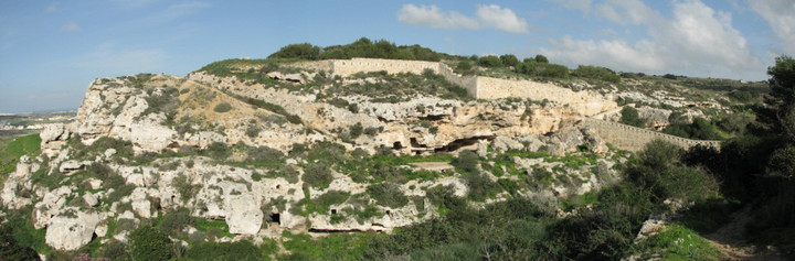
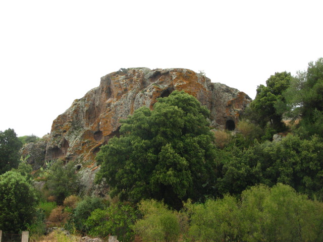
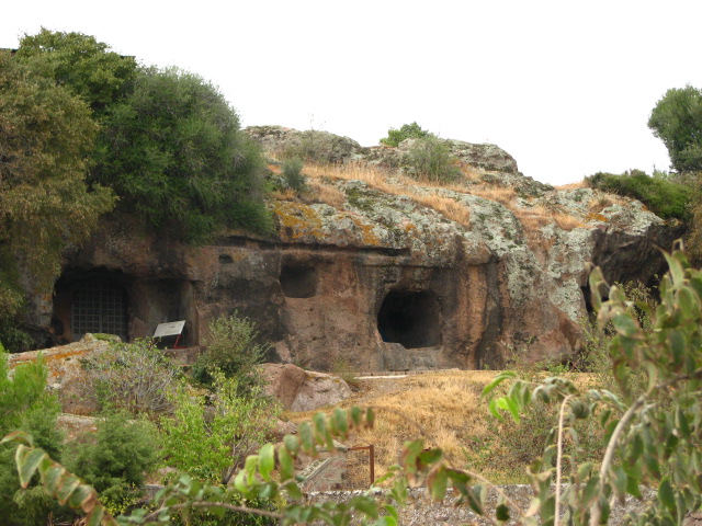
The area around Paola experinced massive development in the late 1800s to house dock workers, and the discovery of the hypogeum was reported to the authorities in 1902, but, from the construction of foundations and supports for the new builds, must have been known about for years before. In fact, the area around Hal Saflieni had an ancient name meaning "of the caves", so the site may have been known about long before that.
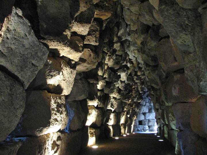
The hypogeum was excavated by Fr. Magri initially, with the middle level being opened to the public in 1908, and then T Zammit worked on the upper level after the purchase of the houses built on top of the site (the houses being eventualy demolished in the 1990s). However, it was closed to the public in 1991 as the damage caused by high visitor numbers had been realised, and reopened on 7 July 2000 - with climate control and regulated light levels. The lighting in particular dictates the visitor experience - it's timed to go with the audio commentary and only the features being described are illuminated. So you have to keep up!
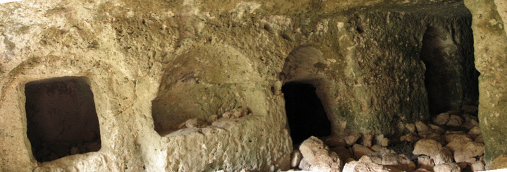
A door from the AV room leads to the upper level; here there is a massive entrance trilithon and side burial chambers. Zammit estimated, by counting the number of patellas amongst the ochre painted bones found, that there were around 7,000 bodies interred here. The path through to the middle level was closed for excavation work, so we all trooped back to the rear of the entrance lobby and down a dimly lit modern spiral staircase.
The middle level has the most interesting features whilst the lower level cannot be visited, just observed from above.
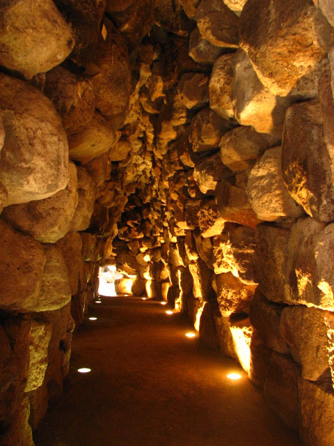
Our guide showed us a section of wall with pick holes in it; no metal tools have been found, so it's suggested that animal horns were used to create enough of a gap to insert a piece of wood, which when soaked with water would expand, forcing open the natural faults and fissures - with flint, obsidian and stone tools used to complete the rock quarrying. Then we moved through to the oracle chamber with its ochre spiral painted ceiling; the guide encouraged one of the party to speak into the oracle hole, but deemed his tone not deep enough for the full resonant effect.
We passed through another ochre painted chamber - this time with spirals within hexagons - to the trilithon looking down into the lower level and onwards to the "holy of holies". The lower level has 7 steps leading down to it - but then a 2m drop! There are side chambers at the level of the last step, and the group discussed whether these might have been accessed using a plank as a bridge between them.
The votive or "snake pit" adjacent to the second ochre painted room is thought to be the location where the Sleeping Lady was found. This small (only 12cm long) terracota statuette is the pride of the collection at the National Museum of Archaeology with its exceptional level of craftmanship; the curvaceous female figure is reclining on a couch and is often referred to as the sleeping goddess of fertility. As finds in the pit were discovered whole rather than broken, we discussed the possibility that the pit had been filled with water or perhaps straw to prevent damage to items placed or even thrown in.
The "holy of holies" chamber has a facade that possibly mimics the roof structure of Maltese temples, and has a side chamber of it, a niche (possibly for a statue) and libation holes. This chamber would have significant amounts of natural light from a shaft which runs right down through the hypogeum around the summer solstice.
Then we retraced our steps to look at the main hall, with its trilithon windows through to niches and smaller chambers beyond, and to the holy of holies. The chamber was originally painted with red ochre and some of the pigment is still visible.
Then round past the area where builders confessed to breaking through in 1902, with arches to support the houses above visible, and back to the spiral staircase up and out as the light faded behind us.
A fascinating place! I would have loved to have spent more time in each part, but the light levels are strictly controlled, and as I mentioned, timed to coincide with the audio tour, so it wasn't an option.
  |
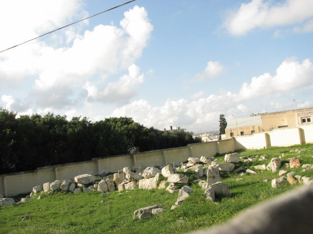
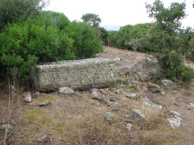
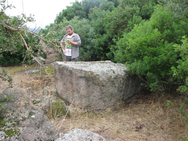
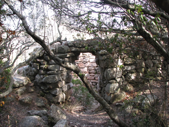
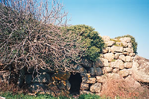
The Tarxien cluster consists of these two sites, plus Kordin I, Kordin II and, you guessed it, Kordin III. The first two were destroyed by WWII bombing and modern development, so I headed for number 3.
This site is not open to the public and is enclosed behind a high brick wall. However, it's only a few minutes walk from the Hal Saflieni Hypogeum and the Tarxien temples, so it seemed rude not to try to visit.
From the main square where the buses stop, head north north east along a road that bends to the right, until you reach a roundabout. Follow the footpath round to the first exit and cross the road immediately opposite church with a huge purple cross to its left.
There are signs to the temple but ignore these and go up the steps towards the church and in front of it, turn to your left. There's a gate in the wall facing you, and the wall that runs from here down the the building adjoining the church hides the temple.
The site is under the care of Wirt Artna and is open by appointment. I didn't have one, so had to content myself with standing on tip toes to balance my camera on the wall, and then walked round the block to find the back gate (which is beyond another gate, which fortunately was opened for me - sadly that gate keeper didn't have the set of keys to let me into the temple itself).
Excavations were carried out here in 1909 (Ashby and Peet) and a further survey in 1971 (Evans). There is a curved facade which is paved, and from the front of the structure, the upright megaliths left of centre lead through to the corridor of the trefoil building to the apses of the temple. Noteable features are to the left - niches in the wall, and the stone quern (sometimes described as a dugout canoe) across the threshold to one of the rooms. To the north, and visible on my photo taken from the back gate, is another structure, not at all well preserved, but thought to be another trefoil temple.
 |
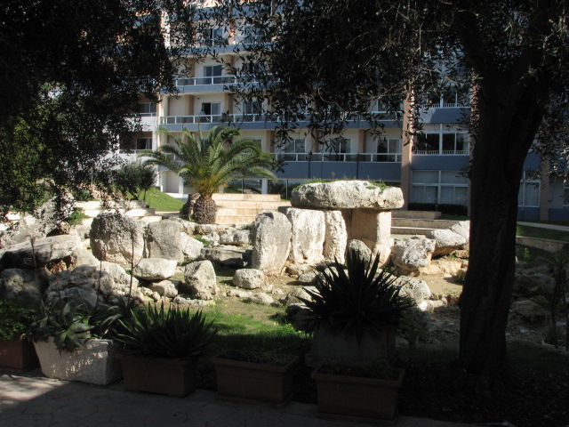
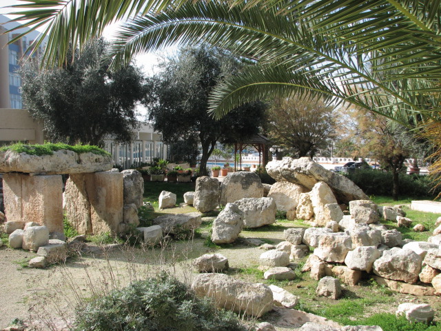
The trip concluded with a little liquid refreshment in Valletta, and a couple of days later I caught a bus north to visit what would be the final temple of my holiday.
The hotel entrance is directly opposite the bus terminus in Bugibba - cross the road, avoiding the timeshare touts, and head for the tennis courts. From the hotel lobby, head to the rear left (coffee bar) and take the first door to the outside. Go to your right - and the temple is half surrounded by a 1970s accommodation block for the hotel.
An information board proclaims:
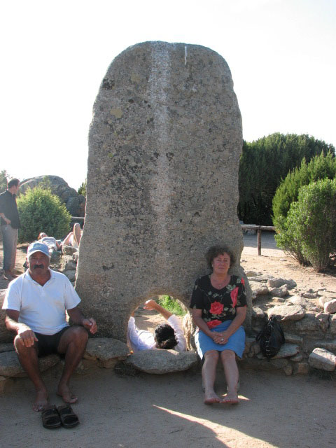
Bugibba Temple, which is preserved in the grounds of the hotel, belongs to the same category of prehistoric monuments as Tarxien and Hagar Qim in Malta, and Ggantija in Gozo. These imposing sanctuaries, erected for the worship of a deity which has so far defied a generally acceptable definition, constitute the oustanding achievement of the Maltese Copper Age, its Megalithic architecture. Their development lasted more than a thousand years and spanned almost the whole of the third millennium before Christ.
The features which have survived here are the main entrance roofed over by a single block of stone weighing several tons, some of the upright blocks forming the left front wall, the semi-circular chamber inside the entrance to the left and a thick rubble wall the incongriguity of which speaks for its Bronze Age date when the temple had long fallen into disuse. Two exceptional blocks, now to be seen at the National Museum of Archaeology in Vallette were decorated with relief carvings of spirals, and aptly enough for a temple so near the coast, stylised fishes.
"preserved" - not sure that's the word I would choose. Random wiring, half destroyed and totally unsafe no doubt, for nocturnal illuminations, fastened to the bottom of the megaliths, and general detritus from hotel guests hiding under boulders .... at least the carvings have been removed and saved.
Such a contrast between Bugibba and the first temple I visited, Tal-Qadi. No prizes for guessing which one I prefer!
And then it was time to pack and head home.
A few "thank you"s to people who made my solo holiday much more enjoyable than it might otherwise have been:
- the Heritage Malta staff - at Tarxien, the Hypoguem and the museum, and Sharon Sultana who's been answering my email queries almost as soon as I've sent them
- the staff of my hotel and the pub in Valletta, and the new friends met
- the very lovely Harry who was my gin and dinner companion most evenings. We were probably the only two under-40s in the whole resort!
I'm already plotting and planning another trip - with Beardy this time - here for next year - with lots of reading to do on the solar alignments of several of the Maltese temples, a topic I've barely mentioned.
|
Malta Day Trip
After torrential rain over night, it was with some trepidation that I drew back my hotel room curtains on the day I'd booked a hire car - and gazed out over the city and a glorious rainbow greeted me. Going to be a good day then!
Heading north from my base in Sliema, I got lost looking for a petrol station, but eventually found one, and the main road, and headed up the coast with a plan to see if I could find the dolmens at Ta' Hammud but when I saw the limestone outcrop at the turning (about 1km north of the water park, signposted Naxxar), and without an exact location to head for, or my GPS, I decided to continue on towards Bugibba and maybe come back later if time allowed.
I wasn't planning to head into any urban areas, leaving the temple at Bugibba for a bus trip later in the week, instead I was heading for Tal-Qadi. In TME, the introduction to Malta says that only the stone remains, but I'd found other references to the temple itself online, and despite it being marked in two different places on my map (pub Berndston, scale 1:45 000, cost just over 2 euros from a stationers by the ferries in Sliema and widely available) I figured I could find it.
I knew I had to turn south before Bugibba and Qwara, so did so, on a road signposted to Naxxar - but soon worked out I'd turned too early. So pulled one of the many u turns of the day and headed back to the junction and along to the next main turn. I reached the village of Bur Marrad and realised I still wasn't on the right road (normally Beardy navigates, and it's a lot easier him in charge of directions, rather than looking at a map and research notes spread out on the passenger seat) so headed down a side street to the left. A very bumpy and very flooded side street, which went past a poultry factory and a boat yard, and came out back on the first road I'd turned down. Bugger!
Sure enough, the flooded track between the two turnings I'd already tried was the one, and it took me through yet more standing water and round potholes galore, past a tiny church, and taking the left fork, I pulled up just after the poly tunnels of a nursery - Plant Supplier Ltd - and checked my notes. Getting out of the car with a sheaf of paper and a camera, a local man approached me and asked if I needed anything - and pointed me back a handful of yards to the path up to the temple.
In the north east of Malta, the easiest way to find this temple is to follow signs near Bugibba and Bur Marrad and Naxxar to Plant Supplier Ltd as it's directly opposite.
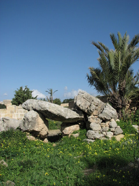
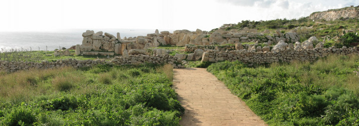
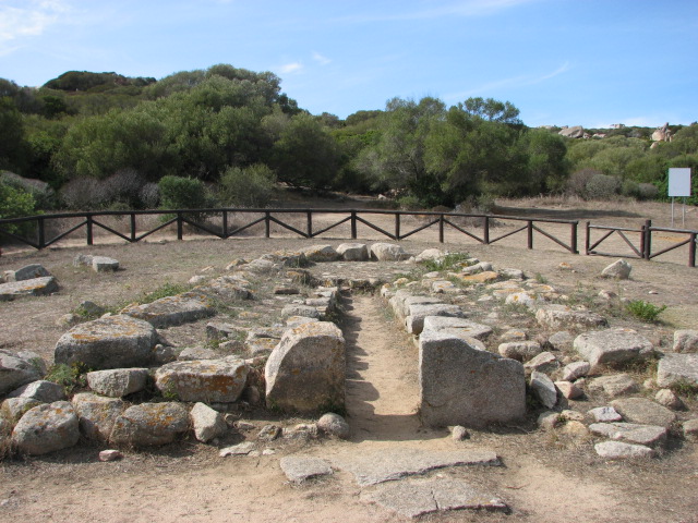
The temple is not signposted or labelled, and is supposedly closed, but there was nothing blocking my way, so I walked up the track beside a modern building.
To the left were huge stone blocks, and then an archway - described as dolmen-like elsewhere - which I used to enter the temple. Being winter, the ground was covered with a plant like giant clover, and I used the paved blocks to pick my way cautiously across the soggy site. It was hard to make out the four apse plan (excavations here in 1927 by Zammit) but the (more modern?) steps at the original entrance to the temple stood out.
It's thought to be the only temple orientated east-west on the island and its most precious find was a decorated limestone slab - see link - which is on display at the National Museum of Archaeology though I missed it - pah!
  |
Wow! A temple all to myself to start the day! After a teasing text home, I headed south and soon negotiated the sharp hairpin bends north of Naxxar and stopped to check out a cart rut site. Not a site type that particularly inspires me, but seeing as I was passing .....
The winter greenery made it difficult to work out this site, but it must look fantastic in the summer (I bought "Malta before History" - Miranda publishers - expensive but exquisite - see page 394 - as my holiday souvenir) with ruts running straight across flat ground and bending round and down the slope.
There's extensive quarrying in the area - almost right up to the edge of the ruts.
.... and then headed on to the west towards Mosta to find the dolmens of Wied Filep.
I guess I approached from the easy direction, as I pulled off the main road (Ghargur to Mosta) heading west from San Pawl tat-Targa Cart Ruts just before Mosta fort and with a group of houses to the left, and looked to the right and there was the walled enclosure!
Overlooking St Paul's Bay, dolmen A is the larger of the two with a capstone 3.6m x 1.7m supported on three (?) stones about 1.4m high; dolmen B is smaller, supported by the edge of the plateau on one side and low stones on the other - its capstone is about 3m long.
 |
Feeling proud of my achievements so far, I proceeded to get lost in Mosta, but eventually found the right road to head towards Mgarr and another temple.
This site is currently only open to the public on Tuesdays 09:30 - 11:00.
It's signposted but the easiest way to find it is to head west towards the dome of the church in Mgarr and watch out for a side street to the left about 200m before you reach it.
The site has a low wall but high railings surrounding it, and a security hut and portaloo - and a gate with a big padlock!
The site was excavated by Sir Themistocles Zamit over various periods from 1923 to 1929, and then restored in 1937 by his son, Charles.
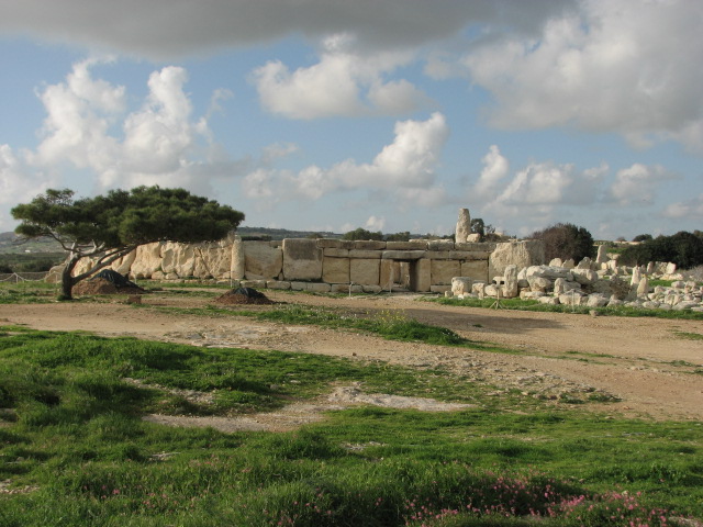
There are two buildings here - a main temple with a smaller one to the north.
The main building follows the usual trefoil pattern with apses arranged around a central room, and the floor of this central area is lower than those of the apse rooms. The main facade is concave, and there are 3 large steps from the forecourt through the restored trilithon into the temple.
The small temple has a similar if slightly more irregular shape, but without the impressive entrance stones.
  |
Then back a few miles to the village of Zebbieh.
This site is only open to the public on Tuesdays from 11:30 - 13:00 - so would tie in nicely with an earlier visit to Ta' Hagrat if you plan carefully.
The site was noted in 1914 by Themistocles Zammit but not excavated until 1937 by Captain Charles Zammit - with only preliminary work carried out then and further investigations put on hold by the outreak on WWII. A full survey was eventually conducted from 1961 (David Trump) and showed that despite the poor state of preservation, it was indeed a very important site.
There are two temples here - enclosed by a nasty wire fence with a guard portacabin inside but a blue tardis loo outside (cheers!) - and then to the east, behind a low wall, are the remains of two huts.
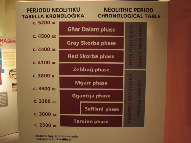
Skorba has infact given its name to two of the periods of Maltese prehistory - Grey Skorba (4500 - 4400 BCE) with its undecorated grey pottery and finds of hunting implements and obsidian and flint - and then Red Skorba (4400 - 4100 BCE) with its pottery covered with a red clay slip and highly polished; however finds from the site show its use for perhaps 2000 years.
The wire fence only really encloses the better preserved west temple, and cruelly cuts through the ground plan of the east temple, leaving the red skorba huts outside and almost hidden - I'm glad I rechecked my notes and found the huts as they revealed important finds (a group of figurines, pottery and goat skulls) and were suggested (by Trump) to be part of a shrine.
The west temple has a trefoil shape, with only really the back apse and one megalith at the entrance with any height. A noteable feature is a series of libation holes at the entrance - the flooded area when I was there. Libation holes may have been used for liquid offerings, but there's also some discussion that they were used as a tethering point for animals (for sacrifices).
Skorba is signposted from the road from Mosta/Mdina to Mgarr - watch out for the square to your left after the road climbs uphill as the temples are at the end of this, at the edge of the village.
Time to head south, and only a couple of miles south of Mgarr I pulled up at a tiny chapel with a glorious view to check the map (again!) as I'd noticed a few cart rut sites and tombs marked along the way - and miraculously was in just the right place.
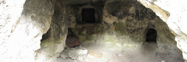
At Bingemma gap, along the Dwejra section of the Victoria Lines, there's a tiny chapel dedicated to Our Lady of Itria with a Punic tomb underneath it, but if you look to the right of the chapel, there's a path down to a network of rock cut tombs believed to date back to the Bronze Age but also reused in Punic times, by early Christians, and also as refuge for local farmers during WWII.
I've not as yet managed to find any evidence of the exact age of these tombs (the map clearly says prehistoric) but spent a very pleasant hour or so scrambling in and out of them in glorious sunshine.
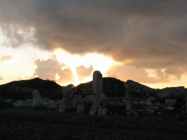
I decided against trying to find the temple at Kuncizzjoni (Qortin l-Imdawwar) or the bronze age village nearby, on private land and difficult to find, I'd been told, but continued on south, getting lost again round the outskirts of Rabat but eventually finding the road to Dingli with the intention of taking a look at Clapham Junction - but got lost again and before I knew it was a mile or so south of Siggiewi on very dodgy backroads and hence not far from the two most famous sites, Hagar Qim and Mnajdra.
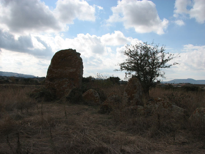
I knew I'd missed the dolmen at Misrah is-Sinjura and that the next two were closed to the public (see Malta news post) but decided to continue on anyway.
I pulled up at the almost empty car park, and a taxi pulled in behind me disgorging a young American couple "You do know it's closed" I said. She'd not been keen on the visit and the info didn't go down well. Oh dear!
I was only able to walk round the outside of these two temples, but highly recommend you take a look at Fitz's excellent blogs Hagar Qim and Mnajdra for great photos and details of the spectacular sites.
I wandered round the fencing, taking the path recommended by a friendly hunter I passed round the right of Mnajdra to get a view into the temples, past the occupied guard hut complete with dogs, and right round to the amazing view of Filfa with the sun on the ocean from behind the clouds - what a magical place! The walk back up towards Hagar Qim, I was accosted by a local man out walking who recommended a small beach and cave further along the path (not the Blue Grotto, somewhere much quieter) but it wasn't swimming weather yet - in fact he expressed considerable concern that I had goose bumps from the chilly afternoon breeze, and that I should put on more clothes to avoid getting ill - bless him!
Even though these sites are closed, if you find yourself on Malta in the next few months, still visit - if you can bear to be so near yet so far. The area is stunning and I'm sure the picnicing and swimming spot nearby would be a winner.
From here, I headed towards Zurrieq, and promptly got lost yet again. A few u-turns and right-round-the-roundabout manoeuvres I ended up on the road to Hal Far in search of Wied Znuber dolmen but passing the sad refugee camp on the disused airfield, I lost my concentration and bearings, and glee for the day's discoveries, and took yet another wrong turn. Before I knew it, I could see the ugly container port at Pretty Bay and headed to Birzebugga. By this time, you'll not be surprised to hear, the day was drawing on, but I knew I had to make one more stop - and caught a glimpse of a temple sign.
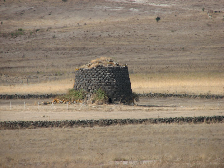
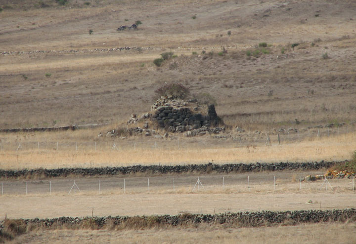
Borg in-Nadur is under the care of Heritage Malta and is not currently open to the public. As well as the temple, there's the remains of a bronze age settlement to the south west and the possible remains of a room to the south east.
The area immediately in front of the (unusually not concave) facade of the temple is being used for vegetable cultivation and there's a security hut, similar to those I'd seen at Ta' Hagrat and Skorba.
The site was noted possibly as early as 1536, but definitely from 1647, with excavations being carried out by Margaret Murray in 1920s.
It's hard to make out the site apart from its entrance megaliths but aerial photos do show a four apse structure to the south east of the main enclosure. There's a fair bit of rubble around, from excavations and local field clearance.
With the sun well and truly setting, and rush hour starting, I headed north then round the Valletta conurbation, through crazy traffic (I only took the wrong turn once, but to get back on the right route I twice had to cross 4 lanes of insanity!) and miraculously ended up home safe. Phew!
Just to point out, Malta is a very small island and I didn't check the mileage I'd done, but I used less than 10 euros worth of petrol on the day trip.
|
Malta January 2008
What a shame that the spa break I need was cheaper in Malta than the UK!
A few days of research revealed that some of the sites I wanted to visit were closed, or only open at very restricted times, or not open at all, but I decided to chance a week of oap-package-ville anyway.
The first stop was the Archaeological Museum in Valletta to see the finds from all over the islands, and find out more about the places I wanted to visit, and most importantly to book for the Hal Saflieni Hypogeum.
The museum is on the main street in Valletta, Triq Ir-Repubblika, it's identified by flags outside, and is only a few minutes walk from the crazy bus terminus. Open daily 09:00 - 19:00 (last admission 18:30) and costs 2.33 euros (seniors and students 1.16, children 0.58, 5 and under free). There are currently guided tours in English every day at 10:00 and 15:00 at no extra charge. There's a well stocked shop and visitor toilets. Officially there's no photography inside, but no one seemed to mind me taking pictures without flash.
I had arrived a little later than planned due to a long wait for a glorious 1960s Bedford bus and some crazy traffic, but tacked onto the 10am tour less than half way round and was very glad I did - a very well informed guide explained the temples and their finds with a fair amount of humour too.
The first part of the museum (nb only the ground floor is open - but seeing as it's this floor which covers the prehistory I wasn't bothered that the planned expansion upstairs and galleries on Phoenician and Roman culture, through 1800 CE, were still unfinished) explains the cronology of the period covered (5200 to 2500 BCE) and the possible construction techniques used, before moving on to look at most of the main sites in order and in detail, with fabulous scales models to see.
Some information about the finds:
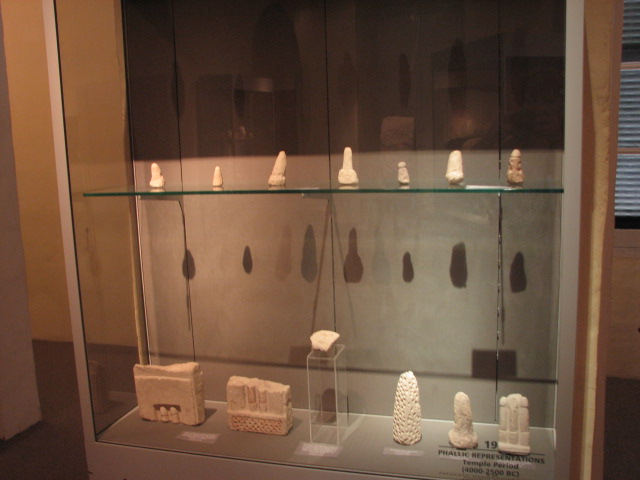
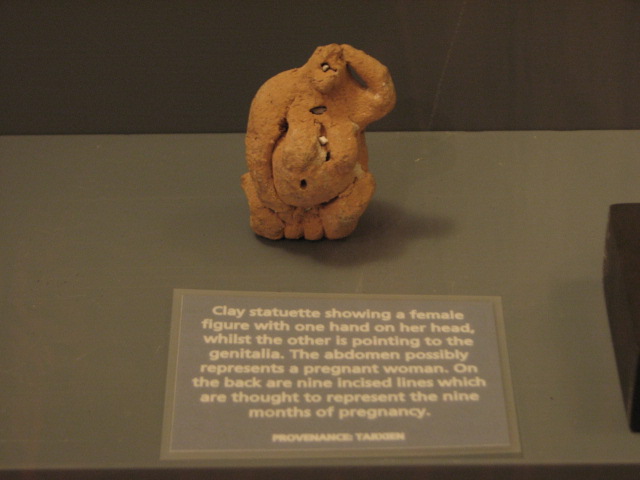
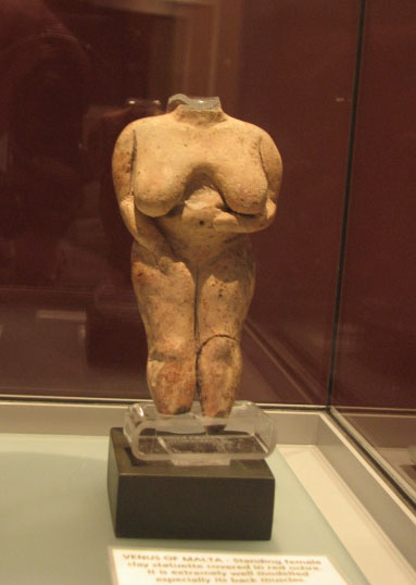
there are loads of headless bodies, with sockets where the neck should be, to insert a choice of heads (from Hagar Qim); a green stone cylinder with gold inlay (unique to the islands) and red stones inset (from Tarxien); a sherd with a solar wheel decoration (from Hagar Qim); the Venus of Malta; a clay statuettte of a pregnant woman and a whole display case of stone carved and clay phalluses (maybe the temple builders were indeed part of a fertility cult); and most importantly, the "Sleeping Lady" found at the Hal Saflieni Hypogeum.
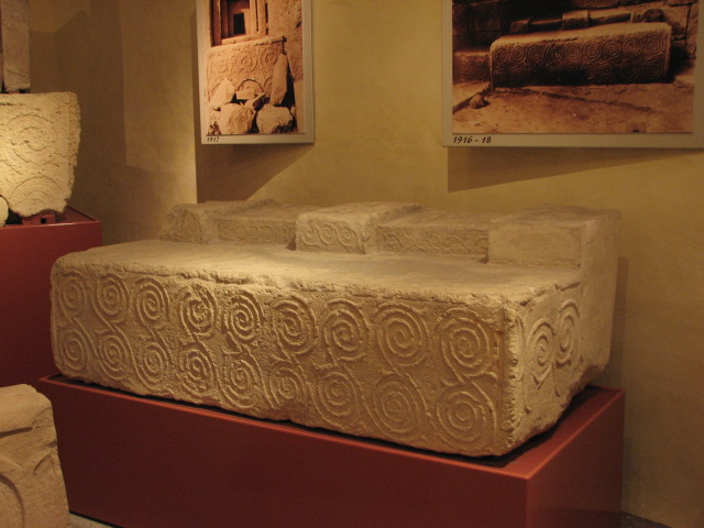
The largest room is devoted to the Tarxien temples, and has many of the original spiral carved stones, moved to the museum to prevent damage from weathering - replicas are now in situ there. Many of the stones are shown alongside photos of their excavation.
The museum building is the Auberge of Provence, and the guide explained its history with the Knights of St John in the 16th century.
An essential visit!
I stopped at the entrance desk to chat with the guide from earlier, and ask about some of the other sites I planned to visit. Two of the temples are only open on Tuesdays, Hagar Qim and Mnajdra are closed for conservation work, and a few of the dolmens I mentioned were unfamiliar to the staff - but they were very helpful, even phoning through to see about access to closed sites (available by appointment but a fee payable - maybe a good option if you are in a group) and after a lengthy browse in the bookshop and a long walk round the city bastions, I adjourned to The Pub to quench my thirst and plan a day trip.
|
Sardinia - Sassari circuit plus (it's the final part!)
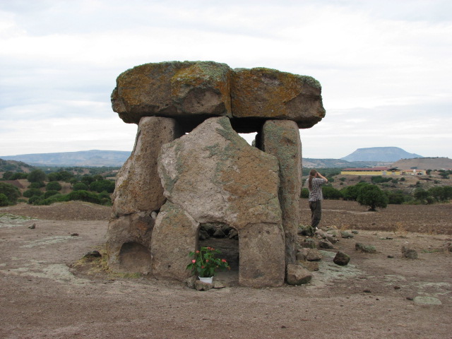
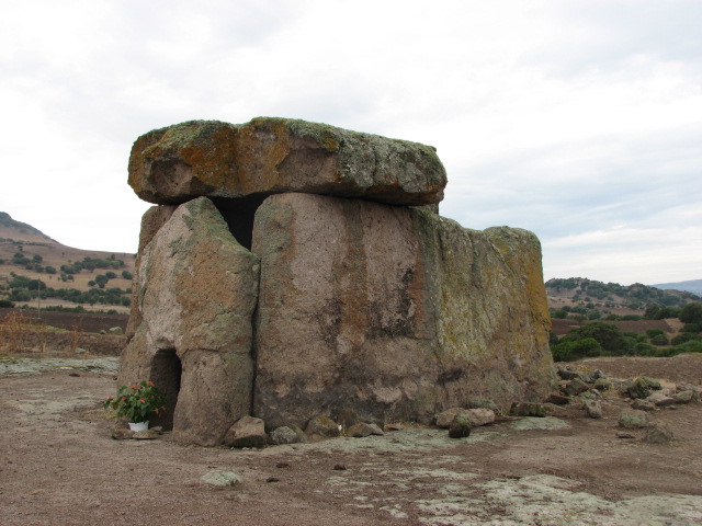
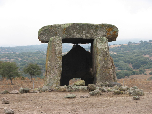
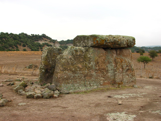
After a lazy Sunday on the beach and in the warm turquoise Mediterranean, a drizzling Monday morning dawned, and we managed to get up early enough for a full day out. After the fast road freakout, we decided to steer clear of the SS131 as much as possible and headed west from Olbia on the 199 instead - a reasonably good road but with some strange junctions - through an amazing volcanic landscape. We were aiming for the town of Mores - and just before that, our first stop of the day - to see the largest dolmen on the island.
1.4 km east of Mores, on the 128bis, turn south onto the SP47. After 6.3 km turn right, and then after another 3.15km turn right again past the farm to the dolmen. All turns are signposted!
Just before the final junction, we were held up for a while by, but then inched forward through, a flock of sheep and barking dogs, actually herding a few stragglers with the car when we turned to the farm.
The first gate is 730 metres further on - we drove through and parked, walking the last couple of hundred metres.
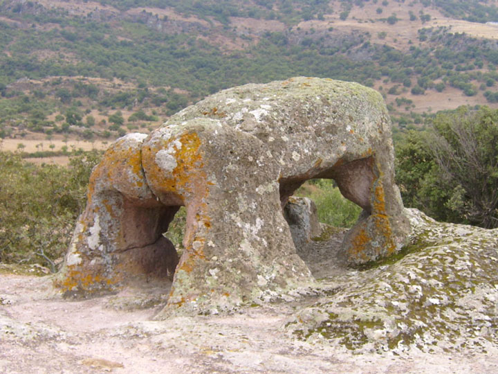
It's huge! My notes say 2.7 metres tall, 5 metres long, and the capstone used to be 6 metres by 3 metres by 60 cm, weighing in at 27 tonnes.
The rear wall is missing; the front has a small portal as though belonging to the stele of a tomba di gigante, and inside there's a niche carved into the side wall.
Whoever had visited the dolmens such as Ladas around the village or Luras had been here, or maybe it's a local custom, but yet again a potted plant had been left recently.
Free and open access - but watch out for livestock on the approach road!
The information board by the gate mentioned a menhir, so we wandered down the path - and realised we'd gone too far so headed onto the rocky outcrop on the right for a better view, and then stumbled on to where we wanted to be.
From the dolmen, follow the wide path away from the farm. There's a single tree, and then a clump of trees to the right - just before the clump, veer to the right (up a slope heading NNWish), and on the right after 50 metres, the menhir can be found fallen behind some bushes.
With the drizzle easing off and the sky starting to blue up nicely, we got back in the car. Turning out of the farm track, there was another car turning in and we got a cheery wave. The "perpetual percussion soundtrack of sheep's bells" (TME) was in evidence, and surely enough, a hundred metres or so along, we found ourselves facing the flock again, with the dogs even more keen to bark at us and not move the animals at all. We were sat pondering how long it would take to get past, when the car we'd seen a few minutes before pulled up behind us, and the guy got out, still grinning from ear to ear, and proceeded to usher the flock out of the way and wave us through and on our way.
"Multo grazie signore!"
We headed west, through Mores itself with a small diversion following signs to nuraghe and not finding them, and then further west to the other branch of the 131 (from Sassari to Cagliari) where we turned south intending to check out varies sites around Torralba - and missed the turn so kept going a bit further, and turned off at Bonorva (even though Macomer was only a tempting 18km beyond that) to visit our first domus de janus.
From Bonorva, follow the signs towards Bono (also signposted for the site) on the SP126 and then the SP43. About 6.5km from Bonorva take the right fork and proceed carefully - we hit the bottom of the hire car on a ridge and pothole combo and though fortunately nothing fell off, and no leakage occurred, it made some very nasty noises for the rest of the holiday and didn't do much for my nerves! - for another 2.5km. Park on the road by the big tree opposite the site.
Open 10:00 - 13:00 and 15:00 - 19:00 (all day in July and August, I think), entrance 3½ euros per person including guided tour of the main tomb - in Italian!
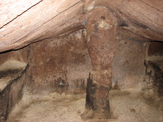
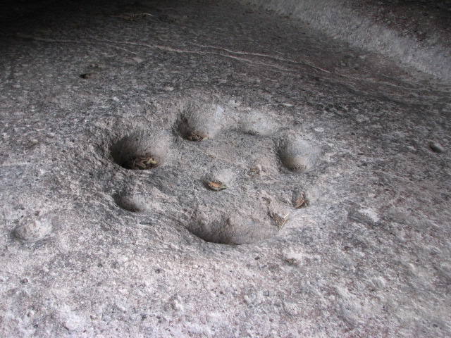
From the ticket hut, follow the path up the slope and double back on yourself past the steps and tombs to the "tomb of the head" which is locked when the site is closed. This tomb is deep and made up of several different rooms: the vestibule area has cists cut in the floor on the left and cupels the other side of a central rainwater channel. The two rooms behind each have two pillars and numerous side chambers, and on the ceiling you can see the original red paint, and later murals as the tomb was used through Roman times, and then used as a church, and was still in use in the Middle Ages. There are numerous friezes from its Christian period on the walls. There's also a light well, and the floor in the central chamber has been carved to collect the rainwater that this also lets in, probably used for baptisms.
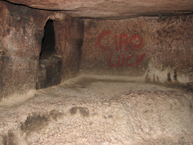
You are free to wander around the rest of the site - to the right is tomb VIII with its carved roof, meant to resemble the rafters of a hut, and right from there in tomb IX someone's added graffiti "Ciao Lucy" in red paint.
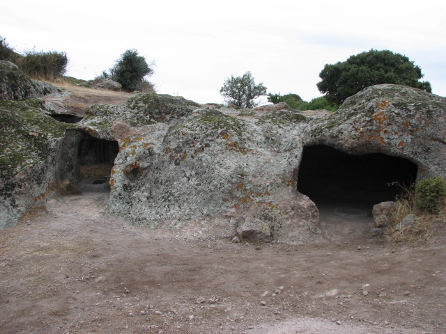
The steps to the right lead to a small gate, and then a rock cut path to the hilltop, where you find more tombs / dwellings cut into the rock, and the rock cut dolmen, described as being known locally as "the Elephant" in TME, but also listed as a Taurus in my research.
Retracing our steps towards Bonorva, we decided to continue with new site types, and hence turned up the steep hill after only about 4km to the village of Rebeccu in search of the Fonte Nuragica Su Lumarzu - signposted from the main road. I didn't have a grid reference, and our instructions were vague, and we couldn't see any of the promised arrow markings, so headed uphill just in case - and then back down again. By this point, it was lunchtime and the builders who'd been working on the village church had disappeared, so we gave up and headed towards Torralba and one of the sites that had stood out in my research:
If you only visit one nurahge, make it this one! Just take a look at its aerial view from Google ...
Signposted from Sant' Andrea Priu and south of Torralba, on the SP121, in the valley of the nuraghes - they are everywhere! We'd taken some binoculars and spotted the nuraghes of Fraigas, Oes, Bonzalzas, Mura Coloras and Cabu Abbas with little difficulty - all under 1.5km away. Fig 29 in Margaret Guido's book shows the distribution of nuraghe across the island - and here it's over 0.6 per square km. Crazy!
There's a fair bit of parking in the layby, a simple cafe, ticket booth (entrance fee 3 euros, ticket also valid for the Valle dei Nuraghi museum in Torralba) with information leaflets and an extra hut selling local produce of all kinds.
The site has been managed by La Pintadera Cooperative since 1992, when the town council assigned Santu Antine to them.
We stopped for a toastie and a drink, while talking to an older couple trying to persuade a small scared white kitten to drink the cup of milk they'd bought for it, and then went past the reconstructed round hut at the gate and to the southerly entrance.
There's a settlement surrounding the nuraghe and it's possible to make out maybe 10 huts, with some later Roman building too.
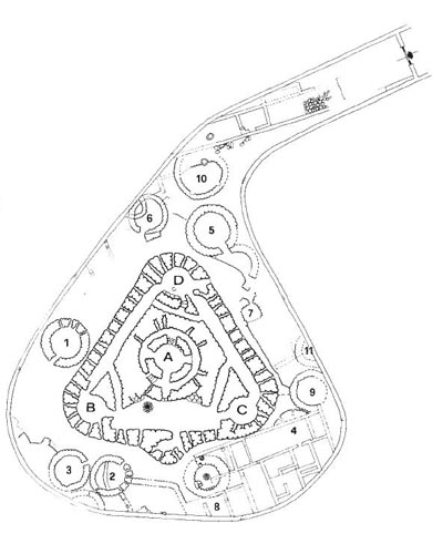
The nuraghe itself is built on a triangular plan out of basalt blocks. As you go in, there's a guard post or sentry box to the left - this area now houses the visitors' book - and then the courtyard. It might make more sense if you have a look at the plan .... but ....
The furthest left is the entrance to the west tower (B), then a passage which joins the passage which runs from the west to the north tower (D). There's a flight of stairs up to the second level with a well just in front of it, then an entrance to the central tower. The pattern repeats itself with another staircase, a passage to the passage that runs from D to C, and entrance to the east tower (C).
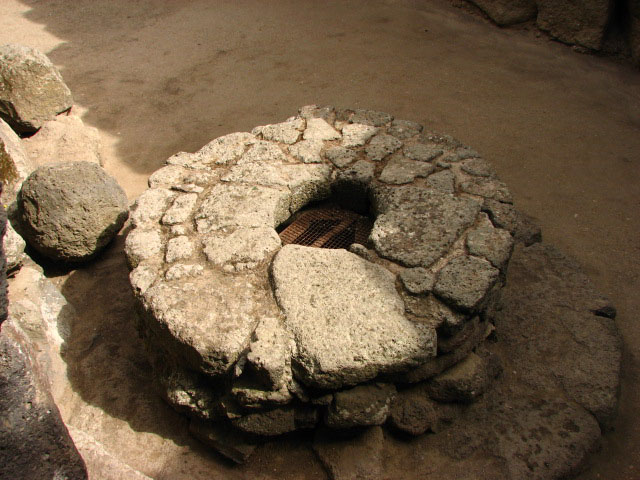
We checked out the ground level first of all, amazed at the illuminated corridors, and saw the second well in the north tower, which also has a secondary - now barred - entrance to the nuraghe. Then we took the left hand stairs which lead to a walkway round the perimeter wall and then back down the right hand stairs.
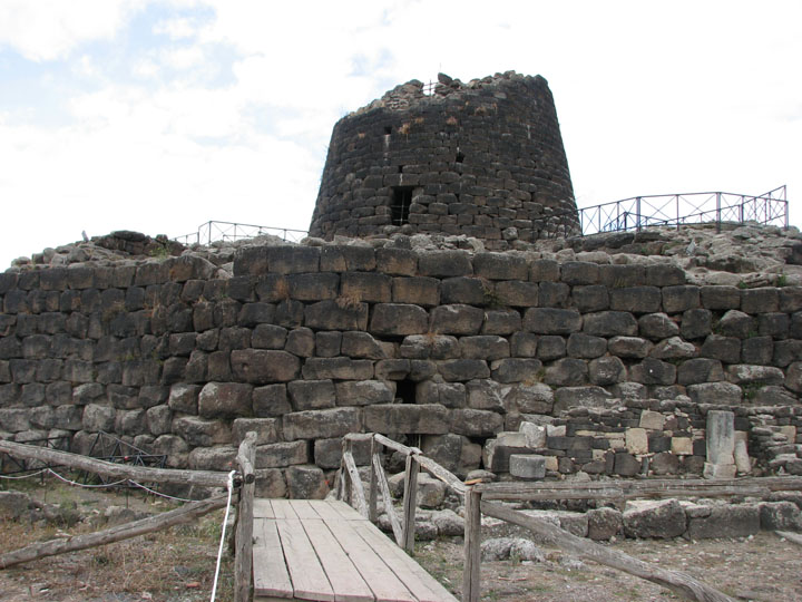
The central tower or keep used to be about 25 metres tall, but is only about 17.5 now. Entering this from the east-west courtyard, there's a corridor that rings the chamber to the right and a staircase to the left. The ground floor chamber has an impressive tholos and is 5.25m wide and almost 8m tall. Following the winding staircase up to the second level, there's another tholos chamber on top of the first one and this room has several storage niches visible and a low bench seat along its walls. Up again to the third level - this room is now open to the air, hence the reduced height of the tower - with superb views over the surrounding settlement and across the valley and the numerous other nuraghe in the vicinity.
The light had changed in the ground floor corridors by the time we came back down again, from the initial warm orange to a beautiful cool blue grey.
A stunning place!
 |
On the way back towards the car, I asked in pidgin Italian and sign language about a tomba di gigante (Su Igante) I had marked on my map, less than 1km from the nuraghe, and as we'd not spotted it, we were not surprised to be told it was underground - though how much remains we never got to.
I knew there was another tomba in the vicinity however, and had approximate directions but wasn't sure which of two roads to take - the lady from the ticket booth scanned the guides and maps on the rack, and pulled one out and then took it into the cafe to spread out over the freezer so I could see where to go - she was quite happy to just use it to give us directions, but when we saw how much information it had, we knew we had to buy it. 2 euros very well spent!
Despite the continuing disturbing noises coming from under the car, we headed away from Torralba and turned left just before the railway line and stopped briefly for a slightly closer look (ie not from Santu Antine with binoculars!) at Nuraghe Fraigas and then Longu and Culzu beyond that.
At the T head, we went south east over the railway line - not fancying a dodgy walk up the tracks to Nuraghe Ruju - in search of the group of sites I'd enquired about earlier, and found the first one really easily.
An unloved tomba not far from Santu Antine. It's not signposted, but is easily visible from the road running south east from the easterly railway crossing near Torralba. After the crossing, you go over the river on a bend, and when you see a track to the left, stop - the tomba is in the field just after the turning.
We climbed over a wire fence to get access.
The stele, though weathered, is impressive. About 3m high, with relief carving and that pink tinge to the stone we'd seen at several other tombas. The area is quite overgrown, and it's hard to work out much of the burial chamber.
By now, it was getting late in the afternoon, and despite having some research on a few nearby sites most of which were marked on our new map, we decided to leave those for a future visit and see how noisy a drive it would be home.
Another day of rest (I refused to drive anywhere!) followed, and then on the Wednesday it was time to check out and head back to the airport - but with one little detour on the way. Time to visit the site I'd actually planned as a potential first stop - but we'd missed the turn on day 1 when we opted to go and check in rather than try to find an alternative route.
From Olbia airport, head west and watch out for the sign to Loiri - even though you want to go south and logic says that's left, it's a right turn.
Second time lucky, we got on the right road - the SP24 - and turned off at the sports pitch mentioned in TME - the tomba is signposted from here.
We parked in the area probably designed for those visiting Pedres castle, on the hill overlooking the site, having seen the state of the bumpy, sandy track, and walked the last 200 metres. There was a red Renault parked just by the gate in the low wall, and it turned out that it belonged to the site guardian - a lovely man! You can buy a ticket for 5 sites round Olbia for 7,50 - the others being:
Pozzo Sacro "Sa Testa"
Acquedotto e Cisterna "Sa Rughittola"
Nuraghe "Riu Mulimu"
Fattoria Romana di "S'imbalconadu"
but we only had time for this one, so paid 2,50 euros each. They may not get many visitors - the tickets had their prices overstickered for last year, if not the year before's charges.
This is one of the largest tombas in Sardinia, 28 metres long. As at Li Lolghi and Coddu Vecchiu, it's thought to be a reworking of an allée couverte.
The esedra is huge; the stele has been broken off and removed, leaving a stump of stone with a ridge down it on the left of the entrance, giving a good view down the funeral corridor.
We shared a few jokes with the guy working there - he'd spent 2 weeks in London a few years back and we all laughed at the phrases we could create in each other's languages - and found out from him that it isn't possible to visit the nearby Nuraghe Casteddu and Pozzo Sacro Trambuccone - good job really, it was almost check-in time! A 5 minute journey to the airport, and after 980km around Sardinia, we'd covered a very small amount of the sites I'd researched and/or located. So plenty to visit next time then!
If anyone is planning a trip to Sardinia, please drop me an email as I have a fair bit of dodgily translated info on most places north of Oristano. Best work on the south of the island at some point too, I guess.
|
Sardinian Saturday
We decided, after the long drive of the day before, to stay relatively local, and headed towards the town of Tempio, to continue from where we'd left off at the end of our first day out - Pascaredda.
On the SS127 about 5km east of Tempio, and directly opposite a sign "Nuchis 1", is the signposted turn to Pascaredda. Follow the track over the unmaned railway crossing and keep to the left fork as signposted. About 800m from the main road, there's a large parking area, but we took the sharp right turn before it, and parked 250m or so further on, just before the riverlet mentioned in TME (OK for small cars, and there's space to turn round just past the stream).
Free and open access.
We strolled up the path, with buzzing of thousands of insects filling our ears and butterflies and dragonflies flitting around, over the bridge and to the rear of the tomb.
A stunning spot! The trees are cork oaks and had had their bark stripped for the autumn harvest. Of the stele, only the bottom half is left; the 10 slabs on either side mark out the esedra, and a missing capstone lets you climb into the funeral corridor itself, and the sides of the corridor are buried with the earth bank rather than being exposed stone as we'd seen at other sites.
Again the granite had a pink tinge as we'd seen at Coddu Vecchiu and at the back of the funeral corridor, there's a shelf, as we'd seen at Li Lolghi.
  |
The rickety bridge on the way has been replaced ...

Our notes mentioned the nearby Nuraghe Agnu
and Fonte Nuragica Li Paladini,
but with dodgy directions and no images at the time to help us locate them, we didn't reckon much to our chances, so continued on.
Next, we went east, through Tempio - with a brief stop to be checked by the police at the roadside, and reminded to use lights in urban areas at any time of day (fortunately by this point we knew where the light controls were and could oblige) - and to the north out of town following signposts for Nuraghe Majori and its stunning views over the area.

On the SS133 about 2km north of Tempio.
There's a large car park on the main road by the signpost, though it is possible to drive up the track and park at the site itself.
There's a cafe and toilets (50 cent coin required, with proper disabled facilites), and slides and a roundabout for kids. The walk from the ticket hut (tickets 2½ euros each including an information leaflet and loan of a big torch!) has been thoughtfully laid out as a nature trail with the plants labelled, and wide steps or a gentle slope to reach the nuraghe itself.
It's set on a granite outcrop, and shows both styles of nuraghe building - the corridor and tholos.
Through the ESE orientated entrance into the corridor, there are tholos rooms on either side. Both are dark, but we'd been loaned a powerful torch, and there was another one left just inside the entrance (which has an impressive lintel); the room to the left has a niche, and we found a colony of bats resting there.
Along the corridor and up some stairs takes you to a semi circular room open to the sky, with further stairs to the left leading up to the terrace level, where there's the remains of another room, with storage silo, and fantastic views where you can spot if you know where to look many other nuraghe in the locality.
 |
We shared some jokes, a drink and some cigarettes with a charming older German speaking couple visiting at the same time and then taking a break in the basic cafe, and then set off northwards towards Santa Teresa di Gallura, and a lunchtime snack overlooking the most glorious beach, the Rena Bianca.

On the way into town, I'd spotted a "tomba di gigante" sign and we headed that way, to the west of town in the direction of Capo Testa.
This site is signposted off the SP90 from Santa Teresa to Capo Testa, with a left turn taking you away from the cape into the Santa Reparata area. Down the winding road, and then at the cross roads you are directed to the left - then a T head with no signpost. We went right initially, and rather than wander aimlessly, I pulled up and used one of my stock phrases I know I need to learn any language.
"Scusi, io non parlo Italiano. Dove è la tomba di gigante, per favore?"
Hand gestures and the phrase "non-asphalto" informed us that we need to turn round as we should have gone left, and up the hill, and then taken the track to the site.
We did this, and 180 metres or so from the main road, we looked at the left fork we should take, and decided to park and walk - of course seeing a few cars stopped further down the bumpy and sandy track. Just over 400 metres later, we spotted the concrete roof of some strange building on the left, and took a track to the right towards the tomba.
Free and open access to the area - no facilities.
The tomba reminded me, mainly due to its state of preservation, of Moru, the first one we'd visited. There's no stele, and no capstones; the tallest stone, at the entrance to the funeral corridor, is probably no more than 60cm high. But it does give a really good idea of the foundations and structure of a tomba.
There's a post and rail fence around it, but gates are provided.
Recalling my research notes - which were minimal for this site as I'd only come across it when trying to find an image of a different tomba a few days before we set off, and stumbled into an online gallery
http://www.catturalasardegna.it/thumbnails.php?album=5
and realised it was not far from our base - I headed away from the rear of the tomba to a path up towards the peak, shown with an arrow in one of the photos, and coming across an info board about excavations, I knew I was on the right track, and shouted to Beardy, who was still mooching about at the tomba, to follow.
The path from the tomba leads you into a wooded area - and then all of a sudden, there's the village.
A collection of recently excavated huts, with some impressive sizeable chunks of stone being used in their construction, are on the lower part of the slope, and climbing further up, we found a tower - now know to be the southerly one of two.
Climbing higher up the outcrop, to the left of it if looking from the tomba below, I spotted some construction hidden behind bushes just as you climb up a solid piece of rock to the peak - and the stunning view

and sure enough we squeezed through yet more mirtle bushes to find a nuraghe.
It's well hidden in the greenery at the top of the outcrop overlooking the village and tomba. So well hidden, you can barely make it out. But peering through the bushes, you can see bits of its walls, and right on the top of the peak, climbing through the undergrowth, we found a way into the short-due-to-landslides corridor of the nuraghe.
 |
A fantastic site - I'd seen the book (link to Italian version supplied) at a couple of the sites we'd visited earlier in the week, but never in English.
With the afternoon drawing on, we decided to head towards home, but with just one more planned stop on the way.
On the SS133 from Palau, about 3km west of the town and about 1.5km from the junction of the SS133 and SP123, there's a turn down the side of the Vecchia Gallura restaurant signposted "zona archeologica".
TME mentions a sign to "Tomba di Gigante S'Aiacciu" which later turns into a sign for "Li Mizzani" - these are in fact two separate tombas. See http://www.palau.it/tombe.html.
To get to Li Mizzani, it's about 4km from the main road - take the left fork as signposted, and go uphill, then downhill, then uphill again - carefully! It's narrow and winding, and precipitous in places, and you'll be needing first gear!
Eventually we found the sign to the right to the tomba, and parked there to walk down the slope and through the gate, to the left away from the church, and through another gate - where we found quite a few parked cars. It's about 350 metres in total from the signpost to the tomba.
Through a small gate, then to the left a few paces .... well, we obviously weren't going to get the place to ourselves, as we'd had at many of our other stops, but we weren't expecting it to be quite so busy!
Maybe a Saturday thing, maybe an equinox thing, maybe just local custom ...
There were a couple of people laid out on one side of the funeral corridor, one laid in the corridor itself with his head through the portal in the stele, and people sat either side of the stele; as more people arrived, they formed a queue sat on the bench seat around the esedra.
Someone asked if I wanted to join the queue - but I just wanted to take photos and wasn't entirely sure what was going on. Beardy meanwhile sat quietly right at the far side of the esedra. Every so often, the person under the portal would move on, and the next in the queue would take their place - all had come prepared with roll mats or doss bags to lie on.
Beardy was convinced the lady sat waiting was giving him the evil eye and, being unable to check out the tomb properly, we didn't stay over long. A strange experience - still, interesting to see the site being used for something.
Back downhill, uphill and downhill, we took the other fork to look for the other tomba, but unsure how far we had to go on a rough road, we decided to leave it, with plans to return another day, and hopefully see Li Mizzani again too.
So, back along the coast road home, with a Sunday of relaxation to look forward to, and to work out where else we could visit during the holiday.
|
|
Yorkshire based stone searcher and Cope music fan with intentions to be tidy and green, and with a fondness for baking.
Married to Beardy - at Castlerigg - and honeymooned round Perthshire, Aberdeenshire, and the Western Isles.
Recently taken to European excursions.
|