Beyond the Teanga Burican
I was surprised just how short and easy this walk was and just how fruitful the journey was to become with a wonderful array of sites ranged across the gentle lower slopes of Tormusk. They were only discovered in the late 1990's and they include three four-posters, numerous cairns, cists, stone alignments and standing stones spread across the hillside's lower slopes. I strongly advise plotting the sites carefully on an Explorer Series OS map from the Canmore site beforehand. A few feet of peat has been laid down since the sites were constructed, add to that a further two or three feet of growing heather, bracken, grass and reeds which conspire to conceal everything… but that is half the fun – seeing these ghostly, forgotten sites emerge from the undergrowth in front of your eyes! For those who enjoy bird spotting I saw seven different birds of prey (White-tailed Eagle, Golden Eagle, Kestrel, Buzzard, Hen Harrier, Sparrow Hawk, Merlin and Tawny Owl) in the leisurely hour and a half the walk took around this group of sites.
Directions - drive from Lamlash along the unclassified Ross Road two and a half kilometres beyond the Buddhist Retreat Centre. Park at the layby by the green sign marking the footpath to Shiskine. Or if coming in from Sliddery drive ½ km past Glenree Farm and park in the same layby. Take the Shiskine footpath and follow for ¾ km till it joins another path. Follow this path up the little wooded river valley. There is a fence on your right hand side. Descend to the ford (if the ford, riverbanks and riverbed is of red sandstone bedrock you are in the wrong place - return to the main path and follow it further upstream for 300m to the next ford). The path becomes a fine quad track. You will pass what appear to be three large capstones lying by the path. You will then find yourself passing through a gap in a large drystane and turf structure. This is the Teanga Burican and marks the beginning of the surprises! It might seem like the *rse-end of nowhere but this really is the beginning of everywhere – you just have to look carefully!
Standing on top of the Teanga Burican you can easily see a prominent standing stone on the hillside. Keep your eye on it as it is a useful orientation marker for the other sites. Continue up the path until you draw level with the standing stone and strike out confidently across the hillside towards it!
The West of Scotland Archaeological Service (WoSAS) report says that the prominent standing stone has a cup mark. I couldn't find one. Perhaps I'd found a different stone. This one was about 1 ½ metres high and slanting slightly. For some reason the photos came out all blurry – so it'll be next time for those.
Next, I headed up the slope looking for the first four poster 90-odd metres further on. All I could see was the mogre of near waist-high bracken and heather I was wading through. I felt my heart sinking… How on Earth would I find anything in this undergrowth? I counted off a hundred paces up the hill. Suddenly there it was! Right at my feet! The bracken had subsided a bit and the heather revealed a smashing little jaggy-toothed four poster right in front of my eyes! The stone to the North East is fallen, but lies right where it should be, snug in its peat and heather bed. The views back down to Bennecarrigan and the coast at Sliddery are stunning. The four poster sits on a broad gentle tongue just a few hundred feet up, but its elevation and situation on these empty moorland slopes give it a real lofty vibe.
|
Mitchelhill Rings - Sunday 7 November 2010
A couple of hours free, I plumped for Mitchelhill Rings, a stunner of a hillfort on the eastern shoulder of White Hill. I nipped through Biggar out past the Rugby Club, over the top at Crosscryne and descended into the lost valley of Kilbucho. Parking isn't hard but it isn't easy. There is a fairly wide verge with some great old Beech trees at the side of the road nearest the hillfort (over the years I haven't found anywhere better or nearer, but tuck your car right onto the verge as this is a narrow road with tractors and farm equipment rattling up and down it). Across the road from a little cottage go through a gate then follow the burn to the base of the hill. You can either go straight up the side of a forestry plantation or follow the track which winds up to the right. I just go straight up. The fort is about 300 feet above marked by bumps on the skyline. Once you reach the track halfway up follow the line of the spring which trickles down the side of the hill (it is betrayed by a fine healthy growth of reeds and a trickling sound). The source of the spring is just below the level of the fort, where (one above the other) two deep, mossy, reeded-up basins about twelve feet across and six feet deep catch the water of the spring. As I stood after the steep ascent, gathering my breath, my heart pounding (as it frantically tried to squeeze blood through my larded-up arteries), I wondered if the fort builders might have created these basins as an easy way of gathering an easy water supply on this high hilltop.
From the fort the views are incredible, the remains are impressive and look out over the gap which leads through to Broughton and Drumelzier. The isolated valley which Mitchelhill Fort broods over is an incredible place. It has no less than eight hillforts stretched across a space of less than four miles by one and a half miles. They guard this lonely valley's few narrow entrances and exits. Many of the hillsides are scarred with rows of cultivation terraces, at least half a dozen "settlements", many enclosures and I'm sure the modern roads pretty much sit on what went before. There are a number of burial cairns and one (possibly the pretty much destroyed one on Threepland Hill) held some very important people because two identical gold lunalae were discovered in 1859. Bronze Age axes and spears have also been found in the valley as well.
Sometimes a good map or diagram is worth a thousand words in helping to describe or imagine a place. here is a link to an OS map of the valley with the option of clicking for aerial view etc.
http://www.bing.com/maps/?v=2&cp=55.59186199568212~-3.505965423583973&lvl=13&sty=s
I had intended making the short crossing over the top of White Hill to Cow Castle hillfort for a few pictures - but the beautiful, still, frosty afternoon suddenly took a much more aggressive turn and first sleet, then snow began blowing in horizontally. I descended back down by the spring and said hello to a farmer and his collie dog as they rode their quad along the hill track carrying some bags of sheep feed. They waved back and headed further round towards Kilbucho. I was back at the car in ten minutes and in front of my fireplace ten minutes after that. The sleet battered at the window and I reached for the log basket. I was glad I was not trying to keep warm at Mitchelhill Rings.
|
Splendid Isolation – Crookedstone - A Stone Alone
31 October 2010
My domestic duties done and household chores completed I nipped out for a couple of hours to seek out the Crookedstone. I turned out of the road-end and headed south on the A702 into an afternoon of perfect autumn stillness, brilliant sunshine, blue skies and rusty coloured hills.
I turned onto the B7076 after Abington and stayed on it, by-passing Crawford and ignoring the signs willing me to visit Elvanfoot and Drumlanrig Castle. After another mile, the B7076 curved over the M74 and a wee signpost bearing the legend "Crookedstone" pointed to a turnoff. I drove down and came to a wee level crossing. You have to cross the main Scotland/ England West Coast Rail Link to get to this site. The crossing gates are hand-operated and to raise them you have to pump them up by a handpump. I quickly changed my mind when out of nowhere a Virgin Pendolino hurtled past me, causing instant sphincter tightening fear and sucking the breath out of my lungs. I decided to leave my car where it was and cross the tracks by the wee pedestrian gates. I crossed rather quickly and was immediately spotted by a gang of sheep who showed a vague interest in me before rushing off along the peaty banks of the Clyde Burn like an absurd impulse towards Elvanfoot.
I tramped the half mile or so up the farm road. The stone is in a field next to the farmhouse and as I approached I was greeted by three large snarling, barking hounds. Thankfully they were behind a high fence. The racket brought out the farm's occupants. They looked rather surprised to find a visitor wishing to see the stone but were not in the least bit "off-ish". The farmer was kind enough to point me a way to access the field with the Crookedstone in it, and asked me to close the access gate firmly as there were tupps in the Crookedstone's field who were aching to attend on the ewes in the adjoining field.
The stone is about two metres long and stands about one and a half metres high, pointing upwards at 45 degrees. It is covered with large natural looking cup marks and leans Northwards in its gently sloping field about a mile across the flat valley floor of the River Clyde from Air Cleuch. The top of the stone's profile appears to mirror that of a fold in the hills to the North-East. I wondered about rising sun alignments. I wondered about the robbed-out cairns I'd seen at the side of the field. I wondered about the strange isolation of the site. Cut off on the West and South sides by the River Clyde, Daer Water and Potrail Water, cut off by heights of Beattock Summit to the East and completely cut-off from the North by the M74, the B7076, the West Coast Main Railway Line and the Clyde Burn.
A mile or so to the South there is a MASSIVE early settlement site which covers a wide hillside near the Daer Reservoir. With masses of material from the Scotland earliest visitors through to the very first farmers, it's been under excavation for nearly five months with the hearths and tool finds right below the bottom of the peat. I wondered about that too and those first farmers checking on equinoxes, planting crops and keeping animals. The hills and valley floor here have three feet of peat growth on top of them now. The Crookedstone seems to stick a lonely finger up from its grassy field and say "We were here".
On the way back down the farm road I climbed uphill under a couple of nice old Scots Pines and checked out an alignment of three stones I'd spotted on the way in. Set in the turf a couple of feet apart only their topmost edges and one side jutted out of the turf. When I reached the little terrace where the stones were I saw they had a range of cups on them, some very large, some small and some which looked like pecking. The Crookedstone has natural cups on it but the cups on these three stones looked nothing like them.
Again I found myself leaving a site with much more to think about than when I arrived, but maybe that's how it should be. I'm detecting a pattern.
|
Druid - Friday 15 October 2010
After a delicious (and rather IN-expensive) lunch in The Catacol Hotel, we drove down through Thundergay and Whitefarland. Beautiful calm seas and high leaden skies lent the journey a sense of impending.... something or other. I'd not had my fly rod out on the holiday, and although the trout season had finished the October runs of Sea Trout and Salmon were in full flow. A lucky angler walked up to the bridge at Dougarie Lodge as we drove past. He was carrying what must have been a twenty-five pound Salmon. "Wow Look at the fish he's got!" I exclaimed. No answer. My OH was fast asleep in her car seat and the wee fella was snoring gently, slumped on his booster in the back. Hmm, I thought, free time for Druid!
I pulled over about half a mile further on and walked up to Auchencar Farm leaving the two dreamers to their dreams. The farmer was just setting his prize tups out amongst his ewes in the field with the stone and in the one next to it. he stopped on his quad and told me just to go into the field if I wanted. I've been up to the stone many times before and I politely declined, the view is so much better from a distance. You get a better idea of the scale of the stone. A bit of perspective.... Also, I hate to disturb a tup about his business, so I contented myself with brilliant views across the field toward the stone.
Druid is just such a brute of a thing. massive and phallic, a curving, bulging, priapus and yet at the same time it is one half of a very feminine shape (the other half lies broken beside it). There is a slight rise around the stones which could be a well robbed-out cairn but I'm not convinced. Some short cists were ploughed up between the stone and Auchencar Farm about a hundred years ago and a cremation urn was found about a hundred yards North West of the stone in the late 19th Century. The surviving stone faces towards the sea and it is highly visible. This stone was meant to be seen. We saw it from miles away, walking round from King's Caves at the start of the holiday. For the sea-going (and sea-arriving) early visitors, the 70 feet above sea level stones would have been a superb landmark as they arrived by canoe from the South up the Kilbrannan Sound. The stones would have guided them into Machrie Bay and two of the best salmon runs (The Machrie Water and the Iiorsa) on the South Western Seaboard of Scotland. There is an ancient (and large) tidal fish trap by the mouth of the Machrie Water and those runs of Salmon would have been immense in the Neolithic.
I returned to the car and the two still-snoring dreamers and set off for King's Cross Point, our wee holiday cottage and the promise of a game of the new Arran Monopoly set.
|
Dreamtime in Stronach Wood – 14 October 2010
I grabbed a couple of hours during the afternoon while Junior and my OH played with the latest consumer purchase – Arran Monopoly. While they were racing around buying up the likes of Catacol and Lochranza and vying for control of Arran Aromatics, I parked up on the String Road just at the pull-in, up from the stalkers path and headed into Stronach Wood.
I could hear shooting going on up in the hills and on Monday we'd watched and heard stags at the rut in the corrie high above Corrie, from the North Goatfell Ridge and all the way back down the mountain. There were fresh quad tracks on the stalker's path all the way to the carvings. The carvings are about half a mile along the path and actually are the path. This is a shameful state of affairs. For the want of a few felled trees, some fenceposts and a hundred yards of fencing wire, foot and quad traffic could be diverted off these beautiful panels. It wouldn't stop the interested folks getting as close as they wished but it might stop the wear and tear of unintentional damage from the through traffic.
I photographed the panels and checked out some triangular pointy peaks on the panel slightly above the birds I'd noticed during the summer's visits. They appeared to mirror the view to the pyramidical peaks of North Arran (Goatfell, Cir Mhor and Beinn Tarsuinn).
http://www.themodernantiquarian.com/img_fullsize/91813.jpg
With the forestry plantation still surrounding the panels, photographing them with the back drop of the peaks wasn't possible – but it will be one day! The illustrations from Coles (1901) nearly show the orientation (it would be slightly more turned to the right).
http://www.themodernantiquarian.com/img_fullsize/88438.jpg
The panels in the Kilmartin Valley haven't suffered by being displayed well. This site could easily be cleaned back and should be properly examined. Without a doubt, there is much more art to be found around the three exposed panels. I was looking for some more…
You see, I'd had a wee plan to seek out the lost panel (panel K) reported to be 80 yards to the West back in 1901. It hasn't been seen since and was thought to be buried by bulldozer action in the dense forestry plantation. I paced and measured. I measured and paced. I retraced my steps and thanked my lucky stars it was October and the midges were all dead. After a while and right on the eighty yard mark I came across the edge of an eight foot slab buried in soil, pine needles and peat. It was right where it should be and had a plantation tree growing on top of it. I had no spade, trowel, GPS or axe. I photographed it.
http://www.themodernantiquarian.com/img_fullsize/91712.jpg
From my memory the exposed edge looked rather like the top edge of the slab shown in the very poor 1901 photograph here
http://newimages.fotopic.net/?iid=yr16tt&outx=0&quality=100&original=1&noresize=1&
I was kicking myself for not bringing at least a wee trowel, so I promised myself yet another trip over to Arran later this year - this time properly equipped to shift some of the soil off this likely slab. It didn't look like anything worse (or more) than the peaty spoil from the drainage ditch between the planting lines for the trees had been heaped up on top of the slab. Then the trees had been planted and had been patiently dropping sixty years of pine needles on top of that. So maybe I'd found panel K? A winter trip was definitely on!
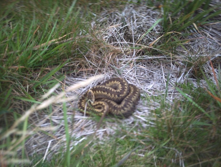
With myself exhausted and the camera battery dying, I headed out of the forestry, onto the top of the Stronach Ridge and wound my way along a rocky crag-edge on the lower slopes of Muileann Gaoithe heading towards the Parking Area and cairn at Allt Mor at the bend halfway up the String Road. At one point below me, a large slab of rock at the side of the ridge-crag formed a great-looking rock shelter enclosing a squarish area the size of my living room. I checked my map (I aint got no GPS) and it was at NR 995 360. I climbed down carefully to have a look and nearly put my foot down on a BIG Adder.
http://www.themodernantiquarian.com/img_fullsize/91814.jpg
It hadn't sensed or seen me. It lay dozing, coiled in a considerable heap in the last warmth of the afternoon in the rock shelter. I leaned down as close as I dared and snapped a picture. It woke and slid very quickly into the long grass. It was between three and a half and four feet long. A BIG Adder! I legged it out of the shelter pronto. I'll have to go back in winter for a photo of the rock shelter too.
I got back to the road and decided to forgo the cairn at Allt Mor and head down the hill to my car. I'd had enough excitement for one day. Stronach Wood... it's the gift that just keeps giving. Go get some I say.
|
Blimey - They've let this place go a bit! 14 October 2010
This place has a few names. Lamlash Road Circle on Canmore. Blairmore Circle locally. Lamlash Stone Circle on TMA. They were the first stones I ever visited on Arran over thirty years ago. Regardless of what the circle is called, this group of stones occupies a superb location, albeit rendered rather impotent, being hemmed in by hundreds of acres of Sitka Spruce on both sides of the road (thoughh to be fair, some of the forestry is at last being cleared). As I approached the outlier, I set up a Barn Owl which had been using the stone as a perch to vomit up its pellets. It lifted off silently and drifted into the trees towards Clauchlands leaving its last pellet on the outlier, steaming slightly in the cold of the morning.
The four surviving stones are perched on a slight knoll, at the highest point on the road between Lamlash and Brodick. The stones were barely poking their heads up out of the mass of heather and bracken. The site used to be regularly cleared of the heather and bracken though this hasn't happened for a for a while!. A few years back a fire caused some cracking and damage to the outlier. A rock cut cist was found in the centre of the three main stones but isn't exposed nowadays. There are other large stones half hidden under the peat on and around the mound. There is little to be seen or made sense of here now. This site should be an almighty place. It should look North to Goatfell, Cir Mhor and the jagged ridges of North Arran. Instead it is hemmed in by scrubby Birch, Willow and the massive Spruce plantations of the 1930's and 1940's. To the South, Holy Island, Blairmore Standing Stones and the robbed out Dunan Beag and Dunan Mor cairns are now invisible, swamped by forestry.
Through the forestry track another mile to the coast leads you to the hillfort at Clauchlands (not listed on TMA). The forest trek takes you through some of the best Pitchstone areas on Arran and you can grab yourself a little souvenir pebble of the shiny glassy stone our ancestors loved so much. A beautiful circular walk takes you back to Brodick by the very best pitchstone outcrops at Corriegills.
I believe that one day these stones at Lamlash Road could be sympathetically restored to something rather special. The site's original majesty was in its location. With the forestry removal currently underway on this magical island there is a real opportunity to re-instate the views and carefully excavate the peaty knoll and its immediate surroundings for the surviving stones fallen comrades. But I wont hold my breath.
|
Back To The Old House - 24 October 2010
Back in Ayr for the weekend. I was born here and my parents (177 years between them) still live in the house I grew up in. I really hadn't thought of there were any sites I could visit or photograph while I was visiting. But of course memory sometimes drags one up...
A dazzling sunny October Sunday meant a wee drive up to the top of the Carrick Hills for the most incredible views of Arran. The crystal clear skies meant we could see cars and houses on the island far across the Firth of Clyde. Driving back into Ayr along the coast road I suddenly remembered Stonefield Park! My OH had her camera - Oh Yes! In my early teens, my best pal used to live in the street next to the stone and it was our rendezvous point where we'd meet up on our bikes. Thirty five years later, I pulled off the Doonfoot Road and found this old stone just where I'd last left it.
It stands on a wee patch of grass with a few nice trees around it in a very quiet street. The actual site could hold at least two house plots and is worth its weight in gold in a rather exclusive and very expensive area of Ayr's housing. I think we are very lucky this six footer wasn't bulldozed back in the sixties when the nearby bungalows were built.
The stone is quite cheese - holed on one of its faces. There is a certain phallic element when viewed facing North . There is absolutely no landscape context in which it is possible to view this stone, but it really does give the little street a quality which no other street in Ayr has.
|
Torr an Loisgte
Notes in Grey Weather – Morning 13 October 2010
With a grey morning mist and low cloud across the Firth of Clyde, I set off early to seek out Torr an Loisgte. I'd been intrigued by Greywether's pictures on here and had been longing to check out the site for myself. Torr an Loisgte was my "must do" during this October week with my family on Arran. We were staying at one of the cottages at Point House at King's Cross Point and from a vantage point on the way up the winding access I could make out the Giant's Graves on their now deforested terrace. On my OS Explorer map the cairn appeared to be a couple of hundred yards to the West and about 45 feet above the [Giant's Graves].
I parked by the bus terminus at the South end of Whiting Bay and headed up the Glenashdale Falls Path. I took the left turn up the steep hairpin bends of the route to Giant's Graves. They used to have hundreds of steps cut into the path years back and I'm glad they have relaid the path. The circular route via Glenashdale is a bit gentler on the way in but I was in a bit of a hurry, having haggled an hour or two off from my OH and Junior. I was up to the Giant's Graves in fifteen minutes, sweating out the previous night's Cab Sauv and replacing it with a generic supermarket version of a popular energy drink. The Giant's Graves had been visited by some ***** who'd lit a fire close in by the North cairn and piled up felled tree trunks over the chamber like some kinda log roof. I couldn't leave it like that and kicked the hearth and ashes into the felled forestry then I tossed the trunks off the edge of the terrace like a salvo of cabers. Job done, I pressed upwards and onwards.
Greywether described Torr an Loisgte as "Not easy to get to". Times change. It is now impsy-pimpsy, easy-peasy since they felled the forestry. Simply continue on the wee footpath from Giant's Graves until you reach the old forestry road. Turn right, follow it round the hillside for about two hundred yards. Stop at the picnic table by the roadside and scramble up the bank above the road. This large cairn is behind the wee hillock in front of you.
I wasn't quite prepared for the sight which met me. A pandemonium of tumbled stone, half opened chambers and hints of a huge façade all coated in a thick blanket of moss, turf, peat and lichen. I found it very difficult to get a handle on the site at first, as the layout of visible chambers seemed to make little sense in relation to each other. Strange uprights emerged from the middle of the cairn, there were obvious chamber collapses in some areas and only one area (the North end next to the wee hillock) seemed to be in its original state. I could not work the visible and slightly open capstones into any kind of sensible orientation, and the notion of a row of central chambers seemed farcical given the carnage which faced me. Even the façade seemed to start going one way then I'd find a second row of façade uprights which bore no relation to the initial one. The cairn was only first reported in the 1970's and as far as I know has never been excavated. Downhill all that is really left of the Giant's Graves are the central chambers and a few façade stones, the cairn material now exists as a series of drystane dykes which run around the hill below. In comparison, Torr an Loisgte appears to be fairly complete and unrobbed, but the central and southern end look like someone has taken a JCB and pushed it around. To me, trying to make sense of Torr an Loisgte was a bit like looking at heap of scrap metal and trying to work out how a car works. I am sure there is a LOT of archaeology still in Torr an Loisgte and its comparatively recent discovery ensured it escaped the attentions of 19th Century treasure seekers and gentleman antiquaries.
I took a set of pictures and found my OH's complex digital camera had stuck itself on Black and White setting. I couldn't get it back to colour so my apologies for the monochrome set. I sat on the wee hillock and gazed out to Holy Island drinking in the view and the early morning quiet. No-one from TMA had contributed any notes or photos since Greywether's visit back in May 2005 and I wondered if anyone at all had been up here since then. This long forgotten cairn does not even have an agreed name "Torr an Loisgte" here on TMA, "Torran Loisgte" with the Ordnance Survey and according to Canmore the hill is called "Torr on Loisgte". Even the gaelic word "Loisgte" is a bit vague, my limited knowledge suggests it means "Hill of the fire" or "Hill of the burning". I returned to my car by the Glenashdale Falls path… more confused about Torr an Loisgte than when I arrived…. but in a good way.
|
Deer Park - 12 October 2010
The simplest way to approach these stones is to drive North out of Brodick towards Corrie. Pass by the Cladach Retail Outlet Village and continue along the coast road for a few hundred yards till you get to the vehicle entrance to Brodick Castle on your left.
Drive up to the Castle Carpark (there is no charge for parking or for simply passing through) and then exit the car park (there is a one way traffic flow system through Brodick Castle grounds) and continue through the castle grounds. You will pass a house on the right called Kennels Cottage and then descend to a small bridge at the start of a stretch of road bounded by Beech Hedges on either side. Pull in here and park. The field with two stones is on your right. The solitary stone stands in the field on the left. They are seperated by the Castle driveway exit road.
The largest stone A is about twelve feet high, stone B thirty yards away is 9 feet. Stone C in the next field is nearly eight feet (and leaning!)The three stones seem to form some kind of an alignment, but with the Beech hedges and road in between it is difficult to judge precisely what. There is sufficient space for two intervening stones. The Brodick Heritage Centre has on display, a cist which was found on the same alignment, thirty yards from stone B towards stone C. It was ploughed up in 1980 and contained an intact food vessel.
These fields are under barley almost every summer and usually you cant get near the stones till after the harvest. It is now under grass and yesterday was full of jumpy inquisitive stirks. Thankfully they have been moved elsewhere today and I can get right up close to these big stones. The tallest one has the traditional Arran Sandstone fluted and weathered top. The site reeks of having been something bigger originally but this flat, fertile land is at a high premium here in the more Northern end of the island and has been under the plough for many centuries. It is easy to imagine that there was once much more to this site than the three surviving roughly aligned stones and the cist. However it is what we have left and for that we should be glad.
|
October Moyish Frenzy - 16 October 2010
An hour till the ferry
Shaggy-haired Junior dodged a bullet, what with Jimmy the Brodick Barber being shut on Saturdays. So instead of a a much needed clipping, he and my OH popped off to purchase bespoke chocolates and play crazy golf. I checked my map and decided on Moyish. I had last been up to the Moyish stone more than half my lifetime ago, as a teenager on a camping holiday. I'm still coming to Arran...
I had time for a quick scoot up the road beside the Co-op and turn right, then first left. Time was not on my side, the hot October sun beat down on me and I regretted wearing my fleece and jacket. I found myself puffing and panting my way up the street in a small housing estate. A children's play area lay ahead which hadn't been there thirty years ago, I climbed over the fence at the back, turned right through a hedge, crossed a deep, steep sided stream, over a barbed wire fence and through a gorse hedge.
An absolute beauty of a stone. A giant in the regular Arran monolith style, it stands with a slight lean to the East. Its top is fluted and weathered like the tallest ones on Machrie Moor. It stands on a fairly level field terrace high above Brodick with superb views East to Mainland Scotland and North to Goatfell and Cir Mhor. Set in a reedy field bounded on the West by a Beech and Hawthorn hedge with turning leaves and deep red berries. I lean against the stone and rest for five minutes drinking in the view, the peace and the last seven days spent here on Arran.
Wandering back down the hill with the car parked in line at the ferry terminal and Junior and my OH sitting waiting for me on the Co-op wall, it didn't feel too bad to be leaving Arran. I know we'll be back again next year and Moyish had hit me with a last minute boost.
|
11 October 2010.
We headed South through the forestry from the car park a mile or two south of Machrie. The car park is well signposted and a visit to the caves is best done as a circular walk. Over the years we have built a preference for walking in heading South and returning to the car park along the cliff walk to the North of the caves. It just seems easier, and this walk does involve walking over a few hills (The Big Hill of the King - Torr Righ Mor) on the way in and (The Little Hill of the King - Tor Righ Beag) on the way back. The shortened name Tormore is given to an area of farms a mile to the North.
Just three short months ago we were here in baking summer sunshine. Now today the wind is driving into us with an arctic blast although the sun is shining brightly. My other and better half thoughtfully carried my fleece and waterproof out of the car boot leaving it usefully hanging in a wardrobe in our cottage at King's Cross Point on the other side of the island. I pulled on my hat with earflaps and gritted my teeth as we marched into the wind. Junior ran ahead doing aeroplane impressions along the path. It takes about twenty five minutes of stiff walking to get to the cliffs above the caves and begin the descent.
(Anyone with kids who visits this site might want to detour up the first burn along the shore to see the dinosaur footprints on a sandstone slab. There are also more dino-footprint trails on the Cleats Shore below Bennecarrigan between Torrylinn and Sliddery on the South end of the island)
There were plenty of visitors on the Sunday lunchtime when we visited. They all really focussed in on the main King's Cave. Some christian person had thoughtfully painted yellow emulsion over an ancient incised cross. Although I dont do chalking of cups, rings, carvings etc I can understand why people used to do that kind of thing. But this emulsion is new since July, so what gives? Why? I suppose I should be glad they didn't daub their cornflake yellow Dulux over the human figures, cups, rings, Ogham writing, fish, deer and curly celtic snakes. There is also an enormous amount of graffitti from the last couple of hundred years. And everything is covered in a semi-congealed, cave-slime concretion which makes photography difficult in the deep darkness.
We picnic on the shore further along and then explore some of the other caves. A few of the others have graffitti and carvings. There are about twenty caves in all and a few natural arches. There is a superb cave, fourth in from the North, which has a twenty metre long "corridor", a metre wide, which ends with a great chamber off on the right of the "corridor". I got a bit ruffled in the very dark enclosed space and had to leg it out pronto. I would have been useless in a Chilean Mine.
The walk back out is an easy one, once you are up on the cliff top. Out at sea, the wind whipped the Kilbrannan Sound into a froth of dancing white horses and reminded me that I had no fleece or jacket. Once the path opens out beyond the forestry the views North are spectacular. Machrie is spread before you and in the distance the big solitary stone at Druid stands out like an exclamation mark near the mouth of the Iorsa.
The caves are well worth a visit, the whole visit can be done in about two and a half hours (taking your time) and while the site is listed here as of uncertain antiquity... you'll be in no doubt that these caves have been used by people for as long as they have been landing their boats on Arran's shores.
|
Dreva Craig - Wednesday 8 September 2010
This site is a cracker. Not least because it nestles on its hilltop, a mere two minute walk from the road (a very handy wee car park and fence stile). The fort is surrounded by many upright stones which form a chevaux de frise along most of the approaches. The chevaux de frise has survived incredibly well considering its closeness to the cleared pasture fields (with their excellent dry stane dykes) which surround it. Once I'd manouevred my way to the tumbled defense walls I found myself staring into the remains of some dwellings which had been inserted into the thick stonework. The view from the highest point inside the fort is spectacular.
There are steep crags which would have needed little in the way of defence construction on the Drumelzier side of the fort. The village of Broughton is only three or four minutes away in the opposite direction but this fort seems more to do with tiny Drumelzier across the Tweed in the valley below.
The twin forts of Tinnis Castle Hill and Henry's Brae sit perched on their conjoined hilltops across the other side of the Tweed beyond Drumelzier. Below, where the Drumelzier Burn flows into the Tweed, I could see the Whitethorn tree which marks Merlin's grave. On the way up the Dreva Road, I passed Merlin's huge, flat-topped altarstone by the roadside at Altarstone Farm. Far below and halfway down the Tweed to the altarstone sits the lonely menhir on Drumelzier Haugh. Folklore, Prehistory, Iron Age, Medieval. A very busy little stretch of my corner of Scotland.
I watched the sun set somewhere over behind the hills near Kilbucho and headed back home for hot chocolate and bed.
|
Pandemonium on Drumelzier Haugh Thursday 9 September 2010
This is not the easiest stone to get to. The last time I visited was about ten years ago and it was a simple walk across two fields of barley stubble between the stone and the Drumelzier - Dawyck road. Those fields are now under a ten – twelve foot high Willow plantation. When I looked from across the Tweed on Dreva Craig on Wednesday evening I could see the stone occupying a little fenced off corner still under grass.
I parked at a pull-in near Dawyck and started the walk in only to be met by a big herd of very flighty sheep with a big horned ram snorting and stamping at me. I live on a farm and I'm used to livestock, however the beast obviously felt I was a threat to his harem of a hundred ewes so I quickly moved myself to the other side of a fence and continued towards the Tweed. I was then chased by a barrel-bodied pony-horse hybrid which galloped up to me and kept nudging me in the small of my back with her snout. In order to escape Dobbin's attention-seeking behaviour, I carefully picked my way over a collapsing dry stane dyke injuring my shin and found myself faced with a six foot burn to traverse. Despite a long, limping run and jump I fell short of the far bank and ended up knee deep in the burn. Still a field length to go before I could reach the Tweed and the walk upstream to the stone, I picked up my pace and was met by a gang of stirks as I turned the corner to cut along the last field boundary. These young bullocks were very agitated by my presence and stamped and huffed at me from the other side of a too-low fence. I felt my enthusiasm for the lonely stone trickle away like the stinky water oozing out of my bootlace holes. But I squelched on anyway. The bullocks formed a guard of honour on the far side of the fence and mooed loudly as they accompanied me on the last stretch of my journey to the stone. The sun had already passed behind the steep hills which hem in this lovely valley.
Then the stone was in front of me. What a delight! Lichened, squat and sitting proudly in its little fenced-off reserve, its angular wedge top cocked a snoot at the sky's dying light. On one of its lower faces, the stone appeared almost glassy, like the blue-ish chert which I keep finding in my tattie patch. Now hemmed in by the willow plantation, the stone is sort of cut off from the wide valley floor which it used to look out on. Did it have any brothers or sisters originally? I could see no tumbled brethren and no big stones re-used in the dyke which propped up the low fence which was still holding back the bullocks. I was surprised to see the ring ditch and soutterain were visible close by in the stone's little fenced-off reserve. Their outlines were betrayed by deep curving lines of clover growth and they were exactly as they appear on Google Maps.
http://maps.google.co.uk/maps?hl=en&safe=off&q=drumelzier&ie=UTF8&hq=&hnear=Drumelzier,+The+Scottish+Borders,+United+Kingdom&ll=55.604846,-3.367385&spn=0.000642,0.001714&t=h&z=19
They proved impossible to photograph from ground level of course.
The return tramp to the car held a similar spate of livestock incidents as my outward journey had and I got wet twice more evading livestock and making unnecessary crossings of what turned out to be a loop in a burn. The fates continued to conspire as an engine warning light and a SRS seatbelt light came on simultaneously en route home. Pandemonium indeed.
|
This Is Very Steep... site visit - after tea - Monday 30 August 2010
The best approach to Arbory Hillfort is to take the minor road (Station Road) from Abington village and drive over the railway bridge and cross the River Clyde. Take a left turn at the junction after the caravan site, drive on for another third of a mile and pull in at the parking area on the left. Cross the road and head along the very straight track across the field below and to the right of Arbory Hill. This isn't the mighty Roman Road from Crawford Fort (it descends further up ahead). This field track ends in a large levelled area across a small burn from the foot of Arbory Hill. Descend to the burn, step across and start the climb.
It is steep.
Very steep.
Very, very steep.
I found myself having to stop for breath regularly and look South. I couldn't help it as the massive road terrace scar of Roman engineering had started to become a magnet for my gaze every time I stopped (which was a lot). It was seven o'clock or so when I started up from the burn and it took half an hour of hard climbing (with breathers) to get to the first line of the defences at the hilltop. The summit is at 1400 feet. The climb feels like twice that.
http://maps.google.co.uk/maps?hl=en&ie=UTF8&ll=55.496588,-3.672078&spn=0.001288,0.003428&t=h&z=18
Arbory Hillfort is a mighty construction. The first scarped rampart bank is around a two metre climb up from the outer ditch. At one point it was easily three metres up. The ditch here is littered with tumbled stonework from the first rampart wall and some of these stones are large (5' x 3' x 2' was the largest I saw tumbled into the outer ditch). There are about five yards between the first rampart and the next ditch. The rise to the top of the next rampart is around another three metres up from the second ditch. You are now in the interior of the original fort. But five or six yards ahead lies yet another rampart which was inserted into the older fort at a later date.
This next rampart is not another steep grassy stony bank but an incredible eight or nine metre wide spread of tumbled stone which still stands around two metres high in places around its original wall line. This near circular stone rampart was originally three metres wide and must have been at least that height. There are two entrances both less than two metres wide.
I sat on the wall of one of the circular cell-like buildings built into this central stony rampart and looked across Upper Clydesdale as the setting sun turned everything a delicate orangey- brown. There was a distant hum from the M74 and the sounds of dogs barking in Raggengill Kennels far below. A buzzard soared above me, wheeling and staring down at me. There are a number of rather enigmatic features in this hillfort.
1. A series of circular, stone built chambers (about the size of a small room). Their walls stand to a height of two metres in some of them. One of them is around twenty feet long and rectangular with a rounded end. There are a series of much smaller scale ones just two or three feet across. The farm below the hill is called Cold Chapel and I wondered about those little stone chambers…
2. A row of cairns, facing West, built along the edge of the second rampart. They initially look like they have to be fairly modern but are well lichened and fast in the peat which has grown here. They stand up like a row of teeth. They are perhaps three to four feet across at the bottom and rise to four feet high or so.
The sun dropped behind Drake Law and Craighead Hill to the West and very quickly a deepening dusk sent me clambering down the steep slopes back to the present day. Arbory is an incredible construction. Atmospheric and enigmatic. I reached my car and drove home to cocoa, biscuits and a well deserved early night full of dreams about the strangeness of Arbory.
|
25 August 2010
Devonshaw is one of a string of hillforts planted along the western edge of the Upper Clydesdale Hills. Arbory, Kirkton, Bodbury are others within a few miles. I can see my work's cut out for the next couple of weeks...
There is a draw-in at the side of the A702 on the Northbound side of the road. Look for the gap in the crash barriers and draw in. If you miss it drive on, turn around a mile ahead and come back. This road is a death trap. There's a bit of nfty traffic dodging to avoid getting splattered by the stream of artics and juggernauts and a great opportunity for a barbed wire wedgey getting over the fence and onto the hill. The fort is then a ten minute scramble up the steep side of Devonshaw Hill.
Gradually the sound of the traffic disappeared as I climbed higher. On a terrace high above the road I paused for a breather and leaned back against an outcrop of rock. My nostrils were hit by the most hideous smell, when I checked behind the rock there was a half eaten, half decomposed sheep whose partial evisceration was spread across the green, green grass in a scene reminiscent of The Killing Fields meets Shaun the Sheep. My movement set up an immense cloud of blowfly and bluebottles from the carcass and I stumbled away across the maggot crawling grass trying to retain my dinner.
Like most sites in South Lanarkshire, Tinto is always somewhere over your shoulder and she looks onto Devonshaw Fort with a real massiveness. The fort itself is a delight, perched daintily like a fifty pence coin on a western spur halfway up Devonshaw Hill. The hut circles in the interior are clearly visible and the ramparts still very intact. The steep inner rampart is a real challenge to get up.
There are some big boulders which occupy the end spur of the outer rampart which look rather interesting. I'd often seen them when driving up the A702 and noted their monolith-like appearance. Frost shattered and earth fast, they are a group of sizeable stones which mark one side of an approach to the South entrance. On the hill above the fort there is an unremarkable grassed over cairn with a superb outlook.
I stretched out on the high western rampart of the fort for a while watching the lowering sun strafe the valley below, picking out its greens and setting diamond reflections dancing on the waters of the Clyde. Tinto looked on and said nothing.
Panoramic views and atmospheric. Highly recommended.
|
I'd photographed the main panels and was turning to go when I saw a strange looking crack in the steep step of rock in the ground between the cup and ring panels. I looked again. And again! My heart went into overdrive and I had to sit down. I thought it was going to burst out of my chest. I was looking at a three foor long, two foot high bird like a Raven. I stood up. I sat down again and approached it sliding along the peaty grass. I ran my fingers along the deeply carved beak and around the beautifully shaped head. I simply could not believe what I was seeing and touching. I took a photo with my other half's new camera.
When I looked back at the image on the camera screen under the trees, I saw what appeared to be a pair of bird's feet above the Raven's head. I walked over to check. As I looked in disbelief a Heron took shape. I could make out a bird below the Raven's beak. It looked like a Curlew. It wasn't carved out in deep relief like the Raven and Heron.
I resisted the temptation to wash off the deep coating of lichen, mossy slime and the peaty discoloured patina on the carvings and just started taking pictures as they were. The wind suddenly dropped and a horrendous midge attack ensued. I fled their bites shaking with utter joy. A sense of elemental elation carried me out of the wood and back to the car. I drove back to Lamlash. My head swam. I had to pull over at the top of the hill between Brodick and Lamlash and get out and get my breath back.
I returned a number of times that week. On the last day Mrs HD and The Boy came with me. They spotted the birds straight away (when I showed them the direction to look!). Suitably amazed, Alison took some nice photos. There had been a lot of rain the night before and that morning so the Raven was standing in a puddle of water and the carvings showed up better.
Reported the carvings by email to RCAHMS early in the week. Notified the Brodick Museum and Arran Heritage. Sent on the photos to both. I simply could not understand how these carvings sat in plain sight for so long without being noticed. A quick examination of photos on TMA and on BRAC showed the carvings visible but far in the background of Hob and Greywether's photos. In the 1901 PSAS illustration the carvings lie under a strip of peat and turf separating the known cup and ring panels. Hmm... I thought... When exactly did the peat and turf wear away? Drove to Edinburgh to examine Stan Beckensall's 2004 manuscript report and the photo archive at RCAHMS on Thursday. Beckensall never noticed them, his report contains no photographs. But I found M van Hoek's photo, it was exactly the view I needed and showed the strip of peat to be there in 1980 but a bit of the rock is beginning to show through. I paid the very helpful member of staff £1.18 for the colour photocopy of it and left.
RCAHMS got in touch today and asked me to pass the details on to Discovery and Excavation Scotland. So that's that.
So anybody going to Arran this summer, get along to Stronach Wood (very easy access and very close to Brodick) and catch some elemental revelation for free.
|
For about half the week this stone was flanked by a variety of wheelie bins. Wheelie bins need to be collected from the roadside and this stone has unfortunately found itself right on the verge so be prepared for your souvenir shots to feature a variety of coloured wheelies!
Park just across from the primary school and the the stone is right there by the car park. Dont get run over.
This stone had a partner. It lies tumbled in the woods across the road. Cross the road and go into Stronach Wood. Follow the low wall and fence line of the primary school into the trees until the school boundary fence turns to your left. Continue on your original bearing for the same distance again. Even in the undergrowth and trees it is hard to miss. I was out of battery power on my camera when I went... so no pic! Next time!
|
It was summer 1988 when I first visited this site. I'd approached it through deep plantation forestry and endured the clouds of firey midges which hung in biting clouds around it. Visits in the 1990's were no better. There were no views or any way to understand where this cairn stood in its landscape. All changed now!
The best way to approach these large Clyde Type Chambered Cairns is to follow the Glenashdale Falls path. Dont go up the steep signposted path if you want to avoid an excruciating climb! It is much gentler to walk on up to the falls and is really not much longer. You should walk the path right up to the falls then take a left along the smooth flat forest road which takes you around the hill. It makes for very easy walking and you are met with a spectacular view of the cairns as they sit in profile on the crest of their terrace with the Ayrshire coast behind them. The forestry has been completely clear felled allowing some wonderful viewing. You then walk down a gentle path on your left to the cairns.
The southern chambered cairn is aligned east/ west and looks directly to the black flat topped volcanic plug of Mochrum Hill near Maybole. These plugs/ igneous intrusions stretch from Scotland's West Coast to East Coast taking in Ailsa Craig, Mochrum Hill, Tinto Hill, Arthur's Seat, Bass Rock and the Lomond Hills.
The north chambered cairn sits on a north/ south axis and although only the massive cists are left in the centre, there are still large stones marking where the "horns" came out to. Views to the barbed peaks of Goatfell and Cir Mhor to the north are spectacular. If you are wondering where all the many tons of removed cairn material went... then on you way down the steep winding path look to your right and see the beautiful dry stane dyke which runs across the hillside! There's your cairn!
While munching a fish supper with my Mrs and kid the following evening, we could see the stumps of the north cairn from the path out to King's Cross Point in Whiting Bay far below. In its original state the cairn would have been very visible.
|
My 1994 OS Landranger map had not one but two sites marked at Stronach Wood - one being the main one here in Stronach Wood and the other a few hundred yards further up the hill. I decided to start with the one further up the hill then walk down to the next. The first attempt ended with me sunk in a bog, totally drenched, bearing many midge bites and harbouring a deep sense of failure and disappointment. Then I set up a big Red Deer deep in the insect infested bracken and heard gun shots break the afternoon air a few minutes later. My sense of failure and disappointment turned immediately to one of getting off the hill before I caught a stalker's bullet. I made my way noisily down to my car on the String Road determined toreturn and find the carvings. Getting changed back at the cottage I found a derr tick munching its way into my shoulder. Nasty creatures, they are difficult to extract without leaving the jaws in your flesh. It left a very painful bite which swoll badly and is still draining a week later.
The following morning I found myself back in the same mire and unable to find the stone as marked on my map. It took a third attempt to come to the conclusion that the old edition of the map was simply wrong or I needed new specs. I do need new specs but the old OS map seems to show two sites and I've posted the relevant map clipping to show folks where not to go (just in case their map is as old as mine was).
I bought the new OS Pathfinder edition and there was only one site marked! Once I had tracked down the deer stalker's access track off the main road I was at the carvings in a few minutes. But get this folks… there were quad tyre marks across the panels! (Once you shoot that deer on the hill you gotta get that yummy venison down to the butcher's shop and onto the plate somehow. Maybe Arran Heritage should take out a few of the plantation trees and take the path around the carvings…)
These carvings are groovy. I've seen many a cup and ring from Ben Lawers to Achnabreck but nothing had prepared me for the utter grooviness of these. Fluid and writhing… some of these seem to have a real sense of movement in them. A devastating midge attack suddenly ensued when the wind dropped and I had to flee the site but I was drawn back twice more during my week on Arran to look at and photograph some other stuff I'd seen up there - but I'll post about that once it has all been checked out and verified. If they are for real it will be a big WOW! But until things are verified then I shall temper my enthusiasm and say nowt!
The complete removal of the forestry plantations around Giants Graves above Whiting Bay has transformed the landscape they occupy. I'm sure this plantation at Stronach Wood will soon be due for clear felling as well. It will help with interpretation of the this site in relation to the megaliths in the immediate area and the notable landmarks in the landscape (Goatfell, Cir Mhor etc). There must be more art lurking under the peat on the red Arran sandstone which forms this hill!
|
The Air Cleuch burn tumbles down a steep sided gully in the hills above the Dalveen Pass. The Pass is an ancient routeway up from Galloway a few miles below. The rocky outcrop bears many cup marks and juts out above the right bank of the burn, about a hundred yards upstream from the wee bridge on the A702. The views are spectacular. The site looks across at the Daer/ Clyde watermeeting where the farm of Crookedstane has a standing stone. Together, the hills of Upper Clydesdale and the Moffat Hills mark the watersheds of the three main rivers in Southern Scotland, the Nith, the Tweed and the Clyde.
A couple of hundred yards above the outcrop, the Roman Road crosses the burn on its way from the lonely fortlet at Durisdeer to the fort at Crawford. Between the cupped outcrop and the A702 are three rather curious flat topped mounds. There are also earthworks of an ancient settlement a few hundred yards to the west and beyond that a ruined medieval bastlehouse. The hillside is littered with platform settlements, cairnfields and Bronze Age funerary sites. In the hills just a mile to the north, Lead, Gold and Silver were mined throughout the ages. This area is now pretty much deserted save for a few bored sheep, but it was a very busy place for us humans in the past.
Summer or winter, the site really has a desolate, empty feel and despite the nearby M74's best efforts, the silence of the empty hills wins over with peace, perfect peace.
|
|
I live in Scotland with my other half and my twelve year old son.
I grew up looking across the Firth of Clyde to Arran. I first visited the island in 1980. I've gone back a few times every year since.
|
