 
|
Visited 26 April 2013
A short cliff-top stroll from Paviland fort, Horse Cliff is a simpler construction than its neighbour and has suffered more in the couple of millennia since its construction. A single, curving line of defence cuts off the windswept headland. Several quarry pits have been dug up against the northern section of the rampart.
The views off the cliffs that form the western and southern bounds of the site are impressive and dizzying, especially down to the water-filled channel separating this headland from The Knave, coincidentally the next of the chain of multiple forts that top the cliffs between Port Eynon and Rhossili.
Worm's Head can also be seen from here, the western tip of the Gower peninsula. Beyond, the Pembrokeshire coast is dimly visible.
In all honesty, it feels less impressive that its neighbours, lacking the romance that the "Paviland" name conjures. Still well worth a visit though, especially on such a lovely day.
|
Visited 26 April 2013
After reluctantly leaving Goat's Hole cave, we make our way back up the gulley of Foxhole Slade. Passing the sheer cliffs that mark the southern extent of the promontory fort far above us, G/F points to the only slightly less steep grassy slopes to our left and says "we could climb up there". Fresh from the revelation of her enthusiasm for the inaccessible upper chamber of the cave, she's obviously feeling adventurous, so climb it we do.
This brings us out beside the inner rampart of the fort, with a dizzying view back down to Foxhole Slade behind us. We flop down on the grass of the flat interior to get our breath back.
This is actually my second visit to this fine little fort, as I came a little more than a year earlier on a coast walk with some friends. That was a rather flying visit, so today I'm keen to stay a while longer. It is very windy up here, luckily blowing inland over the cliff edge and unlikely to hurl us broken to our deaths far below.
The cave that we recently left is invisible in the cliff face below us, although we can see the "tongue" of rock that allowed us to scramble up to it, the far end now starting to disappear beneath the waves. The seaward aspect of the fort is pretty formidable, even if the tide is out only a lunatic would make any Guns of Navarone style approach to the defences from down there.
There are two certain lines of defences, one of which is further protected by an apparently rock-cut ditch. There may be a possible two further lines, although these appear more to be slight augmentations of the tilted planes of rock that form the headland and, indeed, the Gower's entire southwestern coast line.
We sit for a while at the exposed and windswept tip of the fort, above the "Yellow Top" that provides the alternative name. Exmoor can be seen hazily across the Bristol Channel, forming the far edge of the pre-Ice Age plain that once stretched sway from these cliffs.
It's a great spot, worth the longer visit this time round. We head off to meet the neighbours at Horse Cliff.
|
          
|
Visited 26 April 2013
Back in the autumn last year, as we made our snail-like way around the Glamorgan coastline on the newly opened Wales Coast Path, we promised ourselves a Gower weekend in the Spring. This gave us something to aim for, an elusive Shangri-la to spur our efforts onward, possibly more in hope that expectation.
So I'm mightily excited that we've reached the Gower on time and the long-awaited trip has even tied in with some promising weather. We're staying in Scurlage, but come down the day before our first walk. I've managed to remember to bring the tide times with me, ostensibly on the off-chance of a visit to Worm's Head tomorrow, but I've realised that the tide will be at its lowest point about an hour after we arrive at our accommodation, itself less than an hour's walk from the coast path and the wonders of Paviland.
From Pilton Green, a footpath sign points to "Foxhole Slade". We scurry and hurry along the path that runs smooth and easy alongside hedges for about a mile, conscious of the limited, precious minutes ticking away. We meet the Coast Path, to the left heading to Longhole Cave and then Port Eynon (3.5 miles), to the right climbing up to the cliff forts on the headland above and onward to Rhossili (4 miles), but our route carries straight on down towards the azure sea, glimpsed tantalisingly between the V of steep cliffs.
There is no footpath, just a sheep track heading down over initially grassy then increasingly rocky slopes, alongside an old drystone wall. The cliff on our right looms intimidatingly steep, a sheer tower of rock, and I start to wonder how accessible the cave is actually going to be.
The path peters out and we find ourselves scrambling over sharply sculpted rock, millennia of wind and water have carved this foreshore into a serious obstacle. Progress is slow but the tide is at least out (thank you, tide timetable). I've read that you have to get down to "beach" level before climbing back up to the cave, so that's what we do. The foreshore is rock, slick and jagged, but not impossible to negotiate. Once down on the relative flat, we turn round and scan the cliff face above. From here, the entrance to the cave faces us rather obliquely, but that's definitely it! The pear-shaped opening of Goat's Hole is recognisable from photos I've seen, with a smaller cave entrance visible to the left.
G/F hadn't decided until now whether to stay on the shore and wait for me, or to come up to the cave. Once down, the scramble doesn't look too difficult, the rocks rise from the shore at a fairly gentle angle until the cave itself, where the cliff then shoots up vertically. She decides to come with me, good choice. I will say that although the scramble isn't all that difficult, it isn't all that easy either, the rocks are very pointy! Wear appropriate footwear and don't try this if the tide is on its way in, that's my advice.
Luckily we have no such worries, at least an hour or more before we would really have to start hurrying.
Scramble over, we reach the cliff face and the opening. It's apparent that this is actually a very big, open cave - no ducking and squeezing here. The thrill of stepping over the threshold is almost too much. It's just a cave, no piles of jewels, no genied lamp, but it's soooo exciting coming here. If you have even a passing interest in the past of these islands, this has to be one of the most overwhelming places you can come. I'm almost beside myself.
The cave floor has been dug out, so there is a bit of a pit on the left hand side, which I think must be where the Red "Lady" was laid to rest. The cave goes back somewhat further, a spacious place and certainly one that you could imagine being holed up in, as it were, for a while. There does not appear to be any entrance to goblin town from the back of the cave. There is however another "chamber", high above the main area. It looks possible to access, but I wouldn't even attempt it without rope and safety equipment (helicopter on standby, for example). G/F is strangely keen to have a go, despite her previously stated absolute aversion to potholing and confined spaces, but I dissuade her from making the attempt. There's more than enough excitement in the main area.
We stay for an hour or so, sitting and gazing out of the cave mouth across the Bristol Channel. The lapping of the waves, the sun playing on the water, creates such a feeling of calm, I could stay for days. One of the many joys of a visit here is to picture the sea replaced by a plain, stretching away for miles and miles, roamed by antelope and mammoth. Wow.
Eventually we reluctantly decide that tide will wait for no man or woman and we must start our return. Before departing, we scramble some way up the ridge at the side of the cave, just to enjoy the vantage point. We also visit the smaller cave to the west, which is rather less interesting and doesn't go far back at all.
The return to the shore seems easier than the scramble up. There is also an enormous, echoing sea cave to the east of Goat's Hole Cave, worth a look as the tide is still out. From there, the waters are obviously starting to creep up the beach and we make our exit. In our excitement at climbing up to the cliff fort above, I completely forget to look out for Foxhole Slade cave, which is in the cliff here somewhere.
Of all the prehistoric sites I have visited, Goat's Hole may be the most evocative, the most overpoweringly redolent of an impossibly long-vanished age, and people like us and yet not. Come if you possibly can. Truly a cave of wonders.
|
Essential information for a non-abseil visit. Times are for Mumbles (a little way up the coast), so add 15 minutes approx for Paviland.
|
|

|
 
|
|
   
|
|
  
|
|
  
|
After a rather up and down walk along the face of the escarpment, it’s something of a relief to reach the trees that mark the promontory fort, where I'm greeted by the rat-a-tat of a woodpecker looking for lunch. The Cotswold Way enters the wood at the single rampart, which is at its most impressive at this northern end. It has been damaged by quarrying; there’s a big pit across the path outside the camp. Aside from this feature, there is little visible to indicate the presence of Iron Age occupation. The interior is covered in trees, albeit a light deciduous wood that allows plenty of visibility through the site.
The ground falls away very steeply on the north and south sides – my path runs to the end of the promontory and then back along the opposite side. Reaching the southern end of the rampart, there is hardly anything left of the earthwork here. It’s a pleasant spot on a sunny day, but don’t expect to be blown away by the visible remains.
|
Like nearby Crickley Hill, my last visit here was in a worsening snow fall. The contrast couldn’t be more extreme today, coming to the barrows in lovely spring sunshine, every footfall releasing the scent of wild garlic.
The disadvantage of a spring visit, even after such a late winter, is that the barrows are quite overgrown and much of the vegetation is of the brambly kind, trying to trip me up and making even a walk around the two barrows quite a challenge. Don’t bother coming in high summer! Actually the barrows repay the effort, the larger of the two is as fine an example of a sizeable Bronze Age burial mound as you will find in these parts.
|
My last visit to this fine site was in falling snow and a black and white world. Not so today. The walk through the woods of Crickley Hill Country Park to the northeast is lovely, sun streaming down. I stop at the Visitor Centre briefly, it’s usually been closed when I’ve been here before and it’s worth a look to see the information boards, together with some prehistoric finds and a model reconstruction of the site.
The site itself is quite magnificent, probably the best hillfort encountered so far along the Cotswold Way as, unlike Cleeve Cloud and Leckhampton Hill, it hasn’t been so badly damaged by quarrying (although it hasn’t entirely escaped). The Way passes through the impressive Iron Age ramparts that cut off a large wedge-shaped promontory. Inside this, various hut circles are marked out by concrete posts, although there’s nothing else remaining of them. The main features of the view today are Robinswood Hill and Churchdown Hill, two conical outlier of the Cotswold escarpment. The Malverns are but dimly seen through a haze more reminiscent of summer.
The most enigmatic part of the site is the circular feature at the northern end of the Neolithic earthwork, although little remains of it now. The circle, 8 metres across, was enclosed by stones and had a central hearth. “Ritual” purposes abounded, no doubt. From the western tip of the promontory, my route ahead comes into view for the first time, Barrow Wake across the steep-sided valley that now houses the A417, with Birdlip Camp, Witcombe Wood and Cooper’s Hill beyond. The Mother River, the Severn/Hafren, lies broad and glinting to the southwest.
It’s busy here today, as you’d expect on such a lovely day, and before long the impulse that pushes me onwards, away from the crowds, comes back. The Cotswold Way turns back along the southern edge of the promontory, where the ground falls away most steeply, before leaving the fort into yet another delightful beech wood.
|
Coming from the east (unusually for me), old quarrying scars blight the first approaches to Leckhampton Hill, but the views over the escarpment are particularly fine, despite the haze today. After a couple of bridle gates, the path eventually comes to some rather enigmatic earthworks stretching away from the fort, their overall layout and purpose not really clear. Following the path onwards, it soon reaches the northern section of the ramparts proper. This is the best-preserved part of the defences, and a walk to the northern tip offers a terrific aerial viewpoint off the near-vertical quarried cliffs and across Cheltenham. I can indeed see my house from here (well, my street anyway). Although I’ve been up here many times now, there is always something new to see. In this case, it’s the northern rampart, below the lip of the escarpment, much more clear of vegetation than I have seen before.
I sit up here for a while, perched high above home and contemplate my choices. I had intended a short walk after the North Wales efforts earlier in the week, but the day is still young and the sunshine is calling me onwards. Besides which, this is one of those parts of the route where ending here would require an otherwise unnecessary climb at the start of the next walk. I decide to press on, at least as far as Crippetts.
Leaving the fort, I head down to one of the many quarries hacked into the hillside, this one serving as a carpark now. I hunt around unsuccessfully for fossils, but to my astonishment, tucked into a crevice in the limestone, I find a pile of chalk-covered flint nodules, some quite large. Nothing worked that I can see, but I have always thought that flint was alien to this part of the Cotswolds, any flint tools being imports from the eastern downs (or further afield). Not so, it seems. Well, you live and learn.
|
Reaching a field at the edge of the wood, the worst of the climb over, I leave the Cotswold Way route along another footpath, heading southwest. From here the view opens up beautifully to the north, where Cleeve Hill fills the skyline, with Cheltenham spread out below to the northwest. The reason for my temporary diversion lies just over the crest ahead of me, in the next field.
Lineover long barrow has suffered greatly over the years. Now resembling an elongated round barrow, there is little to paint an obvious family resemblance to its near neighbours at Belas Knap or Crippetts. But pause a little longer – the positioning gives away its undoubted blood ties, perched below the highest point of the hill, but enjoying extensive views over the edge of the escarpment. Typical Cotswold-Severn long barrow location in fact. I’ve not been here for about 18 months, the grass is cropped shorter than on my previous visits. The barrow still stands to a height of over a metre and various large pieces of limestone can be seen resting here and there on the mound. There is no livestock in the field today, although the hardened prints around the field edge indicate that cows are still the usual occupants. The only real detraction from a visit remains the horribly busy A436, where I doubt many of the drivers ever notice the long barrow they pass in an eye-blink. The inevitable crump of shotguns can also be heard, far off. Still a worthwhile stop-off, an old friend to revisit, renew acquaintances and share some time together.
|
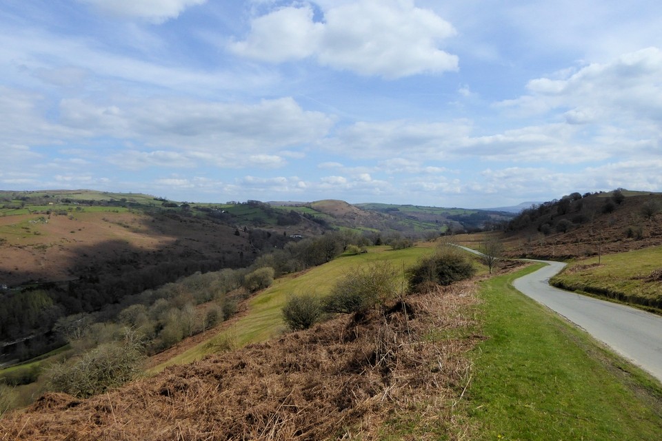
"The fleeting hour of life of those who love the hills is quickly spent, but the hills are eternal. Always there will be the lonely ridge, the dancing beck, the silent forest; always there will be the exhilaration of the summits. These are for the seeking, and those who seek and find while there is still time will be blessed both in mind and body." Alfred Wainwright
|
|