The Modern Antiquarian. Stone Circles, Ancient Sites, Neolithic Monuments, Ancient Monuments, Prehistoric Sites, Megalithic MysteriesThe Modern Antiquarian


The Devil's Churchyard

Enclosure

<b>The Devil's Churchyard</b>Posted by wysefoolImage © R A Chambers
Nearest Town:Wallingford (7km NW)
OS Ref (GB):   SU652840 / Sheet: 175
Latitude:51° 33' 2.12" N
Longitude:   1° 3' 34.38" W

Added by wysefool


Discussion Topics0 discussions
Start a topic


Show map   (inline Google Map)

Images (click to view fullsize)

Add an image Add an image
<b>The Devil's Churchyard</b>Posted by wysefool

Miscellaneous

Add miscellaneous Add miscellaneous
from Oxoniensia vol LI 1986

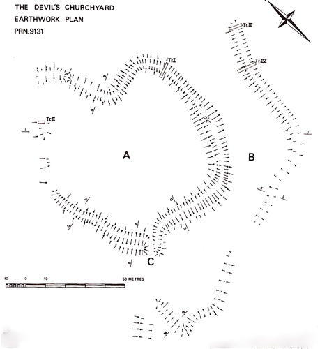
'in 1979 an earthwork enclosure known as the Devil's Churchyard was cleared of trees and undergrowth. The enclosure and associated boundary ditches have since been dated by excavation to the mid to late Iron Age.'

The site is described in the report as a heart-shaped enclosure of about 1 acre. A recent ash tree plantation has obliterated the NW earthworks.

From the ditch fills were identified bones of cattle, sheep and dog. Worked flint was also found, as was pottery which dated the site to the Iron Age.
wysefool Posted by wysefool
12th May 2007ce