The Modern Antiquarian
Log in
|
Register
Home
Latest Posts
Forums
Maps
Help
Browse Sites
News
Blog
Contributors
The Books
Select
-
Belgium
Denmark
Eire
France
Germany
Greece
Italy
The Netherlands
Norway
Portugal
Republic of Malta
Spain
Sweden
Switzerland
United Kingdom
County Meath
Rath Lugh
Rath
Rath Lugh (Rath) on The Modern Antiquarian, the UK & Ireland's most popular megalithic community website. 1 news item, 3 images, plus information on many more ancient sites nearby and across the UK & Ireland.
Image © moss
Nearest Town:
Carnew (8km ENE)
OS Ref (IE):
N939613 /
Sheet: 43
Latitude:
53° 35' 35.27" N
Longitude:
6° 34' 54.05" W
Added by
ryaner
News (1)
Images (3)
2 discussion topics
Start a topic
Show |
Hide
Web searches for Rath Lugh
Flickr
Google
Google Images
The Megalithic Portal
Bing
Stone Pages
Wikipedia
Show map
(inline Google Map)
- Sites within 20 km -
-
Lismullin (0.45km W) (8 posts)
Blundelstown (1.1km W) (0 posts)
Garlagh (1.62km WNW) (0 posts)
Cabragh (1.7km SW) (0 posts)
Collierstown (2.2km ESE) (0 posts)
Clonardran (2.28km NW) (0 posts)
The Banqueting Hall (2.29km WSW) (10 posts)
Churchyard Stones (2.4km SW) (12 posts)
The Sloping Trenches (2.41km WSW) (3 posts)
Grainne's Enclosure (2.41km WSW) (6 posts)
The Barrows (2.55km SW) (0 posts)
Rath of Synods (2.55km SW) (7 posts)
Lia Fail (2.62km SW) (23 posts)
Cormac's House (2.62km SW) (9 posts)
The Mound of Hostages (2.62km SW) (28 posts)
The Royal Enclosure (2.62km SW) (2 posts)
The King's Seat (2.62km SW) (12 posts)
Rath Laoghaire (2.68km SW) (2 posts)
Rath Maeve (3.39km SSW) (10 posts)
Gerrardstown (3.8km N) (0 posts)
Danestown Ringfort (5.08km NE) (4 posts)
Realtoge (5.39km N) (4 posts)
Ardsallagh (6.38km W) (2 posts)
Trevet (6.43km SE) (3 posts)
Dunsany (6.57km SSW) (4 posts)
Cooljohn (7.62km WSW) (2 posts)
Kingstown & Carnuff Great (7.81km NNW) (1 post)
Kilbrew (8.92km E) (3 posts)
Mooretown (8.97km S) (0 posts)
Windmill Hill (8.98km E) (0 posts)
Painestown (8.99km N) (0 posts)
Gaulstown (9.14km ENE) (3 posts)
Knockmark (9.39km S) (0 posts)
Roadmain (9.9km E) (0 posts)
Primatestown (10.02km E) (0 posts)
Piercetown (10.44km E) (0 posts)
Johnstown (10.83km N) (0 posts)
Boolies Great (10.9km ENE) (0 posts)
Culmullin (11.14km S) (4 posts)
Rossnaree (11.38km NNE) (3 posts)
Derrypatrick (11.44km SSW) (3 posts)
Newtown (11.53km E) (0 posts)
Moorepark (11.65km E) (0 posts)
Balgeeth (11.92km ENE) (2 posts)
Longford (12.63km NE) (0 posts)
Newgrange K & L (13.14km NE) (10 posts)
Newgrange Standing Stone C (13.19km NE) (6 posts)
The Great Circle (13.19km NE) (23 posts)
Gallows Hill (13.2km NNE) (0 posts)
Stackallan (13.2km NW) (2 posts)
Newgrange Tumulus A (13.25km NE) (3 posts)
Newgrange (13.27km NE) (128 posts)
Newtown (Navan Upper By.) (13.3km WSW) (3 posts)
Newgrange Tumulus B (13.31km NE) (3 posts)
Newgrange Cursus (13.35km NE) (2 posts)
Stanley Hill (13.39km N) (0 posts)
Knowth (13.4km NNE) (120 posts)
Hedgerow Stone (13.56km NE) (2 posts)
Garristown (13.7km E) (0 posts)
Gernonstown (13.8km NNW) (2 posts)
Hill of Slane Barrow (13.93km N) (1 post)
Hill of Slane Souterrain (13.94km N) (0 posts)
Iskaroon (13.95km W) (5 posts)
Gernonstown (14.14km NNW) (5 posts)
Mullagha (14.27km NW) (6 posts)
Bellewstown (14.39km ENE) (5 posts)
Dowth Mound II (14.44km NE) (0 posts)
Dowth Mound III (14.55km NE) (0 posts)
Lismahon (14.89km SSE) (1 post)
Dowth I (15.02km NE) (68 posts)
Dowth (15.03km NE) (4 posts)
Hilltown Little (15.04km ENE) (0 posts)
Monknewtown Pond (15.4km NNE) (4 posts)
Dowth II (15.5km NE) (1 post)
Dowth Mound I (15.58km NE) (0 posts)
Heathtown Henge I (15.61km ENE) (0 posts)
Monknewtown (15.67km NNE) (2 posts)
Monknewtown II (15.75km NNE) (3 posts)
Davidstown Barrow (15.8km NNW) (0 posts)
Dowth Henge (15.98km NE) (10 posts)
Rathmaiden (16.12km N) (0 posts)
Cloghalea (16.28km NE) (6 posts)
Heathtown Mound (16.42km ENE) (4 posts)
Heathtown Henge II (16.43km ENE) (5 posts)
Littlegrange (16.63km NE) (9 posts)
Micknanstown (16.68km ENE) (2 posts)
Arch Hall (16.92km WNW) (6 posts)
Fourknocks (16.95km ENE) (35 posts)
Fourknocks (17.25km ENE) (5 posts)
Townley Hall Souterrain (17.42km NE) (0 posts)
Greenanstown (17.49km ENE) (4 posts)
Herbertstown (17.68km ENE) (4 posts)
Teltown (17.75km WNW) (1 post)
Townley Hall Barrow (17.87km NE) (0 posts)
Oldbridge (18.16km NE) (7 posts)
Mellifont (18.19km NNE) (0 posts)
Westown North (18.26km E) (1 post)
Mullahteelin (18.51km ENE) (0 posts)
Mallahow (18.81km E) (0 posts)
Damastown (18.89km E) (3 posts)
Hodgetown (18.96km ENE) (0 posts)
Mullagharoy (18.99km N) (4 posts)
Rathkenny (19.06km NW) (8 posts)
Slieve Beagh (19.18km NNW) (13 posts)
The Stuck Stone (19.48km N) (0 posts)
Tullaghanoge (19.53km W) (2 posts)
Bey More (19.68km NE) (0 posts)
Knock (19.99km NW) (2 posts)
- Add -
-
Add news
Add an image
Add fieldnotes
Add folklore
Add miscellaneous
Add a link
-
Add a site
Add a nearby facility
Add an alternative name/spelling
News
Add news
Dispute over effects of M3 work
By - Adam Harvey.
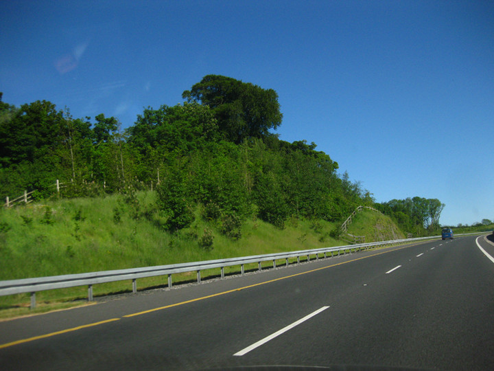
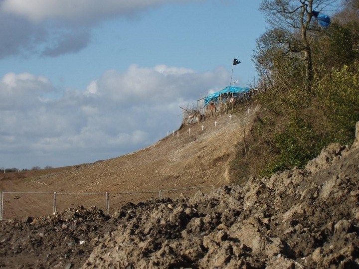
CONSTRUCTION WORK on the M3 motorway will continue at the foot of the ancient Rath Lugh promontory fort near Tara, despite claims from an NUI Galway archaeologist that the work is putting the site at risk...
continues...
Comments (0)
|
Add a comment
|
Permalink
Posted by
moss
11th March 2008ce
Images
(click to view fullsize)
Add an image

 Posted by moss