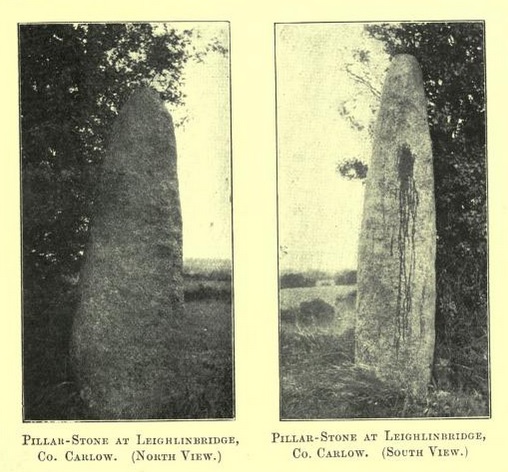
Log in
|
Register
Home
Latest Posts
Forums
Maps
Help
Browse Sites
News
Blog
Contributors
The Books
Select
-
Belgium
Denmark
Eire
France
Greece
Italy
The Netherlands
Norway
Portugal
Republic of Malta
Spain
Sweden
Switzerland
United Kingdom
County Carlow
Leighlinbridge
Standing Stone / Menhir
Leighlinbridge (Standing Stone / Menhir) on The Modern Antiquarian, the UK & Ireland's most popular megalithic community website. 3 images, plus information on many more ancient sites nearby and across the UK & Ireland.
Image © ryaner
Nearest Town:
Leighlinbridge (0km WSW)
OS Ref (IE):
S695655 /
Sheet: 61
Latitude:
52° 44' 10.3" N
Longitude:
6° 58' 15.43" W
Added by
FourWinds
Images (3)
0 discussions
Start a topic
Show |
Hide
Web searches for Leighlinbridge
Flash Earth
Flickr
Google
Google Images
The Megalithic Portal
Bing
Stone Pages
Wikipedia
Show map
(inline Google Map)
- Sites within 20 km -
-
Rathwade (1.39km E) (0 posts)
Rathoman (2.51km N) (0 posts)
Dunleckny (3.6km ESE) (1 post)
Curraghacruit (4.11km ESE) (0 posts)
Kildreenagh 2 (5.9km E) (2 posts)
Kildreenagh (6.09km E) (5 posts)
Fenniscourt (6.2km S) (7 posts)
Knockbower (7.59km ENE) (0 posts)
Kilcruit (8.6km SSE) (2 posts)
Toberbride (8.85km ESE) (0 posts)
Huntsman's Cross Road (8.9km ENE) (0 posts)
Ballinkillin (9.7km SE) (0 posts)
Ballinkillin (9.95km SE) (3 posts)
Kilgraney (10.31km SSE) (7 posts)
Tomdarrach (11.9km SSE) (2 posts)
Browne's Hill (12.33km NNE) (26 posts)
Ballyellin and Tomdarragh (12.68km S) (3 posts)
Busherstown (12.96km NE) (0 posts)
Killenora (13km NE) (0 posts)
Glenoge (13.32km NE) (0 posts)
Bennekerry (13.51km NE) (0 posts)
Freestone Hill (14km SW) (3 posts)
Myshall (14.07km E) (3 posts)
Ballinasilloge (14.09km SE) (11 posts)
Clarabricken (14.26km SW) (0 posts)
Killoughternane/Knockscur (14.39km ESE) (4 posts)
Killoughternane (14.39km ESE) (0 posts)
Kilmurray (14.46km ENE) (0 posts)
Knockscur (14.59km ESE) (0 posts)
Coolasnaghta (14.74km ESE) (2 posts)
Spahill (14.92km SE) (2 posts)
Knockbrack Cairns (15.14km E) (0 posts)
Sragh (15.27km E) (0 posts)
Knockbrack (15.42km E) (2 posts)
Mount Leinster (15.45km ESE) (0 posts)
Cloch An Phoill (15.56km ENE) (5 posts)
Ardristan 2 (15.69km ENE) (0 posts)
Ardristan (15.75km ENE) (9 posts)
Knockbarragh (16.02km E) (0 posts)
The Nine Stones (16.31km ESE) (1 post)
Ballynoe (16.36km ENE) (0 posts)
Aghade (16.51km ENE) (1 post)
Ullard (17.42km SSE) (5 posts)
Crannagh (17.45km ESE) (0 posts)
Rathglass (17.77km ENE) (0 posts)
Straboe (18.28km NE) (0 posts)
Craans (18.54km ENE) (2 posts)
Knockmore (18.62km SE) (2 posts)
Crannagh (18.69km ESE) (3 posts)
Kyle (18.84km SE) (0 posts)
Tinncarrig (19.51km SE) (5 posts)
Kilmissan (19.73km SE) (0 posts)
Rathgeran (19.78km SE) (7 posts)
Rathgeran Hill (19.96km SE) (8 posts)
- Add -
-
Add news
Add an image
Add fieldnotes
Add folklore
Add miscellaneous
Add a link
-
Add a site
Add a nearby facility
Add an alternative name/spelling
Images
(click to view fullsize)
Add an image