The Modern Antiquarian
Log in
|
Register
Home
Latest Posts
Forums
Maps
Help
Browse Sites
News
Blog
Contributors
The Books
Select
-
Belgium
Denmark
Eire
France
Germany
Greece
Italy
The Netherlands
Norway
Portugal
Republic of Malta
Spain
Sweden
Switzerland
United Kingdom
County Carlow
Clonmore
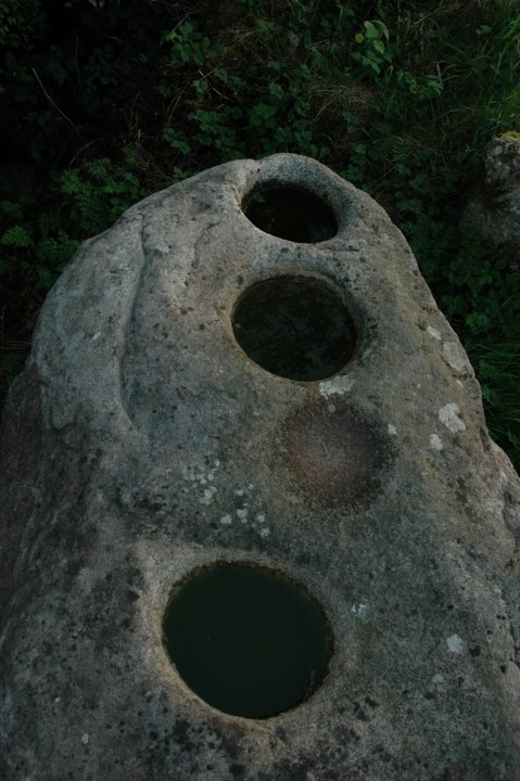
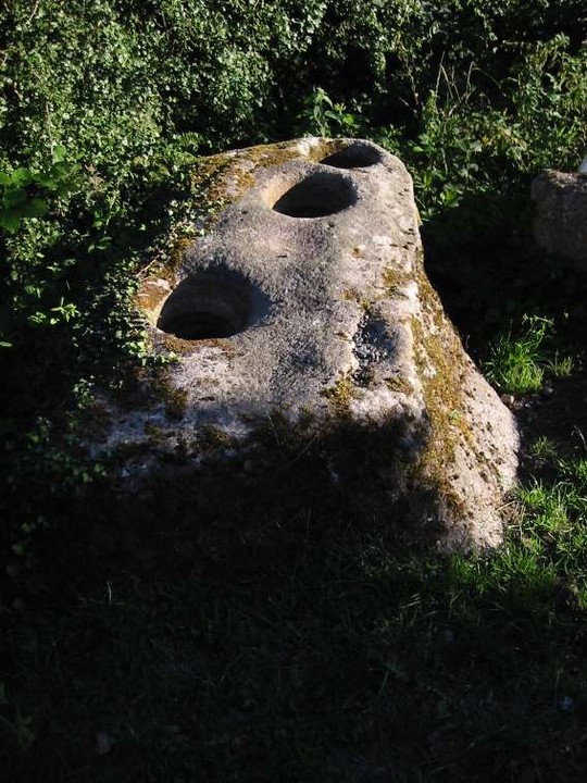
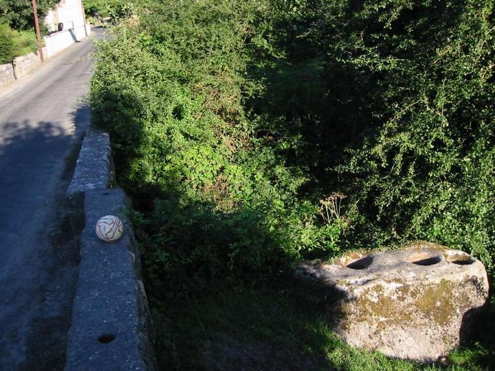
Bullaun Stone
Clonmore (Bullaun Stone) on The Modern Antiquarian, the UK & Ireland's most popular megalithic community website. 3 images, plus information on many more ancient sites nearby and across the UK & Ireland.
Image © ryaner
Nearest Town:
Hacketstown (4km N)
OS Ref (IE):
S963761 /
Sheet: 62
Latitude:
52° 49' 38.35" N
Longitude:
6° 34' 16.1" W
Added by
FourWinds
Images (3)
1 discussion topic
Start a topic
Show |
Hide
Web searches for Clonmore
Flickr
Google
Google Images
The Megalithic Portal
Bing
Stone Pages
Wikipedia
Show map
(inline Google Map)
- Sites within 20 km -
-
Seskin (3.1km S) (0 posts)
Killabeg Stone (4.55km SSW) (0 posts)
Tombeagh (5.98km NW) (2 posts)
Knockballystine (5.98km W) (0 posts)
Williamstown (6.2km WNW) (7 posts)
Haroldstown (6.43km W) (38 posts)
Rath East (6.46km WSW) (0 posts)
Rath Gael (6.73km WSW) (17 posts)
Aghowle Lower (7.29km SSW) (3 posts)
Tobinstown (7.3km W) (0 posts)
Aghowle Upper (7.99km SSW) (5 posts)
Moylisha (9.16km SSW) (8 posts)
Kilmagarvoge (9.34km W) (1 post)
Patrickswell (9.72km WNW) (0 posts)
Humewood Castle (9.9km NNW) (4 posts)
Ballynavortha (10.35km SW) (2 posts)
Blacklion (10.66km SW) (0 posts)
Rathglass (11.01km WSW) (0 posts)
Rathmore (11.12km W) (0 posts)
Coolroe (11.47km SW) (3 posts)
Preban (11.82km ENE) (10 posts)
Craans (11.92km SW) (6 posts)
Ardattin (12.14km SW) (3 posts)
Carrig Mountain (12.2km NNW) (0 posts)
Muckduff Upper 2/Carrig Mountain (12.3km NNW) (4 posts)
Ballynoe (12.77km WSW) (1 post)
Keadeen standing stone 2 (12.82km NNW) (2 posts)
Muckduff Upper (12.9km NNW) (5 posts)
Ardristan (12.97km WSW) (11 posts)
Ardristan 2 (13.03km WSW) (0 posts)
Colvinstown (13.22km NNW) (3 posts)
Colvinstown Upper II (13.23km NW) (2 posts)
Colvinstown Upper (13.36km NW) (4 posts)
Straboe (13.37km W) (0 posts)
Cloch An Phoill (Aghade) (13.39km WSW) (9 posts)
Colvinstown Upper III (13.42km NW) (2 posts)
Aghade (13.44km WSW) (4 posts)
Boleycarrigeen (13.47km NNW) (54 posts)
Keadeen (13.6km NNW) (3 posts)
Keadeen (13.61km NNW) (0 posts)
Keadeen (13.71km NNW) (3 posts)
Keadeen Cursus (13.72km NNW) (5 posts)
Kilranelagh (13.8km NW) (0 posts)
Keadeen Mountain (13.82km NNW) (4 posts)
Carnew (14.24km SE) (3 posts)
Kilranelagh Graveyard (14.42km NW) (6 posts)
Lybagh (14.44km NNE) (0 posts)
Buckstown (14.98km ESE) (0 posts)
Rathcoran Hillfort (15.21km NW) (3 posts)
Baltinglass Hill Cairn - Standing Stone (15.21km NW) (2 posts)
Baltinglass Hill - Cairn (15.21km NW) (2 posts)
Baltinglass Hill - Standing Stone (15.21km NW) (1 post)
Baltinglass Hill - Tombs (15.21km NW) (19 posts)
Brusselstown Ring (15.24km NNW) (21 posts)
Baltinglass Hill (15.3km NW) (2 posts)
Baltinglass Hill 'Basin' Stone (15.35km NW) (3 posts)
Foxcover (15.51km ESE) (0 posts)
Kilmurray (15.74km SW) (0 posts)
Spinans Hill (15.74km NW) (0 posts)
Clonegall (16.01km SSW) (0 posts)
Tuckmill Hill (16.02km NW) (3 posts)
Coan (16.09km N) (0 posts)
Glenoge (16.25km WSW) (2 posts)
Sragh (16.29km SW) (0 posts)
Killenora (17.05km WSW) (0 posts)
Eadestown North (17.27km NW) (0 posts)
Hughstown (17.64km WNW) (4 posts)
Tinoran Hill (18.08km WNW) (0 posts)
Bolany (18.09km ESE) (0 posts)
Croghan Middle (18.12km E) (4 posts)
Clonamore Upper (18.12km ESE) (0 posts)
The Ballintruer Long Stone (18.17km NW) (0 posts)
Ballintruer More (18.17km NW) (6 posts)
Leitrim (18.18km N) (7 posts)
Knockbarragh (18.28km SW) (0 posts)
The Druid's Stone (18.34km ENE) (1 post)
Busherstown (18.44km WSW) (0 posts)
Shrule (18.54km SE) (0 posts)
Monbay Upper (18.66km SE) (0 posts)
Castleruddery (18.77km NNW) (48 posts)
Bennekerry (18.83km W) (0 posts)
Kelshamore (18.85km NNW) (5 posts)
Knickeen (18.88km N) (9 posts)
Brittas II (18.92km N) (2 posts)
Brittas III (18.92km N) (4 posts)
Brittas V (18.92km N) (3 posts)
Brittas IV (18.92km N) (7 posts)
Brittas (18.92km N) (7 posts)
Knockbrack (18.94km SW) (2 posts)
Castleruddery Lower (18.97km NW) (4 posts)
Fananierin (19.06km NE) (5 posts)
Knockbrack Cairns (19.13km SW) (0 posts)
Slievefoore (19.34km E) (10 posts)
Huntsman's Cross Road (19.89km WSW) (0 posts)
- Add -
-
Add news
Add an image
Add fieldnotes
Add folklore
Add miscellaneous
Add a link
-
Add a site
Add a nearby facility
Add an alternative name/spelling
Images
(click to view fullsize)
Add an image
 Image © ryaner