The Modern Antiquarian. Stone Circles, Ancient Sites, Neolithic Monuments, Ancient Monuments, Prehistoric Sites, Megalithic MysteriesThe Modern Antiquarian


Sandy Lodge Promontory Fort

Hillfort

<b>Sandy Lodge Promontory Fort</b>Posted by juameiImage © © Environment Agency copyright and/or database right 2015.
Nearest Town:Biggleswade (3km SSE)
OS Ref (GB):   TL187476 / Sheet: 153
Latitude:52° 6' 48.57" N
Longitude:   0° 15' 58.8" W

Added by Rhiannon


Discussion Topics0 discussions
Start a topic


Show  |  Hide
Web searches for Sandy Lodge Promontory Fort
Show map   (inline Google Map)

Images (click to view fullsize)

Add an image Add an image
<b>Sandy Lodge Promontory Fort</b>Posted by juamei

Miscellaneous

Add miscellaneous Add miscellaneous
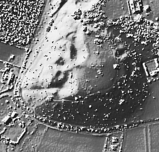
The Sandy Lodge fort would have been first occupied in the very early Iron Age (according to information on the 'Magic' schedule). It probably just had a wooden palisade rather than a more hefty earthen bank and ditch. Now the area has been disturbed by quarrying in places, but as the fort used a natural promontory, it might not be too difficult to work out where it might have been . It would only have been 150m from the Galley Hill fort, but this was probably used later? It's a nice place to visit (nature trails go through this area - it is part of the RSPB headquarters)and you can get a feel for the view its inhabitants would have had, out over the flat countryside below. Rhiannon Posted by Rhiannon
29th December 2006ce
Edited 30th December 2006ce