The Modern Antiquarian
Log in
|
Register
Home
Latest Posts
Forums
Maps
Help
Browse Sites
News
Blog
Contributors
The Books
Select
-
Belgium
Denmark
Eire
France
Germany
Greece
Italy
The Netherlands
Norway
Portugal
Republic of Malta
Spain
Sweden
Switzerland
United Kingdom
Scotland
Dumfries and Galloway
Bombie
Bombie 2
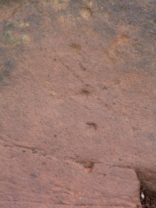
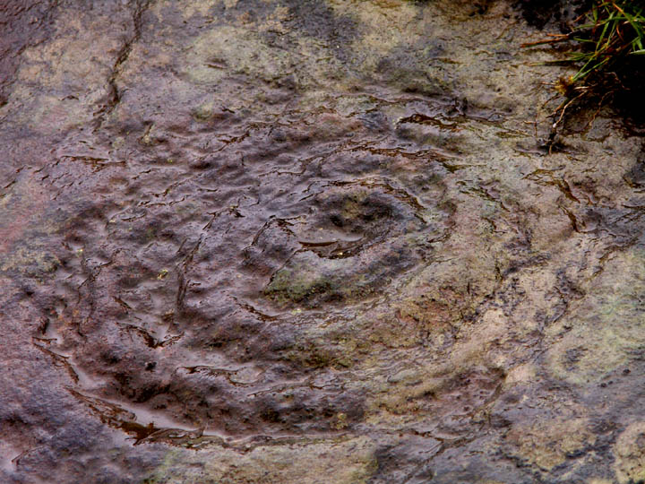
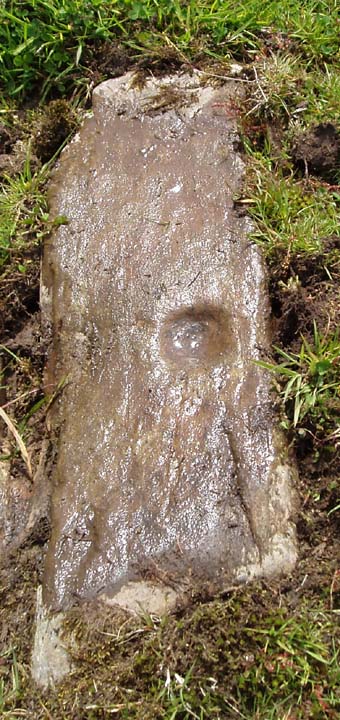
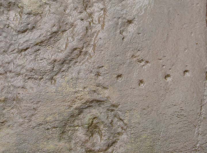
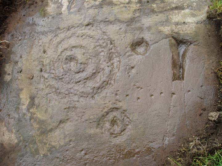
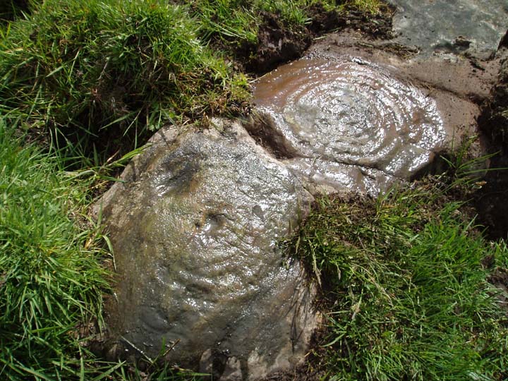
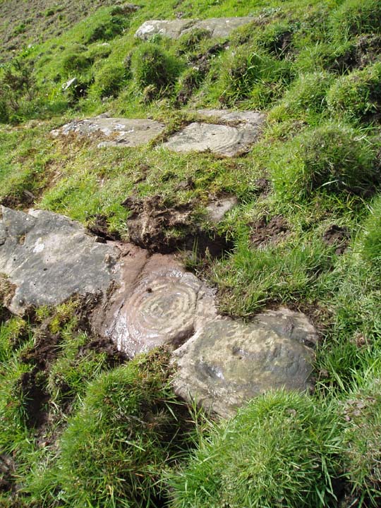
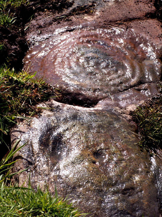
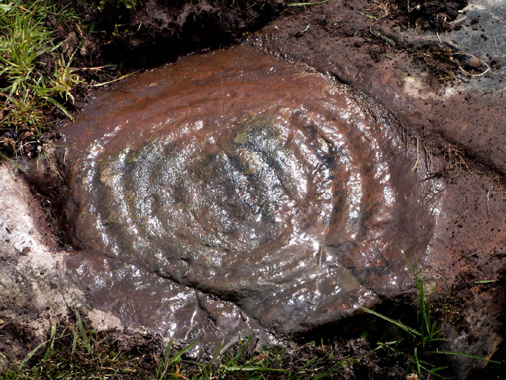
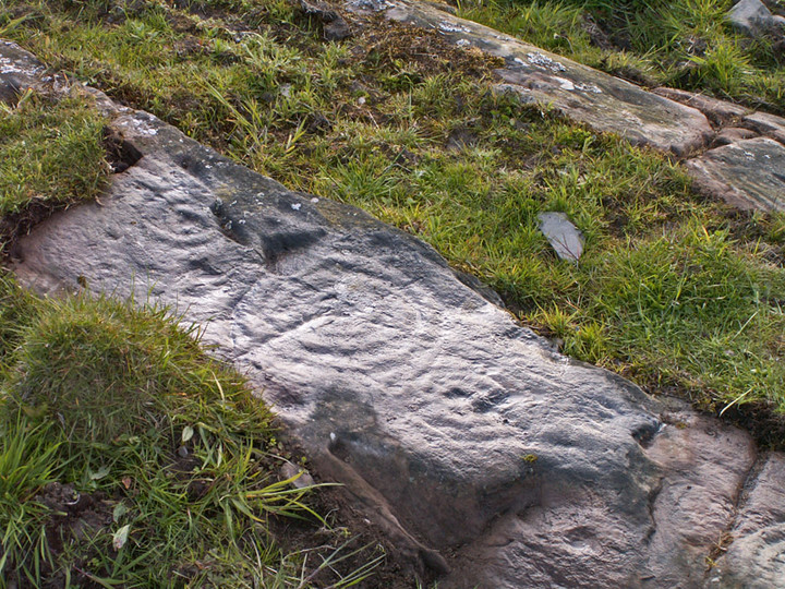
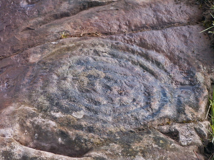
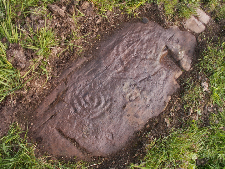
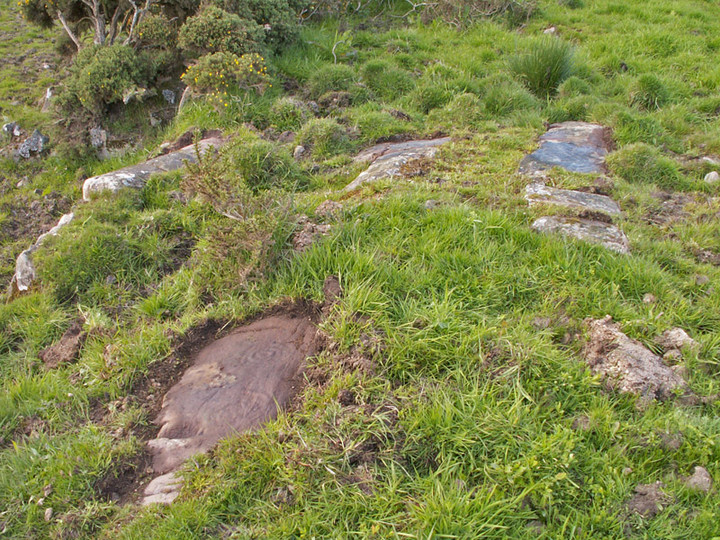
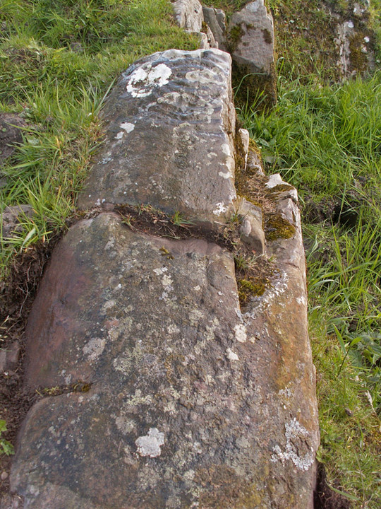
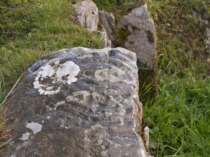
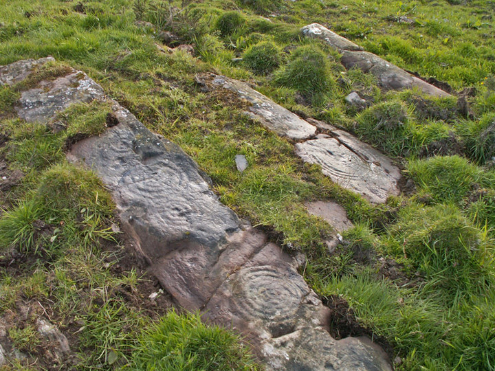
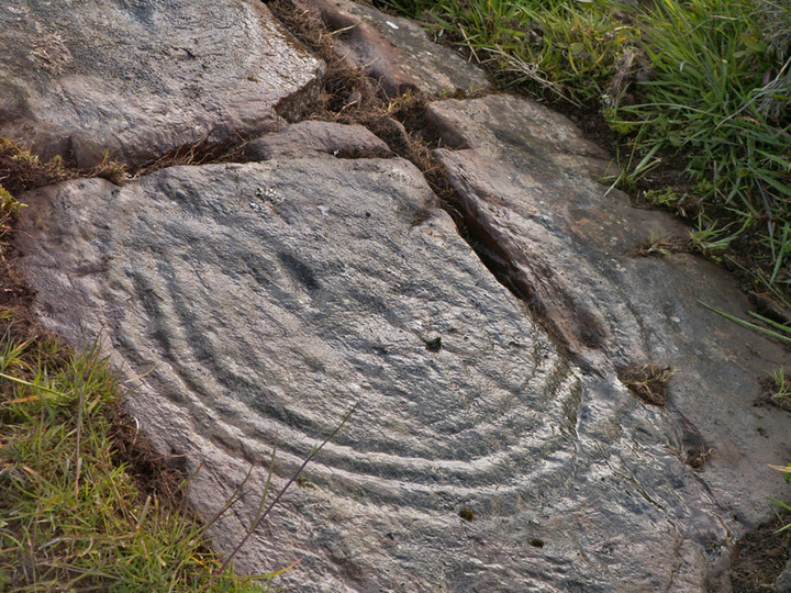
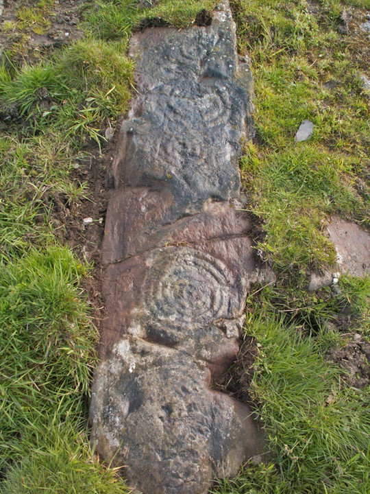
Cup and Ring Marks / Rock Art
Bombie 2 (Cup and Ring Marks / Rock Art) on The Modern Antiquarian, the UK & Ireland's most popular megalithic community website. 18 images, plus information on many more ancient sites nearby and across the UK & Ireland.
Image © pebblewolf
Nearest Town:
Kirkcudbright (4km W)
OS Ref (GB):
NX723500 /
Sheets: 83, 84
Latitude:
54° 49' 41.97" N
Longitude:
3° 59' 17.31" W
Added by
rockartwolf
Images (18)
0 discussions
Start a topic
Show |
Hide
Web searches for Bombie 2
Flickr
Google
Google Images
MAGIC
The Megalithic Portal
Bing
Stone Pages
Streetmap.co.uk
Wikipedia
Show map
(inline Google Map)
- Sites within 20 km -
-
Bombie 1 (0.1km SSE) (5 posts)
Bombie 5 (0.2km SSE) (0 posts)
Bombie 3 (0.28km ESE) (9 posts)
Bombie (0.36km ESE) (3 posts)
Bombie 4 (0.42km ESE) (3 posts)
Castlecreavie (0.8km SSE) (9 posts)
Castlecreavie (1.04km SE) (15 posts)
Castlecreavie Dun (1.04km SE) (5 posts)
Newlaw Hill 1 (1.48km ESE) (17 posts)
Newlaw Hill 2 (1.48km ESE) (3 posts)
Newlaw Hill 3 (1.55km ESE) (19 posts)
Galtway 5 (1.62km SW) (6 posts)
High Banks (1.78km SW) (46 posts)
Galtway 7 (1.91km SW) (2 posts)
Galtway (2.06km SW) (5 posts)
Galtway 18 (2.33km SW) (6 posts)
Culdoach (2.91km WNW) (22 posts)
High Grange 1 (3.39km SW) (13 posts)
High Grange 2 (3.53km SW) (0 posts)
Milton (3.54km SW) (89 posts)
Townhead (3.89km SW) (49 posts)
Grange 3 (4.29km SW) (11 posts)
Blackhill Cottage (4.52km SW) (5 posts)
Grange 1 (4.53km SW) (4 posts)
Grange 2 (4.53km WSW) (3 posts)
Dunrod (4.84km SW) (2 posts)
Nether Linkens (5.37km NNE) (9 posts)
Drummore (5.38km SW) (12 posts)
Drummore Castle (5.54km SW) (5 posts)
Torrs 1 & 2 (5.85km SW) (12 posts)
Knockshinnie (5.94km SW) (11 posts)
Knockshinnie 2 (6.23km SW) (8 posts)
Torrs 7 (6.29km SW) (2 posts)
Torrs 4 (6.36km SW) (8 posts)
Torrs 3b (6.43km SW) (1 post)
Park of Tongland (6.45km NW) (9 posts)
Torrs 3 (6.5km SW) (12 posts)
Torrs (6.51km SW) (8 posts)
Balmae 35 (6.67km SW) (3 posts)
Torrs 10 (6.78km SW) (2 posts)
Park of Tongland (7.02km NW) (1 post)
Ingle Stone (7.12km W) (4 posts)
High Nunton (7.18km WSW) (5 posts)
Arden Fort (7.53km W) (7 posts)
The Doon (Twynholm) (7.63km W) (7 posts)
Senwick 1 (8.26km WSW) (5 posts)
Clauchendolly (8.45km WSW) (54 posts)
Clash (8.65km WSW) (11 posts)
Borgue (8.83km WSW) (6 posts)
Auchenhay (8.86km W) (2 posts)
Senwick 4 (8.92km WSW) (8 posts)
Slagnaw (9.04km NNE) (3 posts)
White Cairn, Gelston (9.09km NNE) (4 posts)
Big Airds Hill (9.24km E) (0 posts)
Brighouse Standing Stone (9.36km WSW) (6 posts)
Little Airds Hill (9.82km E) (0 posts)
Lodge Of Kelton Farm (11.18km N) (9 posts)
Giant's Dike (11.22km NW) (7 posts)
Glengap House (11.59km WNW) (1 post)
Tongue Croft (12.06km WSW) (18 posts)
Carlingwark Loch (12.5km NNE) (7 posts)
Torrs Hill (12.69km NNE) (1 post)
Court Hill (12.75km NE) (0 posts)
Castle Haven (13.03km WSW) (6 posts)
Ernespie Standing Stones (14.16km NNE) (10 posts)
Harper's Hill (14.51km W) (10 posts)
Trusty's Hill (14.64km W) (13 posts)
Rutherford's Well (15.19km W) (7 posts)
Rutherford's Witnesses (16.05km W) (6 posts)
Lagganmullan 9 (16.51km W) (6 posts)
Lagganmullan 10 (16.51km W) (3 posts)
Lagganmullan 8 (16.51km W) (11 posts)
Lagganmullan 1 (16.57km W) (0 posts)
Newbarns South (16.58km ENE) (13 posts)
Colvend (16.58km ENE) (1 post)
Newbarns North (16.58km ENE) (15 posts)
Lagganmullan House (16.61km W) (3 posts)
Lagganmullan 2 (16.76km W) (6 posts)
Lagganmullan 4 (16.95km W) (13 posts)
Lagganmullan 3 (16.98km W) (4 posts)
Lagganmullan 7a (16.99km W) (5 posts)
Lagganmullan 6 (16.99km W) (0 posts)
Lagganmullan 7b (16.99km W) (3 posts)
Lagganmullan 7c (16.99km W) (2 posts)
Lagganmullan 7 (16.99km W) (2 posts)
Lagganmullan 7d (16.99km W) (5 posts)
Newton Farm (17.04km W) (1 post)
Lagganmullan 5 (17.11km W) (2 posts)
Newton Farm (17.29km W) (3 posts)
Newton Farm Burial Chamber (17.32km W) (12 posts)
Mossyard 6 (17.34km W) (7 posts)
Upper Newton 3 (17.49km W) (4 posts)
Upper Newton 2 (17.52km W) (5 posts)
Mossyard 1 (17.77km W) (9 posts)
Mossyard (17.79km W) (21 posts)
Whiteside (17.82km W) (3 posts)
Laggan Farm (17.89km W) (3 posts)
Upper Newton 1 (17.99km W) (4 posts)
Upper Newton 4 (18.09km W) (0 posts)
Redcastle (18.29km NE) (6 posts)
High Auchenlarie (18.6km W) (20 posts)
High Auchenlarie (18.64km W) (8 posts)
Kirkclaugh (18.68km W) (2 posts)
Kirkclaugh (19.28km W) (1 post)
Cairnharrow (19.45km W) (18 posts)
Bardristane 3 (19.54km W) (3 posts)
Bardristane 4 (19.64km W) (6 posts)
Bardristane 1 (19.82km W) (5 posts)
Cairnharrow (19.88km W) (11 posts)
- Facilities within 20 km -
-
Newton Farm (Camping Site: 17.1 km W)
- Add -
-
Add news
Add an image
Add fieldnotes
Add folklore
Add miscellaneous
Add a link
-
Add a site
Add a nearby facility
Add an alternative name/spelling
Images
(click to view fullsize)
Add an image
 Image © pebblewolf