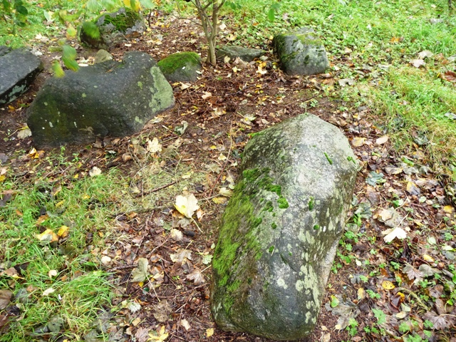
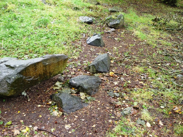
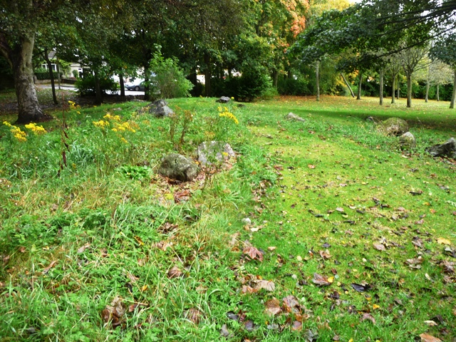
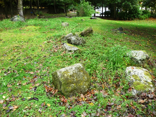
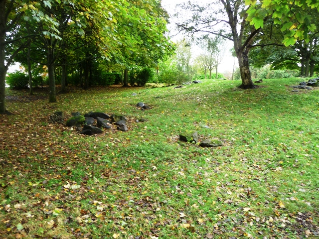
Log in
|
Register
Home
Latest Posts
Forums
Maps
Help
Browse Sites
News
Blog
Contributors
The Books
Select
-
Belgium
Denmark
Eire
France
Greece
Italy
The Netherlands
Norway
Portugal
Republic of Malta
Spain
Sweden
Switzerland
United Kingdom
Scotland
Aberdeenshire
Cults Stone Circle (Site of)
Stone Circle
Cults Stone Circle (Site of) (Stone Circle) on The Modern Antiquarian, the UK & Ireland's most popular megalithic community website. The site also contains a vast wealth of information on many more ancient sites across the UK & Ireland.
No image available
Nearest Town:
Aberdeen (5km NE)
OS Ref (GB):
NJ894035 /
Sheet: 38
Latitude:
57° 7' 20.41" N
Longitude:
2° 10' 30.3" W
Added by
Chris
Miscellaneous (1)
0 discussions
Start a topic
Show |
Hide
Web searches for Cults Stone Circle (Site of)
Flash Earth
Flickr
Google
Google Images
MAGIC
The Megalithic Portal
Bing
Stone Pages
Streetmap.co.uk
Wikipedia
Show map
(inline Google Map)
- Sites within 20 km -
-
Cairnlee Cairn (1.3km WSW) (11 posts)
Tollohill Wood (2.79km E) (6 posts)
Westfield (3.43km WSW) (6 posts)
Blacktop (3.6km W) (5 posts)
Binghill East (3.98km WSW) (6 posts)
Binghill West (4.04km WSW) (9 posts)
Binghill (4.07km WSW) (19 posts)
Blue Hill (Banchory-Devenick) (4.3km ESE) (7 posts)
Kincorth Hill (4.68km E) (4 posts)
Crab Stane (4.72km ENE) (1 post)
The Langstane (Aberdeen) (4.82km ENE) (5 posts)
West Hatton (5.54km WNW) (6 posts)
Hilton School Langstane (5.61km NE) (12 posts)
Cat Cairn (5.69km E) (11 posts)
Blaikiewell (5.71km SW) (4 posts)
Cat Cairn 2 (5.8km E) (8 posts)
Craighead (6.06km SE) (7 posts)
Barons Cairn (6.28km ENE) (8 posts)
Tullos Hill (6.5km ENE) (10 posts)
Cairnwell (6.6km S) (10 posts)
Tillydrone (6.84km NE) (8 posts)
Crabs Cairn (6.88km ENE) (7 posts)
Altries (smaller ring cairns) (6.92km SW) (4 posts)
Altries (6.94km SW) (4 posts)
Aquhorthies (7.19km SSE) (16 posts)
Stranog Hill 2 (7.32km SSW) (3 posts)
Stranog Hill 1 (7.4km SSW) (4 posts)
Old Bourtreebush (7.46km SSE) (9 posts)
Standingstones (7.59km SW) (6 posts)
Standingstones Kerb Cairn (7.68km SW) (2 posts)
Tulloch Boundary Marker 33 (7.8km WNW) (3 posts)
Broad Havens (8.06km ESE) (11 posts)
Hilton of Cairngrassie (8.26km SSE) (3 posts)
Auchinclech (8.28km W) (10 posts)
South Auchinclech (8.4km WNW) (5 posts)
Souterhill (8.56km W) (6 posts)
Whitestripes (8.84km NNE) (1 post)
Hill of Keir (9.01km W) (7 posts)
Woods Of Cairnie 1 (9.06km W) (6 posts)
Woods Of Cairnie 2 (9.37km W) (6 posts)
Springhill (9.68km W) (13 posts)
Bishop's Lands (9.99km WNW) (8 posts)
Tertowie (10.04km WNW) (5 posts)
Auchronie (10.16km W) (4 posts)
Tyrebagger (10.39km NW) (57 posts)
Little Clinterty (10.6km WNW) (4 posts)
Mundurno (10.62km NNE) (3 posts)
Cullerie (10.89km W) (32 posts)
The Gouch Stone (destroyed?) (11.05km WNW) (1 post)
The Drum Stone (11.27km W) (5 posts)
Blue Hill (11.88km NW) (7 posts)
The Slacks (12.07km NW) (4 posts)
The Slacks (12.08km NW) (11 posts)
Mimrikin's Clump (12.71km NW) (6 posts)
Cairntradlin (12.88km WNW) (3 posts)
Finnercy (12.91km W) (8 posts)
Clune Hill (13.08km SW) (28 posts)
Clune Wood (13.11km SW) (2 posts)
Kinellar Kirkyard (13.12km WNW) (12 posts)
Gouk Stone, Kinaldie (13.12km NW) (5 posts)
Allochie (13.14km SSW) (6 posts)
Northward (13.16km SW) (7 posts)
Cantlayhills (13.25km S) (1 post)
South Fornet (13.38km W) (8 posts)
Donald's Hillock (13.67km NW) (6 posts)
Little Fornet (13.86km W) (7 posts)
Braedale (13.91km NNW) (11 posts)
Home Farm Of Potterton (14.02km NNE) (7 posts)
Mill of Fintray Cursus/ Multiple Stone Rows / Avan (14.07km NW) (1 post)
Elsick Mounth (14.11km SW) (6 posts)
Kempstone Hill (14.11km S) (3 posts)
Mote Hill (14.12km NW) (7 posts)
Temple Stones, Millden (14.16km NNE) (5 posts)
Raedykes (14.28km SSW) (13 posts)
Ferneybrae (14.37km WNW) (4 posts)
Highland Wood Croft (14.52km NNW) (9 posts)
Auquhollie Stone (14.52km SW) (14 posts)
Monykebbuck (14.85km NNW) (7 posts)
Chapel of Elrick (14.96km NNW) (6 posts)
Midmill (15.23km WNW) (11 posts)
Larrick (15.36km WNW) (6 posts)
Hare Cairn (15.38km NNE) (6 posts)
Hill of Tuack (15.39km WNW) (12 posts)
Newton Wood (15.41km NW) (1 post)
Waterside (15.62km WNW) (9 posts)
Nether Corskie (15.68km W) (9 posts)
Leylodge School 2 (15.7km W) (4 posts)
South Leylodge (15.71km W) (4 posts)
Hillhead Of Suttie (15.74km WNW) (5 posts)
Leylodge School (16.05km W) (4 posts)
South Leylodge (16.07km W) (20 posts)
Cairn-Mon-Earn (16.1km SW) (5 posts)
Hare Stone (16.19km NNE) (5 posts)
Wester Echt (16.2km W) (10 posts)
Kintore Golf Club (16.25km WNW) (8 posts)
Greenlands (16.42km WNW) (6 posts)
Glenton Hill (16.47km SSW) (5 posts)
The Knock (16.49km W) (4 posts)
Nether Lauchentilly (16.75km W) (5 posts)
Cairnfauld (16.81km WSW) (8 posts)
Upper Broomhill (17.07km W) (4 posts)
Peat Hill (17.1km NW) (8 posts)
Orde's Cairn (17.11km W) (4 posts)
Barmekin Hill (17.12km W) (24 posts)
Peat Hill (17.18km NW) (4 posts)
Spurryhillock (17.53km SSW) (2 posts)
Lumphanan Hill (17.74km W) (5 posts)
Balbridie (17.74km WSW) (2 posts)
Sunhoney (17.86km W) (56 posts)
Old Kinnernie (17.94km W) (6 posts)
Cairnshee Woods (18.15km WSW) (7 posts)
Cairnhall (18.16km WNW) (14 posts)
Braeneil (18.52km W) (3 posts)
Fetteresso (18.55km SSW) (2 posts)
Clovenstone Farm (19.03km WNW) (5 posts)
Camies Stone (19.06km WNW) (6 posts)
John Bells Stone (19.53km W) (3 posts)
Dunnottar Castle (19.61km S) (7 posts)
Broomend (19.63km WNW) (6 posts)
Midmar Kirk (19.64km W) (62 posts)
Loch Of Leys (19.71km WSW) (4 posts)
Tilquhillie (19.76km WSW) (11 posts)
Broomend of Crichie (19.82km WNW) (54 posts)
Bruce's Camp (19.89km WNW) (5 posts)
Balgorkar (19.97km W) (25 posts)
- Facilities within 20 km -
-
Marischal Museum (Museum: 5.7 km NE)
Maryculter House (Hotel: 6.5 km SW)
- Add -
-
Add news
Add an image
Add fieldnotes
Add folklore
Add miscellaneous
Add a link
-
Add a site
Add a nearby facility
Add an alternative name/spelling
Miscellaneous
Add miscellaneous
On some open land in Friarsfield Road stands the site of this circle. Approx 6 stones still remain on the site, but RCAHMS are of the opinion that they are definitely not in-situ, and may not even have belonged to the circle.
Comments (0)
|
Add a comment
|
Permalink
Posted by
Chris
9th October 2006ce