The Modern Antiquarian
Log in
|
Register
Home
Latest Posts
Forums
Maps
Help
Browse Sites
News
Blog
Contributors
The Books
Select
-
Belgium
Denmark
Eire
France
Germany
Greece
Italy
The Netherlands
Norway
Portugal
Republic of Malta
Spain
Sweden
Switzerland
United Kingdom
Wales
Carmarthenshire
Cefn Gwernffrwd Complex
Cefn Gwernffrwd
Cairn(s)
Cefn Gwernffrwd (Cairn(s)) on The Modern Antiquarian, the UK & Ireland's most popular megalithic community website. 1 image, 1 fieldnote, plus information on many more ancient sites nearby and across the UK & Ireland.
Image © nix stewart
Nearest Town:
Llanwrtyd Wells (14km E)
OS Ref (GB):
SN737493 /
Sheets: 146, 147
Latitude:
52° 7' 37.5" N
Longitude:
3° 50' 42.86" W
Added by
tuesday
Images (1)
Fieldnotes (1)
0 discussions
Start a topic
Show |
Hide
Web searches for Cefn Gwernffrwd
Flickr
Google
Google Images
The Megalithic Portal
Bing
Stone Pages
Streetmap.co.uk
Wikipedia
Show map
(inline Google Map)
- Sites within 20 km -
-
Cefn Gwenffrwd (0km N) (5 posts)
Cefn Gwernffrwd (0km N) (5 posts)
Cefn Gwernffrwd Complex (0km N) (15 posts)
Cnwch Eithinog (1.93km ENE) (9 posts)
Cnwch Eithinog (2.02km ENE) (10 posts)
Cefn Gwenffrwd (2.76km ESE) (3 posts)
Poppy Stone (3.17km ESE) (3 posts)
Carn Penrhiwllwydog (3.35km N) (8 posts)
Bryn Gwyddel (3.43km NNW) (8 posts)
Crug Siarls (3.87km WSW) (10 posts)
Crugiau Merched (4.08km SSW) (22 posts)
Maen Bach (4.35km S) (4 posts)
Pen-y-Gurnos (4.45km ENE) (10 posts)
Maen Hir (4.6km S) (3 posts)
Pen y Corn (4.77km W) (10 posts)
Gelli (4.87km ESE) (9 posts)
Carn Saith-Wraig (5.01km NE) (13 posts)
Ty Newydd Stone Row (5.02km ESE) (4 posts)
Ty Newydd (5.1km ESE) (7 posts)
Bryn y Gorlan (5.56km N) (25 posts)
Graig-wen (Llanddewi Brefi) (5.62km W) (6 posts)
Garn, Banciau Duon (5.8km WNW) (10 posts)
Carn Wen (Cynwyl Gaeo) (5.85km WSW) (11 posts)
Carn Fawr (Cynwyl Gaeo) (6.86km W) (12 posts)
Cnwch Mawr (Llanddewi Brefi) (6.89km WNW) (10 posts)
Cerrig Cewri (6.99km E) (9 posts)
Bryn Mawr (7.15km W) (8 posts)
Carn Twrch (7.26km E) (7 posts)
Carn Wen (7.32km E) (2 posts)
Craig Twrch (Cynwyl Gaeo) (7.45km WSW) (10 posts)
Banc Ty-hen (7.5km WSW) (9 posts)
Bryn Rhudd (7.62km WNW) (1 post)
Banc Maes-yr-haidd (7.63km SSW) (10 posts)
Carreg Samson (7.64km WNW) (1 post)
Crug (7.82km W) (12 posts)
Bryn-Poeth-Uchaf North (7.94km ESE) (17 posts)
Bryn Rhudd (8.04km WNW) (22 posts)
Cerrig Cynant (8.3km ESE) (24 posts)
Bryn Poeth Uchaf South (8.37km ESE) (21 posts)
Garn Fawr (Tregaron) (8.37km NW) (10 posts)
Nant Gwyn (Llanfair-ar-y-Bryn) (8.4km ESE) (8 posts)
Carreg Garn Fawr (8.4km ESE) (19 posts)
Garn Felen (Llanddewi Brefi) (8.45km NW) (0 posts)
Banc-y-Gwyngoed (8.66km WNW) (10 posts)
Nant-y-Ffrwd (8.67km N) (4 posts)
Esgair Fraith (Cynwyl Gaeo) (8.9km WSW) (11 posts)
Carreg y Bwci (9.17km WSW) (23 posts)
Nant-y-Maen (9.33km N) (7 posts)
Esgair Garn, Llanddewi Abergwesyn (9.36km ENE) (9 posts)
Cefn Cerrig (9.51km NNE) (14 posts)
Blaen Camddwr (9.7km N) (5 posts)
Esgair Perfedd (10.08km N) (7 posts)
Moelau (10.24km NNW) (8 posts)
Bryn Cosyn (10.24km N) (4 posts)
Esgair Gerwyn (10.37km NE) (4 posts)
Castell Rhyfel (10.57km NNW) (13 posts)
Groes Fawr (10.59km NNW) (6 posts)
Pen Banc (10.98km W) (0 posts)
Y Garn (Garn Gron) (11.37km NNW) (11 posts)
Bryn Goleu (11.47km WSW) (6 posts)
Carreg Pumsaint (11.49km SW) (4 posts)
Caer Maurice (11.51km WSW) (12 posts)
Dolaucothi Gold Mines (11.62km SW) (4 posts)
Hirfaen Gwyddog (11.63km WSW) (18 posts)
Mynydd Pen-y-Fal (Sugar Loaf) (11.72km E) (12 posts)
Garn Gron (11.75km NNW) (17 posts)
Berrisbrook (11.87km S) (3 posts)
Castell Tregaron. Sunnyhill wood camp (11.96km NW) (13 posts)
Nant Cwm Dwfn (12.11km ENE) (2 posts)
Esgair Irfon (12.13km ENE) (11 posts)
Cefn Pal Hillfort, Cynghordy (12.99km SE) (10 posts)
Carn Fflur (13.07km N) (24 posts)
Garn Dwad (13.44km E) (14 posts)
Bryngwyn Bach (13.53km NNW) (20 posts)
Ffynnon-Wen (Llangybi) (13.59km W) (1 post)
Drum Nant y Gorlan (14.14km NE) (1 post)
Bryn-y-Crofftau (14.14km N) (12 posts)
Banc Paderau (14.18km ENE) (8 posts)
Carn Blaen Glasffrwd (14.23km N) (16 posts)
Pen y Garn-goch (14.76km ENE) (11 posts)
Cae'r Maen (14.85km E) (9 posts)
Pen-y-Bwlch (West) (14.98km N) (13 posts)
Pen-y-Bwlch (Ystrad Fflur) (15.05km NNE) (8 posts)
Drygarn Fawr (15.44km NE) (22 posts)
Carreg Wen Fawr (Llanwrthwl) (15.59km NNE) (1 post)
Penmaen-Gwyn (15.85km N) (5 posts)
Pen Twr Ring Cairn, Cefn Gardys (16.09km ENE) (8 posts)
Castell Flemish (16.16km WNW) (13 posts)
Garn Wen, Llanfihangel Abergwesyn (17.02km ENE) (10 posts)
Pen-Y-Ddinas (17.34km SW) (2 posts)
Carnau, Cwmdeuddwr (17.41km ENE) (9 posts)
Pen-y-Bannau (17.58km N) (25 posts)
Clawdd Brythonig (17.62km ESE) (1 post)
Banc Blaenegnant (17.86km NNE) (3 posts)
Pen Maen Wern (17.92km NE) (11 posts)
Bwlch-y-Ddau-Faen (18.06km ENE) (11 posts)
Cwn Bran camp (18.24km S) (1 post)
Waun Lydan (18.7km NE) (9 posts)
Garn Wen (18.76km ESE) (1 post)
Darren (Llanafanfawr) (18.82km ENE) (6 posts)
Y Fan (18.92km SSW) (1 post)
Bwlch Graig-Fawr, Teifi Pools (19.04km N) (11 posts)
Maen Cam (19.05km ENE) (2 posts)
Waun, Cwmdeuddwr (19.14km NE) (9 posts)
Cilgwyn (19.21km SSE) (2 posts)
Fan (Nantcwnlle) (19.57km W) (10 posts)
Craig Ysradmeurig (19.59km NNW) (8 posts)
Esgair Ceiliog (19.62km NE) (10 posts)
Pen-y-Ffrwyd Llwyd Camp (19.65km NNW) (14 posts)
Llethr Brith (19.97km N) (10 posts)
- Facilities within 20 km -
-
Llanwrtyd Wells Touris... (Tourist Information: 14.4 km E)
Llandovery Tourist Inf... (Tourist Information: 15.3 km SSE)
- Add -
-
Add news
Add an image
Add fieldnotes
Add folklore
Add miscellaneous
Add a link
-
Add a site
Add a nearby facility
Add an alternative name/spelling
Images
(click to view fullsize)
Add an image
Fieldnotes
Add fieldnotes
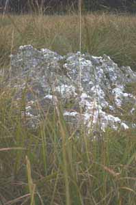
The cairn is buried and mainly hidden under the long grass and almost impossible to photograph although you can feel it under foot. Two crescent of stones remain. On one lies the quartz boulder thought to have possibly been a standing menhir
Comments (0)
|
Add a comment
|
Permalink
Posted by
tuesday
9th October 2006ce