The Modern Antiquarian
Log in
|
Register
Home
Latest Posts
Forums
Maps
Help
Browse Sites
News
Blog
Contributors
The Books
Select
-
Belgium
Denmark
Eire
France
Germany
Greece
Italy
The Netherlands
Norway
Portugal
Republic of Malta
Spain
Sweden
Switzerland
United Kingdom
Wales
Carmarthenshire
Maen Hir
Standing Stone / Menhir
Maen Hir (Standing Stone / Menhir) on The Modern Antiquarian, the UK & Ireland's most popular megalithic community website. 2 images, 1 fieldnote, plus information on many more ancient sites nearby and across the UK & Ireland.
Image © nix stewart
Nearest Town:
Llandovery (10km SSE)
OS Ref (GB):
SN735447 /
Sheets: 146, 147, 160
Latitude:
52° 5' 8.52" N
Longitude:
3° 50' 47.22" W
Added by
tuesday
Images (2)
Fieldnotes (1)
0 discussions
Start a topic
Show |
Hide
Web searches for Maen Hir
Flickr
Google
Google Images
The Megalithic Portal
Bing
Stone Pages
Streetmap.co.uk
Wikipedia
Show map
(inline Google Map)
- Sites within 20 km -
-
Maen Bach (0.58km W) (4 posts)
Crugiau Merched (1.52km W) (22 posts)
Cefn Gwenffrwd (3.2km NE) (3 posts)
Poppy Stone (3.43km NE) (3 posts)
Gelli (3.75km ENE) (9 posts)
Ty Newydd Stone Row (4.19km ENE) (4 posts)
Ty Newydd (4.29km ENE) (7 posts)
Banc Maes-yr-haidd (4.34km WSW) (10 posts)
Cefn Gwenffrwd (4.6km N) (5 posts)
Cefn Gwernffrwd (4.6km N) (2 posts)
Cefn Gwernffrwd (4.6km N) (5 posts)
Cefn Gwernffrwd Complex (4.6km N) (15 posts)
Crug Siarls (5.05km WNW) (10 posts)
Cnwch Eithinog (5.36km NNE) (10 posts)
Cnwch Eithinog (5.42km NNE) (9 posts)
Carn Wen (Cynwyl Gaeo) (5.67km W) (11 posts)
Nant Gwyn (Llanfair-ar-y-Bryn) (6.04km E) (8 posts)
Carreg Garn Fawr (6.09km E) (19 posts)
Carn Wen (6.33km ENE) (2 posts)
Bryn-Poeth-Uchaf North (6.39km E) (17 posts)
Bryn Poeth Uchaf South (6.59km E) (21 posts)
Cerrig Cynant (6.7km E) (24 posts)
Cerrig Cewri (6.86km ENE) (9 posts)
Carn Twrch (7km ENE) (7 posts)
Berrisbrook (7.34km S) (3 posts)
Pen-y-Gurnos (7.81km NNE) (10 posts)
Pen y Corn (7.92km WNW) (10 posts)
Carn Penrhiwllwydog (7.95km N) (8 posts)
Bryn Gwyddel (8.01km NNW) (8 posts)
Carreg Pumsaint (8.28km WSW) (4 posts)
Graig-wen (Llanddewi Brefi) (8.38km WNW) (6 posts)
Dolaucothi Gold Mines (8.41km WSW) (4 posts)
Banc Ty-hen (8.53km W) (9 posts)
Craig Twrch (Cynwyl Gaeo) (8.62km W) (10 posts)
Carn Fawr (Cynwyl Gaeo) (8.63km WNW) (12 posts)
Bryn Mawr (8.67km WNW) (8 posts)
Carn Saith-Wraig (8.98km NNE) (13 posts)
Garn, Banciau Duon (9.3km NW) (10 posts)
Esgair Fraith (Cynwyl Gaeo) (9.34km W) (11 posts)
Carreg y Bwci (9.43km W) (23 posts)
Cefn Pal Hillfort, Cynghordy (9.45km ESE) (10 posts)
Bryn y Gorlan (10.12km N) (25 posts)
Mynydd Pen-y-Fal (Sugar Loaf) (10.13km E) (12 posts)
Cnwch Mawr (Llanddewi Brefi) (10.35km NW) (10 posts)
Crug (10.7km WNW) (12 posts)
Esgair Garn, Llanddewi Abergwesyn (10.84km ENE) (9 posts)
Carreg Samson (10.88km WNW) (1 post)
Hirfaen Gwyddog (11.19km W) (18 posts)
Bryn Goleu (11.32km W) (6 posts)
Bryn Rhudd (11.5km NW) (1 post)
Caer Maurice (11.69km W) (12 posts)
Pen Banc (11.95km W) (0 posts)
Bryn Rhudd (12.06km NW) (22 posts)
Banc-y-Gwyngoed (12.49km NW) (10 posts)
Garn Felen (Llanddewi Brefi) (12.71km NW) (0 posts)
Garn Fawr (Tregaron) (12.74km NNW) (10 posts)
Nant-y-Ffrwd (13.2km N) (4 posts)
Nant Cwm Dwfn (13.33km ENE) (2 posts)
Cwn Bran camp (13.69km S) (1 post)
Nant-y-Maen (13.85km N) (7 posts)
Pen-Y-Ddinas (13.9km SW) (2 posts)
Cefn Cerrig (13.99km N) (14 posts)
Garn Dwad (14.02km ENE) (14 posts)
Blaen Camddwr (14.28km N) (5 posts)
Esgair Gerwyn (14.33km NNE) (4 posts)
Y Fan (14.57km SSW) (1 post)
Cilgwyn (14.63km SSE) (2 posts)
Esgair Perfedd (14.67km N) (7 posts)
Moelau (14.83km N) (8 posts)
Bryn Cosyn (14.84km N) (4 posts)
Esgair Irfon (14.89km NE) (11 posts)
Clawdd Brythonig (14.92km E) (1 post)
Castell Rhyfel (15.16km NNW) (13 posts)
Groes Fawr (15.16km NNW) (6 posts)
Cae'r Maen (15.19km ENE) (9 posts)
Ffynnon-Wen (Llangybi) (15.26km W) (1 post)
Careg Fawr (15.77km S) (5 posts)
Pen y Garn-goch (15.94km ENE) (11 posts)
Y Garn (Garn Gron) (15.96km NNW) (11 posts)
Banc Paderau (16.03km ENE) (8 posts)
Castell Tregaron. Sunnyhill wood camp (16.19km NW) (13 posts)
Garn Wen (16.23km E) (1 post)
Garn Gron (16.35km N) (17 posts)
Tomen-y-Rhos (16.55km SE) (12 posts)
Y Pigwn Cairns (16.61km ESE) (14 posts)
Y Pigwn (16.81km ESE) (42 posts)
Pen Caenewydd, Mynydd Myddfai (16.89km SE) (17 posts)
Pant Meddygon (17.66km SE) (18 posts)
Carn Fflur (17.67km N) (24 posts)
Pen Twr Ring Cairn, Cefn Gardys (17.68km ENE) (8 posts)
Drum Nant y Gorlan (17.87km NE) (1 post)
Blaen Clydach Fach (18.02km ESE) (1 post)
Cwm Henwen Cairn (18.03km ESE) (12 posts)
Cwm Henwen (18.05km ESE) (13 posts)
Bryngwyn Bach (18.11km NNW) (20 posts)
Pant Madog (18.37km ESE) (11 posts)
Crug-y-Bwdran (18.53km WSW) (7 posts)
Drygarn Fawr (18.64km NE) (22 posts)
Bryn-y-Crofftau (18.74km N) (12 posts)
Carn Blaen Glasffrwd (18.77km N) (16 posts)
Garn Wen, Llanfihangel Abergwesyn (18.8km ENE) (10 posts)
Gwern Wyddog (19.04km ESE) (11 posts)
Pen-y-Bwlch (West) (19.5km N) (13 posts)
Pen-y-Bwlch (Ystrad Fflur) (19.54km N) (8 posts)
Ynys Hir (19.61km E) (15 posts)
Tri Chrugiau, Mynydd Epynt (19.67km E) (10 posts)
Carreg Wen Fawr (Llanwrthwl) (19.71km NNE) (1 post)
Varlen Cairn, Traianmawr (19.92km ESE) (1 post)
- Facilities within 20 km -
-
Llandovery Tourist Inf... (Tourist Information: 10.9 km SSE)
Llanwrtyd Wells Touris... (Tourist Information: 14.4 km ENE)
- Add -
-
Add news
Add an image
Add fieldnotes
Add folklore
Add miscellaneous
Add a link
-
Add a site
Add a nearby facility
Add an alternative name/spelling
Images
(click to view fullsize)
Add an image
Fieldnotes
Add fieldnotes
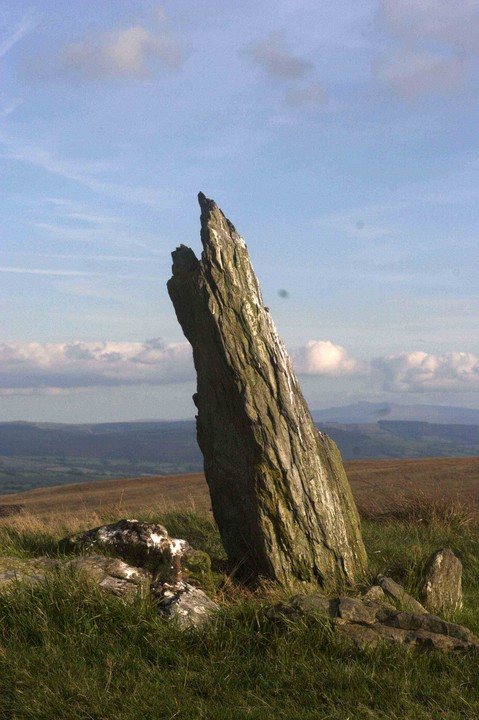
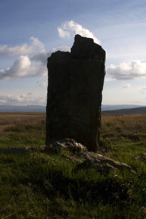
Another isolated, splintered slate slab surmounting a small cairn of packing stones on the mountain. It is intervisible with Maen Bach and the Crugiau Merched cairns and is the most prominent of this ritual complex.
DIMENSIONS
1.4m(h), 0.3m(w),0.4mm(d)
Comments (0)
|
Add a comment
|
Permalink
Posted by
tuesday
9th October 2006ce
Edited 9th October 2006ce