The Modern Antiquarian
Log in
|
Register
Home
Latest Posts
Forums
Maps
Help
Browse Sites
News
Blog
Contributors
The Books
Select
-
Belgium
Denmark
Eire
France
Germany
Greece
Italy
The Netherlands
Norway
Portugal
Republic of Malta
Spain
Sweden
Switzerland
United Kingdom
Wales
Flintshire, Denbighshire and Wrexham
Rhyd-y-Gethin
Standing Stone / Menhir
Rhyd-y-Gethin (Standing Stone / Menhir) on The Modern Antiquarian, the UK & Ireland's most popular megalithic community website. 2 images, 1 fieldnote, plus information on many more ancient sites nearby and across the UK & Ireland.
Image © Idwal
Nearest Town:
Bala (12km W)
OS Ref (GB):
SJ033332 /
Sheet: 125
Latitude:
52° 53' 13.74" N
Longitude:
3° 26' 14.44" W
Added by
Idwal
Images (2)
Fieldnotes (1)
0 discussions
Start a topic
Show |
Hide
Web searches for Rhyd-y-Gethin
Flickr
Google
Google Images
The Megalithic Portal
Bing
Stone Pages
Streetmap.co.uk
Wikipedia
Show map
(inline Google Map)
- Sites within 20 km -
-
Yr Aran (0.28km ESE) (9 posts)
Yr Aran cairns (0.48km SSW) (31 posts)
Rhyd-y-Gethin (Cairns) (0.56km S) (20 posts)
Cefn Penagored (0.72km NE) (14 posts)
Cefn Penagored Ridge (0.85km ENE) (17 posts)
Penagored (1.11km N) (6 posts)
Nant Esgeiriau (1.14km E) (33 posts)
Cwm Tywyll (1.31km ENE) (28 posts)
Cwm Tywyll (1.43km ENE) (3 posts)
Pennant cairn (1.52km ENE) (23 posts)
Ffridd Camen, Y Berwyn (1.92km NE) (9 posts)
Graig Yr Arian (Silver rock) (3.35km WNW) (6 posts)
Moel Sych (3.58km E) (16 posts)
Cwm Rhiwiau (3.74km ESE) (0 posts)
Carnedd Wen (3.85km W) (8 posts)
Cerrig Beddau (3.9km ESE) (1 post)
Rhos y Beddau (3.9km ESE) (4 posts)
Rhos y Beddau (3.9km ESE) (12 posts)
Cerrig Bwlch y fedw (3.9km NE) (12 posts)
Cader Berwyn cairn II (3.93km E) (21 posts)
Cader Berwyn (3.94km E) (10 posts)
Moel Pearce (3.94km NE) (4 posts)
Trawsnant (3.95km ENE) (7 posts)
Foel Cwm-Sian Llwyd (4.1km WSW) (14 posts)
Moel ty Uchaf (4.61km NNE) (95 posts)
Bwlch Maen Gwynedd (4.65km ENE) (9 posts)
Bwrdd Arthur (4.66km ENE) (26 posts)
Branas Uchaf (4.82km NW) (27 posts)
Afon Disgynfa (5.08km ESE) (16 posts)
Craig ty-glas (5.61km SSE) (20 posts)
Tyfos (5.62km NNW) (19 posts)
Bedd Crynddyn (5.76km SE) (16 posts)
Craig Rhiwarth Cairn I (6.42km SE) (1 post)
Garnedd Wen (6.47km ESE) (5 posts)
Tan-y-Coed (6.54km N) (20 posts)
Craig Rhiwarth Cairn II (6.6km SE) (7 posts)
Craig Rhiwarth (6.63km SE) (40 posts)
Glan Hafon cairn (6.65km ESE) (19 posts)
Mynydd Tarw, Y Berwyn (7.97km E) (12 posts)
Cefn Ddwysarn Camp (8.26km WNW) (2 posts)
Craig yr Arian (8.69km S) (1 post)
Caer Eini (8.7km NW) (13 posts)
Nant Croes-Y-Wernen (8.74km NE) (8 posts)
Cefn Caer Euni Circles (8.75km NW) (20 posts)
Gwerclas (9.13km N) (3 posts)
Gwernclas Mound (9.16km N) (1 post)
Carnedd Das Eithin (9.52km SSE) (0 posts)
Coed-y-Bedo Standing Stone (9.53km WNW) (7 posts)
Siglem Las (9.72km S) (0 posts)
Cwm Main (9.76km WNW) (1 post)
Pen-Plaenau (9.82km ENE) (9 posts)
Carnedd Gerrig (10.15km S) (8 posts)
Afon y Dolau Gwynion (10.28km S) (14 posts)
Tyn-y-Cefn Cursus (10.47km NNE) (1 post)
Moel Fferna (10.63km NE) (15 posts)
Corwen Cross (11.04km NNE) (9 posts)
Foel y Geifr (11.11km WSW) (5 posts)
Carreg y Big yn y Fach Rhewllyd (11.13km NNE) (5 posts)
Llanrhaeadr-ym-Mochnant (11.65km ESE) (4 posts)
Cerrig Gwynion (11.88km ENE) (17 posts)
Caer Drewyn (12.41km NNE) (24 posts)
Carreg-y-tair Eglwys (12.49km S) (1 post)
Carnedd Rhys Goch (12.76km ENE) (4 posts)
Garnedd Fawr (Foel Goch) (13.14km WNW) (11 posts)
Maes Mochnant (13.33km ESE) (15 posts)
Owain Glyndwr's Mount (13.65km NE) (14 posts)
Moel y Gadfa (13.69km SW) (8 posts)
Tomen y Meirw (13.76km ENE) (5 posts)
Moel y Garnedd, Gwastadros (13.82km W) (8 posts)
Tomen y Gwyddel (14.34km ENE) (7 posts)
Caer Caradog (16.06km NW) (20 posts)
Dinas Melin y Wig (16.06km N) (7 posts)
Llwyn Bryn Dinas (16.33km E) (11 posts)
Cronglwyd Fawr (16.58km NW) (1 post)
Carneddau'r Gwragedd (17.7km SW) (1 post)
Garw Fynydd (17.9km N) (2 posts)
Cerrig-yr-Helfa (18.08km SSW) (2 posts)
Garnedd Wen (18.33km W) (15 posts)
Moel y Gaer (18.7km NE) (14 posts)
Maen Llwyd (Cloceinog) (19.13km N) (5 posts)
Pant y Maen (19.18km NE) (6 posts)
Moel y Gamelin (19.48km NE) (10 posts)
Llwynmawr (19.48km ENE) (6 posts)
Ty Mawr Rhos Ganol (19.68km NE) (1 post)
Carnedd-y-Filiast (19.73km W) (3 posts)
Mynydd-y-Bryn (19.74km E) (0 posts)
Afon Ceirw (Destroyed) (19.99km WNW) (3 posts)
Bryn Beddau (19.99km N) (18 posts)
- Facilities within 20 km -
-
Lake Vyrnwy Tourist In... (Tourist Information: 13.7 km S)
- Add -
-
Add news
Add an image
Add fieldnotes
Add folklore
Add miscellaneous
Add a link
Add a nearby facility
Add an alternative name/spelling
Images
(click to view fullsize)
Add an image
Fieldnotes
Add fieldnotes
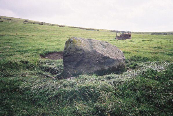
This stone looks like a beached whale. It is clearly visible in the middle of the field on gently sloping ground in a slight hollow. GPS reading SJ 0332 3329. 1m high, 1.5m wide, 0.65m deep with long axis 80-260 degrees
Comments (0)
|
Add a comment
|
Permalink
Posted by
Idwal
2nd October 2006ce

 Posted by Idwal