The Modern Antiquarian
Log in
|
Register
Home
Latest Posts
Forums
Maps
Help
Browse Sites
News
Blog
Contributors
The Books
Select
-
Belgium
Denmark
Eire
France
Germany
Greece
Italy
The Netherlands
Norway
Portugal
Republic of Malta
Spain
Sweden
Switzerland
United Kingdom
Scotland
Dumfries and Galloway
Blairbuy Farm
Blairbuy 4
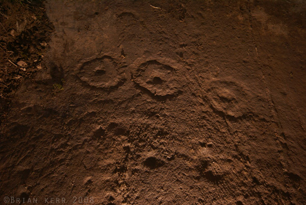
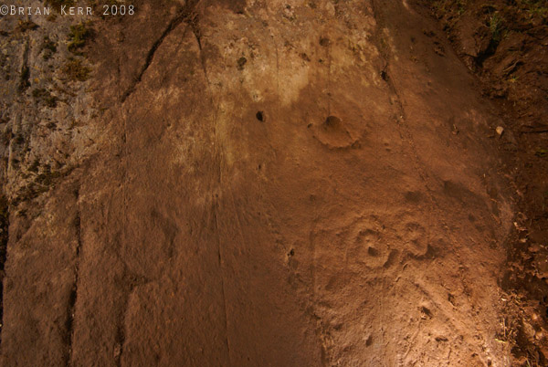
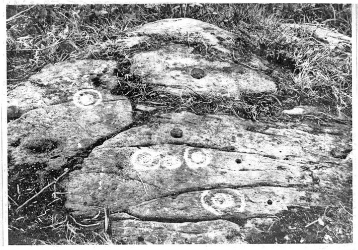
Cup and Ring Marks / Rock Art
Blairbuy 4 (Cup and Ring Marks / Rock Art) on The Modern Antiquarian, the UK & Ireland's most popular megalithic community website. 4 images, 1 weblink, plus information on many more ancient sites nearby and across the UK & Ireland.
Image © unknown
Nearest Town:
Whithorn (7km E)
OS Ref (GB):
NX368420 /
Sheet: 83
Latitude:
54° 44' 46.3" N
Longitude:
4° 32' 8.87" W
Added by
rockartwolf
Images (4)
Links (1)
0 discussions
Start a topic
Show |
Hide
Web searches for Blairbuy 4
Flickr
Google
Google Images
MAGIC
The Megalithic Portal
Bing
Stone Pages
Streetmap.co.uk
Wikipedia
Show map
(inline Google Map)
- Sites within 20 km -
-
Blairbuy 6 (0.41km NW) (9 posts)
Blairbuy Farm (0.54km WSW) (1 post)
Fell of Barhullion (0.7km WSW) (6 posts)
The Wren's Egg & Nest (0.7km WSW) (45 posts)
Blairbuy - 10 (0.71km ESE) (3 posts)
Blairbuy Standing Stones (0.72km SW) (10 posts)
Blairbuy 1 (0.72km ESE) (8 posts)
Blairbuy 3 (0.76km ENE) (6 posts)
Blairbuy 5 (0.82km E) (4 posts)
Blairbuy 2 (0.94km ESE) (5 posts)
White Loch of Myrton (1.6km WNW) (8 posts)
Knock (1.92km S) (41 posts)
St Medana's Well (1.97km S) (5 posts)
Barsalloch Point (2.22km WSW) (9 posts)
Drumtroddan Standing Stones (2.32km NNW) (37 posts)
Big Balcraig (2.47km NNE) (7 posts)
Drumtroddan Carved Rocks (2.74km NNW) (48 posts)
Glasserton Mains (5.94km ESE) (19 posts)
Culgarie (6.25km N) (12 posts)
Rispain Camp (6.43km E) (7 posts)
Culnoag (6.91km NE) (7 posts)
Elrig (7.44km WNW) (8 posts)
Whithorn (7.78km E) (2 posts)
Gallows Outon 1 (7.97km ENE) (4 posts)
Gallows Outon 2 (8.17km ENE) (4 posts)
Airyolland E (8.35km WNW) (10 posts)
Airyolland W (8.35km WNW) (10 posts)
Loch Head (8.36km WNW) (5 posts)
Claunch (8.54km NE) (15 posts)
Carlin Stone (8.78km WNW) (8 posts)
House of Elrig (9.48km WNW) (0 posts)
Broughton Mains (9.66km ENE) (21 posts)
Little Balsmith (10.1km E) (5 posts)
Mochrum Fell (Elrig) (10.24km WNW) (18 posts)
Corwall S (10.66km WNW) (10 posts)
Corwall E (10.67km WNW) (9 posts)
High Moor Hut Circle (11km WNW) (9 posts)
Brae Moor (11.05km WNW) (7 posts)
Brae Farm SW (11.07km WNW) (9 posts)
Brae Farm NE (11.11km WNW) (7 posts)
Brae Farm Central (11.13km WNW) (7 posts)
North Balfern (11.13km NE) (6 posts)
Chapel Finian (11.3km W) (8 posts)
North Balfern HillFort (11.31km NE) (2 posts)
Lang Riggs (The May) (11.41km WNW) (7 posts)
Court Cairn, The May (11.46km WNW) (6 posts)
The May (11.53km WNW) (6 posts)
Boyach (11.68km E) (3 posts)
Burrow Head (11.7km ESE) (1 post)
Culscadden (12.14km ENE) (8 posts)
Steinhead Mote (12.63km E) (4 posts)
Isle Head (12.66km E) (0 posts)
Penkiln (12.67km ENE) (32 posts)
Cairn Buy (13.36km WNW) (7 posts)
Bladnoch (13.45km NNE) (10 posts)
Hole Stone (13.68km NNW) (13 posts)
Green House Bridge (13.69km WNW) (6 posts)
White Cairn, Crouse (13.76km NNW) (6 posts)
Redbrae (13.98km N) (3 posts)
Cunningham (14.17km N) (5 posts)
Craignarget Hill (14.19km WNW) (11 posts)
Torhousekie (14.45km N) (81 posts)
Torhousekie Stone Row (14.45km N) (22 posts)
Torhousekie (14.78km N) (8 posts)
Torhousekie Farm (14.78km N) (10 posts)
Castle Loch (14.95km WNW) (16 posts)
High Gillespie (15.34km WNW) (11 posts)
Boreland (16.01km NNW) (4 posts)
Boreland (16.15km NNW) (4 posts)
White Cairn, Boreland (16.25km NNW) (7 posts)
Cairnhouse W (16.55km N) (7 posts)
Culroy Farm Cairn (16.55km WNW) (4 posts)
White Cairn, Culroy (16.85km WNW) (5 posts)
Cairnhouse E (16.85km NNE) (5 posts)
Mull of Sinniness (17.05km W) (4 posts)
Machermore (17.28km WNW) (14 posts)
Culquhasen (17.42km WNW) (10 posts)
Culquhasen (17.42km WNW) (0 posts)
Knock Fell (17.78km WNW) (3 posts)
Doon of Carsluith (17.94km NE) (8 posts)
Laigh Sinniness (18.27km W) (5 posts)
Kirkmabreck (18.29km NE) (14 posts)
Whitefield Loch (18.4km WNW) (6 posts)
Kirkdale House (18.49km NE) (2 posts)
Barholm 1 (18.49km NE) (1 post)
Kirkdale Mains Stone (18.56km NE) (1 post)
Kirkmuir (18.69km NE) (3 posts)
Barholm 2 (18.79km NE) (1 post)
Tree Island, Whitefield Loch (18.8km WNW) (1 post)
Kirkmuir 1a & 1b (18.84km NE) (1 post)
Kirkmuir 2 (18.84km NE) (1 post)
Kirkmuir 4 (18.9km NE) (1 post)
Barnsallie Fell (18.9km WNW) (8 posts)
Kirkmuir 3 (18.91km NE) (1 post)
Cairnholy (19.09km NE) (138 posts)
Cairnholy 01 & 02 (19.09km NE) (8 posts)
Bagbie Stone (19.2km NE) (8 posts)
Kirkclaugh (19.27km ENE) (1 post)
Bagbie Wall Stone (19.31km NE) (7 posts)
Cairnholy 09 (19.32km NE) (5 posts)
Bagbie Cairn (19.35km NE) (15 posts)
Bagbie Four Poster (19.35km NE) (10 posts)
Cairnholy Cairn (19.38km NE) (5 posts)
Cairnholy 04 (19.38km NE) (1 post)
Stair Haven (19.44km W) (18 posts)
Cairnholy 08 (19.45km NE) (1 post)
Cairnholy 03 (19.5km NE) (0 posts)
Bardristane 1 (19.51km NE) (5 posts)
Cairnholy 05 (19.51km NE) (2 posts)
Cairn Hill (Barraer) (19.52km N) (9 posts)
Cairnholy 07 (19.58km NE) (0 posts)
Bardristane 4 (19.73km NE) (6 posts)
Blackmyre Farm (19.73km NE) (2 posts)
Kirkclaugh (19.78km ENE) (2 posts)
Bardristane 3 (19.81km NE) (3 posts)
Barholm 3 (19.84km NE) (2 posts)
Cairnholy 06 (19.87km NE) (1 post)
Blackmyre Moor (19.9km NE) (5 posts)
Mossyard (19.98km ENE) (21 posts)
- Facilities within 20 km -
-
Cairnholy Old Farmhouse (Bed & Breakfast: 19.2 km NE)
- Add -
-
Add news
Add an image
Add fieldnotes
Add folklore
Add miscellaneous
Add a link
-
Add a site
Add a nearby facility
Add an alternative name/spelling
Images
(click to view fullsize)
Add an image
Links
Add a link
Blairbuy 4 on BRAC Updated
Blairbuy 4 on BRAC
Comments (0)
|
Add a comment
|
Permalink
Posted by
markj99
9th January 2021ce