The Modern Antiquarian
Log in
|
Register
Home
Latest Posts
Forums
Maps
Help
Browse Sites
News
Blog
Contributors
The Books
Select
-
Belgium
Denmark
Eire
France
Germany
Greece
Italy
The Netherlands
Norway
Portugal
Republic of Malta
Spain
Sweden
Switzerland
United Kingdom
County Meath
Boyne Valley Complex
Newgrange
Newgrange Tumulus A
Passage Grave
Newgrange Tumulus A (Passage Grave) on The Modern Antiquarian, the UK & Ireland's most popular megalithic community website. 2 images, 1 fieldnote, plus information on many more ancient sites nearby and across the UK & Ireland.
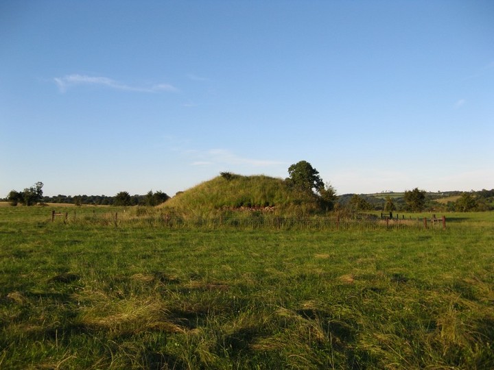
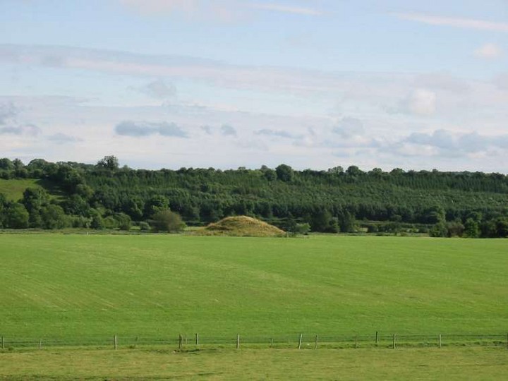
Image © Bawn79 © 2007
Nearest Town:
Slane (5km W)
OS Ref (IE):
O012724 /
Sheet: 43
Latitude:
53° 41' 29.32" N
Longitude:
6° 28' 4.25" W
Added by
ryaner
Images (2)
Fieldnotes (1)
0 discussions
Start a topic
Show |
Hide
Web searches for Newgrange Tumulus A
Flickr
Google
Google Images
The Megalithic Portal
Bing
Stone Pages
Wikipedia
Show map
(inline Google Map)
- Sites within 20 km -
-
Hedgerow Stone (0.41km ENE) (2 posts)
Newgrange Cursus (0.42km WNW) (2 posts)
Newgrange Tumulus B (0.45km E) (3 posts)
Newgrange (0.61km WNW) (128 posts)
The Great Circle (0.67km W) (23 posts)
Newgrange Standing Stone C (0.67km W) (6 posts)
Newgrange K & L (0.76km W) (10 posts)
Dowth Mound II (1.2km NE) (0 posts)
Dowth Mound III (1.34km NE) (0 posts)
Dowth I (1.78km NE) (68 posts)
Dowth (1.78km NE) (4 posts)
Knowth (1.87km W) (120 posts)
Dowth II (2.34km NE) (1 post)
Dowth Mound I (2.4km NE) (0 posts)
Dowth Henge (2.83km NE) (10 posts)
Monknewtown Pond (3km NW) (4 posts)
Longford (3.05km ESE) (0 posts)
Cloghalea (3.11km NE) (6 posts)
Monknewtown II (3.12km NNW) (3 posts)
Rossnaree (3.13km WSW) (3 posts)
Monknewtown (3.15km NNW) (2 posts)
Littlegrange (3.47km NNE) (9 posts)
Townley Hall Souterrain (4.2km NNE) (0 posts)
Townley Hall Barrow (4.62km NE) (0 posts)
Gallows Hill (4.74km W) (0 posts)
Stanley Hill (4.82km W) (0 posts)
Johnstown (5km WSW) (0 posts)
Oldbridge (5.12km NE) (7 posts)
Hill of Slane Souterrain (5.27km W) (0 posts)
Mellifont (5.59km N) (0 posts)
Hill of Slane Barrow (5.84km W) (1 post)
Painestown (6.27km WSW) (0 posts)
Gaulstown (7.05km SSE) (3 posts)
Rathmaiden (7.05km WNW) (0 posts)
Bellewstown (7.23km ESE) (5 posts)
Boolies Great (8.28km SE) (0 posts)
Hilltown Little (8.38km ESE) (0 posts)
Gernonstown (8.41km W) (2 posts)
Danestown Ringfort (8.44km SSW) (4 posts)
Bey More (8.59km ENE) (0 posts)
Drogheda (8.68km ENE) (0 posts)
Gernonstown (9.07km W) (5 posts)
Kingstown & Carnuff Great (9.31km WSW) (1 post)
Realtoge (9.31km SW) (4 posts)
Davidstown Barrow (9.42km W) (0 posts)
Kilbride (Talbotstown Lower By.) (9.6km N) (6 posts)
Gerrardstown (10.15km SW) (0 posts)
Mullagharoy (10.2km WNW) (4 posts)
The Stuck Stone (10.59km WNW) (0 posts)
Fieldstown (10.71km NE) (7 posts)
Balgeeth (10.8km SE) (2 posts)
Stackallan (11.07km W) (2 posts)
Slieve Beagh (11.28km WNW) (13 posts)
Mount Oriel (11.28km NW) (3 posts)
Paddock (11.33km NNE) (15 posts)
Dunmore (11.44km NW) (0 posts)
Moorepark (11.92km SE) (0 posts)
Mullagha (11.92km W) (6 posts)
Mullahteelin (12.19km E) (0 posts)
Roadmain (12.26km SSE) (0 posts)
Clonardran (12.35km SW) (0 posts)
Piperstown (12.45km NE) (1 post)
Belpatrick (12.5km NW) (0 posts)
Heathtown Henge I (12.66km ESE) (0 posts)
Piercetown (12.76km SSE) (0 posts)
Greenanstown (12.83km ESE) (4 posts)
Mullaghash (12.86km NW) (2 posts)
Mullaghash (12.86km NW) (3 posts)
Heathtown Henge II (12.98km ESE) (5 posts)
Heathtown Mound (13.05km ESE) (4 posts)
Garlagh (13.09km SW) (0 posts)
Drumshallon (13.18km NE) (0 posts)
Rath Lugh (13.25km SW) (4 posts)
Lismullin (13.31km SW) (8 posts)
Rathbran More (13.31km WNW) (6 posts)
Herbertstown (13.51km ESE) (4 posts)
Milltown (13.55km NE) (0 posts)
Micknanstown (13.61km ESE) (2 posts)
Blundelstown (13.81km SW) (0 posts)
White Mountain (13.97km NW) (0 posts)
Corracon (14.05km NW) (0 posts)
Collierstown (14.06km SSW) (0 posts)
Fourknocks (14.11km ESE) (35 posts)
Primatestown (14.26km SSE) (0 posts)
Laytown (An Inse) (14.29km E) (6 posts)
Fourknocks (14.32km ESE) (5 posts)
Rathkenny (14.34km W) (8 posts)
Termonfeckin (14.54km ENE) (0 posts)
Windmill Hill (14.61km SSE) (0 posts)
Baltray (14.64km ENE) (12 posts)
Kilbrew (14.9km SSE) (3 posts)
Cabragh (14.94km SW) (0 posts)
Hodgetown (15.28km ESE) (0 posts)
Newtown (15.4km SSE) (0 posts)
The Banqueting Hall (15.4km SW) (10 posts)
Garristown (15.42km SE) (0 posts)
The Sloping Trenches (15.44km SW) (3 posts)
Grainne's Enclosure (15.44km SW) (6 posts)
Ardsallagh (15.51km WSW) (2 posts)
Churchyard Stones (15.58km SW) (12 posts)
Rath of Synods (15.7km SW) (7 posts)
The Barrows (15.7km SW) (0 posts)
Cormac's House (15.78km SW) (9 posts)
The Mound of Hostages (15.78km SW) (28 posts)
Lia Fail (15.78km SW) (23 posts)
The King's Seat (15.78km SW) (12 posts)
The Royal Enclosure (15.78km SW) (2 posts)
Rath Laoghaire (15.86km SW) (2 posts)
Knockdinnin (15.93km N) (0 posts)
Tullog (15.95km ESE) (0 posts)
Knock (16.1km W) (2 posts)
Purcellstown (16.18km NW) (0 posts)
Blakestown (16.22km NW) (0 posts)
Roestown (16.28km NNW) (0 posts)
Dardisrath (16.36km ENE) (0 posts)
Westown North (16.38km ESE) (1 post)
Hurlstone (16.57km NW) (6 posts)
Rath Maeve (16.63km SW) (10 posts)
Walshestown (16.7km NE) (0 posts)
South Stone (16.8km NNW) (2 posts)
Barnaveddoge Mound (16.9km NNW) (0 posts)
North Stone (16.98km NNW) (0 posts)
Trevet (17.31km SSW) (3 posts)
Mullameelan (17.4km NW) (0 posts)
Arch Hall (17.43km W) (6 posts)
Gormanston (17.65km E) (6 posts)
Gormanston Beach (17.99km E) (3 posts)
Skeaghmore (18.17km NNE) (0 posts)
Labanstown (18.55km NE) (0 posts)
Damastown (18.57km ESE) (3 posts)
Mallahow (18.59km ESE) (0 posts)
Kichenstown (18.93km ESE) (0 posts)
Knockbrack (19.07km ESE) (0 posts)
Knockbrack (19.19km ESE) (1 post)
Bremore (19.41km E) (36 posts)
Dunsany (19.69km SSW) (4 posts)
Cooljohn (19.76km SW) (2 posts)
Clogher Head (19.9km ENE) (1 post)
- Add -
-
Add news
Add an image
Add fieldnotes
Add folklore
Add miscellaneous
Add a link
-
Add a site
Add a nearby facility
Add an alternative name/spelling
Images
(click to view fullsize)
Add an image
Fieldnotes
Add fieldnotes
Although I didn't get to visit this Passage Grave up close (in a field full of crop and not part of the Newgrange 'tour') I was able to see it out of the bus window.
Easily seen on the left (when travelling from the visitors centre to Newgrange)
Comments (0)
|
Add a comment
|
Permalink
Posted by
CARL
7th June 2011ce