The Modern Antiquarian
Log in
|
Register
Home
Latest Posts
Forums
Maps
Help
Browse Sites
News
Blog
Contributors
The Books
Select
-
Belgium
Denmark
Eire
France
Germany
Greece
Italy
The Netherlands
Norway
Portugal
Republic of Malta
Spain
Sweden
Switzerland
United Kingdom
County Meath
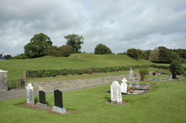
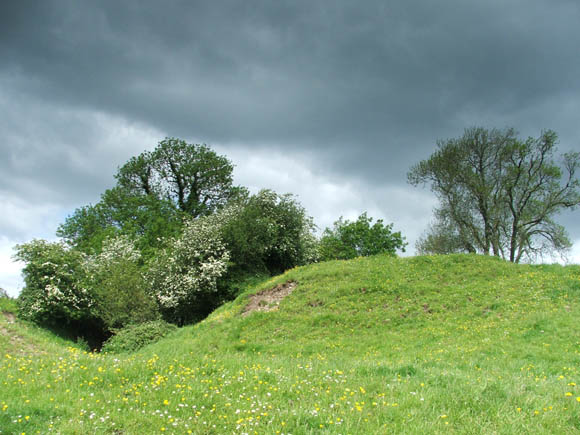
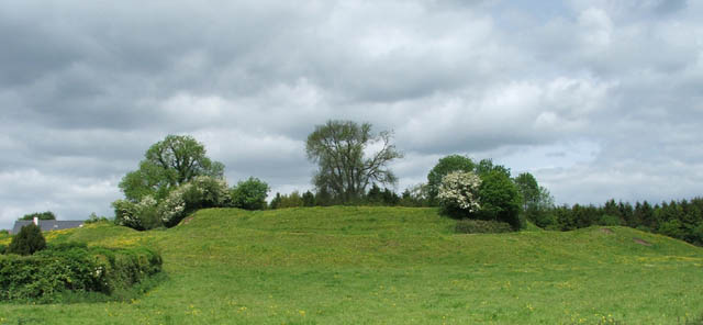
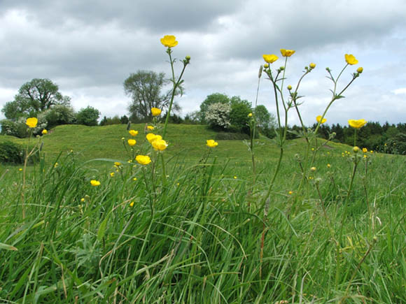
Danestown Ringfort
Rath
Danestown Ringfort (Rath) on The Modern Antiquarian, the UK & Ireland's most popular megalithic community website. 4 images, plus information on many more ancient sites nearby and across the UK & Ireland.
Image © megaman
Nearest Town:
Carnew (4km E)
OS Ref (IE):
N977647 /
Sheet: 43
Latitude:
53° 37' 22.72" N
Longitude:
6° 31' 23.65" W
Added by
megaman
Images (4)
0 discussions
Start a topic
Show |
Hide
Web searches for Danestown Ringfort
Flickr
Google
Google Images
The Megalithic Portal
Bing
Stone Pages
Wikipedia
Show map
(inline Google Map)
- Sites within 20 km -
-
Gerrardstown (3.61km W) (0 posts)
Realtoge (4.37km W) (4 posts)
Gaulstown (4.44km ENE) (3 posts)
Clonardran (5.08km WSW) (0 posts)
Rath Lugh (5.08km SW) (4 posts)
Lismullin (5.26km SW) (8 posts)
Garlagh (5.48km WSW) (0 posts)
Collierstown (5.62km SSW) (0 posts)
Blundelstown (5.89km WSW) (0 posts)
Painestown (5.99km NW) (0 posts)
Boolies Great (6.57km E) (0 posts)
Kingstown & Carnuff Great (6.73km WNW) (1 post)
Cabragh (6.77km SW) (0 posts)
Rossnaree (7.2km N) (3 posts)
Johnstown (7.34km NNW) (0 posts)
The Banqueting Hall (7.37km SW) (10 posts)
Roadmain (7.44km ESE) (0 posts)
Grainne's Enclosure (7.46km SW) (6 posts)
The Sloping Trenches (7.46km SW) (3 posts)
Churchyard Stones (7.48km SW) (12 posts)
Longford (7.54km NE) (0 posts)
Rath of Synods (7.63km SW) (7 posts)
The Barrows (7.63km SW) (0 posts)
Cormac's House (7.7km SW) (9 posts)
The Mound of Hostages (7.7km SW) (28 posts)
Lia Fail (7.7km SW) (23 posts)
The Royal Enclosure (7.7km SW) (2 posts)
The King's Seat (7.7km SW) (12 posts)
Rath Laoghaire (7.77km SW) (2 posts)
Piercetown (8.08km ESE) (0 posts)
Windmill Hill (8.22km ESE) (0 posts)
Balgeeth (8.34km E) (2 posts)
Rath Maeve (8.35km SW) (10 posts)
Kilbrew (8.37km SE) (3 posts)
Newgrange Tumulus B (8.43km NNE) (3 posts)
Newgrange Tumulus A (8.44km NNE) (3 posts)
Newgrange K & L (8.46km NNE) (10 posts)
The Great Circle (8.49km NNE) (23 posts)
Newgrange Standing Stone C (8.49km NNE) (6 posts)
Newgrange (8.56km NNE) (128 posts)
Moorepark (8.57km E) (0 posts)
Newgrange Cursus (8.6km NNE) (2 posts)
Primatestown (8.61km ESE) (0 posts)
Hedgerow Stone (8.7km NNE) (2 posts)
Knowth (8.93km N) (120 posts)
Trevet (9.12km S) (3 posts)
Gallows Hill (9.53km NNW) (0 posts)
Bellewstown (9.58km ENE) (5 posts)
Ardsallagh (9.59km WSW) (2 posts)
Dowth Mound II (9.59km NNE) (0 posts)
Dowth Mound III (9.68km NNE) (0 posts)
Stanley Hill (9.73km NNW) (0 posts)
Newtown (10.16km ESE) (0 posts)
Dowth I (10.17km NNE) (68 posts)
Dowth (10.18km NNE) (4 posts)
Hill of Slane Souterrain (10.34km NNW) (0 posts)
Hilltown Little (10.36km ENE) (0 posts)
Hill of Slane Barrow (10.52km NNW) (1 post)
Dowth II (10.59km NE) (1 post)
Dowth Mound I (10.68km NE) (0 posts)
Monknewtown Pond (10.92km NNE) (4 posts)
Dowth Henge (11.05km NE) (10 posts)
Monknewtown (11.16km NNE) (2 posts)
Monknewtown II (11.22km NNE) (3 posts)
Dunsany (11.29km SW) (4 posts)
Gernonstown (11.31km NW) (2 posts)
Cloghalea (11.36km NE) (6 posts)
Garristown (11.56km ESE) (0 posts)
Gernonstown (11.83km NW) (5 posts)
Littlegrange (11.9km NNE) (9 posts)
Heathtown Henge I (11.91km E) (0 posts)
Stackallan (11.92km WNW) (2 posts)
Cooljohn (12.43km WSW) (2 posts)
Townley Hall Souterrain (12.64km NNE) (0 posts)
Heathtown Henge II (12.65km E) (5 posts)
Heathtown Mound (12.66km E) (4 posts)
Rathmaiden (12.68km NNW) (0 posts)
Townley Hall Barrow (13.03km NNE) (0 posts)
Micknanstown (13.04km E) (2 posts)
Mullagha (13.05km WNW) (6 posts)
Oldbridge (13.17km NE) (7 posts)
Davidstown Barrow (13.24km NW) (0 posts)
Mooretown (13.4km SSW) (0 posts)
Fourknocks (13.4km E) (35 posts)
Knockmark (13.45km SSW) (0 posts)
Greenanstown (13.45km E) (4 posts)
Fourknocks (13.69km E) (5 posts)
Mellifont (13.73km NNE) (0 posts)
Herbertstown (13.79km E) (4 posts)
Mullahteelin (14.13km ENE) (0 posts)
Bey More (14.62km ENE) (0 posts)
Westown North (15.13km E) (1 post)
Culmullin (15.28km SSW) (4 posts)
Hodgetown (15.3km E) (0 posts)
Drogheda (15.5km NE) (0 posts)
Mullagharoy (15.86km NNW) (4 posts)
Mallahow (16.31km E) (0 posts)
Derrypatrick (16.33km SW) (3 posts)
Tullog (16.35km E) (0 posts)
The Stuck Stone (16.35km NNW) (0 posts)
Damastown (16.36km E) (3 posts)
Slieve Beagh (16.37km NW) (13 posts)
Arch Hall (17.17km WNW) (6 posts)
Rathkenny (17.4km NW) (8 posts)
Kilbride (Talbotstown Lower By.) (17.92km NNE) (6 posts)
Iskaroon (18.01km WSW) (5 posts)
Newtown (Navan Upper By.) (18.1km WSW) (3 posts)
Lismahon (18.12km S) (1 post)
Dunmore (18.2km NNW) (0 posts)
Kichenstown (18.3km E) (0 posts)
Knockbrack (18.34km E) (1 post)
Knockbrack (18.42km E) (0 posts)
Mount Oriel (18.58km N) (3 posts)
Knock (18.71km WNW) (2 posts)
Hollywood Great (18.89km E) (1 post)
Nags Head (18.89km E) (0 posts)
Laytown (An Inse) (18.91km ENE) (6 posts)
Rathbran More (19.03km NNW) (6 posts)
Teltown (19.08km W) (1 post)
Fieldstown (19.08km NE) (7 posts)
Belpatrick (19.14km NNW) (0 posts)
Paddock (19.76km NNE) (15 posts)
- Add -
-
Add news
Add an image
Add fieldnotes
Add folklore
Add miscellaneous
Add a link
-
Add a site
Add a nearby facility
Add an alternative name/spelling
Images
(click to view fullsize)
Add an image
 Image © megaman