The Modern Antiquarian
Log in
|
Register
Home
Latest Posts
Forums
Maps
Help
Browse Sites
News
Blog
Contributors
The Books
Select
-
Belgium
Denmark
Eire
France
Germany
Greece
Italy
The Netherlands
Norway
Portugal
Republic of Malta
Spain
Sweden
Switzerland
United Kingdom
County Kildare
Old Kilcullen
Christianised Site
Old Kilcullen (Christianised Site) on The Modern Antiquarian, the UK & Ireland's most popular megalithic community website. 1 image, plus information on many more ancient sites nearby and across the UK & Ireland.
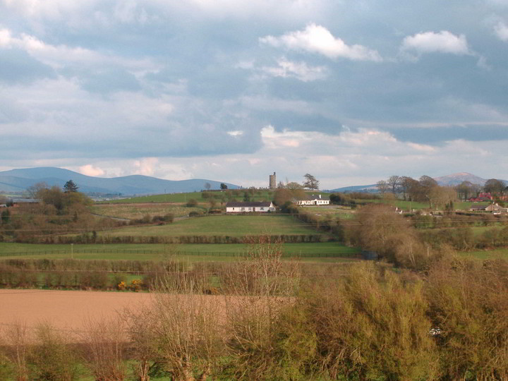
Image © Bawn79
Nearest Town:
Ballymore Eustace (10km ENE)
OS Ref (IE):
N8307 /
Sheet: 55
Latitude:
53° 6' 25.74" N
Longitude:
6° 45' 37.83" W
Added by
bawn79
Images (1)
0 discussions
Start a topic
Show |
Hide
Web searches for Old Kilcullen
Flickr
Google
Google Images
The Megalithic Portal
Bing
Stone Pages
Wikipedia
Show map
(inline Google Map)
- Sites within 20 km -
-
Dun Ailinne (1km W) (5 posts)
Kilgowen (3.3km S) (12 posts)
Brewell's Hill (5.25km SSE) (1 post)
Brewell's Hill (5.25km SSE) (3 posts)
Kingsland (5.44km SSE) (5 posts)
Brewell's Hill (5.61km SSE) (13 posts)
Curragh (6.39km WNW) (1 post)
Curragh (7.14km WNW) (1 post)
Ballybought (7.91km ENE) (3 posts)
Tornant Lower (7.94km ESE) (2 posts)
Curragh (Kildare ED) II (8.1km WNW) (4 posts)
Curragh (Kildare ED) I (8.19km WNW) (1 post)
Gibbet Rath (8.28km WNW) (7 posts)
Tornant Upper (8.39km ESE) (8 posts)
Ballybought (8.48km ENE) (5 posts)
Killeen Cormac (8.79km SSE) (4 posts)
Crehelp II (8.79km E) (4 posts)
Kinsellastown (9.05km E) (3 posts)
Kinsellastown II (9.11km E) (2 posts)
Plezica (9.16km ESE) (9 posts)
Curragh Racecourse (9.17km WNW) (1 post)
Longstone (9.58km ENE) (0 posts)
Crehelp (9.6km E) (1 post)
Crehelp (9.6km E) (6 posts)
Curragh Racecourse (9.69km WNW) (1 post)
Whiteleas (9.76km E) (11 posts)
Ballymore Eustace West (9.79km ENE) (5 posts)
Curragh (Kildare ED) (9.9km WNW) (2 posts)
Broadleas (9.97km ENE) (34 posts)
Little Curragh Barrow VIII (10.24km WNW) (1 post)
Little Curragh VIX (10.45km WNW) (1 post)
Bishopsland (10.51km ENE) (3 posts)
Curragh (Kildare ED) (10.59km WNW) (7 posts)
Little Curragh X (10.63km WNW) (1 post)
Athgreany (10.72km E) (47 posts)
Little Curragh Barrow VI (10.79km WNW) (5 posts)
Little Curragh Barrow IV (10.83km WNW) (4 posts)
Little Curragh Barrow VII (10.86km WNW) (1 post)
Little Curragh Barrow V (10.94km WNW) (6 posts)
Scalp Rath (10.97km E) (2 posts)
Little Curragh Barrow III (10.98km WNW) (5 posts)
Scalp (11.07km E) (6 posts)
Little Curragh Barrow II (11.07km WNW) (3 posts)
St. Kevin's Bed (Hollywood) (11.1km E) (4 posts)
Athgreany Rath (11.21km E) (5 posts)
Athgreany standing stone (11.21km E) (5 posts)
Broomfields (11.33km ESE) (12 posts)
Little Curragh Barrow I (11.35km WNW) (7 posts)
The Ring (11.37km ENE) (0 posts)
Kildare (11.42km W) (3 posts)
Blackmoor (11.66km ESE) (6 posts)
Slievecorragh (12.11km E) (5 posts)
Craddockstown West (12.37km NE) (9 posts)
Broughills Hill (12.37km E) (11 posts)
Kiernans Hill (12.42km E) (4 posts)
Punchestown (12.49km NE) (6 posts)
Johnstown (12.51km E) (2 posts)
Mullamast Rath (12.54km SSW) (6 posts)
Kilbaylet Upper (12.55km E) (4 posts)
Blakestown Upper (12.55km E) (3 posts)
Mullamast Barrows (12.59km SSW) (2 posts)
Johnstown Hut Site 1 (12.59km E) (2 posts)
Lugnagroagh (12.65km ENE) (3 posts)
Mullamast Long Stone (12.68km SSW) (5 posts)
Punchestown Standing Stone (12.85km NE) (15 posts)
The Dailteen Stone (12.96km E) (3 posts)
Church Mountain (13.19km E) (4 posts)
Kilbaylet Lower (13.22km ESE) (5 posts)
Kilbaylet Lower (13.28km ESE) (5 posts)
Toor (13.49km E) (0 posts)
Donard (13.69km ESE) (6 posts)
Toor (13.77km E) (3 posts)
The Piper's Stones (13.77km E) (4 posts)
Toor (13.84km E) (5 posts)
Lugglass Upper I (13.9km E) (2 posts)
Lugglass Upper II (14.12km E) (5 posts)
Red Hill (14.94km W) (5 posts)
Castleruddery Lower (15km ESE) (4 posts)
Newtown Great (15.07km ENE) (0 posts)
Chair of Kildare (15.1km WNW) (5 posts)
Baltracy (15.11km NE) (1 post)
Hill of Allen (15.22km NW) (7 posts)
Kilcoagh East (15.29km ESE) (3 posts)
Castleruddery (15.3km ESE) (48 posts)
Ballintruer More (15.44km SE) (6 posts)
The Ballintruer Long Stone (15.44km SE) (0 posts)
Kilcoagh East/Levern (15.68km ESE) (1 post)
Newtown Park (15.69km NE) (4 posts)
Kelshamore (16.19km ESE) (5 posts)
Eadestown North (16.43km SE) (0 posts)
Carrigacurra (16.45km E) (6 posts)
Grangebeg (16.49km W) (2 posts)
Forenachts (16.62km NE) (3 posts)
Tinoran Hill (16.63km SSE) (0 posts)
Maudlings (16.74km NE) (4 posts)
Barretstown Hill (16.97km NNE) (1 post)
Blessington Demesne 2 (17.07km ENE) (4 posts)
Sroughan (17.09km ENE) (6 posts)
Carrig Wedge Tomb (17.14km ENE) (11 posts)
Sroughan (17.16km ENE) (1 post)
Blessington Demesne 1 (17.2km ENE) (18 posts)
Carrig Standing Stone (17.23km ENE) (2 posts)
Forenaghts Great (17.26km NE) (8 posts)
Carrig Rath (17.3km ENE) (0 posts)
Carrig Cairns (17.43km ENE) (7 posts)
Knockiernan (17.43km ENE) (0 posts)
Togher (17.54km E) (0 posts)
Ballyknockan (17.75km ENE) (4 posts)
Tuckmill Hill (17.81km SE) (3 posts)
Bolton Hill (17.98km SSW) (7 posts)
Hughstown (18.11km SSE) (4 posts)
Spinans Hill (18.11km SE) (0 posts)
Butterhill (18.37km ENE) (0 posts)
Baltinglass Hill 'Basin' Stone (18.47km SE) (3 posts)
Baltinglass Hill (18.5km SE) (2 posts)
Baltinglass Hill Cairn - Standing Stone (18.6km SE) (2 posts)
Baltinglass Hill - Tombs (18.6km SE) (19 posts)
Baltinglass Hill - Cairn (18.6km SE) (2 posts)
Baltinglass Hill - Standing Stone (18.6km SE) (1 post)
Rathcoran Hillfort (18.6km SE) (3 posts)
Brusselstown Ring (18.83km SE) (21 posts)
Lugnagun Cairn (18.84km ENE) (4 posts)
Caureen (18.84km NE) (7 posts)
Brittas III (18.84km ESE) (4 posts)
Brittas V (18.84km ESE) (3 posts)
Brittas (18.84km ESE) (7 posts)
Brittas IV (18.84km ESE) (7 posts)
Brittas II (18.84km ESE) (2 posts)
Lackan (19km ENE) (4 posts)
Blackrock (19.01km ENE) (4 posts)
Butterhill (19.01km ENE) (0 posts)
Kilranelagh Graveyard (19.19km SE) (6 posts)
Knickeen (19.45km ESE) (9 posts)
Lugnagun (19.74km ENE) (14 posts)
Kilbeg standing stone (19.75km ENE) (5 posts)
Firmount East (19.76km N) (1 post)
Kilranelagh (19.86km SE) (0 posts)
Leitrim (19.89km ESE) (7 posts)
Oldcourt (19.95km ENE) (4 posts)
- Add -
-
Add news
Add an image
Add fieldnotes
Add folklore
Add miscellaneous
Add a link
-
Add a site
Add a nearby facility
Add an alternative name/spelling
Images
(click to view fullsize)
Add an image
 Image © Bawn79