The Modern Antiquarian
Log in
|
Register
Home
Latest Posts
Forums
Maps
Help
Browse Sites
News
Blog
Contributors
The Books
Select
-
Belgium
Denmark
Eire
France
Germany
Greece
Italy
The Netherlands
Norway
Portugal
Republic of Malta
Spain
Sweden
Switzerland
United Kingdom
Scotland
Scottish Borders
The Dod
Ancient Village / Settlement / Misc. Earthwork
The Dod (Ancient Village / Settlement / Misc. Earthwork) on The Modern Antiquarian, the UK & Ireland's most popular megalithic community website. 1 image, plus information on many more ancient sites nearby and across the UK & Ireland.
Image © pebblewolf
Nearest Town:
Hawick (9km N)
OS Ref (GB):
NT473060 /
Sheet: 79
Latitude:
55° 20' 42.17" N
Longitude:
2° 49' 51.89" W
Added by
rockartwolf
Images (1)
0 discussions
Start a topic
Show |
Hide
Web searches for Dod
Flickr
Google
Google Images
MAGIC
The Megalithic Portal
Bing
Stone Pages
Streetmap.co.uk
Wikipedia
Show map
(inline Google Map)
- Sites within 20 km -
-
Burgh Hill (0.36km W) (10 posts)
Burgh Hill Fort (0.54km W) (2 posts)
Penchrise Pen (1.78km ENE) (5 posts)
The Tinlee Stone (2.41km SE) (2 posts)
Lord's Tree Cairn (3.68km N) (1 post)
Chester Knowe (3.7km N) (1 post)
Ninestane Rigg (9.73km SE) (23 posts)
Buck Stone (10.29km SE) (8 posts)
Midshiels Cairn (13.12km NNE) (2 posts)
Midshiels Standing Stone (13.17km NNE) (6 posts)
Rubers Law (14.28km NE) (9 posts)
Sleepy Knowe (16.36km WNW) (1 post)
Kielder Stone (17.27km E) (1 post)
Black Law (19.02km NE) (1 post)
- Add -
-
Add news
Add an image
Add fieldnotes
Add folklore
Add miscellaneous
Add a link
-
Add a site
Add a nearby facility
Add an alternative name/spelling
Images
(click to view fullsize)
Add an image
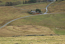 Image © pebblewolf

